The NW11 8 postcode sector is within the county of Greater London.
Did you know? According to the 2021 Census, the NW11 8 postcode sector is home to a bustling 6,214 residents!
Given that each sector allows for 400 unique postcode combinations. Letters C, I, K, M, O and V are not allowed in the last two letters of a postcode. With 145 postcodes already in use, this leaves 255 units available.
The largest settlement in the NW11 8 postal code is GOLDERS GREEN followed by CHILDS HILL , and LONDON .
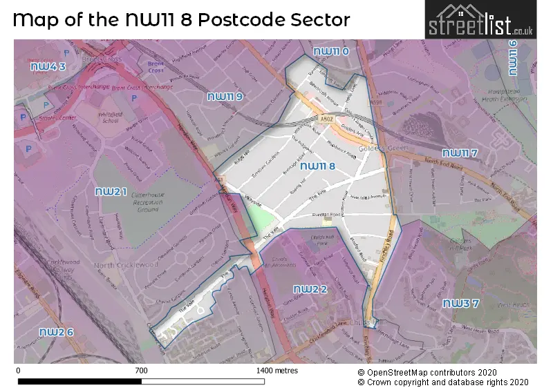
The NW11 8 Postcode shares a border with NW11 0 (GOLDERS GREEN , LONDON , TEMPLE FORTUNE ), NW2 1 (CRICKLEWOOD , LONDON ), NW2 2 (CRICKLEWOOD , CHILDS HILL , LONDON ), NW3 7 (LONDON , HAMPSTEAD ), NW11 7 (GOLDERS GREEN , LONDON ) and NW11 9 (GOLDERS GREEN ).
The sector is within the post town of LONDON.
NW11 8 is a postcode sector within the NW11 postcode district which is within the NW North West London postcode area.
The Royal Mail delivery office for the NW11 8 postal sector is the Golders Green Sdelivery Office.
The area of the NW11 8 postcode sector is 0.32 square miles which is 0.83 square kilometres or 205.03 square acres.


Map of the NW11 8 Postcode Sector
Explore the NW11 8 postcode sector by using our free interactive map.
| N | W | 1 | 1 | - | 8 | X | X |
| N | W | 1 | 1 | Space | 8 | Letter | Letter |
Official List of Streets
Barnet (27 Streets)
Unofficial Streets or Alternative Spellings
Barnet
CLAREMONT ROAD CRICKLEWOOD LANE ELMCROFT AVENUE GAINSBOROUGH GARDENS GRAMPIAN GARDENS GRANVILLE ROAD GREENFIELD GARDENS HAMLET SQUARE HENDON WAY HERMITAGE LANE LLANVANOR ROAD PURLEY AVENUE SANDERSTEAD AVENUE WEST HEATH AVENUE WEST HEATH ROADWeather Forecast for NW11 8
Press Button to Show Forecast for Hampstead Heath Youth Hostel
| Time Period | Icon | Description | Temperature | Rain Probability | Wind |
|---|---|---|---|---|---|
| 15:00 to 18:00 | Partly cloudy (day) | 9.0°C (feels like 7.0°C) | 41.00% | NW 9 mph | |
| 18:00 to 21:00 | Cloudy | 9.0°C (feels like 7.0°C) | 3.00% | N 7 mph | |
| 21:00 to 00:00 | Cloudy | 7.0°C (feels like 5.0°C) | 4.00% | NE 4 mph |
Press Button to Show Forecast for Hampstead Heath Youth Hostel
| Time Period | Icon | Description | Temperature | Rain Probability | Wind |
|---|---|---|---|---|---|
| 00:00 to 03:00 | Cloudy | 6.0°C (feels like 5.0°C) | 5.00% | SSE 4 mph | |
| 03:00 to 06:00 | Cloudy | 6.0°C (feels like 4.0°C) | 5.00% | SSW 4 mph | |
| 06:00 to 09:00 | Cloudy | 6.0°C (feels like 4.0°C) | 7.00% | SW 7 mph | |
| 09:00 to 12:00 | Cloudy | 8.0°C (feels like 6.0°C) | 10.00% | W 9 mph | |
| 12:00 to 15:00 | Cloudy | 10.0°C (feels like 7.0°C) | 10.00% | W 11 mph | |
| 15:00 to 18:00 | Cloudy | 10.0°C (feels like 8.0°C) | 49.00% | W 9 mph | |
| 18:00 to 21:00 | Cloudy | 8.0°C (feels like 6.0°C) | 9.00% | N 7 mph | |
| 21:00 to 00:00 | Cloudy | 7.0°C (feels like 5.0°C) | 8.00% | ENE 7 mph |
Press Button to Show Forecast for Hampstead Heath Youth Hostel
| Time Period | Icon | Description | Temperature | Rain Probability | Wind |
|---|---|---|---|---|---|
| 00:00 to 03:00 | Cloudy | 6.0°C (feels like 3.0°C) | 5.00% | ENE 7 mph | |
| 03:00 to 06:00 | Cloudy | 5.0°C (feels like 2.0°C) | 4.00% | NE 7 mph | |
| 06:00 to 09:00 | Cloudy | 4.0°C (feels like 1.0°C) | 4.00% | NE 7 mph | |
| 09:00 to 12:00 | Partly cloudy (day) | 7.0°C (feels like 5.0°C) | 2.00% | ENE 7 mph | |
| 12:00 to 15:00 | Cloudy | 10.0°C (feels like 9.0°C) | 9.00% | E 7 mph | |
| 15:00 to 18:00 | Overcast | 10.0°C (feels like 9.0°C) | 14.00% | ENE 7 mph | |
| 18:00 to 21:00 | Cloudy | 10.0°C (feels like 8.0°C) | 11.00% | NE 7 mph | |
| 21:00 to 00:00 | Cloudy | 7.0°C (feels like 4.0°C) | 11.00% | E 7 mph |
Press Button to Show Forecast for Hampstead Heath Youth Hostel
| Time Period | Icon | Description | Temperature | Rain Probability | Wind |
|---|---|---|---|---|---|
| 00:00 to 03:00 | Cloudy | 5.0°C (feels like 3.0°C) | 12.00% | ENE 7 mph | |
| 03:00 to 06:00 | Cloudy | 4.0°C (feels like 2.0°C) | 18.00% | NE 7 mph | |
| 06:00 to 09:00 | Overcast | 5.0°C (feels like 2.0°C) | 24.00% | NE 7 mph | |
| 09:00 to 12:00 | Cloudy | 9.0°C (feels like 7.0°C) | 16.00% | ENE 9 mph | |
| 12:00 to 15:00 | Overcast | 11.0°C (feels like 9.0°C) | 20.00% | E 9 mph | |
| 15:00 to 18:00 | Light rain | 12.0°C (feels like 10.0°C) | 52.00% | E 11 mph | |
| 18:00 to 21:00 | Light rain | 11.0°C (feels like 8.0°C) | 53.00% | ENE 9 mph | |
| 21:00 to 00:00 | Light rain | 9.0°C (feels like 6.0°C) | 51.00% | NE 11 mph |
Press Button to Show Forecast for Hampstead Heath Youth Hostel
| Time Period | Icon | Description | Temperature | Rain Probability | Wind |
|---|---|---|---|---|---|
| 00:00 to 03:00 | Light rain | 9.0°C (feels like 6.0°C) | 54.00% | NE 9 mph | |
| 03:00 to 06:00 | Light rain shower (night) | 9.0°C (feels like 7.0°C) | 45.00% | ESE 9 mph | |
| 06:00 to 09:00 | Overcast | 9.0°C (feels like 7.0°C) | 51.00% | SE 7 mph | |
| 09:00 to 12:00 | Light rain shower (day) | 10.0°C (feels like 8.0°C) | 47.00% | SE 9 mph | |
| 12:00 to 15:00 | Heavy rain shower (day) | 12.0°C (feels like 10.0°C) | 63.00% | SSW 9 mph | |
| 15:00 to 18:00 | Light rain shower (day) | 13.0°C (feels like 11.0°C) | 42.00% | SW 11 mph | |
| 18:00 to 21:00 | Partly cloudy (day) | 11.0°C (feels like 9.0°C) | 14.00% | SW 11 mph | |
| 21:00 to 00:00 | Overcast | 10.0°C (feels like 8.0°C) | 11.00% | SW 7 mph |
Schools and Places of Education Within the NW11 8 Postcode Sector
Rimon Jewish Primary School
Free schools
41a Dunstan Road, London, , NW11 8AE
Head: Mrs Sarah Simmons
Ofsted Rating: Good
Inspection: 2018-11-21 (1981 days ago)
Website: Visit Rimon Jewish Primary School Website
Phone: 02082091805
Number of Pupils: 200
House Prices in the NW11 8 Postcode Sector
| Type of Property | 2018 Average | 2018 Sales | 2017 Average | 2017 Sales | 2016 Average | 2016 Sales | 2015 Average | 2015 Sales |
|---|---|---|---|---|---|---|---|---|
| Detached | £1,493,750 | 4 | £1,725,946 | 10 | £1,260,000 | 4 | £1,508,125 | 8 |
| Semi-Detached | £1,500,357 | 7 | £1,367,795 | 22 | £1,366,682 | 11 | £1,327,320 | 25 |
| Terraced | £825,000 | 3 | £740,333 | 3 | £1,375,000 | 2 | £1,180,000 | 5 |
| Flats | £631,276 | 36 | £602,212 | 30 | £571,733 | 31 | £632,321 | 59 |
Important Postcodes NW11 8 in the Postcode Sector
NW11 8AE is the postcode for Rimon Jewish Primary School, 41a Dunstan Road
NW11 8HE is the postcode for London Borough of Barnet, Golders Green Library, 156 Golders Green Road
NW11 8RT is the postcode for Royal Mail Group Property, Post Office, Golders Green Post Office, 879-881 Finchley Road
| The NW11 8 Sector is within these Local Authorities |
|
|---|---|
| The NW11 8 Sector is within these Counties |
|
| The NW11 8 Sector is within these Water Company Areas |
|