The NW3 2 postcode sector is within the county of Greater London.
Did you know? According to the 2021 Census, the NW3 2 postcode sector is home to a bustling 11,970 residents!
Given that each sector allows for 400 unique postcode combinations. Letters C, I, K, M, O and V are not allowed in the last two letters of a postcode. With 240 postcodes already in use, this leaves 160 units available.
The NW3 2 postal code covers the settlement of LONDON .
The NW3 2 Postcode shares a border with N6 6 (LONDON ), NW3 1 (LONDON ), NW5 3 (LONDON ), NW1 8 (LONDON ), NW3 4 (LONDON ), NW3 5 (LONDON ), NW3 7 (LONDON , HAMPSTEAD ), NW5 1 (LONDON , ISLINGTON ), NW5 4 (LONDON ) and NW3 3 (LONDON ).
The sector is within the post town of LONDON.
NW3 2 is a postcode sector within the NW3 postcode district which is within the NW North West London postcode area.
The Royal Mail delivery office for the NW3 2 postal sector is the Hampstead Sdelivery Office.
The area of the NW3 2 postcode sector is 0.51 square miles which is 1.32 square kilometres or 325.11 square acres.

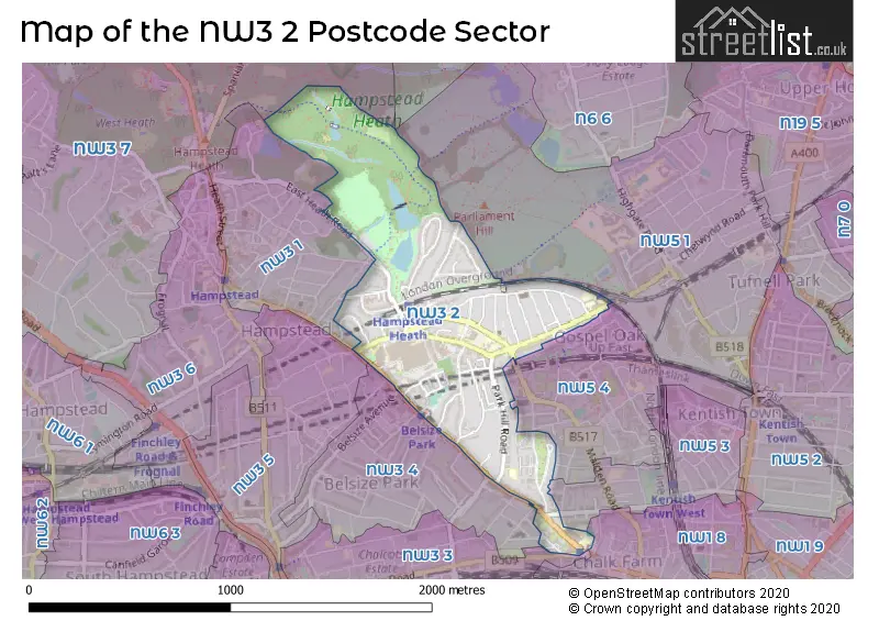
Map of the NW3 2 Postcode Sector
Explore the NW3 2 postcode sector by using our free interactive map.
| N | W | 3 | - | 2 | X | X |
| N | W | 3 | Space | 2 | Letter | Letter |
Official List of Streets
Camden (51 Streets)
Unofficial Streets or Alternative Spellings
Camden
BELSIZE AVENUE BELSIZE LANE DOWNSHIRE HILL EAST HEATH ROAD ETON ROAD GORDON HOUSE ROAD HEATH SIDE LAMBLE STREET LYNDHURST ROAD OAK VILLAGE ORNAN ROAD PRINCE OF WALES ROAD PROVOST ROAD SOUTHAMPTON ROADWeather Forecast for NW3 2
Press Button to Show Forecast for Hampstead
| Time Period | Icon | Description | Temperature | Rain Probability | Wind |
|---|---|---|---|---|---|
| 00:00 to 03:00 | Partly cloudy (night) | 5.0°C (feels like 3.0°C) | 1.00% | NNW 7 mph | |
| 03:00 to 06:00 | Cloudy | 4.0°C (feels like 1.0°C) | 3.00% | NNW 9 mph | |
| 06:00 to 09:00 | Partly cloudy (day) | 4.0°C (feels like 0.0°C) | 1.00% | NNW 9 mph | |
| 09:00 to 12:00 | Cloudy | 7.0°C (feels like 3.0°C) | 3.00% | NNW 11 mph | |
| 12:00 to 15:00 | Cloudy | 9.0°C (feels like 5.0°C) | 4.00% | NNW 13 mph | |
| 15:00 to 18:00 | Cloudy | 9.0°C (feels like 7.0°C) | 4.00% | NNW 11 mph | |
| 18:00 to 21:00 | Partly cloudy (day) | 9.0°C (feels like 7.0°C) | 1.00% | N 7 mph | |
| 21:00 to 00:00 | Partly cloudy (night) | 7.0°C (feels like 5.0°C) | 1.00% | NE 7 mph |
Press Button to Show Forecast for Hampstead
| Time Period | Icon | Description | Temperature | Rain Probability | Wind |
|---|---|---|---|---|---|
| 00:00 to 03:00 | Cloudy | 5.0°C (feels like 4.0°C) | 4.00% | WSW 4 mph | |
| 03:00 to 06:00 | Cloudy | 5.0°C (feels like 2.0°C) | 4.00% | WSW 4 mph | |
| 06:00 to 09:00 | Cloudy | 5.0°C (feels like 2.0°C) | 4.00% | WSW 7 mph | |
| 09:00 to 12:00 | Cloudy | 8.0°C (feels like 6.0°C) | 6.00% | W 9 mph | |
| 12:00 to 15:00 | Cloudy | 10.0°C (feels like 8.0°C) | 9.00% | WNW 9 mph | |
| 15:00 to 18:00 | Overcast | 11.0°C (feels like 9.0°C) | 12.00% | WNW 9 mph | |
| 18:00 to 21:00 | Cloudy | 10.0°C (feels like 8.0°C) | 9.00% | NW 9 mph | |
| 21:00 to 00:00 | Cloudy | 8.0°C (feels like 6.0°C) | 7.00% | NNE 7 mph |
Press Button to Show Forecast for Hampstead
| Time Period | Icon | Description | Temperature | Rain Probability | Wind |
|---|---|---|---|---|---|
| 00:00 to 03:00 | Cloudy | 6.0°C (feels like 4.0°C) | 6.00% | E 7 mph | |
| 03:00 to 06:00 | Cloudy | 5.0°C (feels like 3.0°C) | 6.00% | NNE 7 mph | |
| 06:00 to 09:00 | Cloudy | 5.0°C (feels like 3.0°C) | 7.00% | ENE 7 mph | |
| 09:00 to 12:00 | Cloudy | 8.0°C (feels like 6.0°C) | 8.00% | E 9 mph | |
| 12:00 to 15:00 | Overcast | 10.0°C (feels like 9.0°C) | 13.00% | SE 9 mph | |
| 15:00 to 18:00 | Overcast | 10.0°C (feels like 9.0°C) | 16.00% | SE 9 mph | |
| 18:00 to 21:00 | Cloudy | 9.0°C (feels like 7.0°C) | 11.00% | ESE 9 mph | |
| 21:00 to 00:00 | Cloudy | 8.0°C (feels like 6.0°C) | 12.00% | ESE 9 mph |
Press Button to Show Forecast for Hampstead
| Time Period | Icon | Description | Temperature | Rain Probability | Wind |
|---|---|---|---|---|---|
| 00:00 to 03:00 | Cloudy | 7.0°C (feels like 4.0°C) | 14.00% | ESE 9 mph | |
| 03:00 to 06:00 | Cloudy | 7.0°C (feels like 4.0°C) | 15.00% | ESE 7 mph | |
| 06:00 to 09:00 | Cloudy | 7.0°C (feels like 5.0°C) | 14.00% | ESE 9 mph | |
| 09:00 to 12:00 | Cloudy | 10.0°C (feels like 8.0°C) | 12.00% | ESE 9 mph | |
| 12:00 to 15:00 | Light rain | 12.0°C (feels like 10.0°C) | 40.00% | SE 11 mph | |
| 15:00 to 18:00 | Cloudy | 12.0°C (feels like 10.0°C) | 16.00% | ESE 11 mph | |
| 18:00 to 21:00 | Light rain shower (day) | 11.0°C (feels like 9.0°C) | 32.00% | ENE 11 mph | |
| 21:00 to 00:00 | Cloudy | 10.0°C (feels like 8.0°C) | 14.00% | ENE 9 mph |
Schools and Places of Education Within the NW3 2 Postcode Sector
Fleet Primary School
Community school
Fleet Road, London, , NW3 2QT
Head: Donald McGibbon
Ofsted Rating: Good
Inspection: 2022-10-06 (566 days ago)
Website: Visit Fleet Primary School Website
Phone: 02074852028
Number of Pupils: 228
Gospel Oak Primary School
Community school
Mansfield Road, London, , NW3 2JB
Head: Mr John Hayes
Ofsted Rating: Outstanding
Inspection: 2021-10-20 (917 days ago)
Website: Visit Gospel Oak Primary School Website
Phone: 02074857435
Number of Pupils: 452
Haverstock School
Community school
24 Haverstock Hill, London, , NW3 2BQ
Head: Ms Katie Metselaar
Ofsted Rating: Good
Inspection: 2019-07-03 (1757 days ago)
Website: Visit Haverstock School Website
Phone: 02072670975
Number of Pupils: 982
Heath School
Pupil referral unit
Agincourt Road, London, , NW3 2NY
Head: Mr Alex Wilson
Ofsted Rating: Good
Inspection: 2017-11-29 (2338 days ago)
Website: Visit Heath School Website
Phone: 02079748906
Number of Pupils: 19
Rosary Catholic Primary School
Voluntary aided school
238 Haverstock Hill, London, , NW3 2AE
Head: Miss Sophie Kennedy
Ofsted Rating: Good
Inspection: 2022-09-29 (573 days ago)
Website: Visit Rosary Catholic Primary School Website
Phone: 02077946292
Number of Pupils: 322
Royal Free Hospital Children's School
Community special school
Floor 6 - 6 West B, London, , NW3 2QG
Head: Mr Alex Yates
Ofsted Rating: Outstanding
Inspection: 2019-10-10 (1658 days ago)
Website: Visit Royal Free Hospital Children's School Website
Phone: 02074726298
Number of Pupils: 81
House Prices in the NW3 2 Postcode Sector
| Type of Property | 2018 Average | 2018 Sales | 2017 Average | 2017 Sales | 2016 Average | 2016 Sales | 2015 Average | 2015 Sales |
|---|---|---|---|---|---|---|---|---|
| Detached | £5,762,500 | 3 | £1,671,000 | 3 | £0 | 0 | £2,025,000 | 1 |
| Semi-Detached | £3,106,850 | 10 | £3,723,333 | 6 | £3,892,250 | 5 | £3,907,209 | 9 |
| Terraced | £1,947,563 | 16 | £1,825,526 | 23 | £2,334,565 | 23 | £1,884,278 | 18 |
| Flats | £734,400 | 89 | £741,843 | 145 | £786,065 | 99 | £685,218 | 116 |
Important Postcodes NW3 2 in the Postcode Sector
NW3 2AE is the postcode for Rosary RC Primary School, 238 Haverstock Hill
NW3 2BQ is the postcode for Haverstock School, 24 Haverstock Hill
NW3 2JB is the postcode for Gospel Oak Primary School, Mansfield Road
NW3 2NY is the postcode for CCFL - Camden Centre for Learning Key Stage 4 Schoo, Agincourt Road, Camden, CCFL - Camden Centre for Learning Key Stage 4 School, Agincourt Road, Camden, and SECONDARY LEARNING SUPPORT SERVICE KS4, Camden Local Education Authority, Agincourt House, Agincourt Road
NW3 2PF is the postcode for Royal Free Hospital & School of Medicine, Rowland Hill Street
NW3 2QG is the postcode for Royal Free Hampstead NHS Trust, Royal Free Hospital, Royal Free Recreation Club, Fleet Rd, THE GROVE CENTRE - LG, UG AND 1ST FLOORS, Royal Free Hampstead NHS Trust, Royal Free Hospital, and Royal Free London NHS Foundation Trust, Royal Free Hospital, Pond Street
NW3 2QT is the postcode for Fleet Primary School, Fleet Road
NW3 2RR is the postcode for Keats House Museum, 10 Keats Grove
NW3 2SE is the postcode for 3 Park End
| The NW3 2 Sector is within these Local Authorities |
|
|---|---|
| The NW3 2 Sector is within these Counties |
|
| The NW3 2 Sector is within these Water Company Areas |
|
Tourist Attractions within the NW3 2 Postcode Area
We found 1 visitor attractions within the NW3 postcode area
| Keats House |
|---|
| Historic Properties |
| Historic House / House and Garden / Palace |
| View Keats House on Google Maps |