The NW4 3 postcode sector is within the county of Greater London.
Did you know? According to the 2021 Census, the NW4 3 postcode sector is home to a bustling 9,275 residents!
Given that each sector allows for 400 unique postcode combinations. Letters C, I, K, M, O and V are not allowed in the last two letters of a postcode. With 191 postcodes already in use, this leaves 209 units available.
The largest settlement in the NW4 3 postal code is HENDON followed by WEST HENDON , and BRENT CROSS .
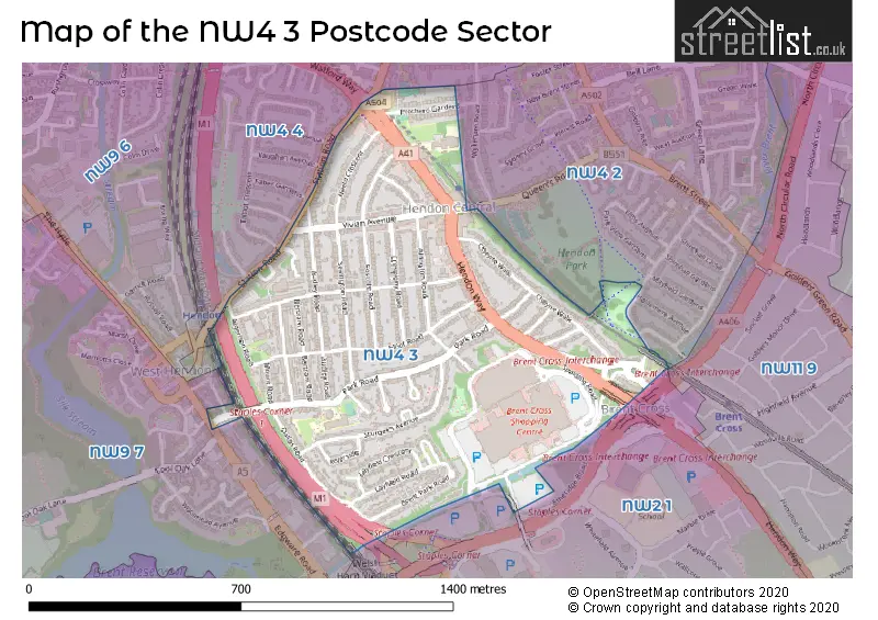
The NW4 3 Postcode shares a border with NW4 2 (HENDON ), NW2 1 (CRICKLEWOOD , LONDON ), NW4 4 (HENDON ), NW9 6 (COLINDALE , KINGSBURY , THE HYDE ) and NW9 7 (COLINDALE , LONDON ).
The sector is within the post town of LONDON.
NW4 3 is a postcode sector within the NW4 postcode district which is within the NW North West London postcode area.
The Royal Mail delivery office for the NW4 3 postal sector is the Hendon Sdelivery Office.
The area of the NW4 3 postcode sector is 0.49 square miles which is 1.26 square kilometres or 311.87 square acres.
The NW4 3 postcode sector is crossed by the M1 motorway.
Waterways within the NW4 3 postcode sector include the River Brent.

Map of the NW4 3 Postcode Sector
Explore the NW4 3 postcode sector by using our free interactive map.
| N | W | 4 | - | 3 | X | X |
| N | W | 4 | Space | 3 | Letter | Letter |
Official List of Streets
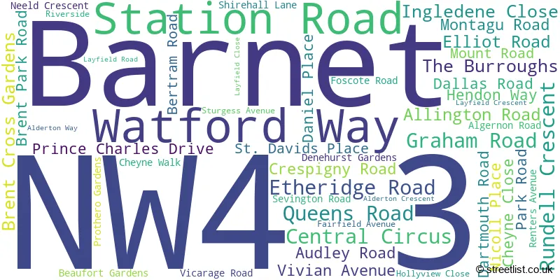
Barnet (49 Streets)
Unofficial Streets or Alternative Spellings
Weather Forecast for NW4 3
Press Button to Show Forecast for Hampstead Heath Youth Hostel
| Time Period | Icon | Description | Temperature | Rain Probability | Wind |
|---|---|---|---|---|---|
| 00:00 to 03:00 | Partly cloudy (night) | 5.0°C (feels like 3.0°C) | 1.00% | NNW 7 mph | |
| 03:00 to 06:00 | Cloudy | 4.0°C (feels like 1.0°C) | 3.00% | NNW 9 mph | |
| 06:00 to 09:00 | Partly cloudy (day) | 4.0°C (feels like 1.0°C) | 1.00% | NNW 9 mph | |
| 09:00 to 12:00 | Cloudy | 7.0°C (feels like 4.0°C) | 4.00% | NNW 11 mph | |
| 12:00 to 15:00 | Cloudy | 9.0°C (feels like 6.0°C) | 4.00% | NNW 11 mph | |
| 15:00 to 18:00 | Cloudy | 10.0°C (feels like 7.0°C) | 4.00% | N 11 mph | |
| 18:00 to 21:00 | Cloudy | 9.0°C (feels like 7.0°C) | 4.00% | N 7 mph | |
| 21:00 to 00:00 | Partly cloudy (night) | 7.0°C (feels like 5.0°C) | 1.00% | NE 4 mph |
Press Button to Show Forecast for Hampstead Heath Youth Hostel
| Time Period | Icon | Description | Temperature | Rain Probability | Wind |
|---|---|---|---|---|---|
| 00:00 to 03:00 | Cloudy | 6.0°C (feels like 4.0°C) | 4.00% | W 4 mph | |
| 03:00 to 06:00 | Cloudy | 5.0°C (feels like 3.0°C) | 4.00% | WSW 4 mph | |
| 06:00 to 09:00 | Cloudy | 5.0°C (feels like 3.0°C) | 4.00% | WSW 4 mph | |
| 09:00 to 12:00 | Cloudy | 8.0°C (feels like 6.0°C) | 6.00% | W 9 mph | |
| 12:00 to 15:00 | Overcast | 11.0°C (feels like 8.0°C) | 12.00% | WNW 9 mph | |
| 15:00 to 18:00 | Cloudy | 11.0°C (feels like 9.0°C) | 8.00% | WNW 9 mph | |
| 18:00 to 21:00 | Cloudy | 10.0°C (feels like 9.0°C) | 9.00% | NW 7 mph | |
| 21:00 to 00:00 | Cloudy | 8.0°C (feels like 6.0°C) | 7.00% | NNE 7 mph |
Press Button to Show Forecast for Hampstead Heath Youth Hostel
| Time Period | Icon | Description | Temperature | Rain Probability | Wind |
|---|---|---|---|---|---|
| 00:00 to 03:00 | Cloudy | 6.0°C (feels like 5.0°C) | 5.00% | N 4 mph | |
| 03:00 to 06:00 | Cloudy | 5.0°C (feels like 3.0°C) | 5.00% | ENE 4 mph | |
| 06:00 to 09:00 | Cloudy | 5.0°C (feels like 3.0°C) | 7.00% | E 7 mph | |
| 09:00 to 12:00 | Cloudy | 8.0°C (feels like 6.0°C) | 9.00% | ESE 7 mph | |
| 12:00 to 15:00 | Overcast | 10.0°C (feels like 9.0°C) | 13.00% | SE 7 mph | |
| 15:00 to 18:00 | Cloudy | 10.0°C (feels like 9.0°C) | 15.00% | SE 7 mph | |
| 18:00 to 21:00 | Cloudy | 10.0°C (feels like 8.0°C) | 13.00% | ESE 9 mph | |
| 21:00 to 00:00 | Cloudy | 8.0°C (feels like 6.0°C) | 11.00% | ESE 7 mph |
Press Button to Show Forecast for Hampstead Heath Youth Hostel
| Time Period | Icon | Description | Temperature | Rain Probability | Wind |
|---|---|---|---|---|---|
| 00:00 to 03:00 | Cloudy | 7.0°C (feels like 5.0°C) | 14.00% | ESE 7 mph | |
| 03:00 to 06:00 | Cloudy | 7.0°C (feels like 5.0°C) | 16.00% | E 7 mph | |
| 06:00 to 09:00 | Cloudy | 7.0°C (feels like 5.0°C) | 14.00% | E 7 mph | |
| 09:00 to 12:00 | Cloudy | 10.0°C (feels like 8.0°C) | 14.00% | ESE 9 mph | |
| 12:00 to 15:00 | Light rain shower (day) | 12.0°C (feels like 10.0°C) | 30.00% | ESE 9 mph | |
| 15:00 to 18:00 | Light rain | 12.0°C (feels like 11.0°C) | 44.00% | ESE 9 mph | |
| 18:00 to 21:00 | Light rain shower (day) | 12.0°C (feels like 10.0°C) | 32.00% | ESE 9 mph | |
| 21:00 to 00:00 | Cloudy | 10.0°C (feels like 9.0°C) | 15.00% | ESE 7 mph |
Schools and Places of Education Within the NW4 3 Postcode Sector
Barnet Hill Academy
Other independent school
10a Montagu Road, London, , NW4 3ES
Head: Mr Shuayb Patel
Ofsted Rating: Requires improvement
Inspection: 2022-06-30 (664 days ago)
Website: Visit Barnet Hill Academy Website
Phone: 02034112660
Number of Pupils: 164
Parkfield Primary School
Academy sponsor led
St David's Place, London, , NW4 3PJ
Head: Claire Cunningham
Ofsted Rating: Good
Inspection: 2019-03-06 (1876 days ago)
Website: Visit Parkfield Primary School Website
Phone: 02082020454
Number of Pupils: 454
House Prices in the NW4 3 Postcode Sector
| Type of Property | 2018 Average | 2018 Sales | 2017 Average | 2017 Sales | 2016 Average | 2016 Sales | 2015 Average | 2015 Sales |
|---|---|---|---|---|---|---|---|---|
| Detached | £1,101,191 | 11 | £1,232,325 | 8 | £1,019,077 | 9 | £1,021,000 | 11 |
| Semi-Detached | £747,250 | 8 | £606,192 | 13 | £616,467 | 6 | £530,988 | 16 |
| Terraced | £659,964 | 17 | £596,792 | 12 | £597,550 | 10 | £577,971 | 17 |
| Flats | £408,512 | 21 | £359,868 | 36 | £375,003 | 43 | £313,039 | 45 |
Important Postcodes NW4 3 in the Postcode Sector
NW4 3ES is the postcode for Ayesha Community Education School, 10a Montagu Road
NW4 3PJ is the postcode for Parkfield Primary School, 17 St. Davids Place, and PARKFIELD PRIMARY SCHOOL, 17 ST DAVIDS PLACE, HENDON
NW4 3SL is the postcode for St. Marys & St. Johns C of E Primary School, Prothero Gardens
NW4 3SP is the postcode for COLINHURST HOUSE, 168 STATION ROAD, HENDON, and Colinhurst House, 168, Station Road
NW4 3UB is the postcode for Parkfield Primary School, St. David's Place
| The NW4 3 Sector is within these Local Authorities |
|
|---|---|
| The NW4 3 Sector is within these Counties |
|
| The NW4 3 Sector is within these Water Company Areas |
|