The NW4 4 postcode sector is within the county of Greater London.
Did you know? According to the 2021 Census, the NW4 4 postcode sector is home to a bustling 8,840 residents!
Given that each sector allows for 400 unique postcode combinations. Letters C, I, K, M, O and V are not allowed in the last two letters of a postcode. With 189 postcodes already in use, this leaves 211 units available.
The NW4 4 postal code covers the settlement of HENDON .
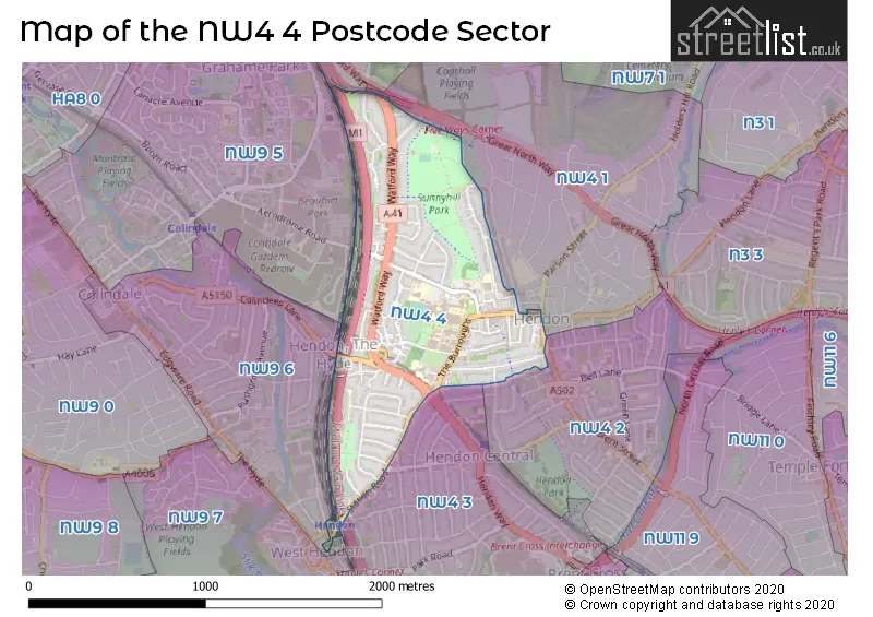
The NW4 4 Postcode shares a border with NW4 2 (HENDON ), NW4 1 (HENDON , CHURCH END ), NW7 2 (MILL HILL , THE HALE , MILL HILL SOUTH SECTION ), NW9 5 (COLINDALE , GRAHAME PARK SOUTH SECTION ), NW9 6 (COLINDALE , KINGSBURY , THE HYDE ) and NW4 3 (HENDON , WEST HENDON , BRENT CROSS ).
The sector is within the post town of LONDON.
NW4 4 is a postcode sector within the NW4 postcode district which is within the NW North West London postcode area.
The Royal Mail delivery office for the NW4 4 postal sector is the Hendon Sdelivery Office.
The area of the NW4 4 postcode sector is 0.62 square miles which is 1.62 square kilometres or 399.50 square acres.
The NW4 4 postcode sector is crossed by the M1 motorway.
The NW4 4 postcode sector is crossed by the A1 Major A road.

Map of the NW4 4 Postcode Sector
Explore the NW4 4 postcode sector by using our free interactive map.
| N | W | 4 | - | 4 | X | X |
| N | W | 4 | Space | 4 | Letter | Letter |
Official List of Streets
Barnet (61 Streets)
Unofficial Streets or Alternative Spellings
Weather Forecast for NW4 4
Press Button to Show Forecast for Hampstead Heath Youth Hostel
| Time Period | Icon | Description | Temperature | Rain Probability | Wind |
|---|---|---|---|---|---|
| 03:00 to 06:00 | Cloudy | 9.0°C (feels like 6.0°C) | 45.00% | W 11 mph | |
| 06:00 to 09:00 | Cloudy | 9.0°C (feels like 7.0°C) | 54.00% | WNW 11 mph | |
| 09:00 to 12:00 | Light rain shower (day) | 10.0°C (feels like 7.0°C) | 35.00% | NW 16 mph | |
| 12:00 to 15:00 | Cloudy | 11.0°C (feels like 8.0°C) | 6.00% | NW 16 mph | |
| 15:00 to 18:00 | Cloudy | 11.0°C (feels like 8.0°C) | 48.00% | N 13 mph | |
| 18:00 to 21:00 | Cloudy | 9.0°C (feels like 7.0°C) | 16.00% | NNE 9 mph | |
| 21:00 to 00:00 | Cloudy | 7.0°C (feels like 4.0°C) | 6.00% | NNE 9 mph |
Press Button to Show Forecast for Hampstead Heath Youth Hostel
| Time Period | Icon | Description | Temperature | Rain Probability | Wind |
|---|---|---|---|---|---|
| 00:00 to 03:00 | Clear night | 5.0°C (feels like 2.0°C) | 1.00% | N 9 mph | |
| 03:00 to 06:00 | Partly cloudy (night) | 4.0°C (feels like 1.0°C) | 1.00% | NNW 9 mph | |
| 06:00 to 09:00 | Partly cloudy (day) | 4.0°C (feels like 1.0°C) | 2.00% | NNW 9 mph | |
| 09:00 to 12:00 | Cloudy | 7.0°C (feels like 4.0°C) | 7.00% | N 11 mph | |
| 12:00 to 15:00 | Overcast | 9.0°C (feels like 6.0°C) | 8.00% | N 11 mph | |
| 15:00 to 18:00 | Overcast | 10.0°C (feels like 7.0°C) | 8.00% | N 11 mph | |
| 18:00 to 21:00 | Cloudy | 9.0°C (feels like 7.0°C) | 5.00% | NNE 9 mph | |
| 21:00 to 00:00 | Partly cloudy (night) | 7.0°C (feels like 5.0°C) | 2.00% | NNE 7 mph |
Press Button to Show Forecast for Hampstead Heath Youth Hostel
| Time Period | Icon | Description | Temperature | Rain Probability | Wind |
|---|---|---|---|---|---|
| 00:00 to 03:00 | Cloudy | 5.0°C (feels like 4.0°C) | 5.00% | N 4 mph | |
| 03:00 to 06:00 | Cloudy | 5.0°C (feels like 3.0°C) | 5.00% | NNW 4 mph | |
| 06:00 to 09:00 | Overcast | 5.0°C (feels like 3.0°C) | 9.00% | N 4 mph | |
| 09:00 to 12:00 | Overcast | 7.0°C (feels like 5.0°C) | 9.00% | NNE 9 mph | |
| 12:00 to 15:00 | Overcast | 9.0°C (feels like 7.0°C) | 11.00% | NNE 9 mph | |
| 15:00 to 18:00 | Cloudy | 10.0°C (feels like 8.0°C) | 6.00% | NNE 11 mph | |
| 18:00 to 21:00 | Cloudy | 9.0°C (feels like 7.0°C) | 5.00% | NNE 11 mph | |
| 21:00 to 00:00 | Clear night | 7.0°C (feels like 4.0°C) | 2.00% | NNE 9 mph |
Press Button to Show Forecast for Hampstead Heath Youth Hostel
| Time Period | Icon | Description | Temperature | Rain Probability | Wind |
|---|---|---|---|---|---|
| 00:00 to 03:00 | Partly cloudy (night) | 6.0°C (feels like 3.0°C) | 2.00% | NNE 7 mph | |
| 03:00 to 06:00 | Clear night | 5.0°C (feels like 2.0°C) | 1.00% | NNE 7 mph | |
| 06:00 to 09:00 | Sunny day | 5.0°C (feels like 2.0°C) | 2.00% | NNE 7 mph | |
| 09:00 to 12:00 | Cloudy | 8.0°C (feels like 6.0°C) | 6.00% | NNE 9 mph | |
| 12:00 to 15:00 | Overcast | 10.0°C (feels like 8.0°C) | 10.00% | NNE 11 mph | |
| 15:00 to 18:00 | Cloudy | 10.0°C (feels like 8.0°C) | 9.00% | NE 11 mph | |
| 18:00 to 21:00 | Cloudy | 9.0°C (feels like 7.0°C) | 7.00% | NE 11 mph | |
| 21:00 to 00:00 | Partly cloudy (night) | 7.0°C (feels like 5.0°C) | 2.00% | NE 9 mph |
Schools and Places of Education Within the NW4 4 Postcode Sector
St Joseph's Catholic Primary School
Voluntary aided school
Watford Way, London, , NW4 4TY
Head: Dr James Lane
Ofsted Rating: Good
Inspection: 2021-10-07 (925 days ago)
Website: Visit St Joseph's Catholic Primary School Website
Phone: 02082025229
Number of Pupils: 501
St Mary's and St John's CofE School
Voluntary aided school
Bennett House, London, , NW4 4QR
Head: Principal Gavin Smith
Ofsted Rating: Good
Inspection: 2017-07-05 (2480 days ago)
Website: Visit St Mary's and St John's CofE School Website
Phone: 02082020026
Number of Pupils: 1647
Sunnyfields Primary School
Community school
Hatchcroft, London, , NW4 4JH
Head: Ms Lisa Meyer
Ofsted Rating: Good
Inspection: 2022-06-29 (660 days ago)
Website: Visit Sunnyfields Primary School Website
Phone: 02082033113
Number of Pupils: 250
House Prices in the NW4 4 Postcode Sector
| Type of Property | 2018 Average | 2018 Sales | 2017 Average | 2017 Sales | 2016 Average | 2016 Sales | 2015 Average | 2015 Sales |
|---|---|---|---|---|---|---|---|---|
| Detached | £1,286,571 | 7 | £1,162,308 | 13 | £1,047,495 | 10 | £1,335,500 | 10 |
| Semi-Detached | £689,382 | 17 | £638,881 | 21 | £576,143 | 21 | £568,500 | 22 |
| Terraced | £590,929 | 7 | £530,855 | 9 | £569,045 | 11 | £536,919 | 13 |
| Flats | £297,670 | 42 | £310,611 | 44 | £330,803 | 55 | £291,381 | 80 |
Important Postcodes NW4 4 in the Postcode Sector
NW4 4AA is the postcode for Royal Mail, Hendon Delivery Office, Brampton Grove
NW4 4BD is the postcode for 1, Burroughs Parade
NW4 4BL is the postcode for Hendon Fire Station, 91 The Burroughs
NW4 4BQ is the postcode for London Borough of Barnet, Hendon Public Library, The Burroughs, and Hendon Town Hall, London Borough of Barnet
NW4 4BT is the postcode for RITTERMAN BUILDING, Middlesex University, The Burroughs, THE VINE, Middlesex University, The Burroughs, MDX HOUSE, Middlesex University, The Burroughs, FENELLA, Middlesex University Business School, The Burroughs, THE GROVE, Middlesex University, The Burroughs, BUILDING 10, Hendon Campus, Middlesex University, RAVENSFIELD, Middlesex University Business School, The Burroughs, FENELLA, Middlesex University, The Burroughs, BUILDING 9, Middlesex University, The Burroughs, HATCHCROFT BUILDING, Middlesex University, The Burroughs, STUDENT FORUM AND REAL TENNIS CENTRE, Middlesex University, The Burroughs, IVY HALLS, Middlesex University Business School, The Burroughs, SHEPPARD LIBRARY, Middlesex University, The Burroughs, TOWN HALL OFFICES, Middlesex University Business School, The Burroughs, TOWN HALL OFFICES, Middlesex University, The Burroughs, HATCHCROFT BUILDING, Middlesex University Business School, The Burroughs, IVY HALLS, Middlesex University, The Burroughs, WILLIAMS BUILDING, Middlesex University, The Burroughs, RAVENSFIELD, Middlesex University, The Burroughs, WILLIAMS BUILDING, Middlesex University Business School, The Burroughs, and COLLEGE BUILDING, Middlesex University, The Burroughs
NW4 4JH is the postcode for Sunnyfields Primary School, Hatchcroft, and SUNNYFIELDS PRIMARY SCHOOL, HATCHCROFT, HENDON
NW4 4JS is the postcode for Model Farmhouse, Greyhound Hill
NW4 4QR is the postcode for St. Marys & St. Johns C of E Primary School, Sunningfields Road, and BENNETT HOUSE CAMPUS, St. Marys & St. Johns C of E School, Sunningfields Road
NW4 4TY is the postcode for St. Josephs Junior School, St. Josephs, Watford Way, St Joseph's Catholic Primary School, Watford Way, HENDON, and St. Josephs Catholic Primary School, St. Josephs
| The NW4 4 Sector is within these Local Authorities |
|
|---|---|
| The NW4 4 Sector is within these Counties |
|
| The NW4 4 Sector is within these Water Company Areas |
|