The NW6 postcode district is a postal district located in the NW London - NW postcode area with a population of 66,446 residents according to the 2021 England and Wales Census.
The area of the NW6 postcode district is 1.98 square miles which is 5.13 square kilometres or 1,266.48 acres.
Currently, the NW6 district has about 1280 postcode units spread across 7 geographic postcode sectors.
Given that each sector allows for 400 unique postcode combinations, the district has a capacity of 2,800 postcodes. With 1280 postcodes already in use, this leaves 1520 units available.
The NW6 postal code covers the settlement of LONDON.
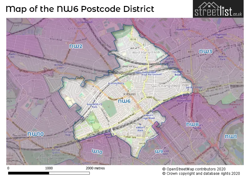
The NW6 Postcode shares a border with NW2 (LONDON, CRICKLEWOOD), NW3 (LONDON), W10 (LONDON), W9 (LONDON), NW8 (LONDON) and NW10 (LONDON).
The primary settlement in the NW6 postcode district is Camden, located in the county of Greater London. Other significant settlements in this district include Brent and Westminster. Camden has the highest count of postcodes in this area, followed by Brent. The most significant post town in the NW6 postcode district is London.
For the district NW6, we have data on 8 postcode sectors. Here's a breakdown: The sector NW6 1, covers Camden in Greater London. The sector NW6 2, covers Camden in Greater London. The sector NW6 3, covers Camden in Greater London. The sector NW6 4, covers Camden in Greater London. The sector NW6 5, covers Brent and Westminster and Camden in Greater London. The sector NW6 6, covers Brent in Greater London. The sector NW6 7, covers Brent in Greater London. The sector NW6 9 is non-geographic. It's often designated for PO Boxes, large organisations, or special services.

Map of the NW6 Postcode District
Explore the NW6 postcode district by using our free interactive map.
When it comes to local government, postal geography often disregards political borders. However, for a breakdown in the NW6 District: the district mostly encompasses the Camden London Boro (694 postcodes), followed by the Brent London Boro area (560 postcodes), and finally, the City of Westminster London Boro area (46 postcodes).
Recent House Sales in NW6
| Date | Price | Address |
|---|---|---|
| 20/10/2023 | £950,000 | Brondesbury Road, London, NW6 6RX |
| 13/10/2023 | £455,000 | Malvern Road, London, NW6 5PU |
| 13/10/2023 | £450,000 | Hazelmere Road, London, NW6 6PY |
| 02/10/2023 | £375,000 | Willesden Lane, London, NW6 7XF |
| 02/10/2023 | £375,000 | Willesden Lane, London, NW6 7XF |
| 28/09/2023 | £860,000 | Maple Mews, London, NW6 5UZ |
| 25/09/2023 | £375,000 | Brondesbury Road, London, NW6 6SB |
| 15/09/2023 | £460,000 | Broadhurst Gardens, London, NW6 3QR |
| 08/09/2023 | £625,000 | Greencroft Gardens, London, NW6 3LL |
| 08/09/2023 | £527,000 | Carlton Vale, London, NW6 5EN |
Weather Forecast for NW6
Press Button to Show Forecast for Lord's Marylebone C.C.
| Time Period | Icon | Description | Temperature | Rain Probability | Wind |
|---|---|---|---|---|---|
| 03:00 to 06:00 | Cloudy | 5.0°C (feels like 3.0°C) | 3.00% | NNW 9 mph | |
| 06:00 to 09:00 | Partly cloudy (day) | 5.0°C (feels like 2.0°C) | 1.00% | NNW 9 mph | |
| 09:00 to 12:00 | Partly cloudy (day) | 8.0°C (feels like 5.0°C) | 4.00% | NNW 11 mph | |
| 12:00 to 15:00 | Cloudy | 10.0°C (feels like 8.0°C) | 4.00% | NNW 11 mph | |
| 15:00 to 18:00 | Cloudy | 11.0°C (feels like 9.0°C) | 4.00% | NNW 11 mph | |
| 18:00 to 21:00 | Cloudy | 10.0°C (feels like 8.0°C) | 3.00% | N 7 mph | |
| 21:00 to 00:00 | Partly cloudy (night) | 8.0°C (feels like 7.0°C) | 1.00% | NE 4 mph |
Press Button to Show Forecast for Lord's Marylebone C.C.
| Time Period | Icon | Description | Temperature | Rain Probability | Wind |
|---|---|---|---|---|---|
| 00:00 to 03:00 | Cloudy | 7.0°C (feels like 5.0°C) | 4.00% | WSW 4 mph | |
| 03:00 to 06:00 | Cloudy | 6.0°C (feels like 4.0°C) | 4.00% | WSW 4 mph | |
| 06:00 to 09:00 | Cloudy | 6.0°C (feels like 4.0°C) | 4.00% | WSW 4 mph | |
| 09:00 to 12:00 | Cloudy | 9.0°C (feels like 7.0°C) | 6.00% | W 7 mph | |
| 12:00 to 15:00 | Overcast | 11.0°C (feels like 9.0°C) | 11.00% | WNW 9 mph | |
| 15:00 to 18:00 | Cloudy | 12.0°C (feels like 10.0°C) | 9.00% | WNW 9 mph | |
| 18:00 to 21:00 | Cloudy | 11.0°C (feels like 10.0°C) | 9.00% | NW 7 mph | |
| 21:00 to 00:00 | Cloudy | 9.0°C (feels like 7.0°C) | 7.00% | NNE 7 mph |
Press Button to Show Forecast for Lord's Marylebone C.C.
| Time Period | Icon | Description | Temperature | Rain Probability | Wind |
|---|---|---|---|---|---|
| 00:00 to 03:00 | Overcast | 8.0°C (feels like 6.0°C) | 8.00% | E 4 mph | |
| 03:00 to 06:00 | Cloudy | 6.0°C (feels like 5.0°C) | 6.00% | NNE 4 mph | |
| 06:00 to 09:00 | Cloudy | 6.0°C (feels like 4.0°C) | 7.00% | ENE 4 mph | |
| 09:00 to 12:00 | Cloudy | 8.0°C (feels like 7.0°C) | 8.00% | E 7 mph | |
| 12:00 to 15:00 | Overcast | 11.0°C (feels like 9.0°C) | 13.00% | SE 7 mph | |
| 15:00 to 18:00 | Light rain | 11.0°C (feels like 10.0°C) | 49.00% | ESE 7 mph | |
| 18:00 to 21:00 | Cloudy | 11.0°C (feels like 9.0°C) | 11.00% | ESE 9 mph | |
| 21:00 to 00:00 | Cloudy | 9.0°C (feels like 7.0°C) | 11.00% | ESE 7 mph |
Press Button to Show Forecast for Lord's Marylebone C.C.
| Time Period | Icon | Description | Temperature | Rain Probability | Wind |
|---|---|---|---|---|---|
| 00:00 to 03:00 | Cloudy | 8.0°C (feels like 6.0°C) | 14.00% | ESE 7 mph | |
| 03:00 to 06:00 | Cloudy | 8.0°C (feels like 6.0°C) | 15.00% | ESE 7 mph | |
| 06:00 to 09:00 | Cloudy | 8.0°C (feels like 6.0°C) | 14.00% | ESE 7 mph | |
| 09:00 to 12:00 | Overcast | 10.0°C (feels like 9.0°C) | 16.00% | SE 7 mph | |
| 12:00 to 15:00 | Light rain shower (day) | 13.0°C (feels like 11.0°C) | 30.00% | SE 9 mph | |
| 15:00 to 18:00 | Cloudy | 13.0°C (feels like 11.0°C) | 16.00% | ESE 9 mph | |
| 18:00 to 21:00 | Light rain shower (day) | 13.0°C (feels like 11.0°C) | 32.00% | ENE 9 mph | |
| 21:00 to 00:00 | Cloudy | 11.0°C (feels like 9.0°C) | 14.00% | ENE 7 mph |
Where is the NW6 Postcode District?
The NW6 postcode district is located in London. It is specifically situated nearby several towns: Kilburn, Maida Hill, North Kensington, North Section Borough of Barnet, Childs Hill, and Little Venice. This district is approximately 3.9 miles away from the center of London.
The district is within the post town of LONDON.
The sector has postcodes within the nation of England.
The NW6 Postcode District is covers the following regions.
- Camden and City of London - Inner London - West - London
- Brent - Outer London - West and North West - London
- Westminster - Inner London - West - London
| Postcode Sector | Delivery Office |
|---|---|
| NW6 1 | Kilburn Sdelivery Office |
| NW6 2 | Kilburn Sdelivery Office |
| NW6 3 | Kilburn Sdelivery Office |
| NW6 4 | Kilburn Sdelivery Office |
| NW6 5 | Kilburn Sdelivery Office |
| NW6 6 | Kilburn Sdelivery Office |
| NW6 7 | Kilburn Sdelivery Office |
| N | W | 6 | - | X | X | X |
| N | W | 6 | Space | Numeric | Letter | Letter |
Current Monthly Rental Prices
| # Bedrooms | Min Price | Max Price | Avg Price |
|---|---|---|---|
| £133 | £5,928 | £1,285 | |
| 1 | £1,250 | £6,231 | £2,085 |
| 2 | £1,907 | £11,405 | £3,295 |
| 3 | £1,993 | £20,423 | £4,661 |
| 4 | £2,750 | £40,040 | £7,227 |
| 5 | £5,500 | £19,998 | £11,944 |
| 6 | £5,900 | £19,500 | £12,700 |
Current House Prices
| # Bedrooms | Min Price | Max Price | Avg Price |
|---|---|---|---|
| £250,000 | £1,650,000 | £555,619 | |
| 1 | £119,250 | £1,950,000 | £457,348 |
| 2 | £42,999 | £1,950,000 | £696,637 |
| 3 | £350,000 | £2,250,000 | £1,010,026 |
| 4 | £725,000 | £4,000,000 | £1,622,063 |
| 5 | £750,000 | £4,000,000 | £2,744,964 |
| 6 | £1,600,000 | £8,750,000 | £3,938,056 |
| 7 | £2,400,000 | £5,000,000 | £3,358,990 |
| 8 | £3,700,000 | £5,500,000 | £4,150,000 |
| 9 | £6,500,000 | £6,500,000 | £6,500,000 |
| 14 | £3,600,000 | £3,600,000 | £3,600,000 |
Estate Agents who Operate in the NW6 District
| Logo | Name | Brand Name | Address | Contact Number | Total Properties |
|---|---|---|---|---|---|
 | West Hampstead | Foxtons | 128-130 West End Lane, London, NW6 1SA | 020 3834 7997 | 51 |
 | West Hampstead | Dexters | 349 West End Lane, London, NW6 1LT | 020 7644 9300 | 50 |
 | West Hampstead | Cedar Estates | 251 West End Lane, London, NW6 1XN | 020 3869 5379 | 40 |
 | Maida Vale | Foxtons | 30 Clifton Road, London, W9 1ST | 020 3909 4053 | 33 |
 | West Hampstead | Parkheath | 192 West End Lane, London, NW6 1SG | 020 3840 3708 | 31 |
| Type of Property | 2018 Average | 2018 Sales | 2017 Average | 2017 Sales | 2016 Average | 2016 Sales | 2015 Average | 2015 Sales |
|---|---|---|---|---|---|---|---|---|
| Detached | £3,315,510 | 11 | £3,240,000 | 5 | £2,713,333 | 9 | £2,833,750 | 8 |
| Semi-Detached | £2,284,083 | 24 | £2,253,587 | 23 | £2,047,286 | 22 | £2,029,867 | 23 |
| Terraced | £1,430,519 | 126 | £1,600,699 | 98 | £1,441,634 | 97 | £1,522,854 | 116 |
| Flats | £623,875 | 566 | £654,002 | 785 | £644,593 | 891 | £603,018 | 845 |