The NW6 1 postcode sector is within the county of Greater London.
Did you know? According to the 2021 Census, the NW6 1 postcode sector is home to a bustling 10,564 residents!
Given that each sector allows for 400 unique postcode combinations. Letters C, I, K, M, O and V are not allowed in the last two letters of a postcode. With 236 postcodes already in use, this leaves 164 units available.
The NW6 1 postal code covers the settlement of LONDON .
The NW6 1 Postcode shares a border with NW2 2 (CRICKLEWOOD , CHILDS HILL , LONDON ), NW2 3 (LONDON , CRICKLEWOOD ), NW3 6 (LONDON ), NW3 7 (LONDON , HAMPSTEAD ), NW6 2 (LONDON ) and NW6 3 (LONDON ).
The sector is within the post town of LONDON.
NW6 1 is a postcode sector within the NW6 postcode district which is within the NW North West London postcode area.
The Royal Mail delivery office for the NW6 1 postal sector is the Kilburn Sdelivery Office.
The area of the NW6 1 postcode sector is 0.34 square miles which is 0.89 square kilometres or 220.03 square acres.

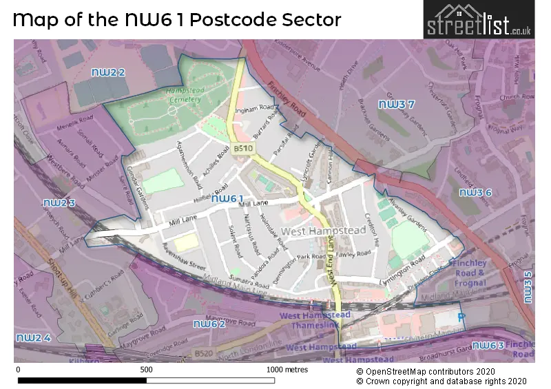
Map of the NW6 1 Postcode Sector
Explore the NW6 1 postcode sector by using our free interactive map.
| N | W | 6 | - | 1 | X | X |
| N | W | 6 | Space | 1 | Letter | Letter |
Official List of Streets
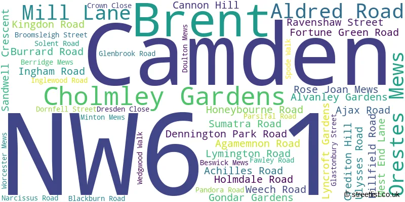
Camden (48 Streets)
Unofficial Streets or Alternative Spellings
Weather Forecast for NW6 1
Press Button to Show Forecast for Fenton House
| Time Period | Icon | Description | Temperature | Rain Probability | Wind |
|---|---|---|---|---|---|
| 06:00 to 09:00 | Cloudy | 9.0°C (feels like 7.0°C) | 54.00% | WNW 11 mph | |
| 09:00 to 12:00 | Light rain shower (day) | 10.0°C (feels like 7.0°C) | 36.00% | NW 16 mph | |
| 12:00 to 15:00 | Cloudy | 11.0°C (feels like 8.0°C) | 6.00% | NW 16 mph | |
| 15:00 to 18:00 | Overcast | 11.0°C (feels like 8.0°C) | 13.00% | N 13 mph | |
| 18:00 to 21:00 | Light rain | 9.0°C (feels like 6.0°C) | 45.00% | NNE 9 mph | |
| 21:00 to 00:00 | Cloudy | 7.0°C (feels like 4.0°C) | 6.00% | NNE 9 mph |
Press Button to Show Forecast for Fenton House
| Time Period | Icon | Description | Temperature | Rain Probability | Wind |
|---|---|---|---|---|---|
| 00:00 to 03:00 | Clear night | 5.0°C (feels like 2.0°C) | 1.00% | N 9 mph | |
| 03:00 to 06:00 | Partly cloudy (night) | 4.0°C (feels like 1.0°C) | 1.00% | NNW 9 mph | |
| 06:00 to 09:00 | Partly cloudy (day) | 4.0°C (feels like 0.0°C) | 2.00% | NNW 9 mph | |
| 09:00 to 12:00 | Cloudy | 7.0°C (feels like 3.0°C) | 5.00% | N 11 mph | |
| 12:00 to 15:00 | Overcast | 9.0°C (feels like 6.0°C) | 8.00% | N 11 mph | |
| 15:00 to 18:00 | Overcast | 10.0°C (feels like 7.0°C) | 9.00% | N 11 mph | |
| 18:00 to 21:00 | Cloudy | 9.0°C (feels like 7.0°C) | 5.00% | NNE 9 mph | |
| 21:00 to 00:00 | Partly cloudy (night) | 7.0°C (feels like 5.0°C) | 2.00% | NNE 7 mph |
Press Button to Show Forecast for Fenton House
| Time Period | Icon | Description | Temperature | Rain Probability | Wind |
|---|---|---|---|---|---|
| 00:00 to 03:00 | Cloudy | 5.0°C (feels like 4.0°C) | 6.00% | NNE 4 mph | |
| 03:00 to 06:00 | Cloudy | 5.0°C (feels like 3.0°C) | 5.00% | NNW 4 mph | |
| 06:00 to 09:00 | Overcast | 5.0°C (feels like 3.0°C) | 9.00% | N 7 mph | |
| 09:00 to 12:00 | Overcast | 7.0°C (feels like 5.0°C) | 13.00% | NNE 9 mph | |
| 12:00 to 15:00 | Overcast | 9.0°C (feels like 6.0°C) | 12.00% | NNE 11 mph | |
| 15:00 to 18:00 | Cloudy | 10.0°C (feels like 8.0°C) | 6.00% | NNE 11 mph | |
| 18:00 to 21:00 | Cloudy | 10.0°C (feels like 7.0°C) | 5.00% | NNE 11 mph | |
| 21:00 to 00:00 | Partly cloudy (night) | 7.0°C (feels like 5.0°C) | 2.00% | NNE 9 mph |
Press Button to Show Forecast for Fenton House
| Time Period | Icon | Description | Temperature | Rain Probability | Wind |
|---|---|---|---|---|---|
| 00:00 to 03:00 | Partly cloudy (night) | 6.0°C (feels like 3.0°C) | 2.00% | NNE 9 mph | |
| 03:00 to 06:00 | Partly cloudy (night) | 5.0°C (feels like 2.0°C) | 2.00% | NNE 9 mph | |
| 06:00 to 09:00 | Sunny day | 5.0°C (feels like 2.0°C) | 2.00% | NNE 9 mph | |
| 09:00 to 12:00 | Cloudy | 8.0°C (feels like 5.0°C) | 5.00% | NE 11 mph | |
| 12:00 to 15:00 | Cloudy | 10.0°C (feels like 7.0°C) | 8.00% | NE 11 mph | |
| 15:00 to 18:00 | Overcast | 10.0°C (feels like 8.0°C) | 11.00% | NE 11 mph | |
| 18:00 to 21:00 | Cloudy | 10.0°C (feels like 7.0°C) | 8.00% | NE 11 mph | |
| 21:00 to 00:00 | Partly cloudy (night) | 7.0°C (feels like 5.0°C) | 2.00% | NE 9 mph |
Schools and Places of Education Within the NW6 1 Postcode Sector
Emmanuel Church of England Primary School
Voluntary aided school
152-158 Mill Lane, London, , NW6 1TF
Head: Mrs Laura Hall
Ofsted Rating: Good
Inspection: 2019-01-16 (1920 days ago)
Website: Visit Emmanuel Church of England Primary School Website
Phone: 02074317984
Number of Pupils: 229
West Hampstead Primary School
Community school
Dornfell Street, London, , NW6 1QL
Head: Mr Samuel Drake
Ofsted Rating: Good
Inspection: 2022-03-23 (758 days ago)
Website: Visit West Hampstead Primary School Website
Phone: 02074358646
Number of Pupils: 389
House Prices in the NW6 1 Postcode Sector
| Type of Property | 2018 Average | 2018 Sales | 2017 Average | 2017 Sales | 2016 Average | 2016 Sales | 2015 Average | 2015 Sales |
|---|---|---|---|---|---|---|---|---|
| Detached | £3,750,000 | 2 | £0 | 0 | £2,215,000 | 2 | £4,500,000 | 1 |
| Semi-Detached | £2,016,786 | 7 | £1,380,000 | 3 | £2,918,625 | 4 | £2,312,500 | 2 |
| Terraced | £1,316,890 | 36 | £1,549,420 | 23 | £1,515,000 | 22 | £1,329,793 | 30 |
| Flats | £666,632 | 106 | £750,784 | 102 | £739,164 | 94 | £731,765 | 161 |
Important Postcodes NW6 1 in the Postcode Sector
NW6 1AU is the postcode for West Hampstead Library, Dennington Park Road, and London Borough of Camden, West Hampstead Library, Dennington Park Road
NW6 1DX is the postcode for West Hampstead Police Station, 21 Fortune Green Road, Metropolitan Police, West Hampstead Police Station, 21 Fortune Green Road, and WEST HAMPSTEAD POLICE STATION, Metropolitan Police, West Hampstead Police Station, 21 Fortune Green Road
NW6 1QL is the postcode for West Hampstead Primary School, Dornfell Street, and Beckford Primary School, Dornfell Street
NW6 1SD is the postcode for London Borough of Camden, 156 West End Lane
NW6 1TF is the postcode for Emmanuel C of E School, 152 Mill Lane, and Emmanuel Church of England School, 152-158 Mill Lane
NW6 1TP is the postcode for West Hampstead Medical Centre, 9 Solent Road
| The NW6 1 Sector is within these Local Authorities |
|
|---|---|
| The NW6 1 Sector is within these Counties |
|
| The NW6 1 Sector is within these Water Company Areas |
|