The NW6 2 postcode sector is within the county of Greater London.
Did you know? According to the 2021 Census, the NW6 2 postcode sector is home to a bustling 7,197 residents!
Given that each sector allows for 400 unique postcode combinations. Letters C, I, K, M, O and V are not allowed in the last two letters of a postcode. With 115 postcodes already in use, this leaves 285 units available.
The NW6 2 postal code covers the settlement of LONDON .
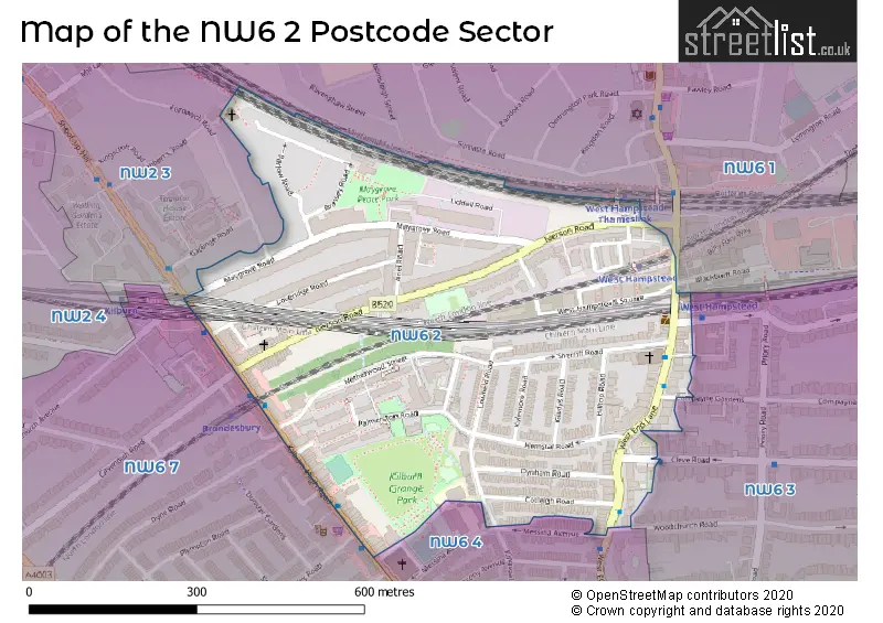
The NW6 2 Postcode shares a border with NW2 3 (LONDON , CRICKLEWOOD ), NW6 1 (LONDON ), NW6 3 (LONDON ), NW6 4 (LONDON ) and NW6 7 (LONDON , KILBURN ).
The sector is within the post town of LONDON.
NW6 2 is a postcode sector within the NW6 postcode district which is within the NW North West London postcode area.
The Royal Mail delivery office for the NW6 2 postal sector is the Kilburn Sdelivery Office.
The area of the NW6 2 postcode sector is 0.18 square miles which is 0.48 square kilometres or 118.15 square acres.


Map of the NW6 2 Postcode Sector
Explore the NW6 2 postcode sector by using our free interactive map.
| N | W | 6 | - | 2 | X | X |
| N | W | 6 | Space | 2 | Letter | Letter |
Official List of Streets
Camden (28 Streets)
Unofficial Streets or Alternative Spellings
Weather Forecast for NW6 2
Press Button to Show Forecast for Hampstead
| Time Period | Icon | Description | Temperature | Rain Probability | Wind |
|---|---|---|---|---|---|
| 06:00 to 09:00 | Partly cloudy (day) | 3.0°C (feels like 0.0°C) | 1.00% | NNW 9 mph | |
| 09:00 to 12:00 | Cloudy | 7.0°C (feels like 3.0°C) | 3.00% | N 13 mph | |
| 12:00 to 15:00 | Cloudy | 9.0°C (feels like 6.0°C) | 5.00% | N 11 mph | |
| 15:00 to 18:00 | Cloudy | 10.0°C (feels like 7.0°C) | 4.00% | N 11 mph | |
| 18:00 to 21:00 | Cloudy | 9.0°C (feels like 7.0°C) | 4.00% | NNE 9 mph | |
| 21:00 to 00:00 | Cloudy | 7.0°C (feels like 4.0°C) | 5.00% | NNE 7 mph |
Press Button to Show Forecast for Hampstead
| Time Period | Icon | Description | Temperature | Rain Probability | Wind |
|---|---|---|---|---|---|
| 00:00 to 03:00 | Cloudy | 5.0°C (feels like 3.0°C) | 5.00% | N 7 mph | |
| 03:00 to 06:00 | Cloudy | 5.0°C (feels like 2.0°C) | 4.00% | N 7 mph | |
| 06:00 to 09:00 | Cloudy | 5.0°C (feels like 2.0°C) | 5.00% | N 7 mph | |
| 09:00 to 12:00 | Overcast | 7.0°C (feels like 4.0°C) | 8.00% | NNE 11 mph | |
| 12:00 to 15:00 | Cloudy | 9.0°C (feels like 6.0°C) | 5.00% | NNE 11 mph | |
| 15:00 to 18:00 | Cloudy | 10.0°C (feels like 7.0°C) | 6.00% | NNE 13 mph | |
| 18:00 to 21:00 | Partly cloudy (day) | 9.0°C (feels like 6.0°C) | 3.00% | NNE 11 mph | |
| 21:00 to 00:00 | Clear night | 6.0°C (feels like 4.0°C) | 2.00% | NNE 9 mph |
Press Button to Show Forecast for Hampstead
| Time Period | Icon | Description | Temperature | Rain Probability | Wind |
|---|---|---|---|---|---|
| 00:00 to 03:00 | Clear night | 5.0°C (feels like 2.0°C) | 2.00% | NNE 7 mph | |
| 03:00 to 06:00 | Partly cloudy (night) | 4.0°C (feels like 1.0°C) | 2.00% | N 7 mph | |
| 06:00 to 09:00 | Sunny day | 4.0°C (feels like 1.0°C) | 2.00% | N 7 mph | |
| 09:00 to 12:00 | Cloudy | 8.0°C (feels like 6.0°C) | 6.00% | NNE 7 mph | |
| 12:00 to 15:00 | Cloudy | 9.0°C (feels like 7.0°C) | 8.00% | N 7 mph | |
| 15:00 to 18:00 | Overcast | 9.0°C (feels like 7.0°C) | 13.00% | NNW 9 mph | |
| 18:00 to 21:00 | Overcast | 8.0°C (feels like 6.0°C) | 15.00% | NNW 9 mph | |
| 21:00 to 00:00 | Light rain | 6.0°C (feels like 5.0°C) | 48.00% | N 7 mph |
Press Button to Show Forecast for Hampstead
| Time Period | Icon | Description | Temperature | Rain Probability | Wind |
|---|---|---|---|---|---|
| 00:00 to 03:00 | Light rain shower (night) | 5.0°C (feels like 4.0°C) | 37.00% | E 4 mph | |
| 03:00 to 06:00 | Cloudy | 5.0°C (feels like 3.0°C) | 13.00% | NNE 4 mph | |
| 06:00 to 09:00 | Partly cloudy (day) | 5.0°C (feels like 3.0°C) | 5.00% | NNE 7 mph | |
| 09:00 to 12:00 | Cloudy | 8.0°C (feels like 6.0°C) | 9.00% | NNE 9 mph | |
| 12:00 to 15:00 | Overcast | 10.0°C (feels like 8.0°C) | 16.00% | NNE 11 mph | |
| 15:00 to 18:00 | Overcast | 11.0°C (feels like 8.0°C) | 16.00% | NNE 11 mph | |
| 18:00 to 21:00 | Overcast | 10.0°C (feels like 8.0°C) | 10.00% | NE 9 mph | |
| 21:00 to 00:00 | Clear night | 7.0°C (feels like 5.0°C) | 6.00% | NNE 9 mph |
House Prices in the NW6 2 Postcode Sector
| Type of Property | 2018 Average | 2018 Sales | 2017 Average | 2017 Sales | 2016 Average | 2016 Sales | 2015 Average | 2015 Sales |
|---|---|---|---|---|---|---|---|---|
| Detached | £4,205,663 | 1 | £0 | 0 | £4,300,000 | 1 | £0 | 0 |
| Semi-Detached | £0 | 0 | £0 | 0 | £0 | 0 | £780,000 | 1 |
| Terraced | £1,390,000 | 4 | £1,005,000 | 5 | £1,305,556 | 9 | £988,296 | 9 |
| Flats | £593,934 | 76 | £695,994 | 219 | £645,697 | 176 | £576,349 | 73 |
Important Postcodes NW6 2 in the Postcode Sector
NW6 2DJ is the postcode for ADMIN/ CATERING, Kingsgate Primary School, Lower School, and TEACHING BLOCK, Kingsgate Primary School, Lower School
NW6 2JL is the postcode for KILBURN GRANGE CHILDREN'S CENTRE, London Borough of Camden, 1 Palmerston Road
NW6 2JU is the postcode for Kingsgate Resource Centre, 208 Webheath, Netherwood Street
NW6 2QU is the postcode for Camden & Islington Mental Health & Social Care Trust, Netherwood Day Centre, 5 Netherwood Street
| The NW6 2 Sector is within these Local Authorities |
|
|---|---|
| The NW6 2 Sector is within these Counties |
|
| The NW6 2 Sector is within these Water Company Areas |
|