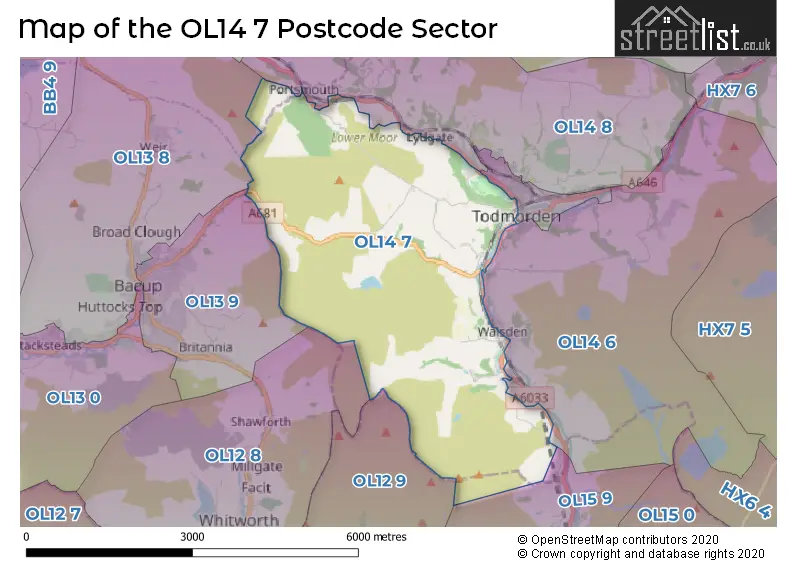
The OL14 7 postcode sector lies where the three counties of Lancashire, West Yorkshire, and Greater Manchester meet.
Did you know? According to the 2021 Census, the OL14 7 postcode sector is home to a bustling 3,097 residents!
Given that each sector allows for 400 unique postcode combinations. Letters C, I, K, M, O and V are not allowed in the last two letters of a postcode. With 178 postcodes already in use, this leaves 222 units available.
The OL14 7 postal code covers the settlement of TODMORDEN.
The OL14 7 Postcode shares a border with OL13 9 (BACUP, Britannia), OL14 5 (TODMORDEN), OL15 9 (LITTLEBOROUGH), OL13 8 (BACUP), OL14 8 (TODMORDEN), OL12 8 (Whitworth, Shawforth, Facit), OL12 9 (ROCHDALE, Wardle) and OL14 6 (TODMORDEN, Walsden).
The sector is within the post town of TODMORDEN.
OL14 7 is a postcode sector within the OL14 postcode district which is within the OL Oldham postcode area.
The Royal Mail delivery office for the OL14 7 postal sector is the Todmorden Delivery Office.
The area of the OL14 7 postcode sector is 8.86 square miles which is 22.94 square kilometres or 5,668.32 square acres.
Waterways within the OL14 7 postcode sector include the Rochdale Canal, 19 Todmorden Lock, 20 Wadsworth Mill Lock, 21 Shade Lock, 22 Gauxholme Lowest Lock, 23 Gauxholme Middle Lock, 24 Gauxholme Highest Lock, 36 Longlees Lock.

Map of the OL14 7 Postcode Sector
Explore the OL14 7 postcode sector by using our free interactive map.
| O | L | 1 | 4 | - | 7 | X | X |
| O | L | 1 | 4 | Space | 7 | Letter | Letter |
Official List of Streets
TODMORDEN (109 Streets)
Cornholme (1 Streets)
Unofficial Streets or Alternative Spellings
TODMORDEN
BESWICK STREET BOBBIN MILL CLOSE BOTTOMLEY ROAD BROWN BIRKS STREET DAISY BANK STREET HALIFAX ROAD HOLLINS ROAD LENNOX ROAD MOUNT PLEASANT OXFORD STREET PARKSIDE ROAD RAKE HEAD BARN LANE VICARAGE GARDENS WATER STREET BACK RIDGE STREET BARNES STREET CANNON STREET CLOUGH MILL CLOUGH ROAD DURN STREET FIRWOOD CLOSE HACKING LANE HUNTERS LANE LIMERS GATE LITTLEHOLME STREET LONG CAUSEWAY LOVERS WALK MONKS HOUSE RIDE OAK STREET PEAR PLACE PEAR STREET PEEL COTT STREET PENINE BRIDLEWAY PIONEER STREET RAMSDEN STREET REDDYSHORE SCOUT GATE ROCHDALE WAY ROSSENDALE WAY SIGGET LANE STATION APPROACH STRINES LANE STUBLEY LANE TCW TODMORDEN CENTENARY WAY TOP OTH CLOSE ROAD VERNON STREETBACUP
TODMORDEN ROADWalsden
ROCHDALE ROADCliviger
BURNLEY ROADWeather Forecast for OL14 7
Press Button to Show Forecast for Todmorden
| Time Period | Icon | Description | Temperature | Rain Probability | Wind |
|---|---|---|---|---|---|
| 09:00 to 12:00 | Cloudy | 6.0°C (feels like 3.0°C) | 47.00% | N 9 mph | |
| 12:00 to 15:00 | Light rain shower (day) | 8.0°C (feels like 6.0°C) | 35.00% | NE 4 mph | |
| 15:00 to 18:00 | Cloudy | 9.0°C (feels like 7.0°C) | 8.00% | ENE 7 mph | |
| 18:00 to 21:00 | Cloudy | 7.0°C (feels like 6.0°C) | 10.00% | ESE 4 mph | |
| 21:00 to 00:00 | Cloudy | 5.0°C (feels like 3.0°C) | 5.00% | NE 7 mph |
Press Button to Show Forecast for Todmorden
| Time Period | Icon | Description | Temperature | Rain Probability | Wind |
|---|---|---|---|---|---|
| 00:00 to 03:00 | Clear night | 3.0°C (feels like 1.0°C) | 2.00% | ENE 4 mph | |
| 03:00 to 06:00 | Clear night | 1.0°C (feels like -1.0°C) | 1.00% | NE 4 mph | |
| 06:00 to 09:00 | Sunny day | 2.0°C (feels like 0.0°C) | 1.00% | ENE 4 mph | |
| 09:00 to 12:00 | Cloudy | 7.0°C (feels like 5.0°C) | 4.00% | ENE 4 mph | |
| 12:00 to 15:00 | Overcast | 8.0°C (feels like 7.0°C) | 9.00% | E 4 mph | |
| 15:00 to 18:00 | Cloudy | 10.0°C (feels like 9.0°C) | 6.00% | E 4 mph | |
| 18:00 to 21:00 | Cloudy | 9.0°C (feels like 8.0°C) | 6.00% | ENE 4 mph | |
| 21:00 to 00:00 | Partly cloudy (night) | 6.0°C (feels like 3.0°C) | 4.00% | ENE 7 mph |
Press Button to Show Forecast for Todmorden
| Time Period | Icon | Description | Temperature | Rain Probability | Wind |
|---|---|---|---|---|---|
| 00:00 to 03:00 | Partly cloudy (night) | 4.0°C (feels like 1.0°C) | 5.00% | ENE 4 mph | |
| 03:00 to 06:00 | Partly cloudy (night) | 3.0°C (feels like 1.0°C) | 5.00% | ENE 4 mph | |
| 06:00 to 09:00 | Partly cloudy (day) | 4.0°C (feels like 2.0°C) | 5.00% | ENE 7 mph | |
| 09:00 to 12:00 | Cloudy | 8.0°C (feels like 6.0°C) | 7.00% | E 7 mph | |
| 12:00 to 15:00 | Overcast | 10.0°C (feels like 8.0°C) | 14.00% | E 9 mph | |
| 15:00 to 18:00 | Cloudy | 10.0°C (feels like 8.0°C) | 17.00% | E 9 mph | |
| 18:00 to 21:00 | Cloudy | 9.0°C (feels like 7.0°C) | 15.00% | ENE 9 mph | |
| 21:00 to 00:00 | Cloudy | 7.0°C (feels like 4.0°C) | 15.00% | ENE 9 mph |
Press Button to Show Forecast for Todmorden
| Time Period | Icon | Description | Temperature | Rain Probability | Wind |
|---|---|---|---|---|---|
| 00:00 to 03:00 | Cloudy | 6.0°C (feels like 3.0°C) | 13.00% | NE 9 mph | |
| 03:00 to 06:00 | Cloudy | 6.0°C (feels like 3.0°C) | 15.00% | NE 11 mph | |
| 06:00 to 09:00 | Light rain | 6.0°C (feels like 3.0°C) | 49.00% | NE 11 mph | |
| 09:00 to 12:00 | Light rain | 7.0°C (feels like 4.0°C) | 52.00% | NNE 11 mph | |
| 12:00 to 15:00 | Heavy rain | 9.0°C (feels like 6.0°C) | 76.00% | NNE 9 mph | |
| 15:00 to 18:00 | Heavy rain | 9.0°C (feels like 7.0°C) | 75.00% | NNE 9 mph | |
| 18:00 to 21:00 | Light rain shower (day) | 10.0°C (feels like 8.0°C) | 39.00% | NNW 7 mph | |
| 21:00 to 00:00 | Partly cloudy (night) | 7.0°C (feels like 5.0°C) | 12.00% | NW 7 mph |
Schools and Places of Education Within the OL14 7 Postcode Sector
Shade Primary School
Community school
Knowlwood Road, Todmorden, West Yorkshire, OL14 7PD
Head: Miss Mollie McCracken
Ofsted Rating: Good
Inspection: 2023-05-11 (350 days ago)
Website: Visit Shade Primary School Website
Phone: 01706812913
Number of Pupils: 202
Todmorden CofE J, I & N School
Voluntary aided school
Burnley Road, Todmorden, Lancashire, OL14 7BS
Head: Mrs Alice Leadbitter
Ofsted Rating: Good
Inspection: 2022-07-07 (658 days ago)
Website: Visit Todmorden CofE J, I & N School Website
Phone: 01706812019
Number of Pupils: 254
Todmorden High School
Community school
Ewood Lane, Todmorden, West Yorkshire, OL14 7DG
Head: Miss Gill Shirt
Ofsted Rating: Good
Inspection: 2020-01-23 (1554 days ago)
Website: Visit Todmorden High School Website
Phone: 01706813558
Number of Pupils: 887
House Prices in the OL14 7 Postcode Sector
| Type of Property | 2018 Average | 2018 Sales | 2017 Average | 2017 Sales | 2016 Average | 2016 Sales | 2015 Average | 2015 Sales |
|---|---|---|---|---|---|---|---|---|
| Detached | £301,375 | 8 | £301,071 | 7 | £308,807 | 7 | £282,125 | 8 |
| Semi-Detached | £243,086 | 11 | £189,244 | 8 | £174,585 | 13 | £169,905 | 18 |
| Terraced | £130,266 | 28 | £130,524 | 40 | £136,760 | 20 | £104,821 | 31 |
| Flats | £0 | 0 | £237,500 | 2 | £85,000 | 1 | £78,000 | 1 |
Important Postcodes OL14 7 in the Postcode Sector
OL14 7BS is the postcode for MAIN SCHOOL, Todmorden C of E Junior & Infant School, Burnley Road, NURSERY BUILDING, Todmorden C of E Junior & Infant School, Burnley Road, and Todmorden C of E Junior & Infant School, Burnley Road
OL14 7BX is the postcode for Todmorden Community College, Burnley Road
OL14 7DF is the postcode for Todmorden Sports Centre, Ewood Lane, and TODMORDEN SPORTS CENTRE, EWOOD LANE, TODMORDEN
OL14 7DG is the postcode for MAIN BLOCK, Todmorden High School, Ewood Lane, WORLD STUDIES BLOCK, Todmorden High School, Ewood Lane, Todmorden High School, Ewood Lane, and NEW ENGLISH & HUMANITIES BLOCK, Todmorden High School, Ewood Lane
OL14 7LB is the postcode for Todmorden Library, Rochdale Road, and Calderdale Metropolitan Borough Council, Todmorden Library, Rochdale Road
OL14 7PD is the postcode for Shade Primary School, Rochdale Road, and SHADE PRIMARY SCHOOL, ROCHDALE ROAD, TODMORDEN
| The OL14 7 Sector is within these Local Authorities |
|
|---|---|
| The OL14 7 Sector is within these Counties |
|
| The OL14 7 Sector is within these Water Company Areas |
|