The OL15 8 postcode sector is within the county of Greater Manchester.
Did you know? According to the 2021 Census, the OL15 8 postcode sector is home to a bustling 5,695 residents!
Given that each sector allows for 400 unique postcode combinations. Letters C, I, K, M, O and V are not allowed in the last two letters of a postcode. With 205 postcodes already in use, this leaves 195 units available.
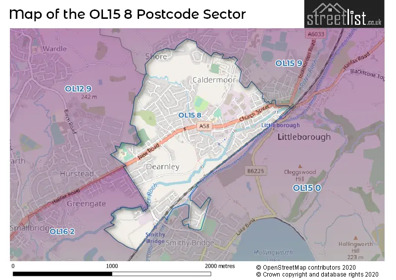
The OL15 8 postal code covers the settlement of LITTLEBOROUGH.
The OL15 8 Postcode shares a border with OL15 9 (LITTLEBOROUGH), OL15 0 (LITTLEBOROUGH), OL12 9 (ROCHDALE, Wardle) and OL16 2 (ROCHDALE, Hurstead).
The sector is within the post town of LITTLEBOROUGH.
OL15 8 is a postcode sector within the OL15 postcode district which is within the OL Oldham postcode area.
The Royal Mail delivery office for the OL15 8 postal sector is the Rochdale Delivery Office.
The area of the OL15 8 postcode sector is 0.72 square miles which is 1.87 square kilometres or 461.58 square acres.
Waterways within the OL15 8 postcode sector include the Rochdale Canal.

Map of the OL15 8 Postcode Sector
Explore the OL15 8 postcode sector by using our free interactive map.
| O | L | 1 | 5 | - | 8 | X | X |
| O | L | 1 | 5 | Space | 8 | Letter | Letter |
Official List of Streets
LITTLEBOROUGH (153 Streets)
Shore (1 Streets)
Unofficial Streets or Alternative Spellings
LITTLEBOROUGH
ABBEY DRIVE ABERLEY FOLD BROWN LODGE DRIVE BROWN LODGE STREET COTE LANE DIVIDEND DRIVE ERIC STREET HARE HILL ROAD HENRY STREET LINCOLN DRIVE SALE STREET BOUNDARY STREET CLAY STREET CROWTHER STREET DYERS COURT FLETCHERS ROAD HEBER PLACE JOHN STREET KING STREET ORRON STREET SAINT BARNABASS DRIVE SAWMILL WAY ST BARNABASS DRIVE VALE COTTAGES WATLING STREET WOOD BANK ROADROCHDALE
HALIFAX ROAD OLD ROAD SOUTH VIEW ROAD UNION ROADLITTLEBOROUGH,
SMITHY BRIDGE ROADWardle
OAKHURST CLOSEWeather Forecast for OL15 8
Press Button to Show Forecast for Shore
| Time Period | Icon | Description | Temperature | Rain Probability | Wind |
|---|---|---|---|---|---|
| 12:00 to 15:00 | Overcast | 8.0°C (feels like 6.0°C) | 8.00% | NNE 7 mph | |
| 15:00 to 18:00 | Cloudy | 10.0°C (feels like 9.0°C) | 5.00% | NNE 4 mph | |
| 18:00 to 21:00 | Partly cloudy (day) | 8.0°C (feels like 5.0°C) | 4.00% | NW 11 mph | |
| 21:00 to 00:00 | Cloudy | 5.0°C (feels like 3.0°C) | 3.00% | WNW 7 mph |
Press Button to Show Forecast for Shore
| Time Period | Icon | Description | Temperature | Rain Probability | Wind |
|---|---|---|---|---|---|
| 00:00 to 03:00 | Partly cloudy (night) | 4.0°C (feels like 3.0°C) | 0.00% | WSW 4 mph | |
| 03:00 to 06:00 | Cloudy | 4.0°C (feels like 2.0°C) | 4.00% | WSW 4 mph | |
| 06:00 to 09:00 | Light rain shower (day) | 5.0°C (feels like 2.0°C) | 37.00% | WNW 7 mph | |
| 09:00 to 12:00 | Light rain | 7.0°C (feels like 4.0°C) | 42.00% | NW 9 mph | |
| 12:00 to 15:00 | Light rain | 6.0°C (feels like 4.0°C) | 52.00% | NNE 7 mph | |
| 15:00 to 18:00 | Cloudy | 8.0°C (feels like 7.0°C) | 8.00% | NNW 4 mph | |
| 18:00 to 21:00 | Cloudy | 6.0°C (feels like 4.0°C) | 14.00% | NNE 9 mph | |
| 21:00 to 00:00 | Cloudy | 4.0°C (feels like 2.0°C) | 5.00% | ENE 7 mph |
Press Button to Show Forecast for Shore
| Time Period | Icon | Description | Temperature | Rain Probability | Wind |
|---|---|---|---|---|---|
| 00:00 to 03:00 | Partly cloudy (night) | 2.0°C (feels like 0.0°C) | 1.00% | NE 4 mph | |
| 03:00 to 06:00 | Clear night | 1.0°C (feels like -2.0°C) | 1.00% | NNE 4 mph | |
| 06:00 to 09:00 | Sunny day | 2.0°C (feels like 0.0°C) | 1.00% | NE 4 mph | |
| 09:00 to 12:00 | Cloudy | 5.0°C (feels like 3.0°C) | 8.00% | ENE 7 mph | |
| 12:00 to 15:00 | Overcast | 7.0°C (feels like 5.0°C) | 9.00% | ENE 7 mph | |
| 15:00 to 18:00 | Cloudy | 8.0°C (feels like 7.0°C) | 6.00% | E 4 mph | |
| 18:00 to 21:00 | Cloudy | 7.0°C (feels like 5.0°C) | 6.00% | E 7 mph | |
| 21:00 to 00:00 | Partly cloudy (night) | 4.0°C (feels like 1.0°C) | 3.00% | E 7 mph |
Press Button to Show Forecast for Shore
| Time Period | Icon | Description | Temperature | Rain Probability | Wind |
|---|---|---|---|---|---|
| 00:00 to 03:00 | Partly cloudy (night) | 3.0°C (feels like 0.0°C) | 4.00% | E 4 mph | |
| 03:00 to 06:00 | Cloudy | 3.0°C (feels like 0.0°C) | 7.00% | ENE 4 mph | |
| 06:00 to 09:00 | Cloudy | 3.0°C (feels like 1.0°C) | 9.00% | ENE 7 mph | |
| 09:00 to 12:00 | Cloudy | 6.0°C (feels like 3.0°C) | 9.00% | E 9 mph | |
| 12:00 to 15:00 | Overcast | 8.0°C (feels like 6.0°C) | 14.00% | E 9 mph | |
| 15:00 to 18:00 | Overcast | 9.0°C (feels like 6.0°C) | 18.00% | E 11 mph | |
| 18:00 to 21:00 | Cloudy | 8.0°C (feels like 5.0°C) | 15.00% | ENE 11 mph | |
| 21:00 to 00:00 | Cloudy | 5.0°C (feels like 2.0°C) | 15.00% | ENE 9 mph |
Press Button to Show Forecast for Shore
| Time Period | Icon | Description | Temperature | Rain Probability | Wind |
|---|---|---|---|---|---|
| 00:00 to 03:00 | Cloudy | 4.0°C (feels like 1.0°C) | 15.00% | NE 9 mph | |
| 03:00 to 06:00 | Overcast | 4.0°C (feels like 1.0°C) | 18.00% | NE 11 mph | |
| 06:00 to 09:00 | Light rain | 5.0°C (feels like 2.0°C) | 50.00% | NE 11 mph | |
| 09:00 to 12:00 | Heavy rain | 6.0°C (feels like 3.0°C) | 75.00% | NE 11 mph | |
| 12:00 to 15:00 | Heavy rain | 8.0°C (feels like 5.0°C) | 76.00% | NE 11 mph | |
| 15:00 to 18:00 | Heavy rain | 8.0°C (feels like 5.0°C) | 74.00% | NNW 9 mph | |
| 18:00 to 21:00 | Light rain shower (day) | 8.0°C (feels like 6.0°C) | 38.00% | NW 9 mph | |
| 21:00 to 00:00 | Clear night | 6.0°C (feels like 4.0°C) | 11.00% | N 7 mph |
Schools and Places of Education Within the OL15 8 Postcode Sector
St Mary's Roman Catholic Primary School, Littleborough
Voluntary aided school
Whitelees Road, Littleborough, Lancashire, OL15 8DU
Head: Mrs Carmel Ruane
Ofsted Rating: Good
Inspection: 2021-11-25 (881 days ago)
Website: Visit St Mary's Roman Catholic Primary School, Littleborough Website
Phone: 01706378032
Number of Pupils: 219
House Prices in the OL15 8 Postcode Sector
| Type of Property | 2018 Average | 2018 Sales | 2017 Average | 2017 Sales | 2016 Average | 2016 Sales | 2015 Average | 2015 Sales |
|---|---|---|---|---|---|---|---|---|
| Detached | £241,109 | 22 | £229,704 | 24 | £238,529 | 24 | £176,818 | 11 |
| Semi-Detached | £154,445 | 31 | £149,247 | 29 | £135,385 | 24 | £123,942 | 27 |
| Terraced | £117,333 | 57 | £114,426 | 51 | £107,097 | 38 | £100,624 | 34 |
| Flats | £100,938 | 8 | £91,498 | 9 | £99,167 | 3 | £115,375 | 4 |
Important Postcodes OL15 8 in the Postcode Sector
OL15 8DU is the postcode for St Marys RC Primary School, Whitelees Road, and Greater Manchester Fire & Rescue Service, Fire Station, Whitelees Road
OL15 8HF is the postcode for Littleborough Health Centre, Featherstall Road
| The OL15 8 Sector is within these Local Authorities |
|
|---|---|
| The OL15 8 Sector is within these Counties |
|
| The OL15 8 Sector is within these Water Company Areas |
|