The OX18 postcode district is a postal district located in the OX Oxford postcode area with a population of 27,607 residents according to the 2021 England and Wales Census.
The area of the OX18 postcode district is 63.61 square miles which is 164.75 square kilometres or 40,710.17 acres.
Currently, the OX18 district has about 878 postcode units spread across 4 geographic postcode sectors.
Given that each sector allows for 400 unique postcode combinations, the district has a capacity of 1,600 postcodes. With 878 postcodes already in use, this leaves 722 units available.
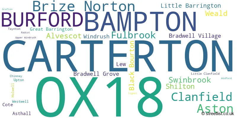
The largest settlement in the OX18 postal code is CARTERTON followed by BAMPTON, and BURFORD.
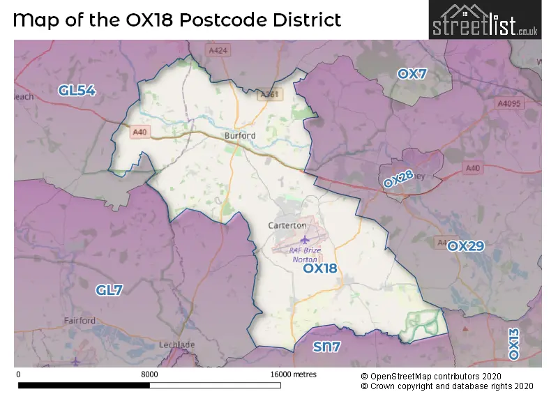
The OX18 Postcode shares a border with OX7 (CHIPPING NORTON, Charlbury, Milton-under-Wychwood), GL7 (CIRENCESTER, South Cerney, FAIRFORD), SN7 (FARINGDON, Stanford In The Vale, Uffington), OX29 (Eynsham, Long Hanborough, WITNEY) and GL54 (Winchcombe, Bourton-on-the-Water, Stow On The Wold).
The primary settlement in the OX18 postcode district is Carterton, which is located in Oxfordshire, England. Other significant settlements in this district include Brize Norton, Bampton, and Burford, all of which are also located in Oxfordshire.
For the district OX18, we have data on 5 postcode sectors. Here's a breakdown: The sector OX18 1, covers Carterton in Oxfordshire. The sector OX18 2, covers Bampton and Aston and Clanfield in Oxfordshire. The sector OX18 3, covers Carterton and Brize Norton in Oxfordshire. The sector OX18 4, covers Burford and Fulbrook in Oxfordshire. The sector OX18 9 is non-geographic. It's often designated for PO Boxes, large organisations, or special services.

Map of the OX18 Postcode District
Explore the OX18 postcode district by using our free interactive map.
When it comes to local government, postal geography often disregards political borders. However, for a breakdown in the OX18 District: the district mostly encompasses the West Oxfordshire District (896 postcodes), and finally, the Cotswold District area (24 postcodes).
Recent House Sales in OX18
| Date | Price | Address |
|---|---|---|
| 06/10/2023 | £212,500 | Butlers Drive, Carterton, OX18 3FQ |
| 02/10/2023 | £580,000 | Upper End, Fulbrook, Burford, OX18 4BX |
| 29/09/2023 | £250,000 | Mayfield Close, Carterton, OX18 3QS |
| 25/09/2023 | £452,500 | North Street, Aston, Bampton, OX18 2DJ |
| 25/09/2023 | £383,000 | Carmello Close, Carterton, OX18 1DJ |
| 25/09/2023 | £470,000 | Saxel Close, Aston, Bampton, OX18 2EB |
| 14/09/2023 | £545,000 | Tannery Gardens, Bampton, OX18 2FQ |
| 14/09/2023 | £750,000 | Station Road, Alvescot, Bampton, OX18 2PS |
| 14/09/2023 | £1,400,000 | Bampton Road, Clanfield, Bampton, OX18 2RG |
| 12/09/2023 | £370,000 | Magnolia Way, Carterton, OX18 1JJ |
Weather Forecast for OX18
Press Button to Show Forecast for Brize Norton
| Time Period | Icon | Description | Temperature | Rain Probability | Wind |
|---|---|---|---|---|---|
| 18:00 to 21:00 | Cloudy | 9.0°C (feels like 8.0°C) | 47.00% | NE 7 mph | |
| 21:00 to 00:00 | Cloudy | 7.0°C (feels like 5.0°C) | 5.00% | ENE 4 mph |
Press Button to Show Forecast for Brize Norton
| Time Period | Icon | Description | Temperature | Rain Probability | Wind |
|---|---|---|---|---|---|
| 00:00 to 03:00 | Cloudy | 6.0°C (feels like 4.0°C) | 5.00% | ENE 4 mph | |
| 03:00 to 06:00 | Cloudy | 4.0°C (feels like 2.0°C) | 4.00% | ENE 4 mph | |
| 06:00 to 09:00 | Cloudy | 4.0°C (feels like 1.0°C) | 6.00% | ENE 4 mph | |
| 09:00 to 12:00 | Cloudy | 7.0°C (feels like 5.0°C) | 6.00% | ENE 7 mph | |
| 12:00 to 15:00 | Overcast | 10.0°C (feels like 9.0°C) | 12.00% | ENE 7 mph | |
| 15:00 to 18:00 | Overcast | 11.0°C (feels like 10.0°C) | 15.00% | ENE 7 mph | |
| 18:00 to 21:00 | Cloudy | 10.0°C (feels like 9.0°C) | 13.00% | ENE 7 mph | |
| 21:00 to 00:00 | Cloudy | 7.0°C (feels like 5.0°C) | 13.00% | ENE 4 mph |
Press Button to Show Forecast for Brize Norton
| Time Period | Icon | Description | Temperature | Rain Probability | Wind |
|---|---|---|---|---|---|
| 00:00 to 03:00 | Cloudy | 5.0°C (feels like 3.0°C) | 13.00% | ENE 4 mph | |
| 03:00 to 06:00 | Cloudy | 4.0°C (feels like 2.0°C) | 14.00% | ENE 4 mph | |
| 06:00 to 09:00 | Overcast | 5.0°C (feels like 2.0°C) | 20.00% | ENE 4 mph | |
| 09:00 to 12:00 | Overcast | 8.0°C (feels like 5.0°C) | 23.00% | ENE 9 mph | |
| 12:00 to 15:00 | Overcast | 11.0°C (feels like 8.0°C) | 24.00% | ENE 9 mph | |
| 15:00 to 18:00 | Overcast | 12.0°C (feels like 10.0°C) | 22.00% | ENE 9 mph | |
| 18:00 to 21:00 | Cloudy | 11.0°C (feels like 9.0°C) | 24.00% | ENE 9 mph | |
| 21:00 to 00:00 | Heavy rain | 9.0°C (feels like 6.0°C) | 73.00% | NE 9 mph |
Press Button to Show Forecast for Brize Norton
| Time Period | Icon | Description | Temperature | Rain Probability | Wind |
|---|---|---|---|---|---|
| 00:00 to 03:00 | Heavy rain | 8.0°C (feels like 5.0°C) | 74.00% | NE 9 mph | |
| 03:00 to 06:00 | Heavy rain | 7.0°C (feels like 5.0°C) | 76.00% | NE 7 mph | |
| 06:00 to 09:00 | Heavy rain | 8.0°C (feels like 5.0°C) | 75.00% | NE 7 mph | |
| 09:00 to 12:00 | Light rain | 10.0°C (feels like 8.0°C) | 50.00% | NNE 7 mph | |
| 12:00 to 15:00 | Light rain shower (day) | 11.0°C (feels like 9.0°C) | 44.00% | W 9 mph | |
| 15:00 to 18:00 | Light rain shower (day) | 11.0°C (feels like 9.0°C) | 45.00% | W 11 mph | |
| 18:00 to 21:00 | Light rain shower (day) | 11.0°C (feels like 8.0°C) | 37.00% | W 9 mph | |
| 21:00 to 00:00 | Cloudy | 8.0°C (feels like 7.0°C) | 7.00% | WSW 4 mph |
Where is the OX18 Postcode District?
The postcode district OX18 is located in Carterton, a town in Oxfordshire. It is situated in close proximity to several nearby towns. To the North West, there is Burford, which is approximately 2.07 miles away. Bampton is located to the South East at a distance of 4.03 miles. Witney is positioned to the East and is about 5.53 miles away. Faringdon is situated to the South with a distance of 7.24 miles. Fairford is found to the South West and is around 8.32 miles away. Woodstock is located to the North East at a distance of 12.07 miles. Chipping Norton is positioned to the North and is approximately 12.31 miles away. Furthermore, the postcode district OX18 is around 66.22 miles away from the center of London.
The district covers the post towns of BAMPTON, BURFORD, CARTERTON.
The sector has postcodes within the nation of England.
The OX18 Postcode District is covers the following regions.
- Oxfordshire - Berkshire, Buckinghamshire and Oxfordshire - South East (England)
- Gloucestershire - Gloucestershire, Wiltshire and Bath/Bristol area - South West (England)
| Postcode Sector | Delivery Office |
|---|---|
| OX18 1 | Carterton Delivery Office |
| OX18 2 | Carterton Delivery Office |
| OX18 3 | Carterton Delivery Office |
| OX18 4 | Carterton Delivery Office |
| O | X | 1 | 8 | - | X | X | X |
| O | X | 1 | 8 | Space | Numeric | Letter | Letter |
Tourist Attractions within the Postcode Area
We found 2 visitor attractions within the OX18 postcode area
| Cotswold Wildlife Park & Gardens |
|---|
| Wildlife |
| Safari Park / Zoo / Aquarium / Aviary |
| View Cotswold Wildlife Park & Gardens on Google Maps |
| Tolsey Museum |
| Museums & Art Galleries |
| Museum and / or Art Gallery |
| View Tolsey Museum on Google Maps |
Current Monthly Rental Prices
| # Bedrooms | Min Price | Max Price | Avg Price |
|---|---|---|---|
| 1 | £758 | £1,400 | £1,015 |
| 2 | £883 | £1,950 | £1,207 |
| 3 | £1,450 | £3,850 | £2,033 |
| 4 | £1,550 | £3,200 | £2,500 |
| 5 | £9,950 | £9,950 | £9,950 |
Current House Prices
| # Bedrooms | Min Price | Max Price | Avg Price |
|---|---|---|---|
| £129,000 | £5,150,000 | £1,251,800 | |
| 1 | £135,000 | £275,000 | £184,375 |
| 2 | £110,000 | £750,000 | £345,981 |
| 3 | £126,000 | £1,195,000 | £386,944 |
| 4 | £325,000 | £1,950,000 | £644,326 |
| 5 | £400,000 | £3,100,000 | £1,255,769 |
| 6 | £800,000 | £3,250,000 | £1,950,000 |
Estate Agents who Operate in the OX18 District
| Logo | Name | Brand Name | Address | Contact Number | Total Properties |
|---|---|---|---|---|---|
 | Carterton | David Richings Estate Agents | 2 Streatfield House, Alvescot Road, Carterton, OX18 3XZ | 01993 843846 | 23 |
 | Carterton | Chancellors | Black Bourton Road, Carterton, OX18 3DN | 01993 225906 | 21 |
 | Carterton | Connells | Unit 2, Falklands House, Black Bourton Road, Carterton, OX18 3DN | 01993 225854 | 19 |
 | Burford | Tayler & Fletcher | 49 High Street, Burford, OX18 4QA | 01993 225821 | 10 |
 | Carterton | David Richings Estate Agents | 2 Streatfield House Alvescot Road, Carterton, OX18 3XZ | 01993 843846 | 9 |
| Type of Property | 2018 Average | 2018 Sales | 2017 Average | 2017 Sales | 2016 Average | 2016 Sales | 2015 Average | 2015 Sales |
|---|---|---|---|---|---|---|---|---|
| Detached | £534,640 | 170 | £487,098 | 145 | £469,501 | 151 | £484,727 | 141 |
| Semi-Detached | £323,808 | 156 | £320,176 | 156 | £322,659 | 115 | £295,721 | 110 |
| Terraced | £293,217 | 90 | £284,987 | 91 | £258,703 | 149 | £260,407 | 130 |
| Flats | £161,936 | 39 | £186,663 | 42 | £179,749 | 68 | £157,521 | 85 |