The OX20 postcode district is a postal district located in the OX Oxford postcode area with a population of 5,384 residents according to the 2021 England and Wales Census.
The area of the OX20 postcode district is 18.94 square miles which is 49.05 square kilometres or 12,119.74 acres.
Currently, the OX20 district has about 262 postcode units spread across 1 geographic postcode sectors.
Given that each sector allows for 400 unique postcode combinations, the district has a capacity of 400 postcodes. With 262 postcodes already in use, this leaves 138 units available.
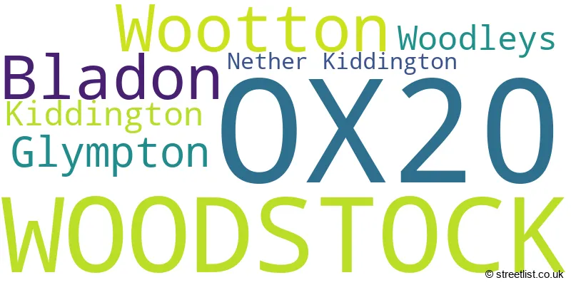
The largest settlement in the OX20 postal code is WOODSTOCK followed by Bladon, and Wootton.
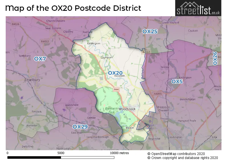
The OX20 Postcode shares a border with OX25 (Upper Heyford, Ambrosden, Weston-on-the-Green), OX7 (CHIPPING NORTON, Charlbury, Milton-under-Wychwood), OX5 (KIDLINGTON, Yarnton, Kirtlington) and OX29 (Eynsham, Long Hanborough, WITNEY).
In the OX20 postcode district, Woodstock is the primary settlement with the highest count. Other significant settlements in this district include Bladon, Glympton, Kiddington, Nether Kiddington, Woodleys, and Wootton. The post town for this district is Woodstock, located in the county of Oxfordshire, England.
For the district OX20, we have data on 1 postcode sectors. Here's a breakdown: The sector OX20 1, covers Woodstock and Wootton and Bladon in Oxfordshire.
OX20 Postcode Sectors

Map of the OX20 Postcode District
Explore the OX20 postcode district by using our free interactive map.
When it comes to local government, postal geography often disregards political borders. However, for a breakdown in the OX20 District: the district mostly encompasses the West Oxfordshire District (263 postcodes), and finally, the Cherwell District area (9 postcodes).
Recent House Sales in OX20
| Date | Price | Address |
|---|---|---|
| 02/10/2023 | £284,444 | Pitt Lane, Woodstock, OX20 1GL |
| 14/09/2023 | £1,140,000 | Grove Road, Bladon, Woodstock, OX20 1RJ |
| 05/09/2023 | £1,500,000 | Oxford Street, Woodstock, OX20 1TT |
| 01/09/2023 | £801,000 | Hedge End, Woodstock, OX20 1NP |
| 30/08/2023 | £425,000 | Rosamund Drive, Woodstock, OX20 1YD |
| 11/08/2023 | £500,000 | Randolph Avenue, Woodstock, OX20 1FG |
| 03/08/2023 | £335,000 | Lamb Lane, Bladon, Woodstock, OX20 1RP |
| 01/08/2023 | £325,000 | Shipton Road, Woodstock, OX20 1JN |
| 28/07/2023 | £460,000 | Castle Road, Wootton, Woodstock, OX20 1EQ |
| 18/07/2023 | £775,000 | Green Lane, Woodstock, OX20 1JZ |
Weather Forecast for OX20
Press Button to Show Forecast for Woodstock
| Time Period | Icon | Description | Temperature | Rain Probability | Wind |
|---|---|---|---|---|---|
| 06:00 to 09:00 | Partly cloudy (day) | 4.0°C (feels like 3.0°C) | 1.00% | W 4 mph | |
| 09:00 to 12:00 | Overcast | 8.0°C (feels like 6.0°C) | 8.00% | W 9 mph | |
| 12:00 to 15:00 | Light rain | 9.0°C (feels like 7.0°C) | 50.00% | W 9 mph | |
| 15:00 to 18:00 | Cloudy | 10.0°C (feels like 8.0°C) | 14.00% | WNW 7 mph | |
| 18:00 to 21:00 | Cloudy | 8.0°C (feels like 6.0°C) | 7.00% | NE 7 mph | |
| 21:00 to 00:00 | Cloudy | 6.0°C (feels like 4.0°C) | 5.00% | ENE 4 mph |
Press Button to Show Forecast for Woodstock
| Time Period | Icon | Description | Temperature | Rain Probability | Wind |
|---|---|---|---|---|---|
| 00:00 to 03:00 | Cloudy | 5.0°C (feels like 3.0°C) | 4.00% | ENE 7 mph | |
| 03:00 to 06:00 | Partly cloudy (night) | 3.0°C (feels like 1.0°C) | 1.00% | NE 4 mph | |
| 06:00 to 09:00 | Cloudy | 3.0°C (feels like 1.0°C) | 5.00% | NE 7 mph | |
| 09:00 to 12:00 | Partly cloudy (day) | 7.0°C (feels like 5.0°C) | 2.00% | ENE 9 mph | |
| 12:00 to 15:00 | Overcast | 10.0°C (feels like 8.0°C) | 11.00% | ENE 7 mph | |
| 15:00 to 18:00 | Overcast | 10.0°C (feels like 9.0°C) | 14.00% | ENE 4 mph | |
| 18:00 to 21:00 | Cloudy | 9.0°C (feels like 8.0°C) | 13.00% | NE 4 mph | |
| 21:00 to 00:00 | Cloudy | 6.0°C (feels like 4.0°C) | 13.00% | ENE 7 mph |
Press Button to Show Forecast for Woodstock
| Time Period | Icon | Description | Temperature | Rain Probability | Wind |
|---|---|---|---|---|---|
| 00:00 to 03:00 | Cloudy | 4.0°C (feels like 2.0°C) | 12.00% | ENE 7 mph | |
| 03:00 to 06:00 | Cloudy | 4.0°C (feels like 1.0°C) | 14.00% | NE 7 mph | |
| 06:00 to 09:00 | Light rain | 4.0°C (feels like 2.0°C) | 47.00% | NE 7 mph | |
| 09:00 to 12:00 | Light rain | 8.0°C (feels like 5.0°C) | 52.00% | ENE 9 mph | |
| 12:00 to 15:00 | Overcast | 11.0°C (feels like 8.0°C) | 22.00% | ENE 11 mph | |
| 15:00 to 18:00 | Overcast | 11.0°C (feels like 9.0°C) | 20.00% | ENE 11 mph | |
| 18:00 to 21:00 | Cloudy | 10.0°C (feels like 8.0°C) | 23.00% | NE 9 mph | |
| 21:00 to 00:00 | Light rain | 8.0°C (feels like 5.0°C) | 53.00% | NE 11 mph |
Press Button to Show Forecast for Woodstock
| Time Period | Icon | Description | Temperature | Rain Probability | Wind |
|---|---|---|---|---|---|
| 00:00 to 03:00 | Heavy rain | 7.0°C (feels like 4.0°C) | 76.00% | NE 11 mph | |
| 03:00 to 06:00 | Heavy rain | 7.0°C (feels like 4.0°C) | 76.00% | NE 11 mph | |
| 06:00 to 09:00 | Heavy rain | 8.0°C (feels like 5.0°C) | 77.00% | NE 9 mph | |
| 09:00 to 12:00 | Light rain | 10.0°C (feels like 8.0°C) | 50.00% | SE 9 mph | |
| 12:00 to 15:00 | Light rain shower (day) | 11.0°C (feels like 9.0°C) | 44.00% | WSW 9 mph | |
| 15:00 to 18:00 | Light rain shower (day) | 11.0°C (feels like 8.0°C) | 41.00% | W 11 mph | |
| 18:00 to 21:00 | Light rain shower (day) | 10.0°C (feels like 8.0°C) | 34.00% | W 9 mph | |
| 21:00 to 00:00 | Partly cloudy (night) | 8.0°C (feels like 6.0°C) | 5.00% | WSW 7 mph |
Where is the OX20 Postcode District?
The OX20 postcode district is located in WOODSTOCK. It is surrounded by several nearby towns. To the South East is KIDLINGTON, which is approximately 6.6 miles away. To the South West is WITNEY, which is approximately 7.9 miles away. To the North West is CHIPPING NORTON, which is approximately 8.1 miles away. To the East is BICESTER, which is approximately 9.6 miles away. Lastly, to the North is BANBURY, which is approximately 13.3 miles away. Additionally, the postcode district is approximately 59.0 miles away from the center of London.
The district is within the post town of WOODSTOCK.
The sector has postcodes within the nation of England.
The OX20 Postcode District is in the Oxfordshire region of Berkshire, Buckinghamshire and Oxfordshire within the South East (England).
Postcode Sectors within the OX20 District
| Postcode Sector | Delivery Office |
|---|---|
| OX20 1 | Woodstock Scale Payment Delivery Office |
| O | X | 2 | 0 | - | X | X | X |
| O | X | 2 | 0 | Space | Numeric | Letter | Letter |
Tourist Attractions within the Postcode Area
We found 2 visitor attractions within the OX20 postcode area
| Blenheim Palace |
|---|
| Historic Properties |
| Historic House / House and Garden / Palace |
| View Blenheim Palace on Google Maps |
| Soldiers of Oxfordshire |
| Museums & Art Galleries |
| Museum and / or Art Gallery |
| View Soldiers of Oxfordshire on Google Maps |
Current Monthly Rental Prices
| # Bedrooms | Min Price | Max Price | Avg Price |
|---|---|---|---|
| 1 | £1,100 | £1,250 | £1,175 |
| 2 | £1,250 | £1,550 | £1,424 |
| 3 | £1,600 | £2,750 | £2,090 |
| 4 | £2,250 | £4,000 | £3,400 |
Current House Prices
| # Bedrooms | Min Price | Max Price | Avg Price |
|---|---|---|---|
| 1 | £230,000 | £275,000 | £252,500 |
| 2 | £144,000 | £395,000 | £275,667 |
| 3 | £375,000 | £950,000 | £584,889 |
| 4 | £600,000 | £1,500,000 | £896,667 |
| 5 | £850,000 | £1,250,000 | £975,000 |
| 6 | £1,950,000 | £2,450,000 | £2,200,000 |
| 7 | £1,750,000 | £1,750,000 | £1,750,000 |
Estate Agents who Operate in the OX20 District
| Logo | Name | Brand Name | Address | Contact Number | Total Properties |
|---|---|---|---|---|---|
 | Woodstock | Breckon & Breckon | 34 High Street, Woodstock, OX20 1TG | 01993 225908 | 11 |
 | Woodstock | Flowers Estate Agents | London House 16 Oxford Street Woodstock OX20 1TS | 01993 225812 | 11 |
 | Kidlington | Chancellors | 7 High Street, Kidlington, OX5 2DH | 01865 638825 | 7 |
 | Woodstock | Chancellors | 21 Oxford Street, Woodstock, OX20 1TH | 01993 225833 | 6 |
 | Woodstock | William Jones Godard | 36 High Street, Woodstock, OX20 1TG | 01993 221206 | 3 |
| Type of Property | 2018 Average | 2018 Sales | 2017 Average | 2017 Sales | 2016 Average | 2016 Sales | 2015 Average | 2015 Sales |
|---|---|---|---|---|---|---|---|---|
| Detached | £820,059 | 23 | £672,767 | 31 | £706,265 | 17 | £731,172 | 29 |
| Semi-Detached | £432,438 | 22 | £467,052 | 24 | £449,402 | 24 | £424,175 | 20 |
| Terraced | £440,258 | 33 | £397,007 | 35 | £442,958 | 36 | £472,700 | 40 |
| Flats | £325,914 | 7 | £265,964 | 14 | £267,028 | 16 | £275,197 | 15 |