The OX27 postcode district is a postal district located in the OX Oxford postcode area with a population of 7,749 residents according to the 2021 England and Wales Census.
The area of the OX27 postcode district is 39.25 square miles which is 101.67 square kilometres or 25,122.97 acres.
Currently, the OX27 district has about 352 postcode units spread across 4 geographic postcode sectors.
Given that each sector allows for 400 unique postcode combinations, the district has a capacity of 1,600 postcodes. With 352 postcodes already in use, this leaves 1248 units available.
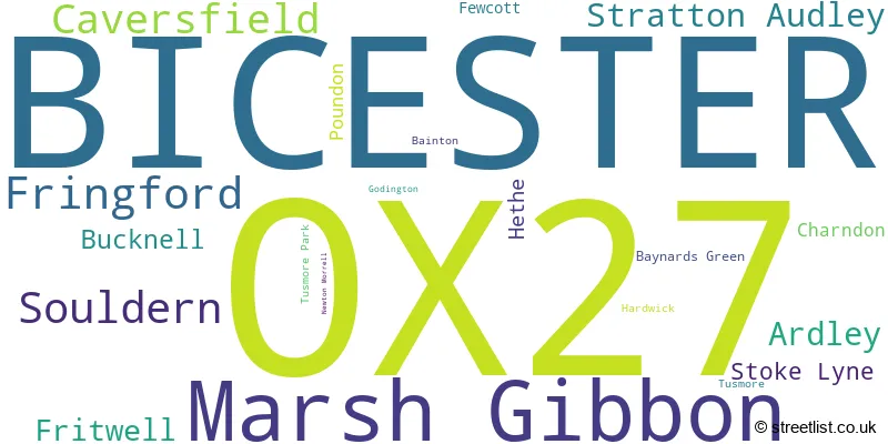
The largest settlement in the OX27 postal code is BICESTER followed by Marsh Gibbon, and Caversfield.
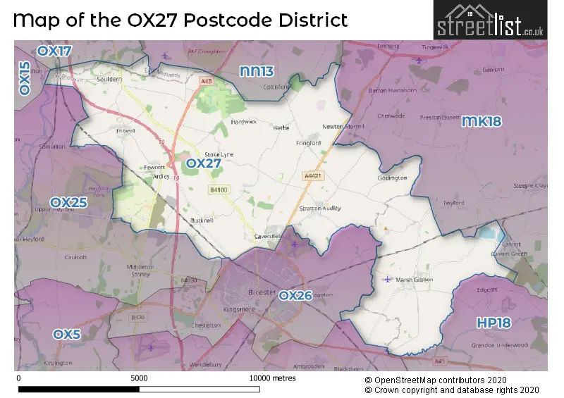
The OX27 Postcode shares a border with OX17 (Middleton Cheney, Adderbury, Kings Sutton), OX25 (Upper Heyford, Ambrosden, Weston-on-the-Green), OX26 (BICESTER, Launton, Chesterton), NN13 (BRACKLEY, Croughton, Helmdon), HP18 (AYLESBURY, Long Crendon, Waddesdon) and MK18 (BUCKINGHAM, Winslow, Steeple Claydon).
The primary settlement in the OX27 postcode district is Marsh Gibbon, located in the county of Buckinghamshire. The other significant settlements in this district include Charndon, Ardley, Baynards Green, Bucknell, Fewcott, Fritwell, Souldern, Tusmore, Bainton, Caversfield, Fringford, Hardwick, Hethe, Newton Morrell, Stoke Lyne, Godington, Poundon, and Stratton Audley, all located in the county of Oxfordshire. The most significant post town in this district is Bicester.
For the district OX27, we have data on 4 postcode sectors. Here's a breakdown: The sector OX27 0, covers Marsh Gibbon and Charndon in Buckinghamshire. The sector OX27 7, covers Souldern and Ardley and Fritwell and Bucknell in Oxfordshire. The sector OX27 8, covers Bicester and Fringford and Caversfield in Oxfordshire. The sector OX27 9, covers Stratton Audley in Oxfordshire. The sector OX27 9, covers Poundon in Buckinghamshire.

Map of the OX27 Postcode District
Explore the OX27 postcode district by using our free interactive map.
When it comes to local government, postal geography often disregards political borders. However, for a breakdown in the OX27 District: the district mostly encompasses the Cherwell District (298 postcodes), and finally, the Buckinghamshire area (66 postcodes).
Recent House Sales in OX27
| Date | Price | Address |
|---|---|---|
| 15/09/2023 | £300,000 | Old School Lane, Fritwell, Bicester, OX27 7PY |
| 11/09/2023 | £340,000 | Covert Close, Fritwell, Bicester, OX27 7AE |
| 31/08/2023 | £375,000 | Charlotte Avenue, Bicester, OX27 8AS |
| 18/08/2023 | £340,000 | Fewcott Road, Fritwell, Bicester, OX27 7QA |
| 11/08/2023 | £570,000 | Main Street, Poundon, Bicester, OX27 9BB |
| 03/08/2023 | £300,000 | Fairhaven Road, Caversfield, Bicester, OX27 8TU |
| 28/07/2023 | £285,000 | Skimmingdish Lane, Bicester, OX27 8UW |
| 28/07/2023 | £260,000 | Turnpike Road, Bicester, OX27 8UP |
| 17/07/2023 | £485,000 | Ardley Road, Fewcott, Bicester, OX27 7PA |
| 14/07/2023 | £400,000 | Sage Street, Bicester, OX27 8DE |
Weather Forecast for OX27
Press Button to Show Forecast for Bicester
| Time Period | Icon | Description | Temperature | Rain Probability | Wind |
|---|---|---|---|---|---|
| 15:00 to 18:00 | Cloudy | 12.0°C (feels like 10.0°C) | 5.00% | W 11 mph | |
| 18:00 to 21:00 | Light rain | 10.0°C (feels like 7.0°C) | 52.00% | W 11 mph | |
| 21:00 to 00:00 | Cloudy | 9.0°C (feels like 6.0°C) | 9.00% | WSW 11 mph |
Press Button to Show Forecast for Bicester
| Time Period | Icon | Description | Temperature | Rain Probability | Wind |
|---|---|---|---|---|---|
| 00:00 to 03:00 | Cloudy | 9.0°C (feels like 6.0°C) | 9.00% | W 13 mph | |
| 03:00 to 06:00 | Overcast | 9.0°C (feels like 7.0°C) | 30.00% | WNW 11 mph | |
| 06:00 to 09:00 | Overcast | 9.0°C (feels like 7.0°C) | 12.00% | WNW 11 mph | |
| 09:00 to 12:00 | Cloudy | 10.0°C (feels like 7.0°C) | 9.00% | NW 16 mph | |
| 12:00 to 15:00 | Cloudy | 12.0°C (feels like 8.0°C) | 32.00% | NW 18 mph | |
| 15:00 to 18:00 | Cloudy | 12.0°C (feels like 9.0°C) | 32.00% | NNW 16 mph | |
| 18:00 to 21:00 | Cloudy | 9.0°C (feels like 7.0°C) | 53.00% | N 11 mph | |
| 21:00 to 00:00 | Cloudy | 7.0°C (feels like 5.0°C) | 5.00% | NNE 7 mph |
Press Button to Show Forecast for Bicester
| Time Period | Icon | Description | Temperature | Rain Probability | Wind |
|---|---|---|---|---|---|
| 00:00 to 03:00 | Partly cloudy (night) | 5.0°C (feels like 3.0°C) | 3.00% | N 7 mph | |
| 03:00 to 06:00 | Partly cloudy (night) | 4.0°C (feels like 1.0°C) | 1.00% | NNW 7 mph | |
| 06:00 to 09:00 | Partly cloudy (day) | 4.0°C (feels like 1.0°C) | 1.00% | NNW 7 mph | |
| 09:00 to 12:00 | Cloudy | 7.0°C (feels like 4.0°C) | 4.00% | N 11 mph | |
| 12:00 to 15:00 | Overcast | 9.0°C (feels like 7.0°C) | 7.00% | N 9 mph | |
| 15:00 to 18:00 | Cloudy | 10.0°C (feels like 8.0°C) | 5.00% | NNE 9 mph | |
| 18:00 to 21:00 | Cloudy | 9.0°C (feels like 7.0°C) | 5.00% | NNE 7 mph | |
| 21:00 to 00:00 | Partly cloudy (night) | 6.0°C (feels like 4.0°C) | 2.00% | NE 4 mph |
Press Button to Show Forecast for Bicester
| Time Period | Icon | Description | Temperature | Rain Probability | Wind |
|---|---|---|---|---|---|
| 00:00 to 03:00 | Partly cloudy (night) | 5.0°C (feels like 4.0°C) | 1.00% | NNE 4 mph | |
| 03:00 to 06:00 | Partly cloudy (night) | 4.0°C (feels like 2.0°C) | 1.00% | N 4 mph | |
| 06:00 to 09:00 | Overcast | 5.0°C (feels like 3.0°C) | 9.00% | N 4 mph | |
| 09:00 to 12:00 | Cloudy | 8.0°C (feels like 6.0°C) | 11.00% | NNE 7 mph | |
| 12:00 to 15:00 | Overcast | 10.0°C (feels like 8.0°C) | 11.00% | NNE 9 mph | |
| 15:00 to 18:00 | Overcast | 10.0°C (feels like 8.0°C) | 11.00% | NNE 9 mph | |
| 18:00 to 21:00 | Cloudy | 9.0°C (feels like 7.0°C) | 5.00% | NE 9 mph | |
| 21:00 to 00:00 | Clear night | 7.0°C (feels like 4.0°C) | 2.00% | NE 9 mph |
Press Button to Show Forecast for Bicester
| Time Period | Icon | Description | Temperature | Rain Probability | Wind |
|---|---|---|---|---|---|
| 00:00 to 03:00 | Partly cloudy (night) | 5.0°C (feels like 2.0°C) | 3.00% | NNE 7 mph | |
| 03:00 to 06:00 | Clear night | 4.0°C (feels like 2.0°C) | 2.00% | NNE 7 mph | |
| 06:00 to 09:00 | Partly cloudy (day) | 5.0°C (feels like 2.0°C) | 2.00% | NNE 7 mph | |
| 09:00 to 12:00 | Cloudy | 8.0°C (feels like 6.0°C) | 5.00% | NNE 9 mph | |
| 12:00 to 15:00 | Cloudy | 10.0°C (feels like 8.0°C) | 6.00% | NE 11 mph | |
| 15:00 to 18:00 | Overcast | 10.0°C (feels like 8.0°C) | 10.00% | NNE 11 mph | |
| 18:00 to 21:00 | Partly cloudy (day) | 9.0°C (feels like 7.0°C) | 3.00% | NNE 9 mph | |
| 21:00 to 00:00 | Cloudy | 6.0°C (feels like 4.0°C) | 6.00% | NE 9 mph |
Where is the OX27 Postcode District?
The postcode district OX27 is located in Bicester, a town in Oxfordshire. Bicester is nearby several other towns, including Brackley to the north, Kidlington to the southwest, Buckingham to the northeast, Banbury to the northwest, Oxford to the south, and Aylesbury to the southeast. Additionally, the distance between OX27 and London is approximately 52.8 miles.
The district is within the post town of BICESTER.
The sector has postcodes within the nation of England.
The OX27 Postcode District is in the Oxfordshire region of Berkshire, Buckinghamshire and Oxfordshire within the South East (England).
| Postcode Sector | Delivery Office |
|---|---|
| OX27 0 | Bicester Delivery Office |
| OX27 7 | Bicester Delivery Office |
| OX27 8 | Bicester Delivery Office |
| OX27 9 | Bicester Delivery Office |
| O | X | 2 | 7 | - | X | X | X |
| O | X | 2 | 7 | Space | Numeric | Letter | Letter |
Current Monthly Rental Prices
| # Bedrooms | Min Price | Max Price | Avg Price |
|---|---|---|---|
| 1 | £1,200 | £1,200 | £1,200 |
| 2 | £1,150 | £1,500 | £1,325 |
| 3 | £2,150 | £2,150 | £2,150 |
| 4 | £1,795 | £4,000 | £2,898 |
| 5 | £1,800 | £1,800 | £1,800 |
Current House Prices
| # Bedrooms | Min Price | Max Price | Avg Price |
|---|---|---|---|
| £599,995 | £599,995 | £599,995 | |
| 1 | £210,000 | £250,000 | £228,000 |
| 2 | £180,000 | £425,000 | £321,409 |
| 3 | £325,000 | £875,000 | £484,998 |
| 4 | £450,000 | £2,200,000 | £763,750 |
| 5 | £525,000 | £1,900,000 | £1,050,625 |
| 6 | £975,000 | £975,000 | £975,000 |
| 8 | £2,000,000 | £2,000,000 | £2,000,000 |
Estate Agents who Operate in the OX27 District
| Logo | Name | Brand Name | Address | Contact Number | Total Properties |
|---|---|---|---|---|---|
 | Bicester | Thomas Merrifield | 39 Market Square, Bicester, OX26 6AG | 01869 221693 | 23 |
 | Bicester | Chancellors | 46 / 47 Market Square, Bicester, OX26 6AJ | 01869 221628 | 9 |
 | Bicester | Fine & Country | 10 Market Square Bicester OX26 6AG | 01869 240075 | 8 |
 | Bicester | Hunters | 37 Market Square, Bicester, OX26 6AG | 01869 221626 | 7 |
 | Bicester | Barton Fleming | 62 North Street, Bicester, OX26 6NF | 01869 221539 | 7 |
| Type of Property | 2018 Average | 2018 Sales | 2017 Average | 2017 Sales | 2016 Average | 2016 Sales | 2015 Average | 2015 Sales |
|---|---|---|---|---|---|---|---|---|
| Detached | £543,479 | 47 | £515,394 | 35 | £494,670 | 50 | £569,962 | 40 |
| Semi-Detached | £373,063 | 20 | £347,223 | 26 | £337,141 | 32 | £302,913 | 41 |
| Terraced | £321,834 | 58 | £330,646 | 48 | £336,093 | 94 | £287,965 | 44 |
| Flats | £201,483 | 15 | £258,300 | 10 | £228,125 | 12 | £243,516 | 32 |
Hotels within the Postcode Area
We found 9 hotels and guest houses within the OX27 postcode area
The Officers' Mess - The Garden Quarter
15 The Officers' Mess The Garden Quarter, Bicester, bicester-oxfordshire, OX27 8AH.
View detailsQuarters Living - 1 Building 32
1 Building 32, The Parade, Bicester, bicester-oxfordshire, OX27 8AF.
View detailsQuarters Living - 10 Building 23
10 Building 23, Trenchard Lane, Bicester, bicester-oxfordshire, OX27 8AE.
View detailsThe Garden Quarter
4 The Sergeant's Quarters, Bicester, bicester-oxfordshire, OX27 8AE.
View detailsThe Stone Barn at Stratton House
Stoke Lyne Rd, Stratton Audley, stratton-audley, OX27 9AT.
View detailsThe Garden Quarter
13, Building 32, The Parade, Caversfield, Bicester, Bicester, bicester-oxfordshire, OX27 8AD.
View detailsQuarters - Parade Apartments
The Parade,2 - Building 20, Bicester, bicester-oxfordshire, OX27 8AE.
View details