The OX29 8 postcode sector is within the county of Oxfordshire.
Did you know? According to the 2021 Census, the OX29 8 postcode sector is home to a bustling 7,481 residents!
Given that each sector allows for 400 unique postcode combinations. Letters C, I, K, M, O and V are not allowed in the last two letters of a postcode. With 218 postcodes already in use, this leaves 182 units available.
The largest settlement in the OX29 8 postal code is Long Hanborough followed by Stonesfield, and Freeland.
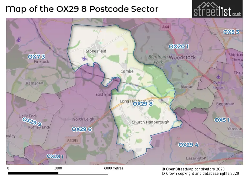
The OX29 8 Postcode shares a border with OX7 3 (Charlbury, Chadlington, Finstock), OX7 4 (Enstone, Swerford, Great Tew), OX20 1 (WOODSTOCK, Bladon, Wootton), OX29 4 (Eynsham, Cassington, Worton) and OX29 6 (North Leigh, South Leigh, New Yatt).
The sector is within the post town of WITNEY.
OX29 8 is a postcode sector within the OX29 postcode district which is within the OX Oxford postcode area.
The Royal Mail delivery office for the OX29 8 postal sector is the Witney Delivery Office.
The area of the OX29 8 postcode sector is 10.11 square miles which is 26.18 square kilometres or 6,468.84 square acres.
Waterways within the OX29 8 postcode sector include the River Evenlode, River Glyme.

Map of the OX29 8 Postcode Sector
Explore the OX29 8 postcode sector by using our free interactive map.
| O | X | 2 | 9 | - | 8 | X | X |
| O | X | 2 | 9 | Space | 8 | Letter | Letter |
Official List of Streets
Long Hanborough (47 Streets)
Combe (15 Streets)
Stonesfield (46 Streets)
Freeland (19 Streets)
Church Hanborough (3 Streets)
Unofficial Streets or Alternative Spellings
Combe
MARLBOROUGH TERRACEEynsham
FREELAND ROADNorth Leigh
CUCKOO LANEFawler
EVENLODE LANEWeather Forecast for OX29 8
Press Button to Show Forecast for Blenheim Palace
| Time Period | Icon | Description | Temperature | Rain Probability | Wind |
|---|---|---|---|---|---|
| 03:00 to 06:00 | Overcast | 6.0°C (feels like 4.0°C) | 7.00% | NNW 7 mph | |
| 06:00 to 09:00 | Cloudy | 6.0°C (feels like 4.0°C) | 4.00% | NNW 7 mph | |
| 09:00 to 12:00 | Cloudy | 7.0°C (feels like 5.0°C) | 4.00% | N 9 mph | |
| 12:00 to 15:00 | Cloudy | 10.0°C (feels like 7.0°C) | 4.00% | N 11 mph | |
| 15:00 to 18:00 | Cloudy | 10.0°C (feels like 8.0°C) | 5.00% | N 9 mph | |
| 18:00 to 21:00 | Cloudy | 10.0°C (feels like 8.0°C) | 5.00% | NNE 4 mph | |
| 21:00 to 00:00 | Partly cloudy (night) | 6.0°C (feels like 5.0°C) | 1.00% | E 4 mph |
Press Button to Show Forecast for Blenheim Palace
| Time Period | Icon | Description | Temperature | Rain Probability | Wind |
|---|---|---|---|---|---|
| 00:00 to 03:00 | Cloudy | 5.0°C (feels like 3.0°C) | 4.00% | SSW 4 mph | |
| 03:00 to 06:00 | Partly cloudy (night) | 3.0°C (feels like 1.0°C) | 1.00% | WSW 4 mph | |
| 06:00 to 09:00 | Cloudy | 4.0°C (feels like 2.0°C) | 4.00% | W 4 mph | |
| 09:00 to 12:00 | Partly cloudy (day) | 8.0°C (feels like 6.0°C) | 3.00% | W 7 mph | |
| 12:00 to 15:00 | Cloudy | 10.0°C (feels like 8.0°C) | 7.00% | WNW 9 mph | |
| 15:00 to 18:00 | Cloudy | 11.0°C (feels like 9.0°C) | 9.00% | NW 9 mph | |
| 18:00 to 21:00 | Cloudy | 10.0°C (feels like 9.0°C) | 8.00% | NNW 4 mph | |
| 21:00 to 00:00 | Cloudy | 7.0°C (feels like 6.0°C) | 6.00% | NNW 4 mph |
Press Button to Show Forecast for Blenheim Palace
| Time Period | Icon | Description | Temperature | Rain Probability | Wind |
|---|---|---|---|---|---|
| 00:00 to 03:00 | Cloudy | 5.0°C (feels like 4.0°C) | 4.00% | ENE 4 mph | |
| 03:00 to 06:00 | Cloudy | 4.0°C (feels like 2.0°C) | 7.00% | ENE 4 mph | |
| 06:00 to 09:00 | Cloudy | 5.0°C (feels like 3.0°C) | 8.00% | ESE 7 mph | |
| 09:00 to 12:00 | Cloudy | 8.0°C (feels like 6.0°C) | 9.00% | SE 7 mph | |
| 12:00 to 15:00 | Overcast | 10.0°C (feels like 8.0°C) | 15.00% | SE 7 mph | |
| 15:00 to 18:00 | Light rain shower (day) | 11.0°C (feels like 9.0°C) | 39.00% | SE 9 mph | |
| 18:00 to 21:00 | Cloudy | 10.0°C (feels like 8.0°C) | 14.00% | SE 7 mph | |
| 21:00 to 00:00 | Cloudy | 8.0°C (feels like 6.0°C) | 13.00% | ESE 7 mph |
Press Button to Show Forecast for Blenheim Palace
| Time Period | Icon | Description | Temperature | Rain Probability | Wind |
|---|---|---|---|---|---|
| 00:00 to 03:00 | Cloudy | 6.0°C (feels like 4.0°C) | 13.00% | ESE 7 mph | |
| 03:00 to 06:00 | Cloudy | 6.0°C (feels like 4.0°C) | 14.00% | E 7 mph | |
| 06:00 to 09:00 | Cloudy | 7.0°C (feels like 4.0°C) | 14.00% | E 7 mph | |
| 09:00 to 12:00 | Cloudy | 10.0°C (feels like 7.0°C) | 13.00% | E 9 mph | |
| 12:00 to 15:00 | Light rain | 11.0°C (feels like 9.0°C) | 44.00% | ENE 11 mph | |
| 15:00 to 18:00 | Light rain shower (day) | 12.0°C (feels like 10.0°C) | 39.00% | E 9 mph | |
| 18:00 to 21:00 | Light rain shower (day) | 11.0°C (feels like 9.0°C) | 34.00% | ENE 9 mph | |
| 21:00 to 00:00 | Cloudy | 9.0°C (feels like 7.0°C) | 17.00% | E 9 mph |
Schools and Places of Education Within the OX29 8 Postcode Sector
Combe CofE Primary School
Voluntary controlled school
Church Walk, Witney, Oxfordshire, OX29 8NQ
Head: Mrs Rachel Joannou
Ofsted Rating: Good
Inspection: 2022-07-07 (657 days ago)
Website: Visit Combe CofE Primary School Website
Phone: 01993891644
Number of Pupils: 117
Freeland Church of England Primary School
Academy converter
Parklands, Witney, Oxfordshire, OX29 8HX
Head: Mrs Penny McCarthy
Ofsted Rating: Good
Inspection: 2022-05-10 (715 days ago)
Website: Visit Freeland Church of England Primary School Website
Phone: 01993881707
Number of Pupils: 134
Hanborough Manor CofE School
Academy converter
Riely Close, Witney, Oxfordshire, OX29 8DJ
Head: Mrs Sarah Nickelson
Ofsted Rating: Good
Inspection: 2023-05-24 (336 days ago)
Website: Visit Hanborough Manor CofE School Website
Phone: 01993881446
Number of Pupils: 203
Stonesfield Primary School
Community school
High Street, Witney, Oxfordshire, OX29 8PU
Head: Headteacher Matt Jarvis
Ofsted Rating: Good
Inspection: 2023-02-23 (426 days ago)
Website: Visit Stonesfield Primary School Website
Phone: 01993891687
Number of Pupils: 96
House Prices in the OX29 8 Postcode Sector
| Type of Property | 2018 Average | 2018 Sales | 2017 Average | 2017 Sales | 2016 Average | 2016 Sales | 2015 Average | 2015 Sales |
|---|---|---|---|---|---|---|---|---|
| Detached | £590,362 | 57 | £564,522 | 45 | £542,200 | 38 | £496,676 | 39 |
| Semi-Detached | £367,676 | 17 | £414,559 | 30 | £338,576 | 28 | £327,145 | 20 |
| Terraced | £340,389 | 27 | £344,747 | 18 | £334,353 | 17 | £274,726 | 27 |
| Flats | £210,333 | 3 | £210,100 | 5 | £196,667 | 3 | £185,390 | 5 |
Important Postcodes OX29 8 in the Postcode Sector
OX29 8DJ is the postcode for The Manor Cp School, Riely Close, HANBOROUGH MANOR C OF E SCHOOL, RIELY CLOSE, LONG HANBOROUGH, New Building, Hanborough Manor C Of E School, Riely Close, and Hanborough Manor C Of E School, Riely Close
OX29 8HX is the postcode for FREELAND CE PRIMARY SCHOOL, PARKLANDS, FREELAND
OX29 8PU is the postcode for Stonesfield Primary School, High Street
| The OX29 8 Sector is within these Local Authorities |
|
|---|---|
| The OX29 8 Sector is within these Counties |
|
| The OX29 8 Sector is within these Water Company Areas |
|
Tourist Attractions within the OX29 8 Postcode Area
We found 1 visitor attractions within the OX29 postcode area
| Oxford Bus Museum Trust |
|---|
| Museums & Art Galleries |
| Museum and / or Art Gallery |
| View Oxford Bus Museum Trust on Google Maps |