The OX5 postcode district is a postal district located in the OX Oxford postcode area with a population of 24,117 residents according to the 2021 England and Wales Census.
The area of the OX5 postcode district is 35.46 square miles which is 91.83 square kilometres or 22,691.45 acres.
Currently, the OX5 district has about 685 postcode units spread across 3 geographic postcode sectors.
Given that each sector allows for 400 unique postcode combinations, the district has a capacity of 1,200 postcodes. With 685 postcodes already in use, this leaves 515 units available.
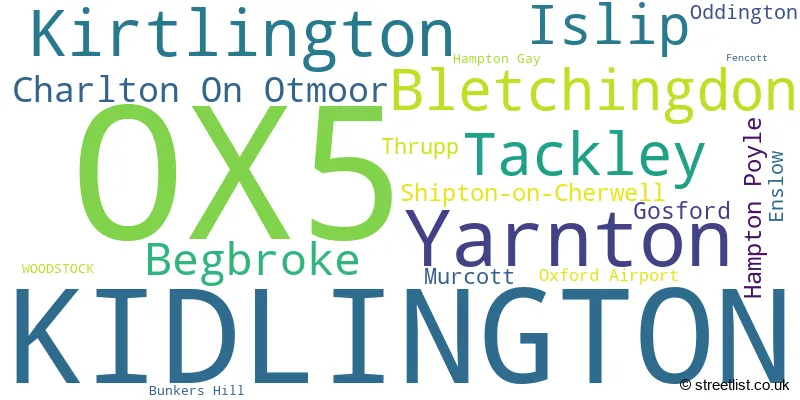
The largest settlement in the OX5 postal code is KIDLINGTON followed by Yarnton, and Kirtlington.
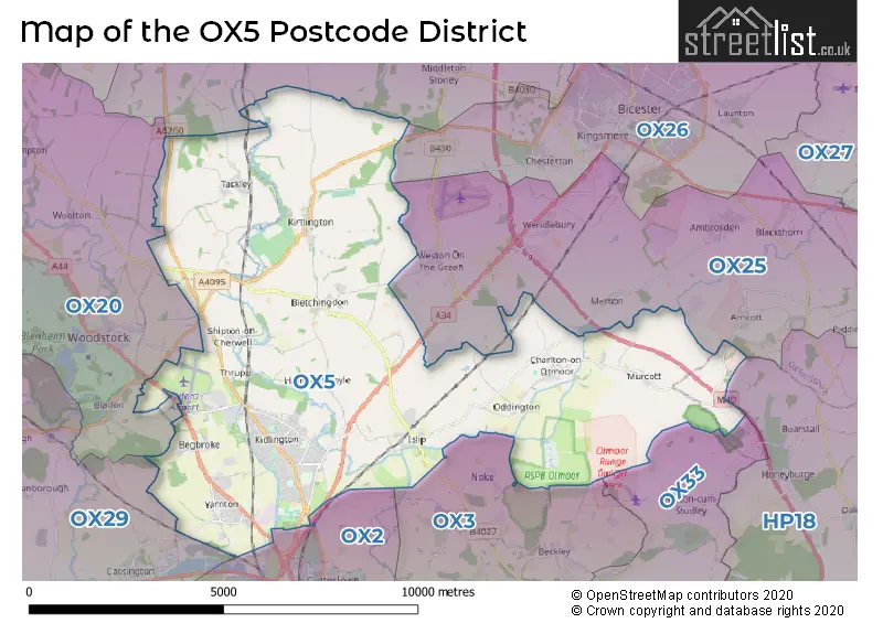
The OX5 Postcode shares a border with OX20 (WOODSTOCK, Bladon, Wootton), OX25 (Upper Heyford, Ambrosden, Weston-on-the-Green), OX2 (OXFORD, Cumnor, Wolvercote), OX3 (Headington, Marston, OXFORD) and OX33 (Wheatley, Horspath, Horton-cum-Studley).
In the OX5 postcode district, the primary settlement is Kidlington, located in Oxfordshire, England. Kidlington has the highest count of 158. Other significant settlements in this district include Begbroke, Oxford Airport, Shipton-on-Cherwell, Thrupp, and Yarnton, all also situated in Oxfordshire. The most significant post town in this district is Kidlington.
For the district OX5, we have data on 4 postcode sectors. Here's a breakdown: The sector OX5 1, covers Kidlington and Yarnton in Oxfordshire. The sector OX5 2, covers Kidlington and Islip in Oxfordshire. The sector OX5 3, covers Kirtlington and Tackley and Bletchingdon in Oxfordshire. The sector OX5 9 is non-geographic. It's often designated for PO Boxes, large organisations, or special services.

Map of the OX5 Postcode District
Explore the OX5 postcode district by using our free interactive map.
When it comes to local government, postal geography often disregards political borders. However, for a breakdown in the OX5 District: the district mostly encompasses the Cherwell District (650 postcodes), followed by the West Oxfordshire District area (38 postcodes), and finally, the Buckinghamshire area (5 postcodes).
Recent House Sales in OX5
| Date | Price | Address |
|---|---|---|
| 17/10/2023 | £172,000 | The Moors, Kidlington, OX5 2UZ |
| 09/10/2023 | £480,000 | Park Close, Kirtlington, Kidlington, OX5 3HR |
| 20/09/2023 | £525,000 | The Spears, Yarnton, Kidlington, OX5 1NS |
| 14/09/2023 | £472,500 | Station Road, Bletchingdon, Kidlington, OX5 3DE |
| 08/09/2023 | £285,000 | Oxford Road, Kidlington, OX5 1FN |
| 08/09/2023 | £630,000 | Bicester Road, Kidlington, OX5 2LF |
| 01/09/2023 | £460,000 | South Green, Kirtlington, Kidlington, OX5 3HJ |
| 31/08/2023 | £67,000 | The Moors, Kidlington, OX5 2XT |
| 31/08/2023 | £555,000 | Evans Lane, Kidlington, OX5 2HZ |
| 29/08/2023 | £575,000 | Fencott, Kidlington, OX5 2RD |
Weather Forecast for OX5
Press Button to Show Forecast for Kidlington
| Time Period | Icon | Description | Temperature | Rain Probability | Wind |
|---|---|---|---|---|---|
| 18:00 to 21:00 | Cloudy | 8.0°C (feels like 7.0°C) | 7.00% | NE 7 mph | |
| 21:00 to 00:00 | Cloudy | 6.0°C (feels like 4.0°C) | 5.00% | ENE 4 mph |
Press Button to Show Forecast for Kidlington
| Time Period | Icon | Description | Temperature | Rain Probability | Wind |
|---|---|---|---|---|---|
| 00:00 to 03:00 | Cloudy | 5.0°C (feels like 3.0°C) | 4.00% | ENE 7 mph | |
| 03:00 to 06:00 | Partly cloudy (night) | 3.0°C (feels like 1.0°C) | 1.00% | NE 4 mph | |
| 06:00 to 09:00 | Cloudy | 3.0°C (feels like 1.0°C) | 5.00% | ENE 7 mph | |
| 09:00 to 12:00 | Partly cloudy (day) | 7.0°C (feels like 5.0°C) | 2.00% | ENE 9 mph | |
| 12:00 to 15:00 | Overcast | 10.0°C (feels like 9.0°C) | 11.00% | ENE 7 mph | |
| 15:00 to 18:00 | Overcast | 10.0°C (feels like 9.0°C) | 14.00% | ENE 4 mph | |
| 18:00 to 21:00 | Cloudy | 10.0°C (feels like 9.0°C) | 13.00% | NE 4 mph | |
| 21:00 to 00:00 | Cloudy | 6.0°C (feels like 4.0°C) | 13.00% | ENE 7 mph |
Press Button to Show Forecast for Kidlington
| Time Period | Icon | Description | Temperature | Rain Probability | Wind |
|---|---|---|---|---|---|
| 00:00 to 03:00 | Cloudy | 5.0°C (feels like 3.0°C) | 12.00% | ENE 7 mph | |
| 03:00 to 06:00 | Cloudy | 4.0°C (feels like 2.0°C) | 14.00% | NE 7 mph | |
| 06:00 to 09:00 | Light rain | 4.0°C (feels like 2.0°C) | 47.00% | NE 7 mph | |
| 09:00 to 12:00 | Light rain | 8.0°C (feels like 5.0°C) | 52.00% | ENE 9 mph | |
| 12:00 to 15:00 | Overcast | 11.0°C (feels like 8.0°C) | 22.00% | ENE 11 mph | |
| 15:00 to 18:00 | Overcast | 12.0°C (feels like 9.0°C) | 20.00% | ENE 11 mph | |
| 18:00 to 21:00 | Cloudy | 10.0°C (feels like 8.0°C) | 23.00% | NE 9 mph | |
| 21:00 to 00:00 | Light rain | 8.0°C (feels like 5.0°C) | 53.00% | NE 11 mph |
Press Button to Show Forecast for Kidlington
| Time Period | Icon | Description | Temperature | Rain Probability | Wind |
|---|---|---|---|---|---|
| 00:00 to 03:00 | Heavy rain | 7.0°C (feels like 4.0°C) | 76.00% | NE 11 mph | |
| 03:00 to 06:00 | Heavy rain | 7.0°C (feels like 5.0°C) | 74.00% | NE 9 mph | |
| 06:00 to 09:00 | Heavy rain | 8.0°C (feels like 6.0°C) | 77.00% | NE 9 mph | |
| 09:00 to 12:00 | Light rain | 10.0°C (feels like 8.0°C) | 50.00% | SE 9 mph | |
| 12:00 to 15:00 | Light rain shower (day) | 11.0°C (feels like 9.0°C) | 43.00% | WSW 9 mph | |
| 15:00 to 18:00 | Light rain shower (day) | 11.0°C (feels like 9.0°C) | 40.00% | W 11 mph | |
| 18:00 to 21:00 | Light rain shower (day) | 10.0°C (feels like 8.0°C) | 34.00% | W 9 mph | |
| 21:00 to 00:00 | Partly cloudy (night) | 8.0°C (feels like 7.0°C) | 5.00% | WSW 7 mph |
Where is the OX5 Postcode District?
The postcode district of OX5 is located in the town of Kidlington. Kidlington is situated in close proximity to several nearby towns, including Woodstock (4.37 miles to the West), Bicester (5.99 miles to the North East), Oxford (6.64 miles to the South), Witney (10.71 miles to the South West), Chipping Norton (13.29 miles to the North West), Brackley (13.92 miles to the North), and Thame (14.20 miles to the South East). Furthermore, the distance from OX5 to the centre of London is approximately 53.77 miles.
The district covers the post towns of KIDLINGTON, WOODSTOCK.
The sector has postcodes within the nation of England.
The OX5 Postcode District is in the Oxfordshire region of Berkshire, Buckinghamshire and Oxfordshire within the South East (England).
| Postcode Sector | Delivery Office |
|---|---|
| OX5 1 | Kidlington Delivery Office |
| OX5 2 | Kidlington Delivery Office |
| OX5 3 | Kidlington Delivery Office |
| O | X | 5 | - | X | X | X |
| O | X | 5 | Space | Numeric | Letter | Letter |
Current Monthly Rental Prices
| # Bedrooms | Min Price | Max Price | Avg Price |
|---|---|---|---|
| £2,750 | £2,750 | £2,750 | |
| 1 | £500 | £1,350 | £1,003 |
| 2 | £1,300 | £1,450 | £1,370 |
| 3 | £1,300 | £2,750 | £1,716 |
| 4 | £3,000 | £3,000 | £3,000 |
| 5 | £2,500 | £2,850 | £2,617 |
| 7 | £5,000 | £5,000 | £5,000 |
| 8 | £121,333 | £151,667 | £141,556 |
Current House Prices
| # Bedrooms | Min Price | Max Price | Avg Price |
|---|---|---|---|
| £1,500,000 | £1,500,000 | £1,500,000 | |
| 1 | £56,250 | £354,950 | £206,787 |
| 2 | £60,000 | £650,000 | £298,796 |
| 3 | £220,000 | £1,000,000 | £461,481 |
| 4 | £365,000 | £1,750,000 | £618,674 |
| 5 | £450,000 | £2,000,000 | £943,181 |
| 6 | £800,000 | £1,850,000 | £1,123,571 |
| 7 | £2,500,000 | £18,000,000 | £10,250,000 |
| 8 | £1,000,000 | £1,000,000 | £1,000,000 |
Estate Agents who Operate in the OX5 District
| Logo | Name | Brand Name | Address | Contact Number | Total Properties |
|---|---|---|---|---|---|
 | Kidlington | Alistair Redhouse Estate Agents Ltd | 234 Botley Road Oxford OX2 0HP | 01865 364541 | 46 |
 | Kidlington | Chancellors | 7 High Street, Kidlington, OX5 2DH | 01865 638731 | 45 |
 | Kidlington | Thomas Merrifield | 1b The Hampden Building High Street, Kidlington, OX5 2DH | 01865 638870 | 44 |
 | Bicester | Chancellors | 46 / 47 Market Square, Bicester, OX26 6AJ | 01869 221628 | 24 |
 | Oxford | Cherry Picked Residential | Prama House 267 Banbury Road, Oxford, OX2 7HT | 01865 638847 | 10 |
| Type of Property | 2018 Average | 2018 Sales | 2017 Average | 2017 Sales | 2016 Average | 2016 Sales | 2015 Average | 2015 Sales |
|---|---|---|---|---|---|---|---|---|
| Detached | £595,649 | 101 | £515,826 | 105 | £603,123 | 85 | £543,280 | 106 |
| Semi-Detached | £368,596 | 142 | £357,699 | 120 | £367,002 | 159 | £347,169 | 126 |
| Terraced | £315,998 | 68 | £308,087 | 68 | £303,054 | 82 | £308,531 | 77 |
| Flats | £213,743 | 37 | £220,413 | 66 | £241,116 | 83 | £197,108 | 84 |