The PA10 postcode district is a postal district located in the PA Paisley postcode area with a population of 3,821 residents according to the 2011 Scotland Census.
The area of the PA10 postcode district is 8.18 square miles which is 21.19 square kilometres or 5,237.12 acres.
Currently, the PA10 district has about 131 postcode units spread across 1 geographic postcode sectors.
Given that each sector allows for 400 unique postcode combinations, the district has a capacity of 400 postcodes. With 131 postcodes already in use, this leaves 269 units available.
The PA10 postal code covers the settlement of Kilbarchan.
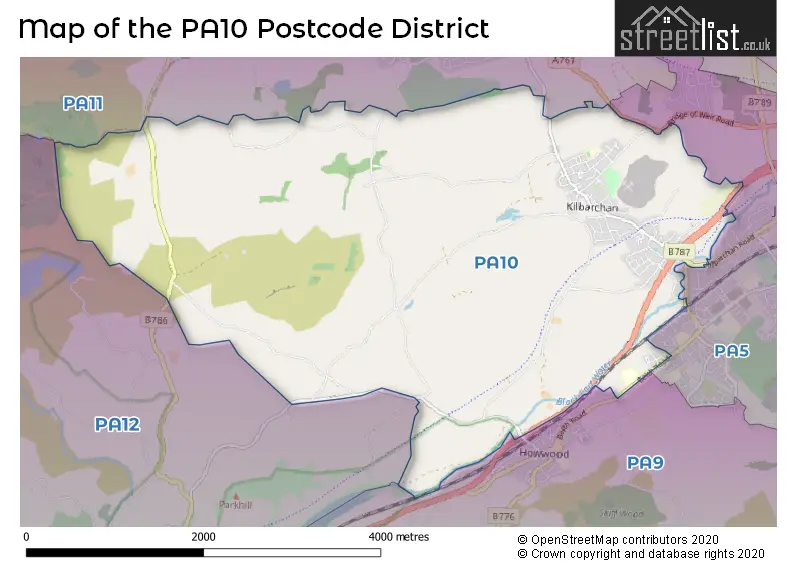
The PA10 Postcode shares a border with PA9 (Howwood), PA11 (BRIDGE OF WEIR, Quarrier's Village), PA12 (LOCHWINNOCH) and PA5 (JOHNSTONE, Elderslie, Brookfield).
The primary settlement in the PA10 postcode district is Kilbarchan, located in the county of Renfrewshire in Scotland. The post town associated with this postcode is Johnstone.
For the district PA10, we have data on 1 postcode sectors. Here's a breakdown: The sector PA10 2, covers Kilbarchan in Renfrewshire.
PA10 Postcode Sectors

Map of the PA10 Postcode District
Explore the PA10 postcode district by using our free interactive map.
When it comes to local government, postal geography often disregards political borders. However, for a breakdown in the PA10 District: the district mostly encompasses the Renfrewshire area with a total of 131 postcodes.
Weather Forecast for PA10
Press Button to Show Forecast for Howwood
| Time Period | Icon | Description | Temperature | Rain Probability | Wind |
|---|---|---|---|---|---|
| 15:00 to 18:00 | Cloudy | 10.0°C (feels like 7.0°C) | 27.00% | NW 13 mph | |
| 18:00 to 21:00 | Partly cloudy (day) | 7.0°C (feels like 4.0°C) | 30.00% | NW 11 mph | |
| 21:00 to 00:00 | Clear night | 4.0°C (feels like 2.0°C) | 6.00% | NW 7 mph |
Press Button to Show Forecast for Howwood
| Time Period | Icon | Description | Temperature | Rain Probability | Wind |
|---|---|---|---|---|---|
| 00:00 to 03:00 | Clear night | 3.0°C (feels like 0.0°C) | 1.00% | NW 7 mph | |
| 03:00 to 06:00 | Clear night | 3.0°C (feels like 0.0°C) | 0.00% | WNW 9 mph | |
| 06:00 to 09:00 | Cloudy | 4.0°C (feels like 1.0°C) | 4.00% | WNW 7 mph | |
| 09:00 to 12:00 | Cloudy | 7.0°C (feels like 4.0°C) | 4.00% | NW 9 mph | |
| 12:00 to 15:00 | Cloudy | 9.0°C (feels like 7.0°C) | 7.00% | NW 9 mph | |
| 15:00 to 18:00 | Cloudy | 10.0°C (feels like 9.0°C) | 8.00% | NW 7 mph | |
| 18:00 to 21:00 | Cloudy | 9.0°C (feels like 8.0°C) | 8.00% | NW 7 mph | |
| 21:00 to 00:00 | Cloudy | 6.0°C (feels like 4.0°C) | 6.00% | NNW 4 mph |
Press Button to Show Forecast for Howwood
| Time Period | Icon | Description | Temperature | Rain Probability | Wind |
|---|---|---|---|---|---|
| 00:00 to 03:00 | Partly cloudy (night) | 4.0°C (feels like 2.0°C) | 2.00% | WSW 2 mph | |
| 03:00 to 06:00 | Cloudy | 4.0°C (feels like 2.0°C) | 6.00% | SW 4 mph | |
| 06:00 to 09:00 | Cloudy | 5.0°C (feels like 3.0°C) | 10.00% | SW 4 mph | |
| 09:00 to 12:00 | Light rain | 8.0°C (feels like 5.0°C) | 49.00% | SW 9 mph | |
| 12:00 to 15:00 | Light rain | 9.0°C (feels like 6.0°C) | 59.00% | WSW 11 mph | |
| 15:00 to 18:00 | Heavy rain shower (day) | 10.0°C (feels like 7.0°C) | 65.00% | WSW 13 mph | |
| 18:00 to 21:00 | Light rain shower (day) | 9.0°C (feels like 6.0°C) | 40.00% | W 13 mph | |
| 21:00 to 00:00 | Cloudy | 8.0°C (feels like 5.0°C) | 8.00% | W 11 mph |
Press Button to Show Forecast for Howwood
| Time Period | Icon | Description | Temperature | Rain Probability | Wind |
|---|---|---|---|---|---|
| 00:00 to 03:00 | Overcast | 8.0°C (feels like 4.0°C) | 12.00% | WNW 11 mph | |
| 03:00 to 06:00 | Overcast | 7.0°C (feels like 4.0°C) | 10.00% | WNW 11 mph | |
| 06:00 to 09:00 | Overcast | 7.0°C (feels like 4.0°C) | 9.00% | WNW 11 mph | |
| 09:00 to 12:00 | Cloudy | 9.0°C (feels like 6.0°C) | 5.00% | NW 13 mph | |
| 12:00 to 15:00 | Cloudy | 11.0°C (feels like 8.0°C) | 5.00% | NNW 13 mph | |
| 15:00 to 18:00 | Partly cloudy (day) | 11.0°C (feels like 9.0°C) | 2.00% | NNW 11 mph | |
| 18:00 to 21:00 | Sunny day | 10.0°C (feels like 8.0°C) | 2.00% | NNW 9 mph | |
| 21:00 to 00:00 | Partly cloudy (night) | 7.0°C (feels like 4.0°C) | 1.00% | NNW 7 mph |
Press Button to Show Forecast for Howwood
| Time Period | Icon | Description | Temperature | Rain Probability | Wind |
|---|---|---|---|---|---|
| 00:00 to 03:00 | Partly cloudy (night) | 4.0°C (feels like 3.0°C) | 1.00% | NW 4 mph | |
| 03:00 to 06:00 | Partly cloudy (night) | 3.0°C (feels like 2.0°C) | 1.00% | WNW 2 mph | |
| 06:00 to 09:00 | Cloudy | 5.0°C (feels like 4.0°C) | 4.00% | W 2 mph | |
| 09:00 to 12:00 | Cloudy | 9.0°C (feels like 8.0°C) | 4.00% | W 4 mph | |
| 12:00 to 15:00 | Cloudy | 11.0°C (feels like 10.0°C) | 6.00% | W 7 mph | |
| 15:00 to 18:00 | Cloudy | 12.0°C (feels like 11.0°C) | 8.00% | W 9 mph | |
| 18:00 to 21:00 | Partly cloudy (day) | 12.0°C (feels like 10.0°C) | 2.00% | W 7 mph | |
| 21:00 to 00:00 | Cloudy | 8.0°C (feels like 7.0°C) | 4.00% | W 4 mph |
Where is the PA10 Postcode District?
The data shows that the postcode district for PA10 is in Johnstone. Johnstone is located near several towns: Bridge of Weir to the North (2.25 miles away), Kirkliston to the East (2.67 miles away), Lochwinnoch to the South West (3 miles away), Kilmacolm to the North West (4.74 miles away), Beith to the South (5.65 miles away), and Bishopton to the North East (6.29 miles away). Additionally, the distance from Johnstone to the center of London is approximately 350.22 miles.
The district is within the post town of JOHNSTONE.
The sector has postcodes within the nation of Scotland.
The PA10 Postcode District is in the Inverclyde, East Renfrewshire and Renfrewshire region of West Central Scotland within the Scotland.
Postcode Sectors within the PA10 District
| Postcode Sector | Delivery Office |
|---|---|
| PA10 2 | Johnstone Delivery Office |
| P | A | 1 | 0 | - | X | X | X |
| P | A | 1 | 0 | Space | Numeric | Letter | Letter |
Current Monthly Rental Prices
| # Bedrooms | Min Price | Max Price | Avg Price |
|---|---|---|---|
| 2 | £700 | £700 | £700 |
| 3 | £650 | £650 | £650 |
Current House Prices
| # Bedrooms | Min Price | Max Price | Avg Price |
|---|---|---|---|
| 1 | £45,000 | £45,000 | £45,000 |
| 2 | £58,000 | £137,500 | £97,750 |
| 3 | £200,000 | £220,000 | £210,000 |
| 4 | £140,000 | £300,000 | £220,000 |
Estate Agents who Operate in the PA10 District
| Logo | Name | Brand Name | Address | Contact Number | Total Properties |
|---|---|---|---|---|---|
 | Bridge Of Weir | Corum | 2 Windsor Place, Main Street, Bridge Of Weir, PA11 3AF | 01505 802786 | 3 |
 | Bridge of Weir | Lind Letting | 1 Kirkinner Place Main Street Bridge Of Weir PA11 3AA | 01505 801569 | 1 |
 | covering Paisley | Purplebricks | Suite 7 First Floor Cranmore Drive Shirley Solihull B90 4RZ | 020 3909 9868 | 1 |
 | Scotland | Yopa | Meridian House Wheatfield Way Hinckley LE10 1YG | 0161 524 0574 | 1 |
 | Glasgow | Pacitti Jones | 6 Havelock Street, Glasgow, G11 5JA | 0141 342 4886 | 1 |
Hotels within the Postcode Area
We found 1 hotels and guest houses within the PA10 postcode area