The PA67 postcode district is a postal district located in the PA Paisley postcode area with a population of 275 residents according to the 2011 Scotland Census.
The area of the PA67 postcode district is 16.65 square miles which is 43.12 square kilometres or 10,655.77 acres.
Currently, the PA67 district has about 15 postcode units spread across 1 geographic postcode sectors.
Given that each sector allows for 400 unique postcode combinations, the district has a capacity of 400 postcodes. With 15 postcodes already in use, this leaves 385 units available.
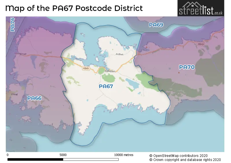
The PA67 postal code covers the settlement of Bunessan.
The postcode area has a boundary with The North Atlantic Ocean and Sea of the Hebredes.
The PA67 Postcode shares a border with PA66 (Fionnphort) and PA70 (Pennyghael).
The primary settlement in the PA67 postcode district is Bunessan, located in the Isle of Mull. It is situated in Argyll and Bute, the county of this district. The most significant postcode in this district is associated with the post town of Isle of Mull in Scotland.
For the district PA67, we have data on 1 postcode sectors. Here's a breakdown: The sector PA67 6, covers Bunessan in Argyll and Bute.
PA67 Postcode Sectors


Map of the PA67 Postcode District
Explore the PA67 postcode district by using our free interactive map.
When it comes to local government, postal geography often disregards political borders. However, for a breakdown in the PA67 District: the district mostly encompasses the Argyll and Bute area with a total of 15 postcodes.
Weather Forecast for PA67
Press Button to Show Forecast for Fionnphort
| Time Period | Icon | Description | Temperature | Rain Probability | Wind |
|---|---|---|---|---|---|
| 18:00 to 21:00 | Sunny day | 9.0°C (feels like 6.0°C) | 0.00% | N 22 mph | |
| 21:00 to 00:00 | Clear night | 8.0°C (feels like 4.0°C) | 0.00% | N 18 mph |
Press Button to Show Forecast for Fionnphort
| Time Period | Icon | Description | Temperature | Rain Probability | Wind |
|---|---|---|---|---|---|
| 00:00 to 03:00 | Clear night | 7.0°C (feels like 3.0°C) | 0.00% | N 18 mph | |
| 03:00 to 06:00 | Clear night | 6.0°C (feels like 2.0°C) | 0.00% | N 18 mph | |
| 06:00 to 09:00 | Sunny day | 6.0°C (feels like 2.0°C) | 0.00% | N 13 mph | |
| 09:00 to 12:00 | Sunny day | 7.0°C (feels like 3.0°C) | 0.00% | N 13 mph | |
| 12:00 to 15:00 | Sunny day | 8.0°C (feels like 5.0°C) | 0.00% | NNW 16 mph | |
| 15:00 to 18:00 | Sunny day | 9.0°C (feels like 5.0°C) | 0.00% | NNW 16 mph | |
| 18:00 to 21:00 | Sunny day | 8.0°C (feels like 5.0°C) | 0.00% | NNW 18 mph | |
| 21:00 to 00:00 | Clear night | 8.0°C (feels like 4.0°C) | 5.00% | NNW 16 mph |
Press Button to Show Forecast for Fionnphort
| Time Period | Icon | Description | Temperature | Rain Probability | Wind |
|---|---|---|---|---|---|
| 00:00 to 03:00 | Cloudy | 7.0°C (feels like 4.0°C) | 6.00% | NNW 16 mph | |
| 03:00 to 06:00 | Partly cloudy (night) | 7.0°C (feels like 3.0°C) | 2.00% | NNW 13 mph | |
| 06:00 to 09:00 | Cloudy | 7.0°C (feels like 3.0°C) | 4.00% | N 13 mph | |
| 09:00 to 12:00 | Cloudy | 7.0°C (feels like 4.0°C) | 13.00% | N 11 mph | |
| 12:00 to 15:00 | Cloudy | 9.0°C (feels like 6.0°C) | 5.00% | N 11 mph | |
| 15:00 to 18:00 | Cloudy | 9.0°C (feels like 7.0°C) | 5.00% | N 9 mph | |
| 18:00 to 21:00 | Partly cloudy (day) | 8.0°C (feels like 6.0°C) | 3.00% | N 11 mph | |
| 21:00 to 00:00 | Cloudy | 7.0°C (feels like 4.0°C) | 4.00% | N 9 mph |
Press Button to Show Forecast for Fionnphort
| Time Period | Icon | Description | Temperature | Rain Probability | Wind |
|---|---|---|---|---|---|
| 00:00 to 03:00 | Partly cloudy (night) | 6.0°C (feels like 3.0°C) | 2.00% | ENE 7 mph | |
| 03:00 to 06:00 | Partly cloudy (night) | 5.0°C (feels like 2.0°C) | 3.00% | E 9 mph | |
| 06:00 to 09:00 | Cloudy | 5.0°C (feels like 2.0°C) | 6.00% | E 9 mph | |
| 09:00 to 12:00 | Partly cloudy (day) | 7.0°C (feels like 4.0°C) | 4.00% | ENE 9 mph | |
| 12:00 to 15:00 | Cloudy | 8.0°C (feels like 6.0°C) | 10.00% | ENE 7 mph | |
| 15:00 to 18:00 | Cloudy | 8.0°C (feels like 6.0°C) | 9.00% | NNE 9 mph | |
| 18:00 to 21:00 | Partly cloudy (day) | 8.0°C (feels like 5.0°C) | 6.00% | N 9 mph | |
| 21:00 to 00:00 | Cloudy | 6.0°C (feels like 4.0°C) | 6.00% | NE 9 mph |
Press Button to Show Forecast for Fionnphort
| Time Period | Icon | Description | Temperature | Rain Probability | Wind |
|---|---|---|---|---|---|
| 00:00 to 03:00 | Cloudy | 5.0°C (feels like 3.0°C) | 6.00% | ENE 7 mph | |
| 03:00 to 06:00 | Partly cloudy (night) | 4.0°C (feels like 2.0°C) | 2.00% | ENE 7 mph | |
| 06:00 to 09:00 | Cloudy | 4.0°C (feels like 2.0°C) | 6.00% | ENE 9 mph | |
| 09:00 to 12:00 | Cloudy | 7.0°C (feels like 5.0°C) | 7.00% | E 9 mph | |
| 12:00 to 15:00 | Cloudy | 9.0°C (feels like 7.0°C) | 11.00% | ENE 7 mph | |
| 15:00 to 18:00 | Cloudy | 9.0°C (feels like 7.0°C) | 19.00% | NNE 9 mph | |
| 18:00 to 21:00 | Light rain shower (day) | 8.0°C (feels like 6.0°C) | 30.00% | NNE 9 mph | |
| 21:00 to 00:00 | Cloudy | 7.0°C (feels like 5.0°C) | 8.00% | NNE 7 mph |
Where is the PA67 Postcode District?
The postcode district of PA67 is located in the town of Isle of Mull. It is situated west of Isle of Iona, south of Isle of Colonsay, northwest of Isle of Coll, east of Oban, northeast of Acharacle, southeast of Lochgilphead, and north of Isle of Eigg. Furthermore, the distance from PA67 to the center of London is approximately 414.81 miles.
The district is within the post town of ISLE OF MULL.
The sector has postcodes within the nation of Scotland.
The PA67 Postcode District is covers the following regions.
- Lochaber, Skye & Lochalsh, Arran & Cumbrae and Argyll & Bute - Highlands and Islands - Scotland
- East Dunbartonshire, West Dunbartonshire and Helensburgh & Lomond - West Central Scotland - Scotland
Postcode Sectors within the PA67 District
| Postcode Sector | Delivery Office |
|---|---|
| PA67 6 | Bunessan Scale Payment Delivery Office |
| P | A | 6 | 7 | - | X | X | X |
| P | A | 6 | 7 | Space | Numeric | Letter | Letter |
Current Monthly Rental Prices
| # Bedrooms | Min Price | Max Price | Avg Price |
|---|
Current House Prices
| # Bedrooms | Min Price | Max Price | Avg Price |
|---|---|---|---|
| £55,000 | £55,000 | £55,000 | |
| 2 | £195,000 | £245,000 | £220,000 |
| 5 | £425,000 | £425,000 | £425,000 |
Estate Agents who Operate in the PA67 District
| Logo | Name | Brand Name | Address | Contact Number | Total Properties |
|---|---|---|---|---|---|
 | Oban | Bell Ingram | 5 Albany Street Oban PA34 4AR | 01631 708335 | 2 |
 | Fort William | MacPhee And Partners LLP | Airds House, An Aird, Fort William, PH33 6BL | 01397 609373 | 2 |