The PA74 postcode district is a postal district located in the PA Paisley postcode area 0
The area of the PA74 postcode district is 7.17 square miles which is 18.57 square kilometres or 4,589.19 acres.
Currently, the PA74 district has about 1 postcode units spread across 0 geographic postcode sectors.
Given that each sector allows for 400 unique postcode combinations, the district has a capacity of 0 postcodes. With 1 postcodes already in use, this leaves -1 units available.
The primary settlement in the PA74 postcode district is Torloisk, located on the Isle of Mull in Argyll and Bute, Scotland. It is the only settlement mentioned in the data provided. The post town associated with this postcode district is ISLE OF MULL, and it is located within the county of Argyll and Bute in Scotland.
For the district PA74, we have data on 1 postcode sectors. Here's a breakdown: The sector PA74 6 is non-geographic. It's often designated for PO Boxes, large organisations, or special services.
PA74 Postcode Sectors

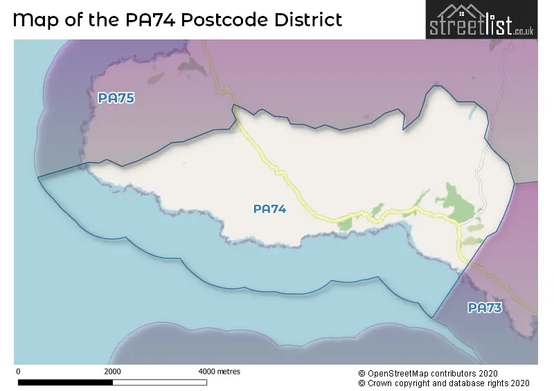
Map of the PA74 Postcode District
Explore the PA74 postcode district by using our free interactive map.
There are no postcodes assigned to any local authorities in the PA74 District.
Weather Forecast for PA74
Press Button to Show Forecast for Loch Tuath
| Time Period | Icon | Description | Temperature | Rain Probability | Wind |
|---|---|---|---|---|---|
| 15:00 to 18:00 | Sunny day | 10.0°C (feels like 6.0°C) | 0.00% | NNW 18 mph | |
| 18:00 to 21:00 | Sunny day | 10.0°C (feels like 6.0°C) | 0.00% | N 18 mph | |
| 21:00 to 00:00 | Clear night | 8.0°C (feels like 5.0°C) | 0.00% | N 13 mph |
Press Button to Show Forecast for Loch Tuath
| Time Period | Icon | Description | Temperature | Rain Probability | Wind |
|---|---|---|---|---|---|
| 00:00 to 03:00 | Clear night | 7.0°C (feels like 4.0°C) | 0.00% | N 13 mph | |
| 03:00 to 06:00 | Clear night | 6.0°C (feels like 3.0°C) | 0.00% | N 11 mph | |
| 06:00 to 09:00 | Sunny day | 6.0°C (feels like 3.0°C) | 0.00% | NNE 9 mph | |
| 09:00 to 12:00 | Sunny day | 7.0°C (feels like 4.0°C) | 0.00% | N 11 mph | |
| 12:00 to 15:00 | Sunny day | 8.0°C (feels like 5.0°C) | 0.00% | NNW 13 mph | |
| 15:00 to 18:00 | Sunny day | 9.0°C (feels like 5.0°C) | 0.00% | NNW 13 mph | |
| 18:00 to 21:00 | Sunny day | 9.0°C (feels like 5.0°C) | 0.00% | NNW 16 mph | |
| 21:00 to 00:00 | Clear night | 8.0°C (feels like 5.0°C) | 1.00% | NNW 13 mph |
Press Button to Show Forecast for Loch Tuath
| Time Period | Icon | Description | Temperature | Rain Probability | Wind |
|---|---|---|---|---|---|
| 00:00 to 03:00 | Partly cloudy (night) | 8.0°C (feels like 4.0°C) | 7.00% | NNW 13 mph | |
| 03:00 to 06:00 | Partly cloudy (night) | 7.0°C (feels like 4.0°C) | 2.00% | N 11 mph | |
| 06:00 to 09:00 | Cloudy | 7.0°C (feels like 4.0°C) | 13.00% | N 11 mph | |
| 09:00 to 12:00 | Cloudy | 7.0°C (feels like 4.0°C) | 36.00% | N 11 mph | |
| 12:00 to 15:00 | Cloudy | 8.0°C (feels like 6.0°C) | 4.00% | N 11 mph | |
| 15:00 to 18:00 | Partly cloudy (day) | 8.0°C (feels like 6.0°C) | 2.00% | NNW 11 mph | |
| 18:00 to 21:00 | Partly cloudy (day) | 8.0°C (feels like 5.0°C) | 1.00% | N 11 mph | |
| 21:00 to 00:00 | Partly cloudy (night) | 8.0°C (feels like 5.0°C) | 2.00% | NNE 9 mph |
Press Button to Show Forecast for Loch Tuath
| Time Period | Icon | Description | Temperature | Rain Probability | Wind |
|---|---|---|---|---|---|
| 00:00 to 03:00 | Cloudy | 7.0°C (feels like 5.0°C) | 6.00% | ENE 7 mph | |
| 03:00 to 06:00 | Cloudy | 6.0°C (feels like 4.0°C) | 6.00% | E 9 mph | |
| 06:00 to 09:00 | Cloudy | 6.0°C (feels like 3.0°C) | 5.00% | ENE 9 mph | |
| 09:00 to 12:00 | Partly cloudy (day) | 7.0°C (feels like 5.0°C) | 4.00% | ENE 7 mph | |
| 12:00 to 15:00 | Cloudy | 8.0°C (feels like 6.0°C) | 7.00% | NNE 7 mph | |
| 15:00 to 18:00 | Partly cloudy (day) | 8.0°C (feels like 5.0°C) | 3.00% | N 9 mph | |
| 18:00 to 21:00 | Cloudy | 8.0°C (feels like 5.0°C) | 5.00% | N 9 mph | |
| 21:00 to 00:00 | Cloudy | 7.0°C (feels like 5.0°C) | 7.00% | NE 9 mph |
Press Button to Show Forecast for Loch Tuath
| Time Period | Icon | Description | Temperature | Rain Probability | Wind |
|---|---|---|---|---|---|
| 00:00 to 03:00 | Partly cloudy (night) | 7.0°C (feels like 5.0°C) | 2.00% | ENE 7 mph | |
| 03:00 to 06:00 | Partly cloudy (night) | 6.0°C (feels like 4.0°C) | 4.00% | ENE 7 mph | |
| 06:00 to 09:00 | Cloudy | 6.0°C (feels like 4.0°C) | 6.00% | ENE 7 mph | |
| 09:00 to 12:00 | Cloudy | 7.0°C (feels like 5.0°C) | 6.00% | E 7 mph | |
| 12:00 to 15:00 | Cloudy | 8.0°C (feels like 6.0°C) | 7.00% | NE 7 mph | |
| 15:00 to 18:00 | Partly cloudy (day) | 8.0°C (feels like 6.0°C) | 6.00% | N 7 mph | |
| 18:00 to 21:00 | Sunny day | 8.0°C (feels like 6.0°C) | 6.00% | NNE 9 mph | |
| 21:00 to 00:00 | Partly cloudy (night) | 8.0°C (feels like 6.0°C) | 5.00% | NNE 9 mph |
Where is the PA74 Postcode District?
The postcode district PA74 is located in the town of Isle of Mull. Isle of Mull is nearby several towns, including Isle of Coll to the North West (approx. 13.7 miles away), Isle of Iona to the South West (approx. 15.1 miles away), Acharacle to the North East (approx. 20.2 miles away), Isle of Eigg to the North (approx. 25.7 miles away), Oban to the South East (approx. 30.4 miles away), Isle of Colonsay to the South (approx. 33.0 miles away), and Appin to the East (approx. 34.5 miles away). Furthermore, the distance from the postcode district PA74 to the centre of London is approximately 427.6 miles.
The district is within the post town of ISLE OF MULL.
The sector has postcodes within the nation of .
The PA74 Postcode District is in the region of within the .
Postcode Sectors within the PA74 District
Postcode Districts that Share a Border with PA74
| Postcode Sector | Delivery Office |
|---|---|
| PA74 6 | Aros Scale Payment Delivery Office |
| P | A | 7 | 4 | - | X | X | X |
| P | A | 7 | 4 | Space | Numeric | Letter | Letter |
Current Monthly Rental Prices
| # Bedrooms | Min Price | Max Price | Avg Price |
|---|
Current House Prices
| # Bedrooms | Min Price | Max Price | Avg Price |
|---|
Estate Agents who Operate in the PA74 District
| Logo | Name | Brand Name | Address | Contact Number | Total Properties |
|---|
| Type of Property | 2018 Average | 2018 Sales | 2017 Average | 2017 Sales | 2016 Average | 2016 Sales | 2015 Average | 2015 Sales |
|---|---|---|---|---|---|---|---|---|
| Detached | £0 | 0 | £0 | 0 | £0 | 0 | £0 | 0 |
| Semi-Detached | £0 | 0 | £0 | 0 | £0 | 0 | £0 | 0 |
| Terraced | £0 | 0 | £0 | 0 | £0 | 0 | £0 | 0 |
| Flats | £0 | 0 | £0 | 0 | £0 | 0 | £0 | 0 |