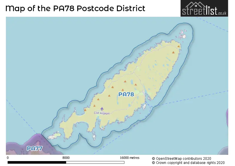
The PA78 postcode district is a postal district located in the PA Paisley postcode area with a population of 195 residents according to the 2011 Scotland Census.
The area of the PA78 postcode district is 28.29 square miles which is 73.26 square kilometres or 18,102.80 acres.
Currently, the PA78 district has about 5 postcode units spread across 1 geographic postcode sectors.
Given that each sector allows for 400 unique postcode combinations, the district has a capacity of 400 postcodes. With 5 postcodes already in use, this leaves 395 units available.
The largest settlements in the PA78 postal code are ISLE OF COLL and Arinagour.
The postcode area has a boundary with Sea of the Hebredes and The North Atlantic Ocean.
The primary settlement in the PA78 postcode district is Isle of Coll, located in the county of Argyll and Bute in Scotland. The most significant post town in this postcode district is Isle of Coll.
For the district PA78, we have data on 1 postcode sectors. Here's a breakdown: The sector PA78 6, covers Arinagour and Isle Of Coll in Argyll and Bute.
PA78 Postcode Sectors

Map of the PA78 Postcode District
Explore the PA78 postcode district by using our free interactive map.
When it comes to local government, postal geography often disregards political borders. However, for a breakdown in the PA78 District: the district mostly encompasses the Argyll and Bute area with a total of 5 postcodes.
Weather Forecast for PA78
Press Button to Show Forecast for Arinagour Isle Of Coll
| Time Period | Icon | Description | Temperature | Rain Probability | Wind |
|---|---|---|---|---|---|
| 15:00 to 18:00 | Sunny day | 10.0°C (feels like 7.0°C) | 1.00% | NNW 11 mph | |
| 18:00 to 21:00 | Sunny day | 9.0°C (feels like 6.0°C) | 0.00% | NW 9 mph | |
| 21:00 to 00:00 | Partly cloudy (night) | 8.0°C (feels like 5.0°C) | 0.00% | NW 7 mph |
Press Button to Show Forecast for Arinagour Isle Of Coll
| Time Period | Icon | Description | Temperature | Rain Probability | Wind |
|---|---|---|---|---|---|
| 00:00 to 03:00 | Cloudy | 7.0°C (feels like 6.0°C) | 4.00% | NW 4 mph | |
| 03:00 to 06:00 | Cloudy | 8.0°C (feels like 6.0°C) | 4.00% | WNW 4 mph | |
| 06:00 to 09:00 | Cloudy | 8.0°C (feels like 7.0°C) | 5.00% | W 4 mph | |
| 09:00 to 12:00 | Cloudy | 9.0°C (feels like 8.0°C) | 7.00% | WSW 7 mph | |
| 12:00 to 15:00 | Cloudy | 10.0°C (feels like 8.0°C) | 7.00% | SW 7 mph | |
| 15:00 to 18:00 | Cloudy | 10.0°C (feels like 8.0°C) | 7.00% | SW 7 mph | |
| 18:00 to 21:00 | Cloudy | 10.0°C (feels like 8.0°C) | 6.00% | WSW 7 mph | |
| 21:00 to 00:00 | Cloudy | 9.0°C (feels like 8.0°C) | 4.00% | SW 4 mph |
Press Button to Show Forecast for Arinagour Isle Of Coll
| Time Period | Icon | Description | Temperature | Rain Probability | Wind |
|---|---|---|---|---|---|
| 00:00 to 03:00 | Cloudy | 9.0°C (feels like 7.0°C) | 4.00% | SW 4 mph | |
| 03:00 to 06:00 | Cloudy | 8.0°C (feels like 7.0°C) | 6.00% | SSW 7 mph | |
| 06:00 to 09:00 | Cloudy | 8.0°C (feels like 7.0°C) | 5.00% | SSW 4 mph | |
| 09:00 to 12:00 | Cloudy | 9.0°C (feels like 8.0°C) | 5.00% | SSW 7 mph | |
| 12:00 to 15:00 | Cloudy | 10.0°C (feels like 9.0°C) | 5.00% | SW 7 mph | |
| 15:00 to 18:00 | Cloudy | 10.0°C (feels like 9.0°C) | 5.00% | W 7 mph | |
| 18:00 to 21:00 | Cloudy | 10.0°C (feels like 9.0°C) | 5.00% | WNW 7 mph | |
| 21:00 to 00:00 | Overcast | 9.0°C (feels like 8.0°C) | 8.00% | NW 7 mph |
Press Button to Show Forecast for Arinagour Isle Of Coll
| Time Period | Icon | Description | Temperature | Rain Probability | Wind |
|---|---|---|---|---|---|
| 00:00 to 03:00 | Overcast | 9.0°C (feels like 7.0°C) | 10.00% | NW 9 mph | |
| 03:00 to 06:00 | Cloudy | 9.0°C (feels like 7.0°C) | 6.00% | NW 9 mph | |
| 06:00 to 09:00 | Overcast | 9.0°C (feels like 6.0°C) | 10.00% | NW 11 mph | |
| 09:00 to 12:00 | Overcast | 10.0°C (feels like 7.0°C) | 8.00% | NNW 13 mph | |
| 12:00 to 15:00 | Cloudy | 10.0°C (feels like 7.0°C) | 6.00% | NW 13 mph | |
| 15:00 to 18:00 | Cloudy | 11.0°C (feels like 8.0°C) | 5.00% | NNW 16 mph | |
| 18:00 to 21:00 | Cloudy | 10.0°C (feels like 7.0°C) | 5.00% | NNW 18 mph | |
| 21:00 to 00:00 | Cloudy | 9.0°C (feels like 6.0°C) | 4.00% | NNW 18 mph |
Press Button to Show Forecast for Arinagour Isle Of Coll
| Time Period | Icon | Description | Temperature | Rain Probability | Wind |
|---|---|---|---|---|---|
| 00:00 to 03:00 | Cloudy | 9.0°C (feels like 5.0°C) | 4.00% | N 18 mph | |
| 03:00 to 06:00 | Partly cloudy (night) | 8.0°C (feels like 4.0°C) | 1.00% | N 18 mph | |
| 06:00 to 09:00 | Partly cloudy (day) | 8.0°C (feels like 4.0°C) | 2.00% | N 18 mph | |
| 09:00 to 12:00 | Sunny day | 9.0°C (feels like 5.0°C) | 3.00% | N 18 mph | |
| 12:00 to 15:00 | Sunny day | 10.0°C (feels like 6.0°C) | 2.00% | N 16 mph | |
| 15:00 to 18:00 | Sunny day | 10.0°C (feels like 7.0°C) | 0.00% | NNW 18 mph | |
| 18:00 to 21:00 | Sunny day | 10.0°C (feels like 6.0°C) | 0.00% | NNW 18 mph | |
| 21:00 to 00:00 | Clear night | 9.0°C (feels like 5.0°C) | 0.00% | N 18 mph |
Where is the PA78 Postcode District?
The postcode district PA78 is located in the town of Isle of Coll. Isle of Coll is situated in the vicinity of several nearby towns. To the South, there is the town of Isle of Iona, which is 21.27 miles away. To the North East, there is the town of Isle of Eigg, which is 24.78 miles away. To the East, there is the town of Acharacle, which is 27.67 miles away. Finally, to the North, there is the town of Isle of Canna, which is 29.65 miles away. Furthermore, the distance of Isle of Coll from the center of London is approximately 439.95 miles.
The district is within the post town of ISLE OF COLL.
The sector has postcodes within the nation of Scotland.
The PA78 Postcode District is covers the following regions.
- Lochaber, Skye & Lochalsh, Arran & Cumbrae and Argyll & Bute - Highlands and Islands - Scotland
- East Dunbartonshire, West Dunbartonshire and Helensburgh & Lomond - West Central Scotland - Scotland
Postcode Sectors within the PA78 District
Postcode Districts that Share a Border with PA78
| Postcode Sector | Delivery Office |
|---|---|
| PA78 6 | Coll Scale Payment Delivery Office |
| P | A | 7 | 8 | - | X | X | X |
| P | A | 7 | 8 | Space | Numeric | Letter | Letter |
Current Monthly Rental Prices
| # Bedrooms | Min Price | Max Price | Avg Price |
|---|
Current House Prices
| # Bedrooms | Min Price | Max Price | Avg Price |
|---|---|---|---|
| £1,250,000 | £1,250,000 | £1,250,000 | |
| 3 | £525,000 | £525,000 | £525,000 |
| 4 | £350,000 | £350,000 | £350,000 |
| 6 | £850,000 | £2,100,000 | £1,475,000 |
Estate Agents who Operate in the PA78 District
| Logo | Name | Brand Name | Address | Contact Number | Total Properties |
|---|---|---|---|---|---|
 | Inverness | Strutt & Parker | Perth Suite Castle House Fairways Business Park Inverness IV2 6AA | 01463 217916 | 3 |
 | covering Paisley | Purplebricks | Suite 7 First Floor Cranmore Drive Shirley Solihull B90 4RZ | 020 3909 9868 | 1 |
 | Edinburgh | Knight Frank | 80 Queen Street, Edinburgh, EH2 4NF | 0131 381 0405 | 1 |