The PE12 0 postcode sector stands on the Cambridgeshire and Lincolnshire border.
Did you know? According to the 2021 Census, the PE12 0 postcode sector is home to a bustling 6,746 residents!
Given that each sector allows for 400 unique postcode combinations. Letters C, I, K, M, O and V are not allowed in the last two letters of a postcode. With 218 postcodes already in use, this leaves 182 units available.
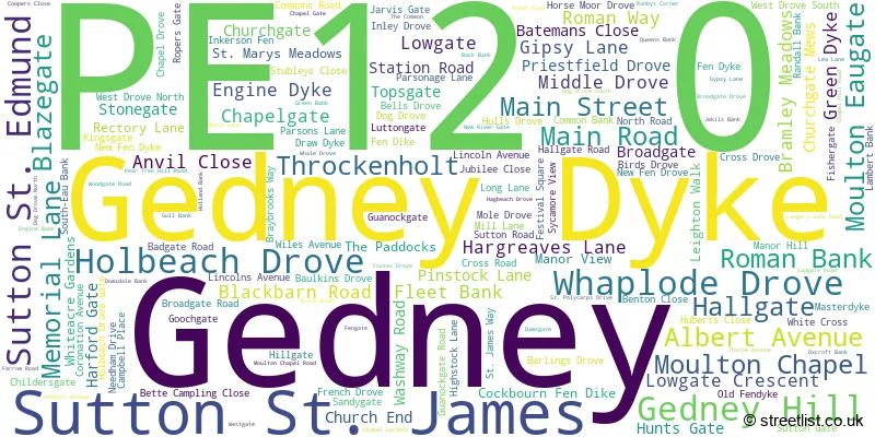
The largest settlement in the PE12 0 postal code is Sutton St. James followed by Gedney, and Gedney Hill.
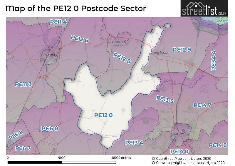
The PE12 0 Postcode shares a border with PE6 0 (Crowland, Thorney), PE13 4 (Wisbech St. Mary, Gorefield, Guyhirn), PE13 5 (Leverington, Tydd St. Giles, Newton-in-the-Isle), PE12 6 (Whaplode, Moulton, SPALDING), PE12 8 (Holbeach, Holbeach St. Matthews) and PE12 9 (Long Sutton, Sutton Bridge, Lutton).
The sector is within the post town of SPALDING.
PE12 0 is a postcode sector within the PE12 postcode district which is within the PE Peterborough postcode area.
The Royal Mail delivery office for the PE12 0 postal sector is the Spalding Delivery Office and Holbeach Delivery Office.
The area of the PE12 0 postcode sector is 46.23 square miles which is 119.74 square kilometres or 29,587.76 square acres.
Waterways within the PE12 0 postcode sector include the South Holland Main Drain.

Map of the PE12 0 Postcode Sector
Explore the PE12 0 postcode sector by using our free interactive map.
| P | E | 1 | 2 | - | 0 | X | X |
| P | E | 1 | 2 | Space | 0 | Letter | Letter |
Official List of Streets
Gedney (35 Streets)
Gedney Dyke (11 Streets)
Sutton St. James (34 Streets)
Whaplode Drove (24 Streets)
Moulton Chapel (20 Streets)
Sutton St. Edmund (7 Streets)
Holbeach Drove (8 Streets)
Throckenholt (6 Streets)
Gedney Hill (19 Streets)
Unofficial Streets or Alternative Spellings
Holbeach
LAMBERT BANK LITTLE DOG DROVE OLD MAIN ROAD RYEFIELD LANELong Sutton
GEDNEY ROAD MOORSWOOD GATETydd St. Giles
BLACK LANE BYTHORNE BANK PARK ROADGedney Hill
LINCOLN AVENUECrowland
DOWSDALE BANKWeston Hills
DELGATE BANKGedney Drove End
BLACKBARN ROADLutton
DEAR LOVE GATEWeather Forecast for PE12 0
Press Button to Show Forecast for Holbeach Drove
| Time Period | Icon | Description | Temperature | Rain Probability | Wind |
|---|---|---|---|---|---|
| 00:00 to 03:00 | Clear night | 1.0°C (feels like -1.0°C) | 0.00% | NNW 4 mph | |
| 03:00 to 06:00 | Clear night | 1.0°C (feels like -2.0°C) | 1.00% | NNW 4 mph | |
| 06:00 to 09:00 | Sunny day | 2.0°C (feels like -1.0°C) | 1.00% | NNW 7 mph | |
| 09:00 to 12:00 | Overcast | 8.0°C (feels like 6.0°C) | 8.00% | NNE 7 mph | |
| 12:00 to 15:00 | Cloudy | 9.0°C (feels like 7.0°C) | 8.00% | ENE 7 mph | |
| 15:00 to 18:00 | Cloudy | 9.0°C (feels like 7.0°C) | 8.00% | ENE 7 mph | |
| 18:00 to 21:00 | Partly cloudy (day) | 8.0°C (feels like 6.0°C) | 6.00% | ENE 9 mph | |
| 21:00 to 00:00 | Cloudy | 6.0°C (feels like 4.0°C) | 7.00% | ENE 4 mph |
Press Button to Show Forecast for Holbeach Drove
| Time Period | Icon | Description | Temperature | Rain Probability | Wind |
|---|---|---|---|---|---|
| 00:00 to 03:00 | Cloudy | 4.0°C (feels like 3.0°C) | 9.00% | E 4 mph | |
| 03:00 to 06:00 | Partly cloudy (night) | 3.0°C (feels like 1.0°C) | 6.00% | ENE 7 mph | |
| 06:00 to 09:00 | Cloudy | 5.0°C (feels like 3.0°C) | 10.00% | ENE 7 mph | |
| 09:00 to 12:00 | Overcast | 9.0°C (feels like 7.0°C) | 17.00% | ENE 9 mph | |
| 12:00 to 15:00 | Overcast | 11.0°C (feels like 8.0°C) | 20.00% | ENE 11 mph | |
| 15:00 to 18:00 | Cloudy | 11.0°C (feels like 8.0°C) | 14.00% | ENE 13 mph | |
| 18:00 to 21:00 | Cloudy | 9.0°C (feels like 7.0°C) | 14.00% | ENE 11 mph | |
| 21:00 to 00:00 | Light rain | 8.0°C (feels like 5.0°C) | 51.00% | NE 11 mph |
Press Button to Show Forecast for Holbeach Drove
| Time Period | Icon | Description | Temperature | Rain Probability | Wind |
|---|---|---|---|---|---|
| 00:00 to 03:00 | Light rain | 8.0°C (feels like 5.0°C) | 48.00% | NE 13 mph | |
| 03:00 to 06:00 | Heavy rain | 8.0°C (feels like 6.0°C) | 75.00% | NE 11 mph | |
| 06:00 to 09:00 | Heavy rain | 9.0°C (feels like 7.0°C) | 78.00% | E 9 mph | |
| 09:00 to 12:00 | Light rain | 12.0°C (feels like 9.0°C) | 53.00% | ESE 11 mph | |
| 12:00 to 15:00 | Light rain shower (day) | 12.0°C (feels like 10.0°C) | 45.00% | SSE 11 mph | |
| 15:00 to 18:00 | Heavy rain | 12.0°C (feels like 10.0°C) | 74.00% | SSW 11 mph | |
| 18:00 to 21:00 | Light rain shower (day) | 11.0°C (feels like 8.0°C) | 37.00% | SSW 11 mph | |
| 21:00 to 00:00 | Partly cloudy (night) | 8.0°C (feels like 6.0°C) | 6.00% | SW 9 mph |
Schools and Places of Education Within the PE12 0 Postcode Sector
Gedney Church End Primary Academy
Academy converter
Church End, Spalding, Lincolnshire, PE12 0BU
Head: Mrs Valerie Rose
Ofsted Rating: Special Measures
Inspection: 2023-03-17 (406 days ago)
Website: Visit Gedney Church End Primary Academy Website
Phone: 01406362383
Number of Pupils: 69
Moulton Chapel Primary School
Community school
Eaugate Road, Spalding, Lincolnshire, PE12 0XJ
Head: Mrs Lisa Sexton
Ofsted Rating: Good
Inspection: 2021-07-13 (1018 days ago)
Website: Visit Moulton Chapel Primary School Website
Phone: 01406380440
Number of Pupils: 72
Shepeau Stow Primary School
Community school
Dowsdale Bank, Spalding, Lincolnshire, PE12 0TX
Head: Mrs Alison Buddle
Ofsted Rating: Requires improvement
Inspection: 2022-11-16 (527 days ago)
Website: Visit Shepeau Stow Primary School Website
Phone: 01406330395
Number of Pupils: 70
Sutton St James Community Primary School
Community school
Bells Drove, Spalding, Lincolnshire, PE12 0JG
Head: Miss Claire Willows
Ofsted Rating: Good
Inspection: 2021-11-30 (878 days ago)
Website: Visit Sutton St James Community Primary School Website
Phone: 01945440209
Number of Pupils: 116
The Gedney Hill Church of England VC Primary School
Voluntary controlled school
North Road, Spalding, Lincolnshire, PE12 0NL
Head: Mrs Alison Buddle
Ofsted Rating: Requires improvement
Inspection: 2023-02-22 (429 days ago)
Website: Visit The Gedney Hill Church of England VC Primary School Website
Phone: 01406330258
Number of Pupils: 70
House Prices in the PE12 0 Postcode Sector
| Type of Property | 2018 Average | 2018 Sales | 2017 Average | 2017 Sales | 2016 Average | 2016 Sales | 2015 Average | 2015 Sales |
|---|---|---|---|---|---|---|---|---|
| Detached | £252,349 | 73 | £248,817 | 64 | £230,125 | 102 | £214,517 | 89 |
| Semi-Detached | £164,125 | 24 | £157,763 | 19 | £143,098 | 22 | £129,180 | 29 |
| Terraced | £124,000 | 4 | £130,200 | 5 | £130,667 | 3 | £115,998 | 2 |
| Flats | £0 | 0 | £0 | 0 | £0 | 0 | £120,864 | 1 |
Important Postcodes PE12 0 in the Postcode Sector
PE12 0BU is the postcode for Gedney Church End Primary School, Church End
PE12 0JG is the postcode for County School, Bells Drove
PE12 0NL is the postcode for Gedney Hill C of E Primary School, North Road
PE12 0TX is the postcode for Shepeau Stow Primary School, Dowsdale Bank
PE12 0XJ is the postcode for Moulton Chapel Primary School, Eaugate Road
| The PE12 0 Sector is within these Local Authorities |
|
|---|---|
| The PE12 0 Sector is within these Counties |
|
| The PE12 0 Sector is within these Water Company Areas |
|