The PE28 2 postcode sector is within the county of Cambridgeshire.
Did you know? According to the 2021 Census, the PE28 2 postcode sector is home to a bustling 10,088 residents!
Given that each sector allows for 400 unique postcode combinations. Letters C, I, K, M, O and V are not allowed in the last two letters of a postcode. With 292 postcodes already in use, this leaves 108 units available.
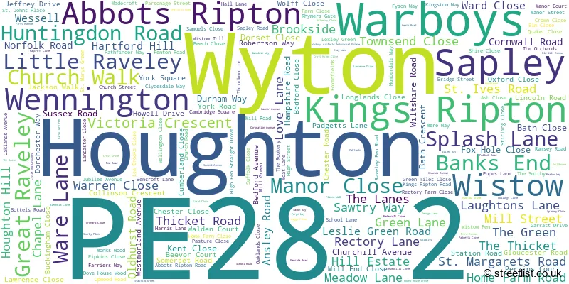
The largest settlement in the PE28 2 postal code is Warboys followed by Wyton, and Houghton.
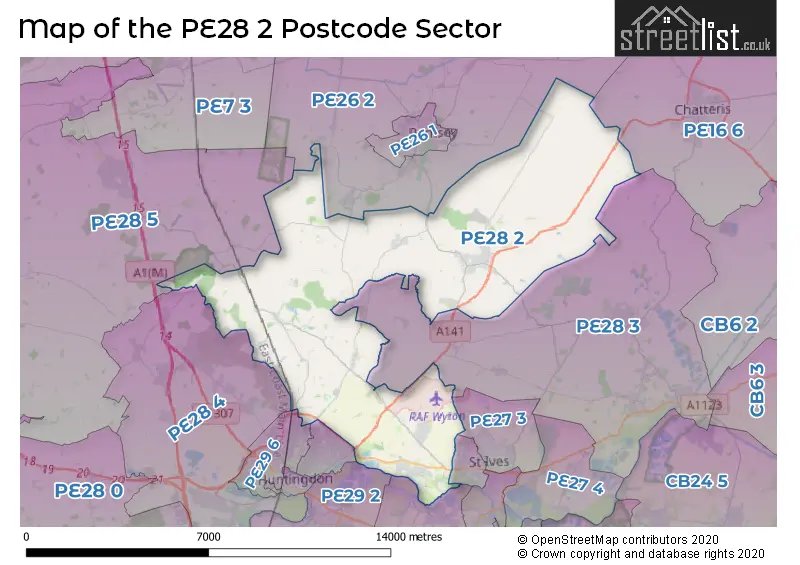
The PE28 2 Postcode shares a border with PE16 6 (CHATTERIS), PE29 7 (HUNTINGDON), PE26 2 (Ramsey), PE27 3 (ST. IVES), PE27 6 (ST. IVES), PE28 3 (Somersham, Bluntisham, Earith), PE28 4 (Brampton, Alconbury, Alconbury Weald), PE28 5 (Sawtry, Glatton, Woodwalton), PE28 9 (Fenstanton, Hemingford Grey, Hilton), PE29 1 (HUNTINGDON, Hartford), PE29 6 (HUNTINGDON, Ermine Business Park, Stukeley Meadows Industrial Estate) and PE29 2 (Godmanchester).
The sector is within the post town of HUNTINGDON.
PE28 2 is a postcode sector within the PE28 postcode district which is within the PE Peterborough postcode area.
The Royal Mail delivery office for the PE28 2 postal sector is the Warboys Scale Payment Delivery Office and Huntingdon Delivery Office.
The area of the PE28 2 postcode sector is 39.28 square miles which is 101.74 square kilometres or 25,139.47 square acres.
Waterways within the PE28 2 postcode sector include the River Great Ouse, Great Raveley Drain.

Map of the PE28 2 Postcode Sector
Explore the PE28 2 postcode sector by using our free interactive map.
| P | E | 2 | 8 | - | 2 | X | X |
| P | E | 2 | 8 | Space | 2 | Letter | Letter |
Official List of Streets
Sapley (12 Streets)
Houghton (21 Streets)
Warboys (81 Streets)
Wistow (15 Streets)
Wyton (45 Streets)
Abbots Ripton (12 Streets)
Kings Ripton (6 Streets)
Great Raveley (2 Streets)
Little Raveley (1 Streets)
Unofficial Streets or Alternative Spellings
Tick Fen
ROUND HOUSE DROVEST. IVES
HOUGHTON ROADPidley
FEN ROADRamsey
CHAPEL ROAD HUNTINGDON ROADHartford
CONEYGEAR ROAD OLD HOUGHTON ROAD SAPLEY ROADWeather Forecast for PE28 2
Press Button to Show Forecast for Monks Wood
| Time Period | Icon | Description | Temperature | Rain Probability | Wind |
|---|---|---|---|---|---|
| 18:00 to 21:00 | Cloudy | 7.0°C (feels like 6.0°C) | 7.00% | NE 2 mph | |
| 21:00 to 00:00 | Clear night | 4.0°C (feels like 2.0°C) | 1.00% | NE 2 mph |
Press Button to Show Forecast for Monks Wood
| Time Period | Icon | Description | Temperature | Rain Probability | Wind |
|---|---|---|---|---|---|
| 00:00 to 03:00 | Clear night | 1.0°C (feels like -1.0°C) | 1.00% | N 2 mph | |
| 03:00 to 06:00 | Clear night | 1.0°C (feels like -2.0°C) | 0.00% | N 2 mph | |
| 06:00 to 09:00 | Sunny day | 2.0°C (feels like 0.0°C) | 1.00% | N 2 mph | |
| 09:00 to 12:00 | Sunny day | 8.0°C (feels like 6.0°C) | 1.00% | NE 4 mph | |
| 12:00 to 15:00 | Cloudy | 10.0°C (feels like 9.0°C) | 5.00% | NE 4 mph | |
| 15:00 to 18:00 | Overcast | 10.0°C (feels like 9.0°C) | 11.00% | ENE 4 mph | |
| 18:00 to 21:00 | Cloudy | 8.0°C (feels like 6.0°C) | 11.00% | NE 4 mph | |
| 21:00 to 00:00 | Cloudy | 6.0°C (feels like 4.0°C) | 12.00% | ENE 2 mph |
Press Button to Show Forecast for Monks Wood
| Time Period | Icon | Description | Temperature | Rain Probability | Wind |
|---|---|---|---|---|---|
| 00:00 to 03:00 | Cloudy | 5.0°C (feels like 3.0°C) | 11.00% | ENE 2 mph | |
| 03:00 to 06:00 | Cloudy | 4.0°C (feels like 2.0°C) | 9.00% | NE 2 mph | |
| 06:00 to 09:00 | Cloudy | 4.0°C (feels like 2.0°C) | 13.00% | NE 4 mph | |
| 09:00 to 12:00 | Cloudy | 9.0°C (feels like 7.0°C) | 17.00% | ENE 7 mph | |
| 12:00 to 15:00 | Overcast | 11.0°C (feels like 9.0°C) | 21.00% | ENE 7 mph | |
| 15:00 to 18:00 | Overcast | 12.0°C (feels like 9.0°C) | 20.00% | ENE 9 mph | |
| 18:00 to 21:00 | Cloudy | 10.0°C (feels like 7.0°C) | 18.00% | NE 7 mph | |
| 21:00 to 00:00 | Light rain | 8.0°C (feels like 5.0°C) | 53.00% | NE 7 mph |
Press Button to Show Forecast for Monks Wood
| Time Period | Icon | Description | Temperature | Rain Probability | Wind |
|---|---|---|---|---|---|
| 00:00 to 03:00 | Light rain | 8.0°C (feels like 5.0°C) | 49.00% | NE 7 mph | |
| 03:00 to 06:00 | Heavy rain | 8.0°C (feels like 5.0°C) | 77.00% | NE 7 mph | |
| 06:00 to 09:00 | Light rain | 9.0°C (feels like 7.0°C) | 56.00% | E 4 mph | |
| 09:00 to 12:00 | Light rain | 11.0°C (feels like 9.0°C) | 47.00% | SE 7 mph | |
| 12:00 to 15:00 | Heavy rain shower (day) | 12.0°C (feels like 10.0°C) | 62.00% | SE 7 mph | |
| 15:00 to 18:00 | Heavy rain shower (day) | 12.0°C (feels like 10.0°C) | 60.00% | SW 9 mph | |
| 18:00 to 21:00 | Light rain shower (day) | 11.0°C (feels like 9.0°C) | 35.00% | ENE 7 mph | |
| 21:00 to 00:00 | Partly cloudy (night) | 9.0°C (feels like 6.0°C) | 6.00% | SW 4 mph |
Schools and Places of Education Within the PE28 2 Postcode Sector
Abbots Ripton CofE Primary School
Voluntary aided school
Wennington Road, Huntingdon, Cambridgeshire, PE28 2LT
Head: Mrs Claire Matthews
Ofsted Rating: Good
Inspection: 2019-02-13 (1898 days ago)
Website: Visit Abbots Ripton CofE Primary School Website
Phone: 01487773318
Number of Pupils: 95
Houghton Primary School
Community school
Chapel Lane, Huntingdon, Cambridgeshire, PE28 2AY
Head: Mr Andrew Spencer
Ofsted Rating: Good
Inspection: 2023-03-23 (399 days ago)
Website: Visit Houghton Primary School Website
Phone: 01480463398
Number of Pupils: 177
Warboys Primary Academy
Academy converter
Humberdale Way, Huntingdon, Cambridgeshire, PE28 2RX
Head: Mr Stuart Mallott
Ofsted Rating: Good
Inspection: 2023-03-30 (392 days ago)
Website: Visit Warboys Primary Academy Website
Phone: 01487822317
Number of Pupils: 332
Wyton on the Hill Community Primary School
Community school
Cambridge Square, Huntingdon, Cambridgeshire, PE28 2JB
Head: Ms Jo Phillips
Ofsted Rating: Good
Inspection: 2023-05-11 (350 days ago)
Website: Visit Wyton on the Hill Community Primary School Website
Phone: 01480572995
Number of Pupils: 175
House Prices in the PE28 2 Postcode Sector
| Type of Property | 2018 Average | 2018 Sales | 2017 Average | 2017 Sales | 2016 Average | 2016 Sales | 2015 Average | 2015 Sales |
|---|---|---|---|---|---|---|---|---|
| Detached | £371,641 | 63 | £407,962 | 81 | £380,573 | 72 | £340,694 | 72 |
| Semi-Detached | £228,235 | 34 | £231,278 | 40 | £216,264 | 45 | £198,288 | 46 |
| Terraced | £209,143 | 48 | £202,635 | 37 | £197,688 | 45 | £158,500 | 43 |
| Flats | £147,875 | 8 | £146,917 | 6 | £133,179 | 21 | £179,892 | 19 |
Important Postcodes PE28 2 in the Postcode Sector
PE28 2AY is the postcode for Houghton Primary School, Chapel Lane
PE28 2EA is the postcode for BUILDING 733, RAF Wyton, Sawtry Way, and RAF Wyton & RAF Brampton, Wyton
PE28 2JB is the postcode for Wyton on the Hill Primary School, Cambridge Square, Wyton, Wyton on the Hill Primary School, Cambridge Square, and CAMBRIDGE SQUARE, WYTON ON THE HILL
PE28 2LT is the postcode for Abbots Ripton C of E School, Abbots Ripton
PE28 2RX is the postcode for Warboys Primary Academy, Humberdale Way, Warboys, and Warboys Cp School, Humberdale Way
| The PE28 2 Sector is within these Local Authorities |
|
|---|---|
| The PE28 2 Sector is within these Counties |
|
| The PE28 2 Sector is within these Water Company Areas |
|
Tourist Attractions within the PE28 2 Postcode Area
We found 1 visitor attractions within the PE28 postcode area
| Houghton Mill |
|---|
| Historic Properties |
| Other Historic Property |
| View Houghton Mill on Google Maps |