The PE5 postcode district is a postal district located in the PE Peterborough postcode area with a population of 1,540 residents according to the 2021 England and Wales Census.
The area of the PE5 postcode district is 3.98 square miles which is 10.31 square kilometres or 2,547.52 acres.
Currently, the PE5 district has about 51 postcode units spread across 1 geographic postcode sectors.
Given that each sector allows for 400 unique postcode combinations, the district has a capacity of 400 postcodes. With 51 postcodes already in use, this leaves 349 units available.
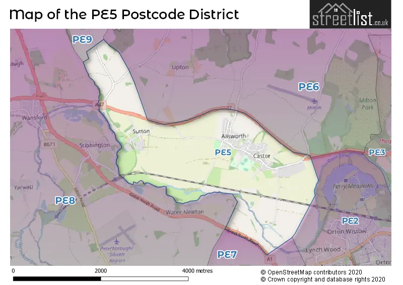
The largest settlement in the PE5 postal code is Castor followed by Ailsworth, and Sutton.
The PE5 Postcode shares a border with PE7 (Whittlesey, Yaxley, Hampton Vale), PE6 (Market Deeping, Deeping St. James, Crowland) and PE8 (Oundle, Wittering, Kings Cliffe).
In the PE5 postcode district in Cambridgeshire, the primary settlement is Ailsworth. Other significant settlements include Castor and Sutton. The post town for this district is Peterborough. Ailsworth has the highest count of 13, while Castor has a count of 30 and Sutton has a count of 8.
For the district PE5, we have data on 1 postcode sectors. Here's a breakdown: The sector PE5 7, covers Castor and Ailsworth and Sutton in Cambridgeshire.
PE5 Postcode Sectors


Map of the PE5 Postcode District
Explore the PE5 postcode district by using our free interactive map.
When it comes to local government, postal geography often disregards political borders. However, for a breakdown in the PE5 District: the district mostly encompasses the City of Peterborough (B) area with a total of 52 postcodes.
Recent House Sales in PE5
| Date | Price | Address |
|---|---|---|
| 07/08/2023 | £350,000 | Main Street, Ailsworth, Peterborough, PE5 7AF |
| 07/07/2023 | £540,000 | Peterborough Road, Castor, Peterborough, PE5 7AX |
| 07/06/2023 | £208,000 | Silvester Road, Castor, Peterborough, PE5 7BA |
| 05/06/2023 | £520,000 | Peterborough Road, Castor, Peterborough, PE5 7AX |
| 27/03/2023 | £500,000 | Normangate, Ailsworth, Peterborough, PE5 7BF |
| 27/03/2023 | £270,000 | Main Street, Ailsworth, Peterborough, PE5 7AF |
| 15/12/2022 | £335,000 | Main Street, Ailsworth, Peterborough, PE5 7AF |
| 25/10/2022 | £300,000 | Peterborough Road, Castor, Peterborough, PE5 7AX |
| 14/10/2022 | £915,000 | Water Lane, Castor, Peterborough, PE5 7BJ |
| 16/09/2022 | £295,000 | Benams Close, Castor, Peterborough, PE5 7AW |
Weather Forecast for PE5
Press Button to Show Forecast for West Town Primary Academy
| Time Period | Icon | Description | Temperature | Rain Probability | Wind |
|---|---|---|---|---|---|
| 03:00 to 06:00 | Partly cloudy (night) | 4.0°C (feels like 1.0°C) | 4.00% | NW 9 mph | |
| 06:00 to 09:00 | Partly cloudy (day) | 5.0°C (feels like 1.0°C) | 1.00% | NW 9 mph | |
| 09:00 to 12:00 | Cloudy | 7.0°C (feels like 4.0°C) | 8.00% | N 13 mph | |
| 12:00 to 15:00 | Overcast | 9.0°C (feels like 6.0°C) | 8.00% | N 13 mph | |
| 15:00 to 18:00 | Cloudy | 9.0°C (feels like 7.0°C) | 5.00% | N 11 mph | |
| 18:00 to 21:00 | Partly cloudy (day) | 9.0°C (feels like 6.0°C) | 1.00% | NNE 9 mph | |
| 21:00 to 00:00 | Cloudy | 6.0°C (feels like 4.0°C) | 4.00% | ENE 4 mph |
Press Button to Show Forecast for West Town Primary Academy
| Time Period | Icon | Description | Temperature | Rain Probability | Wind |
|---|---|---|---|---|---|
| 00:00 to 03:00 | Cloudy | 5.0°C (feels like 2.0°C) | 3.00% | WSW 7 mph | |
| 03:00 to 06:00 | Partly cloudy (night) | 4.0°C (feels like 1.0°C) | 1.00% | WSW 7 mph | |
| 06:00 to 09:00 | Cloudy | 5.0°C (feels like 2.0°C) | 5.00% | WSW 9 mph | |
| 09:00 to 12:00 | Cloudy | 9.0°C (feels like 6.0°C) | 8.00% | WNW 11 mph | |
| 12:00 to 15:00 | Cloudy | 10.0°C (feels like 8.0°C) | 11.00% | WNW 11 mph | |
| 15:00 to 18:00 | Cloudy | 10.0°C (feels like 8.0°C) | 10.00% | NNW 9 mph | |
| 18:00 to 21:00 | Cloudy | 8.0°C (feels like 6.0°C) | 8.00% | N 7 mph | |
| 21:00 to 00:00 | Partly cloudy (night) | 6.0°C (feels like 4.0°C) | 1.00% | NE 4 mph |
Press Button to Show Forecast for West Town Primary Academy
| Time Period | Icon | Description | Temperature | Rain Probability | Wind |
|---|---|---|---|---|---|
| 00:00 to 03:00 | Partly cloudy (night) | 4.0°C (feels like 2.0°C) | 1.00% | NE 4 mph | |
| 03:00 to 06:00 | Cloudy | 3.0°C (feels like 1.0°C) | 4.00% | N 4 mph | |
| 06:00 to 09:00 | Cloudy | 4.0°C (feels like 2.0°C) | 5.00% | NE 4 mph | |
| 09:00 to 12:00 | Cloudy | 8.0°C (feels like 6.0°C) | 7.00% | E 7 mph | |
| 12:00 to 15:00 | Cloudy | 10.0°C (feels like 9.0°C) | 9.00% | ESE 7 mph | |
| 15:00 to 18:00 | Cloudy | 11.0°C (feels like 9.0°C) | 10.00% | ESE 7 mph | |
| 18:00 to 21:00 | Cloudy | 10.0°C (feels like 8.0°C) | 11.00% | ESE 9 mph | |
| 21:00 to 00:00 | Cloudy | 7.0°C (feels like 5.0°C) | 9.00% | ESE 9 mph |
Press Button to Show Forecast for West Town Primary Academy
| Time Period | Icon | Description | Temperature | Rain Probability | Wind |
|---|---|---|---|---|---|
| 00:00 to 03:00 | Cloudy | 6.0°C (feels like 4.0°C) | 13.00% | E 7 mph | |
| 03:00 to 06:00 | Cloudy | 6.0°C (feels like 3.0°C) | 15.00% | E 7 mph | |
| 06:00 to 09:00 | Cloudy | 6.0°C (feels like 4.0°C) | 14.00% | E 7 mph | |
| 09:00 to 12:00 | Overcast | 10.0°C (feels like 8.0°C) | 16.00% | ESE 9 mph | |
| 12:00 to 15:00 | Cloudy | 12.0°C (feels like 10.0°C) | 26.00% | ESE 9 mph | |
| 15:00 to 18:00 | Light rain shower (day) | 12.0°C (feels like 10.0°C) | 31.00% | ESE 9 mph | |
| 18:00 to 21:00 | Cloudy | 11.0°C (feels like 9.0°C) | 15.00% | E 9 mph | |
| 21:00 to 00:00 | Cloudy | 9.0°C (feels like 8.0°C) | 15.00% | E 9 mph |
Where is the PE5 Postcode District?
The data's postcode district, PE5, is located in the town of Peterborough. Peterborough is surrounded by several nearby towns, including Stamford to the North West, Bourne to the North, Corby to the South West, Spalding to the North East, Oakham to the West, March to the East, and Huntingdon to the South East. Furthermore, Peterborough is approximately 74.27 miles away from the center of London.
The district is within the post town of PETERBOROUGH.
The sector has postcodes within the nation of England.
The PE5 Postcode District is in the Peterborough region of East Anglia within the East of England.
Postcode Sectors within the PE5 District
| Postcode Sector | Delivery Office |
|---|---|
| PE5 7 | Peterborough Postal Delivery Office |
| PE5 7 | Ailsworth Scale Payment Delivery Office |
| P | E | 5 | - | X | X | X |
| P | E | 5 | Space | Numeric | Letter | Letter |
Current Monthly Rental Prices
| # Bedrooms | Min Price | Max Price | Avg Price |
|---|---|---|---|
| 1 | £450 | £550 | £500 |
| 3 | £1,350 | £1,475 | £1,413 |
Current House Prices
| # Bedrooms | Min Price | Max Price | Avg Price |
|---|---|---|---|
| 3 | £350,000 | £750,000 | £528,000 |
| 4 | £395,000 | £955,000 | £691,500 |
| 5 | £675,000 | £675,000 | £675,000 |
Estate Agents who Operate in the PE5 District
| Logo | Name | Brand Name | Address | Contact Number | Total Properties |
|---|---|---|---|---|---|
 | Bourne | Quentin Marks Estate Agents | 2 West Street, Bourne, PE10 9NE | 01778 301117 | 10 |
 | Peterborough | Capitol Lettors | Peterborough, PE8 | 01733 553366 | 2 |
 | Peterborough | Sharman Quinney | 181 Newark Avenue Peterborough PE1 4NL | 01733 964661 | 1 |
 | Stamford | Knight Partnership Lettings | 3 Red Lion Street, Stamford, PE9 1PA | 01780 431646 | 1 |
 | Rutland | Hurfords | 21 High Street East, Uppingham, LE15 9PY | 01572 494655 | 1 |
| Type of Property | 2018 Average | 2018 Sales | 2017 Average | 2017 Sales | 2016 Average | 2016 Sales | 2015 Average | 2015 Sales |
|---|---|---|---|---|---|---|---|---|
| Detached | £532,867 | 15 | £523,192 | 13 | £484,071 | 21 | £508,079 | 19 |
| Semi-Detached | £245,000 | 2 | £237,500 | 2 | £325,100 | 5 | £0 | 0 |
| Terraced | £120,000 | 1 | £221,167 | 3 | £199,983 | 3 | £225,929 | 7 |
| Flats | £0 | 0 | £0 | 0 | £0 | 0 | £0 | 0 |