The PE9 postcode district is a postal district located in the PE Peterborough postcode area with a population of 33,295 residents according to the 2021 England and Wales Census.
The area of the PE9 postcode district is 76.89 square miles which is 199.15 square kilometres or 49,210.63 acres.
Currently, the PE9 district has about 1014 postcode units spread across 4 geographic postcode sectors.
Given that each sector allows for 400 unique postcode combinations, the district has a capacity of 1,600 postcodes. With 1014 postcodes already in use, this leaves 586 units available.
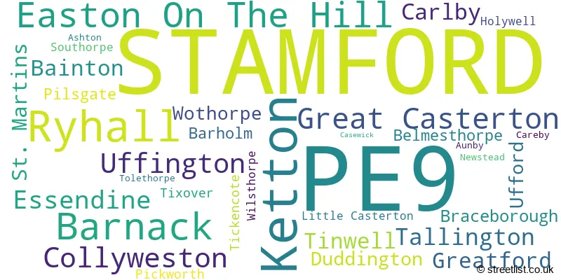
The largest settlement in the PE9 postal code is STAMFORD followed by Ketton, and Tallington.
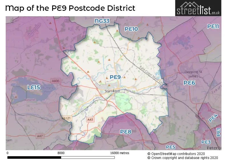
The PE9 Postcode shares a border with LE15 (OAKHAM, Uppingham, Barleythorpe), PE6 (Market Deeping, Deeping St. James, Crowland), PE8 (Oundle, Wittering, Kings Cliffe), NG33 (Colsterworth, South Witham, Corby Glen), NN17 (CORBY, Weldon, Gretton) and PE10 (BOURNE, Morton, Thurlby).
The primary settlement in the PE9 postcode district is Stamford, located in both Cambridgeshire and Lincolnshire counties. Other significant settlements in this district include St. Martins, Ashton, Bainton, Barnack, Collyweston, Duddington, Easton On The Hill, Ketton, Pilsgate, Southorpe, Tinwell, Tixover, Uffington, Ufford, and Wothorpe. The most significant post town in this district is Stamford.
For the district PE9, we have data on 5 postcode sectors. Here's a breakdown: The sector PE9 1, covers Stamford in Lincolnshire. The sector PE9 2, covers Stamford in Lincolnshire. The sector PE9 3, covers Ketton in Rutland. The sector PE9 3, covers Barnack in Cambridgeshire. The sector PE9 3, covers Easton On The Hill in Northamptonshire. The sector PE9 4, covers Ryhall and Great Casterton in Rutland. The sector PE9 9 is non-geographic. It's often designated for PO Boxes, large organisations, or special services.

Map of the PE9 Postcode District
Explore the PE9 postcode district by using our free interactive map.
When it comes to local government, postal geography often disregards political borders. However, for a breakdown in the PE9 District: the district mostly encompasses the South Kesteven District (686 postcodes), followed by the Rutland area (186 postcodes), followed by the City of Peterborough (B) area (92 postcodes), and finally, the North Northamptonshire area (62 postcodes).
Recent House Sales in PE9
| Date | Price | Address |
|---|---|---|
| 25/10/2023 | £325,000 | Kesteven Road, Stamford, PE9 1SR |
| 17/10/2023 | £235,000 | Masterton Close, Stamford, PE9 1SL |
| 13/10/2023 | £269,950 | Churchill Road, Stamford, PE9 1JG |
| 11/10/2023 | £195,000 | East Street, Stamford, PE9 1QD |
| 10/10/2023 | £470,000 | Canon Drive, Barnack, Stamford, PE9 3EG |
| 06/10/2023 | £390,000 | Caithness Road, Stamford, PE9 2TP |
| 29/09/2023 | £324,000 | Winterton Close, Stamford, PE9 1FE |
| 29/09/2023 | £260,000 | Rutland Road, Stamford, PE9 1UP |
| 27/09/2023 | £260,000 | Cedar Road, Stamford, PE9 2JJ |
| 25/09/2023 | £205,000 | Bentley Street, Stamford, PE9 1EU |
Weather Forecast for PE9
Press Button to Show Forecast for Stamford
| Time Period | Icon | Description | Temperature | Rain Probability | Wind |
|---|---|---|---|---|---|
| 21:00 to 00:00 | Partly cloudy (night) | 5.0°C (feels like 3.0°C) | 1.00% | ENE 4 mph |
Press Button to Show Forecast for Stamford
| Time Period | Icon | Description | Temperature | Rain Probability | Wind |
|---|---|---|---|---|---|
| 00:00 to 03:00 | Clear night | 2.0°C (feels like 0.0°C) | 0.00% | N 4 mph | |
| 03:00 to 06:00 | Clear night | 1.0°C (feels like -1.0°C) | 0.00% | N 4 mph | |
| 06:00 to 09:00 | Sunny day | 2.0°C (feels like 0.0°C) | 1.00% | N 7 mph | |
| 09:00 to 12:00 | Sunny day | 7.0°C (feels like 6.0°C) | 2.00% | NE 7 mph | |
| 12:00 to 15:00 | Cloudy | 9.0°C (feels like 8.0°C) | 8.00% | NE 4 mph | |
| 15:00 to 18:00 | Cloudy | 9.0°C (feels like 8.0°C) | 8.00% | ENE 7 mph | |
| 18:00 to 21:00 | Cloudy | 8.0°C (feels like 6.0°C) | 9.00% | ENE 7 mph | |
| 21:00 to 00:00 | Cloudy | 6.0°C (feels like 4.0°C) | 8.00% | ENE 4 mph |
Press Button to Show Forecast for Stamford
| Time Period | Icon | Description | Temperature | Rain Probability | Wind |
|---|---|---|---|---|---|
| 00:00 to 03:00 | Cloudy | 5.0°C (feels like 3.0°C) | 9.00% | NE 4 mph | |
| 03:00 to 06:00 | Cloudy | 4.0°C (feels like 1.0°C) | 9.00% | NE 4 mph | |
| 06:00 to 09:00 | Cloudy | 5.0°C (feels like 2.0°C) | 11.00% | NE 7 mph | |
| 09:00 to 12:00 | Cloudy | 8.0°C (feels like 6.0°C) | 15.00% | ENE 9 mph | |
| 12:00 to 15:00 | Overcast | 10.0°C (feels like 8.0°C) | 21.00% | ENE 11 mph | |
| 15:00 to 18:00 | Cloudy | 11.0°C (feels like 8.0°C) | 18.00% | ENE 11 mph | |
| 18:00 to 21:00 | Cloudy | 9.0°C (feels like 7.0°C) | 17.00% | ENE 11 mph | |
| 21:00 to 00:00 | Cloudy | 8.0°C (feels like 5.0°C) | 24.00% | NE 11 mph |
Press Button to Show Forecast for Stamford
| Time Period | Icon | Description | Temperature | Rain Probability | Wind |
|---|---|---|---|---|---|
| 00:00 to 03:00 | Light rain | 7.0°C (feels like 4.0°C) | 53.00% | NE 11 mph | |
| 03:00 to 06:00 | Heavy rain | 8.0°C (feels like 5.0°C) | 72.00% | NE 11 mph | |
| 06:00 to 09:00 | Heavy rain | 8.0°C (feels like 6.0°C) | 78.00% | NE 11 mph | |
| 09:00 to 12:00 | Light rain | 11.0°C (feels like 9.0°C) | 55.00% | SSE 11 mph | |
| 12:00 to 15:00 | Heavy rain shower (day) | 12.0°C (feels like 10.0°C) | 57.00% | SSE 9 mph | |
| 15:00 to 18:00 | Heavy rain shower (day) | 11.0°C (feels like 9.0°C) | 61.00% | W 11 mph | |
| 18:00 to 21:00 | Light rain shower (day) | 10.0°C (feels like 8.0°C) | 37.00% | SW 11 mph | |
| 21:00 to 00:00 | Partly cloudy (night) | 8.0°C (feels like 6.0°C) | 7.00% | NNE 7 mph |
Where is the PE9 Postcode District?
The data postcode district, PE9, is located in Stamford. Stamford is situated near the towns of Bourne to the North East, Oakham to the West, Peterborough to the South East, Corby to the South West, and Grantham to the North. Additionally, Stamford is approximately 81.3 miles away from the center of London.
The district is within the post town of STAMFORD.
The sector has postcodes within the nation of England.
The PE9 Postcode District is covers the following regions.
- Lincolnshire - Lincolnshire - East Midlands (England)
- Peterborough - East Anglia - East of England
- North Northamptonshire - Leicestershire, Rutland and Northamptonshire - East Midlands (England)
- Leicestershire CC and Rutland - Leicestershire, Rutland and Northamptonshire - East Midlands (England)
| Postcode Sector | Delivery Office |
|---|---|
| PE9 1 | Stamford Delivery Office |
| PE9 2 | Stamford Delivery Office |
| PE9 3 | Stamford Delivery Office |
| PE9 3 | Easton On The Hill Scale Payment Delivery Office |
| PE9 3 | Ketton Scale Payment Delivery Office |
| PE9 4 | Stamford Delivery Office |
| PE9 4 | Ryhall Scale Payment Delivery Office |
| P | E | 9 | - | X | X | X |
| P | E | 9 | Space | Numeric | Letter | Letter |
Current Monthly Rental Prices
| # Bedrooms | Min Price | Max Price | Avg Price |
|---|---|---|---|
| £150 | £150 | £150 | |
| 1 | £110 | £1,100 | £676 |
| 2 | £795 | £1,255 | £986 |
| 3 | £900 | £3,900 | £1,407 |
| 4 | £1,450 | £2,500 | £1,891 |
| 5 | £2,200 | £4,200 | £3,200 |
Current House Prices
| # Bedrooms | Min Price | Max Price | Avg Price |
|---|---|---|---|
| £150,000 | £800,000 | £344,000 | |
| 1 | £94,950 | £475,000 | £172,161 |
| 2 | £65,000 | £540,000 | £236,625 |
| 3 | £130,000 | £1,095,000 | £365,874 |
| 4 | £170,000 | £1,375,000 | £604,165 |
| 5 | £425,000 | £2,500,000 | £1,018,333 |
| 6 | £635,000 | £1,800,000 | £1,196,000 |
| 7 | £2,600,000 | £2,950,000 | £2,833,333 |
| 8 | £1,350,000 | £1,350,000 | £1,350,000 |
Estate Agents who Operate in the PE9 District
| Logo | Name | Brand Name | Address | Contact Number | Total Properties |
|---|---|---|---|---|---|
 | Stamford | Newton Fallowell | 4 Ironmonger Street, Stamford, PE9 1PL | 01780 432716 | 73 |
 | Stamford | Sowden Wallis Estate Agents | 8-9 Star Lane Stamford PE9 1PH | 01780 431524 | 26 |
 | Stamford | Goodwin Property Services | 2/3 St. Johns Street Stamford PE9 2DA | 01780 431636 | 26 |
 | Stamford | Hurfords | 38 St. Marys Street, Stamford, PE9 2DS | 01780 431573 | 25 |
 | Stamford | Knight Partnership | 3 Red Lion Street, Stamford, PE9 1PA | 01780 432732 | 21 |
- Ashton
- Bainton
- Barnack
- Belmesthorpe
- Braceborough
- Careby
- Carlby
- Collyweston
- Duddington
- Easton on the Hill
- Empingham
- Essendine
- Great Casterton
- Greatford
- Ketton
- Little Bytham
- Little Casterton
- Normanton
- Peterborough
- Pickworth
- Pilsgate
- Ryhall
- Southorpe
- Stamford
- Tallington
- Tickencote
- Tinwell
- Uffington
- Ufford
- Wittering
- Wothorpe
| Type of Property | 2018 Average | 2018 Sales | 2017 Average | 2017 Sales | 2016 Average | 2016 Sales | 2015 Average | 2015 Sales |
|---|---|---|---|---|---|---|---|---|
| Detached | £459,740 | 247 | £437,333 | 263 | £443,029 | 213 | £389,389 | 218 |
| Semi-Detached | £283,159 | 192 | £258,970 | 189 | £245,931 | 194 | £231,467 | 160 |
| Terraced | £311,079 | 205 | £305,498 | 191 | £264,510 | 204 | £226,520 | 224 |
| Flats | £186,974 | 42 | £166,961 | 64 | £183,830 | 85 | £143,513 | 59 |