The PE9 1 postcode sector stands on the Lincolnshire and Rutland border.
Did you know? According to the 2021 Census, the PE9 1 postcode sector is home to a bustling 9,452 residents!
Given that each sector allows for 400 unique postcode combinations. Letters C, I, K, M, O and V are not allowed in the last two letters of a postcode. With 230 postcodes already in use, this leaves 170 units available.
The PE9 1 postal code covers the settlement of STAMFORD.
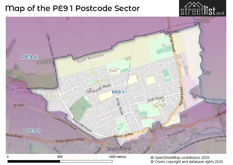
The PE9 1 Postcode shares a border with PE9 2 (STAMFORD, St. Martins) and PE9 4 (Tallington, Ryhall, Great Casterton).
The sector is within the post town of STAMFORD.
PE9 1 is a postcode sector within the PE9 postcode district which is within the PE Peterborough postcode area.
The Royal Mail delivery office for the PE9 1 postal sector is the Stamford Delivery Office.
The area of the PE9 1 postcode sector is 1.15 square miles which is 2.97 square kilometres or 734.82 square acres.
Waterways within the PE9 1 postcode sector include the River Gwash.

Map of the PE9 1 Postcode Sector
Explore the PE9 1 postcode sector by using our free interactive map.
| P | E | 9 | - | 1 | X | X |
| P | E | 9 | Space | 1 | Letter | Letter |
Official List of Streets
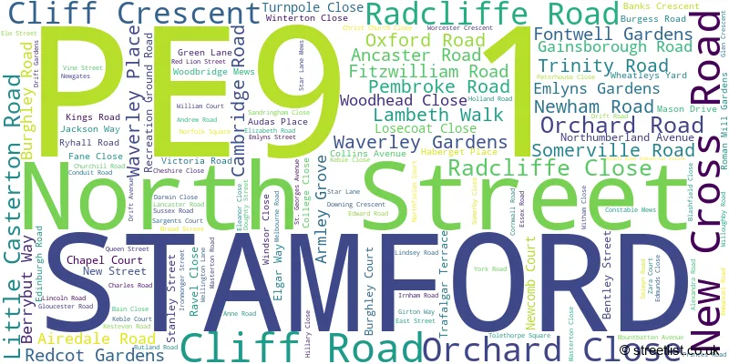
STAMFORD (131 Streets)
Unofficial Streets or Alternative Spellings
Weather Forecast for PE9 1
Press Button to Show Forecast for Stamford
| Time Period | Icon | Description | Temperature | Rain Probability | Wind |
|---|---|---|---|---|---|
| 00:00 to 03:00 | Overcast | 9.0°C (feels like 6.0°C) | 16.00% | W 13 mph | |
| 03:00 to 06:00 | Overcast | 9.0°C (feels like 7.0°C) | 39.00% | WNW 13 mph | |
| 06:00 to 09:00 | Cloudy | 9.0°C (feels like 6.0°C) | 14.00% | WNW 13 mph | |
| 09:00 to 12:00 | Cloudy | 11.0°C (feels like 8.0°C) | 47.00% | NW 16 mph | |
| 12:00 to 15:00 | Cloudy | 11.0°C (feels like 7.0°C) | 12.00% | N 16 mph | |
| 15:00 to 18:00 | Cloudy | 10.0°C (feels like 7.0°C) | 44.00% | N 16 mph | |
| 18:00 to 21:00 | Cloudy | 9.0°C (feels like 6.0°C) | 5.00% | N 11 mph | |
| 21:00 to 00:00 | Clear night | 6.0°C (feels like 3.0°C) | 2.00% | N 9 mph |
Press Button to Show Forecast for Stamford
| Time Period | Icon | Description | Temperature | Rain Probability | Wind |
|---|---|---|---|---|---|
| 00:00 to 03:00 | Clear night | 4.0°C (feels like 1.0°C) | 1.00% | NNW 9 mph | |
| 03:00 to 06:00 | Partly cloudy (night) | 4.0°C (feels like 0.0°C) | 1.00% | NNW 9 mph | |
| 06:00 to 09:00 | Partly cloudy (day) | 4.0°C (feels like 0.0°C) | 2.00% | NNW 11 mph | |
| 09:00 to 12:00 | Cloudy | 7.0°C (feels like 4.0°C) | 5.00% | N 13 mph | |
| 12:00 to 15:00 | Overcast | 9.0°C (feels like 6.0°C) | 8.00% | N 11 mph | |
| 15:00 to 18:00 | Overcast | 10.0°C (feels like 7.0°C) | 8.00% | N 11 mph | |
| 18:00 to 21:00 | Cloudy | 9.0°C (feels like 7.0°C) | 6.00% | NNE 9 mph | |
| 21:00 to 00:00 | Cloudy | 6.0°C (feels like 5.0°C) | 5.00% | NE 4 mph |
Press Button to Show Forecast for Stamford
| Time Period | Icon | Description | Temperature | Rain Probability | Wind |
|---|---|---|---|---|---|
| 00:00 to 03:00 | Cloudy | 5.0°C (feels like 4.0°C) | 5.00% | NW 4 mph | |
| 03:00 to 06:00 | Overcast | 5.0°C (feels like 3.0°C) | 9.00% | N 4 mph | |
| 06:00 to 09:00 | Overcast | 5.0°C (feels like 3.0°C) | 12.00% | N 4 mph | |
| 09:00 to 12:00 | Overcast | 8.0°C (feels like 6.0°C) | 19.00% | NNE 9 mph | |
| 12:00 to 15:00 | Overcast | 9.0°C (feels like 7.0°C) | 13.00% | NNE 9 mph | |
| 15:00 to 18:00 | Cloudy | 10.0°C (feels like 8.0°C) | 6.00% | NNE 11 mph | |
| 18:00 to 21:00 | Cloudy | 9.0°C (feels like 6.0°C) | 5.00% | NE 9 mph | |
| 21:00 to 00:00 | Cloudy | 6.0°C (feels like 4.0°C) | 6.00% | NNE 7 mph |
Press Button to Show Forecast for Stamford
| Time Period | Icon | Description | Temperature | Rain Probability | Wind |
|---|---|---|---|---|---|
| 00:00 to 03:00 | Cloudy | 5.0°C (feels like 3.0°C) | 6.00% | NNE 7 mph | |
| 03:00 to 06:00 | Partly cloudy (night) | 5.0°C (feels like 2.0°C) | 2.00% | N 7 mph | |
| 06:00 to 09:00 | Cloudy | 5.0°C (feels like 3.0°C) | 5.00% | N 7 mph | |
| 09:00 to 12:00 | Cloudy | 9.0°C (feels like 7.0°C) | 6.00% | NNE 9 mph | |
| 12:00 to 15:00 | Cloudy | 10.0°C (feels like 8.0°C) | 6.00% | NE 11 mph | |
| 15:00 to 18:00 | Cloudy | 10.0°C (feels like 7.0°C) | 12.00% | NE 11 mph | |
| 18:00 to 21:00 | Partly cloudy (day) | 9.0°C (feels like 6.0°C) | 3.00% | NE 9 mph | |
| 21:00 to 00:00 | Cloudy | 6.0°C (feels like 4.0°C) | 7.00% | NNE 7 mph |
Schools and Places of Education Within the PE9 1 Postcode Sector
St Augustine's Catholic Voluntary Academy
Academy converter
Kesteven Road, Stamford, Lincolnshire, PE9 1SR
Head: Mrs Tina Cox
Ofsted Rating: Requires improvement
Inspection: 2022-09-28 (569 days ago)
Website: Visit St Augustine's Catholic Voluntary Academy Website
Phone: 01780762094
Number of Pupils: 96
St George's Church of England Aided Primary School
Voluntary aided school
Kesteven Road, Stamford, Lincolnshire, PE9 1SX
Head: Mrs Laura Martin
Ofsted Rating: Good
Inspection: 2018-12-05 (1962 days ago)
Website: Visit St George's Church of England Aided Primary School Website
Phone: 01780763654
Number of Pupils: 186
Stamford Welland Academy
Academy converter
Green Lane, Stamford, Lincolnshire, PE9 1HE
Head: Mrs Victoria Lloyd
Ofsted Rating: Good
Inspection: 2021-09-22 (940 days ago)
Website: Visit Stamford Welland Academy Website
Phone: 01780761000
Number of Pupils: 558
The Bluecoat School
Academy converter
Green Lane, Stamford, Lincolnshire, PE9 1HE
Head: Mrs Emma Houlton
Ofsted Rating: Requires improvement
Inspection: 2022-03-31 (750 days ago)
Website: Visit The Bluecoat School Website
Phone: 01780764202
Number of Pupils: 188
House Prices in the PE9 1 Postcode Sector
| Type of Property | 2018 Average | 2018 Sales | 2017 Average | 2017 Sales | 2016 Average | 2016 Sales | 2015 Average | 2015 Sales |
|---|---|---|---|---|---|---|---|---|
| Detached | £351,235 | 17 | £331,914 | 29 | £324,412 | 17 | £373,192 | 26 |
| Semi-Detached | £248,420 | 71 | £229,022 | 64 | £200,089 | 61 | £199,727 | 51 |
| Terraced | £241,878 | 92 | £217,016 | 77 | £209,319 | 90 | £187,930 | 107 |
| Flats | £128,618 | 17 | £103,300 | 21 | £116,576 | 25 | £110,725 | 30 |
Important Postcodes PE9 1 in the Postcode Sector
PE9 1AD is the postcode for Lincolnshire Police, Police Station, North Street
PE9 1AP is the postcode for Lincolnshire Fire & Rescue Service, Fire Station, Radcliffe Road
PE9 1HE is the postcode for The Bluecoat Primary School, Green Lane, Stamford Welland Academy, Green Lane, and STAMFORD WELLAND ACADEMY, GREEN LANE, STAMFORD
PE9 1SR is the postcode for St AugustineG��s Catholic Voluntary Academy, Kesteven Road, and St. Augustines RC Primary School, Kesteven Road
PE9 1SX is the postcode for St. Georges School, Kesteven Road, ST GEORGES C OF E SCHOOL, KESTEVEN ROAD, STAMFORD, and St Georges C Of E School, Kesteven Road
PE9 1UA is the postcode for Stamford And Rutland Hospital, Ryhall Road, Stamford & Rutland Hospital, Ryhall Road, and Peterborough and Stamford Hospitals NHS Foundation Trust, Stamford & Rutland Hospital
PE9 1UF is the postcode for Stamford Day Centre, 33 Ryhall Road
PE9 1UN is the postcode for Lincolnshire Partnership NHS Foundation Trust, Stamford Resource Centre, St. Georges Avenue, Lincolnshire Partnership NHS Foundation Trust, Stamford Resource Centre, and Stamford Resource Centre, St Georges Avenue
PE9 1US is the postcode for Borderville Sports Centre, Ryhall Road
PE9 1XA is the postcode for Block 8, Stamford College, Drift Road, MAIN BUILDING, New College Stamford, Drift Road, Stamford Leisure Centre, Drift Road, Stamford College Blocks 0,1,2,3,5,6,7,9, Drift Road, New College Stamford, Drift Road, and CATERING & SCIENCE BLOCK, New College Stamford, Drift Road
PE9 1XP is the postcode for Unit 44, Gwash Way Industrial Estate
PE9 1YA is the postcode for The Sheepmarket Surgery, Ryhall Road
| The PE9 1 Sector is within these Local Authorities |
|
|---|---|
| The PE9 1 Sector is within these Counties |
|
| The PE9 1 Sector is within these Water Company Areas |
|