The PH10 postcode district is a postal district located in the PH Perth postcode area with a population of 11,050 residents according to the 2011 Scotland Census.
The area of the PH10 postcode district is 211.25 square miles which is 547.14 square kilometres or 135,200.78 acres.
Currently, the PH10 district has about 464 postcode units spread across 2 geographic postcode sectors.
Given that each sector allows for 400 unique postcode combinations, the district has a capacity of 800 postcodes. With 464 postcodes already in use, this leaves 336 units available.
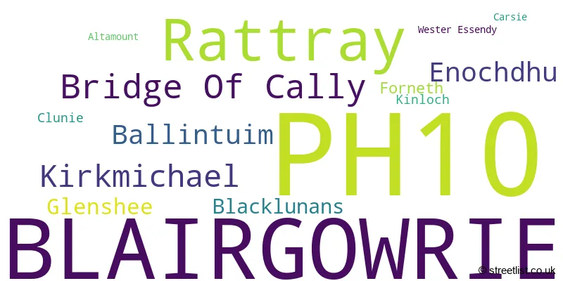
The largest settlement in the PH10 postal code is BLAIRGOWRIE followed by Rattray, and Bridge Of Cally.
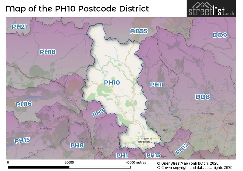
The PH10 Postcode shares a border with PH1 (PERTH, Stanley, Methven), PH8 (DUNKELD, Birnam, Amulree), PH11 (Alyth, Glenisla, Kilry), PH13 (Coupar Angus, Burrelton, Kettins), PH9 (Ballinluig, Strathtay, Logierait), PH2 (PERTH, Scone, Bridge Of Earn), PH18 (Blair Atholl, Calvine, Bridge Of Tilt) and AB35 (BALLATER, Braemar, Crathie).
In the PH10 postcode district of Perth and Kinross, the primary settlement is Blairgowrie. Other significant settlements in this postcode district include Altamount, Carsie, Clunie, Forneth, Kinloch, and Wester Essendy. The most significant post town in this district is Blairgowrie, which is located in the county of Perth and Kinross in Scotland.
For the district PH10, we have data on 3 postcode sectors. Here's a breakdown: The sector PH10 6, covers Blairgowrie in Perth and Kinross. The sector PH10 7, covers Rattray and Bridge Of Cally in Perth and Kinross. The sector PH10 9 is non-geographic. It's often designated for PO Boxes, large organisations, or special services.

Map of the PH10 Postcode District
Explore the PH10 postcode district by using our free interactive map.
When it comes to local government, postal geography often disregards political borders. However, for a breakdown in the PH10 District: the district mostly encompasses the Perth and Kinross area with a total of 474 postcodes.
Weather Forecast for PH10
Press Button to Show Forecast for Creag Leacach
| Time Period | Icon | Description | Temperature | Rain Probability | Wind |
|---|---|---|---|---|---|
| 12:00 to 15:00 | Overcast | 0.0°C (feels like -7.0°C) | 8.00% | N 25 mph | |
| 15:00 to 18:00 | Partly cloudy (day) | 2.0°C (feels like -6.0°C) | 0.00% | N 29 mph | |
| 18:00 to 21:00 | Cloudy | 1.0°C (feels like -6.0°C) | 4.00% | N 27 mph | |
| 21:00 to 00:00 | Cloudy | -1.0°C (feels like -10.0°C) | 7.00% | N 29 mph |
Press Button to Show Forecast for Creag Leacach
| Time Period | Icon | Description | Temperature | Rain Probability | Wind |
|---|---|---|---|---|---|
| 00:00 to 03:00 | Partly cloudy (night) | -3.0°C (feels like -12.0°C) | 3.00% | N 29 mph | |
| 03:00 to 06:00 | Partly cloudy (night) | -4.0°C (feels like -13.0°C) | 2.00% | N 29 mph | |
| 06:00 to 09:00 | Partly cloudy (day) | -4.0°C (feels like -13.0°C) | 1.00% | N 25 mph | |
| 09:00 to 12:00 | Partly cloudy (day) | -2.0°C (feels like -9.0°C) | 1.00% | N 18 mph | |
| 12:00 to 15:00 | Sunny day | 0.0°C (feels like -5.0°C) | 0.00% | N 16 mph | |
| 15:00 to 18:00 | Sunny day | 2.0°C (feels like -3.0°C) | 0.00% | NNW 18 mph | |
| 18:00 to 21:00 | Partly cloudy (day) | 2.0°C (feels like -4.0°C) | 0.00% | NNW 18 mph | |
| 21:00 to 00:00 | Cloudy | -1.0°C (feels like -7.0°C) | 11.00% | NNW 16 mph |
Press Button to Show Forecast for Creag Leacach
| Time Period | Icon | Description | Temperature | Rain Probability | Wind |
|---|---|---|---|---|---|
| 00:00 to 03:00 | Overcast | -2.0°C (feels like -10.0°C) | 10.00% | NNW 22 mph | |
| 03:00 to 06:00 | Overcast | -3.0°C (feels like -10.0°C) | 12.00% | NNW 22 mph | |
| 06:00 to 09:00 | Light snow | -3.0°C (feels like -10.0°C) | 55.00% | N 18 mph | |
| 09:00 to 12:00 | Overcast | -2.0°C (feels like -8.0°C) | 10.00% | N 13 mph | |
| 12:00 to 15:00 | Overcast | 0.0°C (feels like -5.0°C) | 8.00% | NNE 11 mph | |
| 15:00 to 18:00 | Overcast | 1.0°C (feels like -4.0°C) | 9.00% | NNE 9 mph | |
| 18:00 to 21:00 | Light snow | 0.0°C (feels like -4.0°C) | 53.00% | ENE 7 mph | |
| 21:00 to 00:00 | Cloudy | -3.0°C (feels like -7.0°C) | 12.00% | E 7 mph |
Press Button to Show Forecast for Creag Leacach
| Time Period | Icon | Description | Temperature | Rain Probability | Wind |
|---|---|---|---|---|---|
| 00:00 to 03:00 | Cloudy | -4.0°C (feels like -8.0°C) | 11.00% | ENE 7 mph | |
| 03:00 to 06:00 | Overcast | -4.0°C (feels like -8.0°C) | 9.00% | ENE 7 mph | |
| 06:00 to 09:00 | Cloudy | -4.0°C (feels like -7.0°C) | 5.00% | ENE 7 mph | |
| 09:00 to 12:00 | Overcast | -2.0°C (feels like -5.0°C) | 10.00% | E 7 mph | |
| 12:00 to 15:00 | Overcast | 0.0°C (feels like -3.0°C) | 10.00% | E 7 mph | |
| 15:00 to 18:00 | Light snow | 0.0°C (feels like -3.0°C) | 55.00% | E 7 mph | |
| 18:00 to 21:00 | Light snow | -1.0°C (feels like -5.0°C) | 54.00% | E 7 mph | |
| 21:00 to 00:00 | Cloudy | -3.0°C (feels like -7.0°C) | 11.00% | ESE 7 mph |
Press Button to Show Forecast for Creag Leacach
| Time Period | Icon | Description | Temperature | Rain Probability | Wind |
|---|---|---|---|---|---|
| 00:00 to 03:00 | Cloudy | -4.0°C (feels like -8.0°C) | 9.00% | SE 7 mph | |
| 03:00 to 06:00 | Cloudy | -4.0°C (feels like -8.0°C) | 11.00% | NE 9 mph | |
| 06:00 to 09:00 | Light snow | -3.0°C (feels like -8.0°C) | 54.00% | N 9 mph | |
| 09:00 to 12:00 | Light snow | -1.0°C (feels like -5.0°C) | 55.00% | ESE 9 mph | |
| 12:00 to 15:00 | Light snow | 1.0°C (feels like -4.0°C) | 49.00% | ESE 11 mph | |
| 15:00 to 18:00 | Light snow | 1.0°C (feels like -4.0°C) | 58.00% | SE 13 mph | |
| 18:00 to 21:00 | Light snow | 0.0°C (feels like -5.0°C) | 60.00% | ESE 13 mph | |
| 21:00 to 00:00 | Light snow | -2.0°C (feels like -7.0°C) | 53.00% | E 13 mph |
Where is the PH10 Postcode District?
The postcode district for PH10 is located in Blairgowrie. Blairgowrie is nearby to several towns, including Dunkeld in the South West (12.46 miles away), Edinburgh in the South East (13.06 miles away), Pitlochry in the West (15.17 miles away), Kirriemuir in the East (16.59 miles away), and Perth in the South (23.54 miles away). Additionally, Blairgowrie is located approximately 386.74 miles away from the center of London.
The district is within the post town of BLAIRGOWRIE.
The sector has postcodes within the nation of Scotland.
The PH10 Postcode District is in the region of within the .
| Postcode Sector | Delivery Office |
|---|---|
| PH10 6 | Blairgowrie Delivery Office |
| PH10 7 | Blairgowrie Delivery Office |
| P | H | 1 | 0 | - | X | X | X |
| P | H | 1 | 0 | Space | Numeric | Letter | Letter |
Current Monthly Rental Prices
| # Bedrooms | Min Price | Max Price | Avg Price |
|---|---|---|---|
| 2 | £575 | £575 | £575 |
| 3 | £1,350 | £1,350 | £1,350 |
Current House Prices
| # Bedrooms | Min Price | Max Price | Avg Price |
|---|---|---|---|
| £30,000 | £1,750,000 | £444,158 | |
| 1 | £110,000 | £110,000 | £110,000 |
| 2 | £79,950 | £210,000 | £159,817 |
| 3 | £109,950 | £475,000 | £263,588 |
| 4 | £230,000 | £335,000 | £300,434 |
| 5 | £259,950 | £395,000 | £327,475 |
| 7 | £695,000 | £695,000 | £695,000 |
| 8 | £299,950 | £299,950 | £299,950 |
Estate Agents who Operate in the PH10 District
| Logo | Name | Brand Name | Address | Contact Number | Total Properties |
|---|---|---|---|---|---|
 | Perth | Simple Approach Estate Agents | 13-15 St. Leonards Bridge, Perth, PH2 0DR | 01738 505880 | 9 |
 | Perth | Next Home | 63-65 George Street, Perth, PH1 5LB | 01738 505870 | 6 |
 | Perth | Ballantynes | 28 York Place, Perth, PH2 8EH | 01738 505926 | 5 |
 | Perth | Possible Estate Agents | 6 Auld Bond Road, Perth PH1 3FX | 01738 503339 | 5 |
 | Perth | Aberdein Considine | 74 High Street, Perth PH1 5TH | 01738 505877 | 3 |