The PH17 postcode district is a postal district located in the PH Perth postcode area with a population of 224 residents according to the 2011 Scotland Census.
The area of the PH17 postcode district is 207.26 square miles which is 536.80 square kilometres or 132,644.84 acres.
Currently, the PH17 district has about 13 postcode units spread across 0 geographic postcode sectors.
Given that each sector allows for 400 unique postcode combinations, the district has a capacity of 0 postcodes. With 13 postcodes already in use, this leaves -13 units available.
The PH17 postal code covers the settlement of Rannoch.
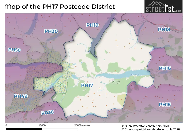
The PH17 Postcode shares a border with PH15 (ABERFELDY, Glenlyon, Kenmore), PH19 (DALWHINNIE) and PH49 (Glencoe, BALLACHULISH, Glenetive).
The primary settlement in the PH17 postcode district is Rannoch, located in the county of Perth and Kinross, Scotland. The main post town for this postcode district is Pitlochry.
For the district PH17, we have data on 1 postcode sectors. Here's a breakdown: The sector PH17 2 is non-geographic. It's often designated for PO Boxes, large organisations, or special services.
PH17 Postcode Sectors


Map of the PH17 Postcode District
Explore the PH17 postcode district by using our free interactive map.
When it comes to local government, postal geography often disregards political borders. However, for a breakdown in the PH17 District: the district mostly encompasses the Perth and Kinross area with a total of 13 postcodes.
Weather Forecast for PH17
Press Button to Show Forecast for Finnart
| Time Period | Icon | Description | Temperature | Rain Probability | Wind |
|---|---|---|---|---|---|
| 00:00 to 03:00 | Clear night | 4.0°C (feels like 2.0°C) | 0.00% | ENE 4 mph | |
| 03:00 to 06:00 | Clear night | 2.0°C (feels like -1.0°C) | 0.00% | NE 4 mph | |
| 06:00 to 09:00 | Partly cloudy (day) | 2.0°C (feels like 0.0°C) | 0.00% | NNE 4 mph | |
| 09:00 to 12:00 | Sunny day | 5.0°C (feels like 3.0°C) | 0.00% | NNW 4 mph | |
| 12:00 to 15:00 | Sunny day | 8.0°C (feels like 7.0°C) | 0.00% | N 4 mph | |
| 15:00 to 18:00 | Sunny day | 10.0°C (feels like 8.0°C) | 0.00% | NNW 7 mph | |
| 18:00 to 21:00 | Sunny day | 9.0°C (feels like 7.0°C) | 0.00% | NW 9 mph | |
| 21:00 to 00:00 | Partly cloudy (night) | 6.0°C (feels like 4.0°C) | 1.00% | WNW 7 mph |
Press Button to Show Forecast for Finnart
| Time Period | Icon | Description | Temperature | Rain Probability | Wind |
|---|---|---|---|---|---|
| 00:00 to 03:00 | Partly cloudy (night) | 4.0°C (feels like 2.0°C) | 1.00% | NW 4 mph | |
| 03:00 to 06:00 | Cloudy | 3.0°C (feels like 1.0°C) | 10.00% | NNW 7 mph | |
| 06:00 to 09:00 | Overcast | 3.0°C (feels like 1.0°C) | 11.00% | NNW 7 mph | |
| 09:00 to 12:00 | Cloudy | 5.0°C (feels like 3.0°C) | 17.00% | N 7 mph | |
| 12:00 to 15:00 | Cloudy | 7.0°C (feels like 5.0°C) | 7.00% | NNE 7 mph | |
| 15:00 to 18:00 | Overcast | 8.0°C (feels like 7.0°C) | 8.00% | NE 4 mph | |
| 18:00 to 21:00 | Cloudy | 7.0°C (feels like 5.0°C) | 6.00% | ENE 7 mph | |
| 21:00 to 00:00 | Cloudy | 4.0°C (feels like 2.0°C) | 6.00% | E 4 mph |
Press Button to Show Forecast for Finnart
| Time Period | Icon | Description | Temperature | Rain Probability | Wind |
|---|---|---|---|---|---|
| 00:00 to 03:00 | Cloudy | 3.0°C (feels like 1.0°C) | 7.00% | E 2 mph | |
| 03:00 to 06:00 | Cloudy | 2.0°C (feels like 0.0°C) | 6.00% | NE 2 mph | |
| 06:00 to 09:00 | Cloudy | 2.0°C (feels like 1.0°C) | 5.00% | NE 4 mph | |
| 09:00 to 12:00 | Overcast | 5.0°C (feels like 3.0°C) | 11.00% | ENE 4 mph | |
| 12:00 to 15:00 | Overcast | 7.0°C (feels like 5.0°C) | 12.00% | E 4 mph | |
| 15:00 to 18:00 | Overcast | 7.0°C (feels like 6.0°C) | 13.00% | ENE 4 mph | |
| 18:00 to 21:00 | Light rain | 6.0°C (feels like 5.0°C) | 51.00% | ESE 4 mph | |
| 21:00 to 00:00 | Partly cloudy (night) | 4.0°C (feels like 2.0°C) | 12.00% | E 4 mph |
Press Button to Show Forecast for Finnart
| Time Period | Icon | Description | Temperature | Rain Probability | Wind |
|---|---|---|---|---|---|
| 00:00 to 03:00 | Cloudy | 2.0°C (feels like 0.0°C) | 7.00% | ENE 4 mph | |
| 03:00 to 06:00 | Cloudy | 1.0°C (feels like 0.0°C) | 7.00% | ENE 2 mph | |
| 06:00 to 09:00 | Cloudy | 2.0°C (feels like 0.0°C) | 10.00% | ENE 4 mph | |
| 09:00 to 12:00 | Cloudy | 5.0°C (feels like 3.0°C) | 12.00% | E 4 mph | |
| 12:00 to 15:00 | Overcast | 7.0°C (feels like 5.0°C) | 17.00% | E 7 mph | |
| 15:00 to 18:00 | Overcast | 8.0°C (feels like 6.0°C) | 16.00% | ESE 7 mph | |
| 18:00 to 21:00 | Cloudy | 7.0°C (feels like 5.0°C) | 20.00% | E 7 mph | |
| 21:00 to 00:00 | Cloudy | 5.0°C (feels like 3.0°C) | 11.00% | E 4 mph |
Where is the PH17 Postcode District?
The postcode district PH17 is located in Pitlochry, which is a district town. It is situated in the northwestern part of Scotland. Pitlochry is surrounded by several nearby towns. To the northwest is Corrour, which is approximately 9.4 miles away. To the south is Killin, which is around 15.7 miles away. In the north, you will find Dalwhinnie, which is about 16.3 miles away. Bridge of Orchy is located in the southwest, approximately 17.8 miles away. Aberfeldy is situated in the southeast, at a distance of approximately 19 miles. Lastly, in the west lies Kinlochleven, around 21.8 miles away. It is worth noting that Pitlochry is approximately 398.8 miles away from the center of London.
The district is within the post town of PITLOCHRY.
The sector has postcodes within the nation of Scotland.
The PH17 Postcode District is in the region of within the .
Postcode Sectors within the PH17 District
| Postcode Sector | Delivery Office |
|---|---|
| PH17 2 | Pitlochry Delivery Office |
| P | H | 1 | 7 | - | X | X | X |
| P | H | 1 | 7 | Space | Numeric | Letter | Letter |
Current Monthly Rental Prices
| # Bedrooms | Min Price | Max Price | Avg Price |
|---|
Current House Prices
| # Bedrooms | Min Price | Max Price | Avg Price |
|---|
Estate Agents who Operate in the PH17 District
| Logo | Name | Brand Name | Address | Contact Number | Total Properties |
|---|