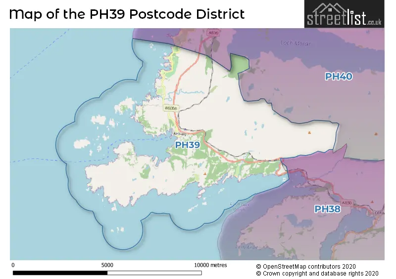
The PH39 postcode district is a postal district located in the PH Perth postcode area with a population of 336 residents according to the 2011 Scotland Census.
The area of the PH39 postcode district is 19.75 square miles which is 51.14 square kilometres or 12,637.18 acres.
Currently, the PH39 district has about 13 postcode units spread across 1 geographic postcode sectors.
Given that each sector allows for 400 unique postcode combinations, the district has a capacity of 400 postcodes. With 13 postcodes already in use, this leaves 387 units available.
The PH39 postal code covers the settlement of ARISAIG.
The postcode area has a boundary with Sea of the Hebredes.
The PH39 Postcode shares a border with PH38 (LOCHAILORT, Kinlochmoidart, Glenuig) and PH40 (Morar).
In the PH39 postcode district, the primary settlement is Arisaig, located in the county of Inverness, Scotland. The most significant post town in this postcode district is also Arisaig.
For the district PH39, we have data on 1 postcode sectors. Here's a breakdown: The sector PH39 4, covers Arisaig in Inverness.
PH39 Postcode Sectors

Map of the PH39 Postcode District
Explore the PH39 postcode district by using our free interactive map.
When it comes to local government, postal geography often disregards political borders. However, for a breakdown in the PH39 District: the district mostly encompasses the Highland area with a total of 14 postcodes.
Weather Forecast for PH39
Press Button to Show Forecast for Arisaig
| Time Period | Icon | Description | Temperature | Rain Probability | Wind |
|---|---|---|---|---|---|
| 18:00 to 21:00 | Cloudy | 8.0°C (feels like 5.0°C) | 6.00% | N 11 mph | |
| 21:00 to 00:00 | Cloudy | 6.0°C (feels like 3.0°C) | 4.00% | NNE 7 mph |
Press Button to Show Forecast for Arisaig
| Time Period | Icon | Description | Temperature | Rain Probability | Wind |
|---|---|---|---|---|---|
| 00:00 to 03:00 | Clear night | 4.0°C (feels like 2.0°C) | 0.00% | NE 4 mph | |
| 03:00 to 06:00 | Partly cloudy (night) | 3.0°C (feels like 1.0°C) | 1.00% | NE 4 mph | |
| 06:00 to 09:00 | Sunny day | 4.0°C (feels like 2.0°C) | 1.00% | NNE 4 mph | |
| 09:00 to 12:00 | Sunny day | 7.0°C (feels like 5.0°C) | 2.00% | NNE 7 mph | |
| 12:00 to 15:00 | Cloudy | 9.0°C (feels like 6.0°C) | 35.00% | NNW 9 mph | |
| 15:00 to 18:00 | Light rain | 8.0°C (feels like 6.0°C) | 38.00% | NNW 9 mph | |
| 18:00 to 21:00 | Partly cloudy (day) | 8.0°C (feels like 5.0°C) | 4.00% | N 9 mph | |
| 21:00 to 00:00 | Partly cloudy (night) | 5.0°C (feels like 3.0°C) | 0.00% | N 7 mph |
Press Button to Show Forecast for Arisaig
| Time Period | Icon | Description | Temperature | Rain Probability | Wind |
|---|---|---|---|---|---|
| 00:00 to 03:00 | Cloudy | 4.0°C (feels like 3.0°C) | 4.00% | N 4 mph | |
| 03:00 to 06:00 | Cloudy | 4.0°C (feels like 2.0°C) | 5.00% | NE 4 mph | |
| 06:00 to 09:00 | Cloudy | 5.0°C (feels like 3.0°C) | 4.00% | NE 4 mph | |
| 09:00 to 12:00 | Cloudy | 8.0°C (feels like 7.0°C) | 8.00% | ENE 4 mph | |
| 12:00 to 15:00 | Cloudy | 8.0°C (feels like 7.0°C) | 21.00% | SE 4 mph | |
| 15:00 to 18:00 | Light rain shower (day) | 8.0°C (feels like 7.0°C) | 32.00% | WNW 7 mph | |
| 18:00 to 21:00 | Light rain shower (day) | 8.0°C (feels like 7.0°C) | 28.00% | N 4 mph | |
| 21:00 to 00:00 | Partly cloudy (night) | 6.0°C (feels like 5.0°C) | 2.00% | NNW 2 mph |
Press Button to Show Forecast for Arisaig
| Time Period | Icon | Description | Temperature | Rain Probability | Wind |
|---|---|---|---|---|---|
| 00:00 to 03:00 | Partly cloudy (night) | 4.0°C (feels like 3.0°C) | 2.00% | N 4 mph | |
| 03:00 to 06:00 | Clear night | 4.0°C (feels like 3.0°C) | 2.00% | NNW 4 mph | |
| 06:00 to 09:00 | Partly cloudy (day) | 5.0°C (feels like 3.0°C) | 4.00% | NNE 2 mph | |
| 09:00 to 12:00 | Partly cloudy (day) | 8.0°C (feels like 6.0°C) | 9.00% | NNW 4 mph | |
| 12:00 to 15:00 | Cloudy | 9.0°C (feels like 8.0°C) | 13.00% | NNW 7 mph | |
| 15:00 to 18:00 | Partly cloudy (day) | 9.0°C (feels like 7.0°C) | 14.00% | NW 9 mph | |
| 18:00 to 21:00 | Sunny day | 9.0°C (feels like 7.0°C) | 9.00% | WNW 9 mph | |
| 21:00 to 00:00 | Partly cloudy (night) | 7.0°C (feels like 5.0°C) | 8.00% | WNW 7 mph |
Where is the PH39 Postcode District?
The postcode district PH39 is located in Arisaig, a town in the western part of Scotland. Arisaig is surrounded by several nearby towns, including Lochailort to the southeast (6.35 miles away), Mallaig to the north (6.40 miles away), Isle of Eigg to the west (12.19 miles away), Acharacle to the south (12.41 miles away), Isle of Rum to the northwest (18.64 miles away), and Fort William to the east (25.36 miles away). Additionally, Arisaig is approximately 438.84 miles from the center of London.
The district is within the post town of ARISAIG.
The sector has postcodes within the nation of Scotland.
The PH39 Postcode District is covers the following regions.
- Caithness & Sutherland and Ross & Cromarty - Highlands and Islands - Scotland
- Inverness & Nairn and Moray, Badenoch & Strathspey - Highlands and Islands - Scotland
- Lochaber, Skye & Lochalsh, Arran & Cumbrae and Argyll & Bute - Highlands and Islands - Scotland
Postcode Sectors within the PH39 District
| Postcode Sector | Delivery Office |
|---|---|
| PH39 4 | Arisaig Scale Payment Delivery Office |
| P | H | 3 | 9 | - | X | X | X |
| P | H | 3 | 9 | Space | Numeric | Letter | Letter |
Current Monthly Rental Prices
| # Bedrooms | Min Price | Max Price | Avg Price |
|---|
Current House Prices
| # Bedrooms | Min Price | Max Price | Avg Price |
|---|---|---|---|
| £125,000 | £285,000 | £181,667 | |
| 2 | £235,000 | £235,000 | £235,000 |
| 3 | £450,000 | £450,000 | £450,000 |
Estate Agents who Operate in the PH39 District
| Logo | Name | Brand Name | Address | Contact Number | Total Properties |
|---|---|---|---|---|---|
 | Fort William | McIntyre & Co | 38 High Street, Fort William, PH33 6AT | 01397 604441 | 3 |
 | Fort William | MacPhee And Partners LLP | Airds House, An Aird, Fort William, PH33 6BL | 01397 609373 | 1 |
 | Oban | Fiuran Property | Belvedere Crannaig-A-Mhinister, Oban, PA34 4LU | 07872 986164 | 1 |