The PH6 postcode district is a postal district located in the PH Perth postcode area with a population of 2,471 residents according to the 2011 Scotland Census.
The area of the PH6 postcode district is 116.51 square miles which is 301.77 square kilometres or 74,568.25 acres.
Currently, the PH6 district has about 114 postcode units spread across 1 geographic postcode sectors.
Given that each sector allows for 400 unique postcode combinations, the district has a capacity of 400 postcodes. With 114 postcodes already in use, this leaves 286 units available.
The largest settlements in the PH6 postal code are Comrie and St. Fillans.
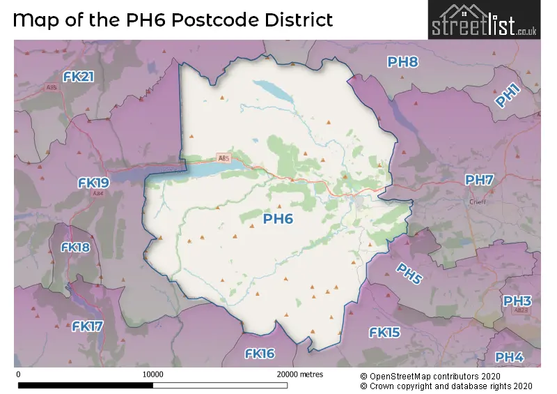
The PH6 Postcode shares a border with PH8 (DUNKELD, Birnam, Amulree), PH7 (CRIEFF, Madderty, Gilmerton), FK15 (DUNBLANE, Braco, Greenloaning), PH15 (ABERFELDY, Glenlyon, Kenmore), FK16 (DOUNE, Deanston, Argaty), FK21 (KILLIN, Glenlochay, Ardeonaig) and PH5 (Muthill).
The primary settlement in the PH6 postcode district is Crieff, which is located in the county of Perth and Kinross in Scotland. The most significant postal town in the district is Crieff as well.
For the district PH6, we have data on 1 postcode sectors. Here's a breakdown: The sector PH6 2, covers Comrie in Perth and Kinross.
PH6 Postcode Sectors


Map of the PH6 Postcode District
Explore the PH6 postcode district by using our free interactive map.
When it comes to local government, postal geography often disregards political borders. However, for a breakdown in the PH6 District: the district mostly encompasses the Perth and Kinross area with a total of 114 postcodes.
Weather Forecast for PH6
Press Button to Show Forecast for St Fillans
| Time Period | Icon | Description | Temperature | Rain Probability | Wind |
|---|---|---|---|---|---|
| 06:00 to 09:00 | Partly cloudy (day) | 3.0°C (feels like 1.0°C) | 0.00% | N 4 mph | |
| 09:00 to 12:00 | Partly cloudy (day) | 6.0°C (feels like 6.0°C) | 0.00% | NW 2 mph | |
| 12:00 to 15:00 | Sunny day | 10.0°C (feels like 9.0°C) | 0.00% | WNW 4 mph | |
| 15:00 to 18:00 | Sunny day | 12.0°C (feels like 11.0°C) | 0.00% | NW 4 mph | |
| 18:00 to 21:00 | Sunny day | 11.0°C (feels like 10.0°C) | 0.00% | NW 4 mph | |
| 21:00 to 00:00 | Partly cloudy (night) | 7.0°C (feels like 5.0°C) | 0.00% | NW 4 mph |
Press Button to Show Forecast for St Fillans
| Time Period | Icon | Description | Temperature | Rain Probability | Wind |
|---|---|---|---|---|---|
| 00:00 to 03:00 | Partly cloudy (night) | 5.0°C (feels like 3.0°C) | 3.00% | WNW 4 mph | |
| 03:00 to 06:00 | Clear night | 3.0°C (feels like 1.0°C) | 2.00% | NNW 4 mph | |
| 06:00 to 09:00 | Cloudy | 4.0°C (feels like 2.0°C) | 5.00% | NW 4 mph | |
| 09:00 to 12:00 | Cloudy | 6.0°C (feels like 4.0°C) | 37.00% | N 7 mph | |
| 12:00 to 15:00 | Cloudy | 8.0°C (feels like 7.0°C) | 7.00% | NNE 7 mph | |
| 15:00 to 18:00 | Cloudy | 9.0°C (feels like 7.0°C) | 7.00% | E 7 mph | |
| 18:00 to 21:00 | Cloudy | 7.0°C (feels like 4.0°C) | 7.00% | E 7 mph | |
| 21:00 to 00:00 | Cloudy | 4.0°C (feels like 2.0°C) | 8.00% | ENE 4 mph |
Press Button to Show Forecast for St Fillans
| Time Period | Icon | Description | Temperature | Rain Probability | Wind |
|---|---|---|---|---|---|
| 00:00 to 03:00 | Cloudy | 3.0°C (feels like 1.0°C) | 5.00% | ENE 4 mph | |
| 03:00 to 06:00 | Cloudy | 2.0°C (feels like 0.0°C) | 19.00% | NE 4 mph | |
| 06:00 to 09:00 | Cloudy | 2.0°C (feels like 1.0°C) | 9.00% | NE 4 mph | |
| 09:00 to 12:00 | Cloudy | 5.0°C (feels like 3.0°C) | 12.00% | ENE 7 mph | |
| 12:00 to 15:00 | Overcast | 7.0°C (feels like 5.0°C) | 13.00% | E 4 mph | |
| 15:00 to 18:00 | Cloudy | 8.0°C (feels like 6.0°C) | 8.00% | E 4 mph | |
| 18:00 to 21:00 | Cloudy | 7.0°C (feels like 5.0°C) | 7.00% | E 4 mph | |
| 21:00 to 00:00 | Partly cloudy (night) | 3.0°C (feels like 1.0°C) | 5.00% | ENE 4 mph |
Press Button to Show Forecast for St Fillans
| Time Period | Icon | Description | Temperature | Rain Probability | Wind |
|---|---|---|---|---|---|
| 00:00 to 03:00 | Cloudy | 2.0°C (feels like 0.0°C) | 10.00% | NE 4 mph | |
| 03:00 to 06:00 | Light rain shower (night) | 1.0°C (feels like -1.0°C) | 29.00% | NE 4 mph | |
| 06:00 to 09:00 | Drizzle | 3.0°C (feels like 1.0°C) | 37.00% | NE 4 mph | |
| 09:00 to 12:00 | Cloudy | 6.0°C (feels like 4.0°C) | 53.00% | ENE 7 mph | |
| 12:00 to 15:00 | Light rain | 8.0°C (feels like 6.0°C) | 43.00% | E 7 mph | |
| 15:00 to 18:00 | Light rain shower (day) | 8.0°C (feels like 6.0°C) | 46.00% | E 7 mph | |
| 18:00 to 21:00 | Cloudy | 7.0°C (feels like 5.0°C) | 17.00% | ENE 7 mph | |
| 21:00 to 00:00 | Cloudy | 5.0°C (feels like 3.0°C) | 14.00% | NE 7 mph |
Where is the PH6 Postcode District?
The postcode district for PH6 is located in Crieff. Crieff is nearby several towns including Lochearnhead to the west, Callander to the southwest, Doune to the south, Killin to the northwest, Inverurie to the southeast, Auchterarder to the east, and Aberfeldy to the north. Additionally, the distance from Crieff to the center of London is approximately 372.9 miles.
The district is within the post town of CRIEFF.
The sector has postcodes within the nation of Scotland.
The PH6 Postcode District is in the region of within the .
Postcode Sectors within the PH6 District
| Postcode Sector | Delivery Office |
|---|---|
| PH6 2 | Crieff Delivery Office |
| P | H | 6 | - | X | X | X |
| P | H | 6 | Space | Numeric | Letter | Letter |
Current Monthly Rental Prices
| # Bedrooms | Min Price | Max Price | Avg Price |
|---|
Current House Prices
| # Bedrooms | Min Price | Max Price | Avg Price |
|---|---|---|---|
| 2 | £34,995 | £200,000 | £134,499 |
| 3 | £109,000 | £109,000 | £109,000 |
Estate Agents who Operate in the PH6 District
| Logo | Name | Brand Name | Address | Contact Number | Total Properties |
|---|---|---|---|---|---|
 | Stirling | YOUR MOVE | 55 Port Street, Stirling, FK8 2EW | 01786 231711 | 4 |
 | Auchterarder | Halliday Properties (Auchterarder) | 41a High Street, Auchterarder, PH3 1PB | 01764 915853 | 2 |
 | Crieff | Irving Geddes W.S. | 25 West High Street, Crieff, PH7 4AU | 01764 915796 | 1 |
 | Dundee | Remax Real Estate Centre Dundee | River Court 5 West Victoria Dock Road, Dundee, DD1 3JT | 01382 919562 | 1 |