The PL20 postcode district is a postal district located in the PL Plymouth postcode area with a population of 12,388 residents according to the 2021 England and Wales Census.
The area of the PL20 postcode district is 115.12 square miles which is 298.16 square kilometres or 73,677.02 acres.
Currently, the PL20 district has about 501 postcode units spread across 2 geographic postcode sectors.
Given that each sector allows for 400 unique postcode combinations, the district has a capacity of 800 postcodes. With 501 postcodes already in use, this leaves 299 units available.
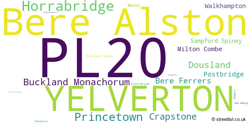
The largest settlement in the PL20 postal code is Bere Alston followed by YELVERTON, and Horrabridge.
The postcode area has a boundary with Plymouth Sound.
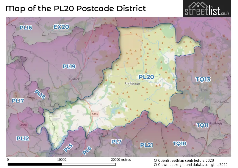
The PL20 Postcode shares a border with TQ13 (Bovey Tracey, Chudleigh, Ashburton), PL18 (GUNNISLAKE, CALSTOCK, St. Anns Chapel), PL19 (TAVISTOCK, Mary Tavy, Whitchurch), PL6 (PLYMOUTH, Derriford, Roborough), PL5 (PLYMOUTH, Tamerton Foliot, Higher St. Budeaux), TQ10 (SOUTH BRENT, Rattery, Avonwick), PL21 (IVYBRIDGE, Modbury, Cornwood) and PL7 (PLYMOUTH, Plympton, Sparkwell).
The primary settlement in the PL20 postcode district is Yelverton, located in Devon. Other significant settlements in the district include Buckland Abbey, Buckland Monachorum, Clearbrook, Dousland, Hoo Meavy, Lovaton, Meavy, Milton Combe, Postbridge, Princetown, Sampford Spiney, Sheepstor, Two Bridges, Walkhampton, Bere Alston, Bere Ferrers, Crapstone, Doublewaters, and Horrabridge. The most significant post town in the district is Yelverton.
For the district PL20, we have data on 2 postcode sectors. Here's a breakdown: The sector PL20 6, covers Yelverton and Princetown and Dousland in Devon. The sector PL20 7, covers Bere Alston and Horrabridge and Buckland Monachorum and Crapstone in Devon.

Map of the PL20 Postcode District
Explore the PL20 postcode district by using our free interactive map.
When it comes to local government, postal geography often disregards political borders. However, for a breakdown in the PL20 District: the district mostly encompasses the West Devon District (B) (499 postcodes), and finally, the Teignbridge District area (3 postcodes).
Recent House Sales in PL20
| Date | Price | Address |
|---|---|---|
| 06/10/2023 | £650,000 | Moorland Close, Yelverton, PL20 6DD |
| 06/10/2023 | £249,950 | Sarah Close, Bere Alston, Yelverton, PL20 7HD |
| 26/09/2023 | £595,000 | Bere Alston, Yelverton, PL20 7EB |
| 19/09/2023 | £645,000 | St Albans Park, Yelverton, PL20 6AL |
| 15/09/2023 | £200,000 | Fillace Park, Horrabridge, Yelverton, PL20 7TE |
| 15/09/2023 | £310,000 | Pentillie Road, Bere Alston, Yelverton, PL20 7BB |
| 13/09/2023 | £182,000 | Cornwall Street, Bere Alston, Yelverton, PL20 7BE |
| 06/09/2023 | £550,000 | Grenville Park, Yelverton, PL20 6DQ |
| 06/09/2023 | £700,000 | Meavy Bourne, Yelverton, PL20 6AR |
| 01/09/2023 | £275,000 | Moor Crescent, Princetown, Yelverton, PL20 6RF |
Weather Forecast for PL20
Press Button to Show Forecast for Princetown
| Time Period | Icon | Description | Temperature | Rain Probability | Wind |
|---|---|---|---|---|---|
| 00:00 to 03:00 | Cloudy | 4.0°C (feels like 1.0°C) | 5.00% | N 7 mph | |
| 03:00 to 06:00 | Partly cloudy (night) | 3.0°C (feels like 1.0°C) | 2.00% | N 4 mph | |
| 06:00 to 09:00 | Cloudy | 4.0°C (feels like 1.0°C) | 9.00% | ENE 4 mph | |
| 09:00 to 12:00 | Cloudy | 6.0°C (feels like 3.0°C) | 10.00% | E 9 mph | |
| 12:00 to 15:00 | Overcast | 8.0°C (feels like 5.0°C) | 25.00% | ESE 9 mph | |
| 15:00 to 18:00 | Light rain | 7.0°C (feels like 4.0°C) | 51.00% | SE 9 mph | |
| 18:00 to 21:00 | Cloudy | 6.0°C (feels like 3.0°C) | 18.00% | ESE 9 mph | |
| 21:00 to 00:00 | Light rain | 5.0°C (feels like 2.0°C) | 47.00% | ENE 9 mph |
Press Button to Show Forecast for Princetown
| Time Period | Icon | Description | Temperature | Rain Probability | Wind |
|---|---|---|---|---|---|
| 00:00 to 03:00 | Light rain | 4.0°C (feels like 1.0°C) | 49.00% | ENE 9 mph | |
| 03:00 to 06:00 | Overcast | 4.0°C (feels like 1.0°C) | 19.00% | ENE 9 mph | |
| 06:00 to 09:00 | Light rain | 4.0°C (feels like 0.0°C) | 49.00% | ENE 11 mph | |
| 09:00 to 12:00 | Overcast | 6.0°C (feels like 2.0°C) | 18.00% | ENE 11 mph | |
| 12:00 to 15:00 | Cloudy | 8.0°C (feels like 4.0°C) | 17.00% | ENE 13 mph | |
| 15:00 to 18:00 | Overcast | 8.0°C (feels like 5.0°C) | 19.00% | ENE 13 mph | |
| 18:00 to 21:00 | Cloudy | 7.0°C (feels like 4.0°C) | 19.00% | NE 13 mph | |
| 21:00 to 00:00 | Light rain | 6.0°C (feels like 2.0°C) | 49.00% | NNE 16 mph |
Press Button to Show Forecast for Princetown
| Time Period | Icon | Description | Temperature | Rain Probability | Wind |
|---|---|---|---|---|---|
| 00:00 to 03:00 | Light rain | 5.0°C (feels like 1.0°C) | 50.00% | N 16 mph | |
| 03:00 to 06:00 | Heavy rain | 4.0°C (feels like 0.0°C) | 70.00% | NNW 13 mph | |
| 06:00 to 09:00 | Light rain | 4.0°C (feels like 0.0°C) | 52.00% | NNW 13 mph | |
| 09:00 to 12:00 | Light rain shower (day) | 6.0°C (feels like 2.0°C) | 36.00% | NNW 16 mph | |
| 12:00 to 15:00 | Light rain | 7.0°C (feels like 4.0°C) | 49.00% | NW 16 mph | |
| 15:00 to 18:00 | Cloudy | 9.0°C (feels like 6.0°C) | 16.00% | NW 16 mph | |
| 18:00 to 21:00 | Partly cloudy (day) | 8.0°C (feels like 4.0°C) | 9.00% | NW 13 mph | |
| 21:00 to 00:00 | Clear night | 4.0°C (feels like 1.0°C) | 5.00% | WNW 11 mph |
Where is the PL20 Postcode District?
The postcode district PL20 is located in the town of Yelverton. Yelverton is surrounded by several nearby towns such as Tavistock to the West, Lifton to the North West, Buckfastleigh to the South East, Ivybridge to the South, Plymouth to the South West, and Okehampton to the North. Additionally, the distance from the postcode district PL20 to the center of London is approximately 181.57 miles.
The district is within the post town of YELVERTON.
The sector has postcodes within the nation of England.
The PL20 Postcode District is in the Devon CC region of Devon within the South West (England).
| Postcode Sector | Delivery Office |
|---|---|
| PL20 6 | Tavistock Delivery Office |
| PL20 7 | Tavistock Delivery Office |
| PL20 7 | Bere Alston Scale Payment Delivery Office |
| P | L | 2 | 0 | - | X | X | X |
| P | L | 2 | 0 | Space | Numeric | Letter | Letter |
Tourist Attractions within the Postcode Area
We found 2 visitor attractions within the PL20 postcode area
| Buckland Abbey |
|---|
| Historic Properties |
| Historic House / House and Garden / Palace |
| View Buckland Abbey on Google Maps |
| Princetown Visitor Centre |
| Visitor Centres |
| Heritage / Visitor Centre |
| View Princetown Visitor Centre on Google Maps |
Current Monthly Rental Prices
| # Bedrooms | Min Price | Max Price | Avg Price |
|---|---|---|---|
| 4 | £1,975 | £1,975 | £1,975 |
Current House Prices
| # Bedrooms | Min Price | Max Price | Avg Price |
|---|---|---|---|
| £235,000 | £295,000 | £268,333 | |
| 1 | £110,000 | £190,000 | £150,000 |
| 2 | £117,250 | £625,000 | £267,735 |
| 3 | £190,000 | £850,000 | £334,689 |
| 4 | £300,000 | £1,200,000 | £561,545 |
| 5 | £450,000 | £2,900,000 | £934,684 |
| 6 | £1,175,000 | £4,950,000 | £3,062,500 |
| 8 | £1,500,000 | £1,500,000 | £1,500,000 |
| 10 | £995,000 | £995,000 | £995,000 |
Estate Agents who Operate in the PL20 District
| Logo | Name | Brand Name | Address | Contact Number | Total Properties |
|---|---|---|---|---|---|
 | Yelverton | Mansbridge Balment | The Roundabout Yelverton, PL20 6DT | 01822 855055 | 27 |
 | Bere Alston | Mansbridge Balment | 19 Fore Street, Bere Alston, PL20 7AA | 01822 840606 | 14 |
 | Tavistock | View Property | Unit 1 The Old Dairy Paddons Row, Tavistock, PL19 0HF | 01822 667974 | 10 |
 | South West | eXp UK | 1 Northumberland Avenue, Trafalgar Square, London, WC2N 5BW | 03304 609968 | 8 |
 | Tavistock | Miller Town & Country | 2 Drake Road Tavistock PL19 0AU | 01822 667973 | 7 |
| Type of Property | 2018 Average | 2018 Sales | 2017 Average | 2017 Sales | 2016 Average | 2016 Sales | 2015 Average | 2015 Sales |
|---|---|---|---|---|---|---|---|---|
| Detached | £386,464 | 86 | £372,030 | 80 | £343,148 | 79 | £350,274 | 99 |
| Semi-Detached | £223,966 | 47 | £218,537 | 45 | £193,503 | 43 | £217,931 | 59 |
| Terraced | £195,555 | 57 | £186,179 | 73 | £188,033 | 57 | £179,010 | 49 |
| Flats | £124,909 | 11 | £119,294 | 8 | £120,650 | 10 | £103,583 | 6 |