The PL34 postcode district is a postal district located in the PL Plymouth postcode area with a population of 1,707 residents according to the 2021 England and Wales Census.
The area of the PL34 postcode district is 6.14 square miles which is 15.89 square kilometres or 3,927.19 acres.
Currently, the PL34 district has about 80 postcode units spread across 1 geographic postcode sectors.
Given that each sector allows for 400 unique postcode combinations, the district has a capacity of 400 postcodes. With 80 postcodes already in use, this leaves 320 units available.
The largest settlement in the PL34 postal code is TINTAGEL followed by Treknow, and Trethevy.
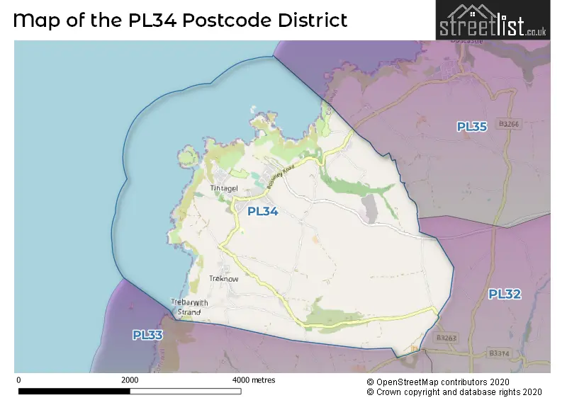
The postcode area has a boundary with Celtic Sea.
The PL34 Postcode shares a border with PL32 (CAMELFORD, Davidstow, Advent) and PL35 (BOSCASTLE, St. Juliot, Minster).
In the PL34 postcode district, the primary settlement is Tintagel, located in the county of Cornwall in England. Other significant settlements in this district include Bossiney, Trebarwith Strand, Tregatta, Trenale, Trethevy, Treven, Trevillick, and Trewarmett. The most significant post town in this district is Tintagel.
For the district PL34, we have data on 1 postcode sectors. Here's a breakdown: The sector PL34 0, covers Tintagel in Cornwall.
PL34 Postcode Sectors


Map of the PL34 Postcode District
Explore the PL34 postcode district by using our free interactive map.
When it comes to local government, postal geography often disregards political borders. However, for a breakdown in the PL34 District: the district mostly encompasses the Cornwall area with a total of 80 postcodes.
Recent House Sales in PL34
| Date | Price | Address |
|---|---|---|
| 22/09/2023 | £350,000 | Trerammet Crescent, Tintagel, PL34 0BN |
| 08/09/2023 | £400,000 | Bossiney Road, Tintagel, PL34 0AB |
| 25/08/2023 | £325,000 | Rock Cottages, Treknow, Tintagel, PL34 0EN |
| 18/08/2023 | £145,775 | Molesworth Street, Tintagel, PL34 0BZ |
| 17/08/2023 | £785,000 | Trethevy, Tintagel, PL34 0BG |
| 04/08/2023 | £200,000 | Bossiney, Tintagel, PL34 0AY |
| 03/07/2023 | £107,500 | Bossiney Road, Tintagel, PL34 0AJ |
| 28/06/2023 | £230,000 | Westground Way, Tintagel, PL34 0BH |
| 23/06/2023 | £405,000 | Tintagel, PL34 0HH |
| 16/06/2023 | £222,500 | The Butts, Tintagel, PL34 0AT |
Weather Forecast for PL34
Press Button to Show Forecast for Tintagel Youth Hostel
| Time Period | Icon | Description | Temperature | Rain Probability | Wind |
|---|---|---|---|---|---|
| 06:00 to 09:00 | Sunny day | 9.0°C (feels like 6.0°C) | 0.00% | NNE 11 mph | |
| 09:00 to 12:00 | Cloudy | 10.0°C (feels like 8.0°C) | 4.00% | N 9 mph | |
| 12:00 to 15:00 | Cloudy | 10.0°C (feels like 8.0°C) | 3.00% | NNW 9 mph | |
| 15:00 to 18:00 | Partly cloudy (day) | 10.0°C (feels like 8.0°C) | 0.00% | NNW 9 mph | |
| 18:00 to 21:00 | Partly cloudy (day) | 10.0°C (feels like 7.0°C) | 0.00% | NNW 11 mph | |
| 21:00 to 00:00 | Clear night | 9.0°C (feels like 7.0°C) | 0.00% | NNW 11 mph |
Press Button to Show Forecast for Tintagel Youth Hostel
| Time Period | Icon | Description | Temperature | Rain Probability | Wind |
|---|---|---|---|---|---|
| 00:00 to 03:00 | Clear night | 9.0°C (feels like 6.0°C) | 0.00% | NNW 9 mph | |
| 03:00 to 06:00 | Clear night | 9.0°C (feels like 7.0°C) | 1.00% | NW 7 mph | |
| 06:00 to 09:00 | Partly cloudy (day) | 9.0°C (feels like 7.0°C) | 1.00% | W 7 mph | |
| 09:00 to 12:00 | Partly cloudy (day) | 10.0°C (feels like 8.0°C) | 2.00% | WNW 11 mph | |
| 12:00 to 15:00 | Partly cloudy (day) | 11.0°C (feels like 8.0°C) | 3.00% | NW 11 mph | |
| 15:00 to 18:00 | Partly cloudy (day) | 10.0°C (feels like 7.0°C) | 3.00% | NW 11 mph | |
| 18:00 to 21:00 | Partly cloudy (day) | 9.0°C (feels like 7.0°C) | 2.00% | WNW 11 mph | |
| 21:00 to 00:00 | Cloudy | 9.0°C (feels like 7.0°C) | 8.00% | NW 9 mph |
Press Button to Show Forecast for Tintagel Youth Hostel
| Time Period | Icon | Description | Temperature | Rain Probability | Wind |
|---|---|---|---|---|---|
| 00:00 to 03:00 | Cloudy | 8.0°C (feels like 6.0°C) | 12.00% | WSW 7 mph | |
| 03:00 to 06:00 | Cloudy | 8.0°C (feels like 6.0°C) | 13.00% | WSW 9 mph | |
| 06:00 to 09:00 | Overcast | 8.0°C (feels like 5.0°C) | 16.00% | S 9 mph | |
| 09:00 to 12:00 | Cloudy | 10.0°C (feels like 7.0°C) | 14.00% | SSW 11 mph | |
| 12:00 to 15:00 | Cloudy | 10.0°C (feels like 8.0°C) | 12.00% | W 11 mph | |
| 15:00 to 18:00 | Cloudy | 11.0°C (feels like 8.0°C) | 16.00% | SW 11 mph | |
| 18:00 to 21:00 | Cloudy | 10.0°C (feels like 8.0°C) | 13.00% | SW 9 mph | |
| 21:00 to 00:00 | Cloudy | 9.0°C (feels like 6.0°C) | 9.00% | SE 9 mph |
Press Button to Show Forecast for Tintagel Youth Hostel
| Time Period | Icon | Description | Temperature | Rain Probability | Wind |
|---|---|---|---|---|---|
| 00:00 to 03:00 | Cloudy | 8.0°C (feels like 6.0°C) | 10.00% | ESE 9 mph | |
| 03:00 to 06:00 | Cloudy | 8.0°C (feels like 5.0°C) | 12.00% | ESE 9 mph | |
| 06:00 to 09:00 | Cloudy | 8.0°C (feels like 6.0°C) | 8.00% | SSE 9 mph | |
| 09:00 to 12:00 | Cloudy | 10.0°C (feels like 8.0°C) | 9.00% | NE 11 mph | |
| 12:00 to 15:00 | Overcast | 11.0°C (feels like 9.0°C) | 15.00% | N 13 mph | |
| 15:00 to 18:00 | Heavy rain | 11.0°C (feels like 8.0°C) | 75.00% | NE 13 mph | |
| 18:00 to 21:00 | Light rain | 10.0°C (feels like 8.0°C) | 60.00% | NE 13 mph | |
| 21:00 to 00:00 | Light rain | 10.0°C (feels like 7.0°C) | 55.00% | NW 11 mph |
Where is the PL34 Postcode District?
The PL34 postcode district is located in Tintagel, a town in Cornwall. Tintagel is situated near several other towns, including Delabole to the south, Boscastle to the northeast, Camelford to the southeast, Port Isaac to the southwest, and Launceston to the east. Additionally, the distance from Tintagel to London is approximately 208.79 miles.
The district is within the post town of TINTAGEL.
The sector has postcodes within the nation of England.
The PL34 Postcode District is in the Cornwall and Isles of Scilly region of Cornwall and Isles of Scilly within the South West (England).
Postcode Sectors within the PL34 District
| Postcode Sector | Delivery Office |
|---|---|
| PL34 0 | Tintagel Scale Payment Delivery Office |
| P | L | 3 | 4 | - | X | X | X |
| P | L | 3 | 4 | Space | Numeric | Letter | Letter |
Tourist Attractions within the Postcode Area
We found 2 visitor attractions within the PL34 postcode area
| Tintagel Castle |
|---|
| Historic Properties |
| Castle / Fort |
| View Tintagel Castle on Google Maps |
| Tintagel Old Post Office |
| Historic Properties |
| Historic House / House and Garden / Palace |
| View Tintagel Old Post Office on Google Maps |
Current Monthly Rental Prices
| # Bedrooms | Min Price | Max Price | Avg Price |
|---|---|---|---|
| £42 | £42 | £42 |
Current House Prices
| # Bedrooms | Min Price | Max Price | Avg Price |
|---|---|---|---|
| £270,000 | £270,000 | £270,000 | |
| 2 | £137,000 | £480,000 | £304,429 |
| 3 | £225,000 | £525,000 | £370,000 |
| 4 | £350,000 | £1,000,000 | £550,495 |
| 5 | £600,000 | £690,000 | £645,000 |
| 6 | £690,000 | £690,000 | £690,000 |
| 8 | £750,000 | £750,000 | £750,000 |
Estate Agents who Operate in the PL34 District
| Logo | Name | Brand Name | Address | Contact Number | Total Properties |
|---|---|---|---|---|---|
 | Wadebridge | Bond Oxborough Phillips | 7 Molesworth Street, Wadebridge, PL27 7DA | 01208 228686 | 7 |
 | Camelford | Cole Rayment & White | 27B Market Place, Camelford, PL32 9PD | 01840 701944 | 4 |
 | Wadebridge | Miller Countrywide | 30 Molesworth Street, Wadebridge, Cornwall, PL27 7DP | 01208 223242 | 3 |
 | Camelford | Kernow Properties | 20 Market Place, Camelford, PL32 9PD | 01840 700544 | 3 |
 | Launceston | Stags | Kensey House, 18 Western Road, Launceston, PL15 7AS | 01566 708728 | 2 |
| Type of Property | 2018 Average | 2018 Sales | 2017 Average | 2017 Sales | 2016 Average | 2016 Sales | 2015 Average | 2015 Sales |
|---|---|---|---|---|---|---|---|---|
| Detached | £304,467 | 15 | £318,800 | 25 | £295,346 | 26 | £296,180 | 25 |
| Semi-Detached | £279,188 | 8 | £293,250 | 8 | £237,643 | 7 | £226,983 | 6 |
| Terraced | £176,200 | 5 | £173,917 | 6 | £227,456 | 9 | £131,000 | 3 |
| Flats | £258,500 | 4 | £142,000 | 1 | £0 | 0 | £94,000 | 1 |