The PL5 1 postcode sector is within the county of Devon.
Did you know? According to the 2021 Census, the PL5 1 postcode sector is home to a bustling 12,135 residents!
Given that each sector allows for 400 unique postcode combinations. Letters C, I, K, M, O and V are not allowed in the last two letters of a postcode. With 242 postcodes already in use, this leaves 158 units available.
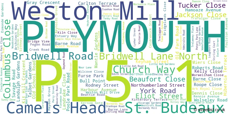
The largest settlement in the PL5 1 postal code is PLYMOUTH followed by Weston Mill, and St. Budeaux.
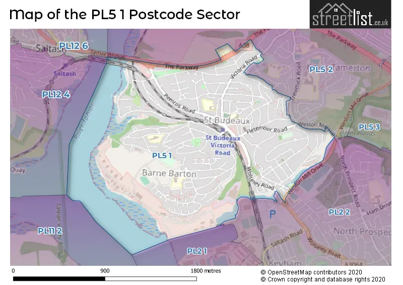
The PL5 1 Postcode shares a border with PL5 2 (PLYMOUTH, Higher St. Budeaux) and PL2 2 (PLYMOUTH, Keyham, North Prospect).
The sector is within the post town of PLYMOUTH.
PL5 1 is a postcode sector within the PL5 postcode district which is within the PL Plymouth postcode area.
The Royal Mail delivery office for the PL5 1 postal sector is the West Park Delivery Office.
The area of the PL5 1 postcode sector is 1.04 square miles which is 2.70 square kilometres or 667.81 square acres.
The PL5 1 postcode sector is crossed by the A38 Major A road.

Map of the PL5 1 Postcode Sector
Explore the PL5 1 postcode sector by using our free interactive map.
| P | L | 5 | - | 1 | X | X |
| P | L | 5 | Space | 1 | Letter | Letter |
Official List of Streets
PLYMOUTH (110 Streets)
Weston Mill (2 Streets)
St. Budeaux (3 Streets)
Camels Head (1 Streets)
Unofficial Streets or Alternative Spellings
Weather Forecast for PL5 1
Press Button to Show Forecast for Barne Barton
| Time Period | Icon | Description | Temperature | Rain Probability | Wind |
|---|---|---|---|---|---|
| 12:00 to 15:00 | Cloudy | 10.0°C (feels like 7.0°C) | 5.00% | NNW 16 mph | |
| 15:00 to 18:00 | Overcast | 10.0°C (feels like 6.0°C) | 8.00% | NW 16 mph | |
| 18:00 to 21:00 | Overcast | 9.0°C (feels like 6.0°C) | 17.00% | NW 11 mph | |
| 21:00 to 00:00 | Cloudy | 8.0°C (feels like 6.0°C) | 42.00% | N 7 mph |
Press Button to Show Forecast for Barne Barton
| Time Period | Icon | Description | Temperature | Rain Probability | Wind |
|---|---|---|---|---|---|
| 00:00 to 03:00 | Clear night | 7.0°C (feels like 5.0°C) | 3.00% | N 7 mph | |
| 03:00 to 06:00 | Clear night | 5.0°C (feels like 3.0°C) | 0.00% | N 7 mph | |
| 06:00 to 09:00 | Sunny day | 4.0°C (feels like 2.0°C) | 0.00% | N 7 mph | |
| 09:00 to 12:00 | Sunny day | 8.0°C (feels like 7.0°C) | 0.00% | NNE 4 mph | |
| 12:00 to 15:00 | Sunny day | 11.0°C (feels like 10.0°C) | 0.00% | WSW 7 mph | |
| 15:00 to 18:00 | Partly cloudy (day) | 11.0°C (feels like 9.0°C) | 1.00% | SW 11 mph | |
| 18:00 to 21:00 | Partly cloudy (day) | 11.0°C (feels like 9.0°C) | 0.00% | WNW 11 mph | |
| 21:00 to 00:00 | Partly cloudy (night) | 9.0°C (feels like 7.0°C) | 1.00% | W 9 mph |
Press Button to Show Forecast for Barne Barton
| Time Period | Icon | Description | Temperature | Rain Probability | Wind |
|---|---|---|---|---|---|
| 00:00 to 03:00 | Cloudy | 9.0°C (feels like 7.0°C) | 5.00% | W 11 mph | |
| 03:00 to 06:00 | Cloudy | 10.0°C (feels like 7.0°C) | 5.00% | WNW 11 mph | |
| 06:00 to 09:00 | Cloudy | 10.0°C (feels like 7.0°C) | 8.00% | NW 11 mph | |
| 09:00 to 12:00 | Cloudy | 11.0°C (feels like 8.0°C) | 5.00% | NW 16 mph | |
| 12:00 to 15:00 | Cloudy | 12.0°C (feels like 9.0°C) | 4.00% | NNW 16 mph | |
| 15:00 to 18:00 | Partly cloudy (day) | 13.0°C (feels like 9.0°C) | 2.00% | NNW 18 mph | |
| 18:00 to 21:00 | Sunny day | 11.0°C (feels like 8.0°C) | 1.00% | NNW 16 mph | |
| 21:00 to 00:00 | Clear night | 9.0°C (feels like 6.0°C) | 1.00% | NNW 11 mph |
Press Button to Show Forecast for Barne Barton
| Time Period | Icon | Description | Temperature | Rain Probability | Wind |
|---|---|---|---|---|---|
| 00:00 to 03:00 | Clear night | 7.0°C (feels like 5.0°C) | 1.00% | N 9 mph | |
| 03:00 to 06:00 | Clear night | 6.0°C (feels like 3.0°C) | 1.00% | N 9 mph | |
| 06:00 to 09:00 | Sunny day | 6.0°C (feels like 4.0°C) | 0.00% | N 7 mph | |
| 09:00 to 12:00 | Sunny day | 10.0°C (feels like 9.0°C) | 1.00% | NE 7 mph | |
| 12:00 to 15:00 | Cloudy | 12.0°C (feels like 11.0°C) | 5.00% | ENE 7 mph | |
| 15:00 to 18:00 | Partly cloudy (day) | 13.0°C (feels like 12.0°C) | 2.00% | SE 7 mph | |
| 18:00 to 21:00 | Partly cloudy (day) | 11.0°C (feels like 10.0°C) | 2.00% | SSE 7 mph | |
| 21:00 to 00:00 | Clear night | 8.0°C (feels like 7.0°C) | 1.00% | SSE 4 mph |
Press Button to Show Forecast for Barne Barton
| Time Period | Icon | Description | Temperature | Rain Probability | Wind |
|---|---|---|---|---|---|
| 00:00 to 03:00 | Clear night | 6.0°C (feels like 5.0°C) | 1.00% | NNE 4 mph | |
| 03:00 to 06:00 | Clear night | 5.0°C (feels like 4.0°C) | 1.00% | NE 4 mph | |
| 06:00 to 09:00 | Sunny day | 6.0°C (feels like 5.0°C) | 1.00% | NNE 4 mph | |
| 09:00 to 12:00 | Sunny day | 11.0°C (feels like 10.0°C) | 0.00% | NE 7 mph | |
| 12:00 to 15:00 | Partly cloudy (day) | 13.0°C (feels like 11.0°C) | 1.00% | ENE 7 mph | |
| 15:00 to 18:00 | Cloudy | 13.0°C (feels like 11.0°C) | 5.00% | E 9 mph | |
| 18:00 to 21:00 | Partly cloudy (day) | 12.0°C (feels like 11.0°C) | 3.00% | NNE 7 mph | |
| 21:00 to 00:00 | Clear night | 9.0°C (feels like 7.0°C) | 1.00% | NE 7 mph |
Schools and Places of Education Within the PL5 1 Postcode Sector
Riverside Community Primary School
Foundation school
210 Poole Park Road, Plymouth, Devon, PL5 1DD
Head: Mrs Clare Willcocks
Ofsted Rating: Good
Inspection: 2023-05-11 (342 days ago)
Website: Visit Riverside Community Primary School Website
Phone: 01752365297
Number of Pupils: 497
St Paul's Roman Catholic Primary School
Academy sponsor led
Pemros Road, Plymouth, Devon, PL5 1NE
Head: Mrs Joanne Hensman
Ofsted Rating: Good
Inspection: 2022-07-06 (651 days ago)
Website: Visit St Paul's Roman Catholic Primary School Website
Phone: 01752365459
Number of Pupils: 153
Victoria Road Primary
Academy converter
Trelawney Avenue, Plymouth, Devon, PL5 1RH
Head: Mrs Maria Anderson
Ofsted Rating: Good
Inspection: 2023-01-12 (461 days ago)
Website: Visit Victoria Road Primary Website
Phone: 01752365411
Number of Pupils: 204
House Prices in the PL5 1 Postcode Sector
| Type of Property | 2018 Average | 2018 Sales | 2017 Average | 2017 Sales | 2016 Average | 2016 Sales | 2015 Average | 2015 Sales |
|---|---|---|---|---|---|---|---|---|
| Detached | £200,500 | 4 | £279,244 | 8 | £210,640 | 10 | £280,714 | 7 |
| Semi-Detached | £156,921 | 82 | £145,975 | 69 | £150,031 | 89 | £145,178 | 83 |
| Terraced | £132,688 | 66 | £133,911 | 56 | £129,325 | 66 | £127,441 | 68 |
| Flats | £85,240 | 25 | £78,659 | 22 | £80,350 | 20 | £76,838 | 30 |
Important Postcodes PL5 1 in the Postcode Sector
PL5 1BH is the postcode for Camels Head Technology Centre, Harbour Avenue
PL5 1DD is the postcode for Riverside Community Primary School Extension, 210 Poole Park Road, and Riverside Community Primary School, 210 Poole Park Road
PL5 1LP is the postcode for Tamar Bridge & Torpoint Ferry Joint Committee, Tamar Bridge Office, Pemros Road
PL5 1NE is the postcode for St. Pauls RC Primary School, Pemros Road
PL5 1RH is the postcode for Victoria Road Primary School, Trelawney Avenue
PL5 1RQ is the postcode for Plymouth City Council, St. Budeaux Library, Victoria Road
| The PL5 1 Sector is within these Local Authorities |
|
|---|---|
| The PL5 1 Sector is within these Counties |
|
| The PL5 1 Sector is within these Water Company Areas |
|