The PO2 9 postcode sector is within the county of Hampshire.
Did you know? According to the 2021 Census, the PO2 9 postcode sector is home to a bustling 8,738 residents!
Given that each sector allows for 400 unique postcode combinations. Letters C, I, K, M, O and V are not allowed in the last two letters of a postcode. With 165 postcodes already in use, this leaves 235 units available.
The PO2 9 postal code covers the settlement of PORTSMOUTH.
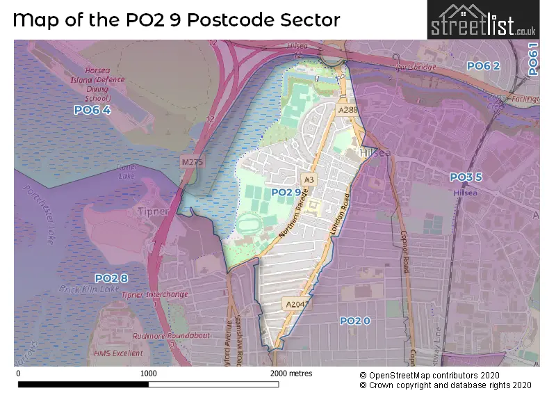
The PO2 9 Postcode shares a border with PO2 0 (PORTSMOUTH), PO6 3 (PORTSMOUTH, Cosham), PO2 8 (PORTSMOUTH), PO3 5 (PORTSMOUTH, Hilsea) and PO6 4 (PORTSMOUTH, Port Solent, Cosham).
The sector is within the post town of PORTSMOUTH.
PO2 9 is a postcode sector within the PO2 postcode district which is within the PO Portsmouth postcode area.
The Royal Mail delivery office for the PO2 9 postal sector is the Portsmouth Delivery Office.
The area of the PO2 9 postcode sector is 0.72 square miles which is 1.87 square kilometres or 461.91 square acres.

Map of the PO2 9 Postcode Sector
Explore the PO2 9 postcode sector by using our free interactive map.
| P | O | 2 | - | 9 | X | X |
| P | O | 2 | Space | 9 | Letter | Letter |
Official List of Streets
PORTSMOUTH (57 Streets)
Unofficial Streets or Alternative Spellings
PORTSMOUTH
AMBERLEY ROAD ANGERSTEIN ROAD ARRAS ROAD BATTENBURG AVENUE COPNOR ROAD CURTIS MEAD GATCOMBE DRIVE HEWETT ROAD INHURST ROAD MAYFIELD ROAD MERRIVALE ROAD MONTAGUE ROAD RAMPART GARDENS RANDOLPH ROAD THURBERN ROAD TORRINGTON ROADHilsea
MILITARY ROAD FALKLANDS ROAD HORSEA LANE LOWER WADE WAY (TIDAL) ST CHADS AVENUE ST FRANCIS COURT WYLLIE ROADWeather Forecast for PO2 9
Press Button to Show Forecast for Hilsea
| Time Period | Icon | Description | Temperature | Rain Probability | Wind |
|---|---|---|---|---|---|
| 12:00 to 15:00 | Overcast | 12.0°C (feels like 10.0°C) | 14.00% | W 9 mph | |
| 15:00 to 18:00 | Light rain | 11.0°C (feels like 8.0°C) | 50.00% | W 11 mph | |
| 18:00 to 21:00 | Light rain | 10.0°C (feels like 8.0°C) | 48.00% | WSW 9 mph | |
| 21:00 to 00:00 | Overcast | 9.0°C (feels like 8.0°C) | 12.00% | NNW 7 mph |
Press Button to Show Forecast for Hilsea
| Time Period | Icon | Description | Temperature | Rain Probability | Wind |
|---|---|---|---|---|---|
| 00:00 to 03:00 | Cloudy | 8.0°C (feels like 6.0°C) | 5.00% | NNE 7 mph | |
| 03:00 to 06:00 | Cloudy | 7.0°C (feels like 4.0°C) | 6.00% | NE 9 mph | |
| 06:00 to 09:00 | Cloudy | 7.0°C (feels like 4.0°C) | 9.00% | ENE 11 mph | |
| 09:00 to 12:00 | Overcast | 8.0°C (feels like 5.0°C) | 12.00% | ENE 11 mph | |
| 12:00 to 15:00 | Cloudy | 10.0°C (feels like 7.0°C) | 14.00% | E 9 mph | |
| 15:00 to 18:00 | Cloudy | 10.0°C (feels like 8.0°C) | 14.00% | ESE 9 mph | |
| 18:00 to 21:00 | Cloudy | 10.0°C (feels like 8.0°C) | 12.00% | ESE 9 mph | |
| 21:00 to 00:00 | Cloudy | 8.0°C (feels like 6.0°C) | 12.00% | ESE 9 mph |
Press Button to Show Forecast for Hilsea
| Time Period | Icon | Description | Temperature | Rain Probability | Wind |
|---|---|---|---|---|---|
| 00:00 to 03:00 | Overcast | 8.0°C (feels like 6.0°C) | 22.00% | ENE 11 mph | |
| 03:00 to 06:00 | Light rain | 7.0°C (feels like 4.0°C) | 50.00% | ENE 11 mph | |
| 06:00 to 09:00 | Cloudy | 8.0°C (feels like 5.0°C) | 18.00% | ENE 11 mph | |
| 09:00 to 12:00 | Cloudy | 10.0°C (feels like 7.0°C) | 14.00% | E 13 mph | |
| 12:00 to 15:00 | Cloudy | 12.0°C (feels like 9.0°C) | 19.00% | E 13 mph | |
| 15:00 to 18:00 | Cloudy | 12.0°C (feels like 9.0°C) | 17.00% | E 11 mph | |
| 18:00 to 21:00 | Light rain | 11.0°C (feels like 8.0°C) | 53.00% | ENE 16 mph | |
| 21:00 to 00:00 | Light rain | 10.0°C (feels like 7.0°C) | 49.00% | ENE 16 mph |
Press Button to Show Forecast for Hilsea
| Time Period | Icon | Description | Temperature | Rain Probability | Wind |
|---|---|---|---|---|---|
| 00:00 to 03:00 | Heavy rain | 10.0°C (feels like 7.0°C) | 75.00% | ENE 16 mph | |
| 03:00 to 06:00 | Light rain shower (night) | 10.0°C (feels like 7.0°C) | 45.00% | E 11 mph | |
| 06:00 to 09:00 | Light rain shower (day) | 10.0°C (feels like 7.0°C) | 38.00% | ESE 11 mph | |
| 09:00 to 12:00 | Light rain shower (day) | 11.0°C (feels like 9.0°C) | 42.00% | S 11 mph | |
| 12:00 to 15:00 | Light rain shower (day) | 12.0°C (feels like 10.0°C) | 38.00% | SSW 11 mph | |
| 15:00 to 18:00 | Light rain shower (day) | 12.0°C (feels like 9.0°C) | 38.00% | WSW 16 mph | |
| 18:00 to 21:00 | Cloudy | 11.0°C (feels like 9.0°C) | 14.00% | WSW 13 mph | |
| 21:00 to 00:00 | Clear night | 10.0°C (feels like 8.0°C) | 7.00% | WSW 9 mph |
Schools and Places of Education Within the PO2 9 Postcode Sector
King's Academy Northern Parade (Infant)
Academy converter
Kipling Road, Portsmouth, Hampshire, PO2 9NJ
Head: Mrs Kathryn Wilden
Ofsted Rating: Requires improvement
Inspection: 2022-04-06 (750 days ago)
Website: Visit King's Academy Northern Parade (Infant) Website
Phone: 02392662596
Number of Pupils: 262
King's Academy Northern Parade (Junior)
Academy converter
Doyle Avenue, Portsmouth, Hampshire, PO2 9NE
Head: Mrs Kathryn Wilden
Ofsted Rating: Good
Inspection: 2023-10-18 (190 days ago)
Website: Visit King's Academy Northern Parade (Junior) Website
Phone: 02392662129
Number of Pupils: 441
Trafalgar School
Academy sponsor led
London Road, Portsmouth, Hampshire, PO2 9RJ
Head: Mrs Claire Copeland
Ofsted Rating: Good
Inspection: 2023-06-07 (323 days ago)
Website: Visit Trafalgar School Website
Phone: 02392693521
Number of Pupils: 971
UTC Portsmouth
University technical college
London Road, Portsmouth, Hampshire, PO2 9DU
Head: Mr James Doherty
Ofsted Rating: Outstanding
Inspection: 2021-06-30 (1030 days ago)
Website: Visit UTC Portsmouth Website
Phone: 02393120200
Number of Pupils: 456
House Prices in the PO2 9 Postcode Sector
| Type of Property | 2018 Average | 2018 Sales | 2017 Average | 2017 Sales | 2016 Average | 2016 Sales | 2015 Average | 2015 Sales |
|---|---|---|---|---|---|---|---|---|
| Detached | £289,950 | 1 | £400,000 | 2 | £307,000 | 4 | £219,000 | 4 |
| Semi-Detached | £238,889 | 9 | £256,000 | 7 | £231,178 | 17 | £200,063 | 8 |
| Terraced | £239,031 | 74 | £234,954 | 84 | £212,331 | 69 | £202,791 | 84 |
| Flats | £137,841 | 39 | £132,804 | 43 | £126,286 | 59 | £122,229 | 44 |
Important Postcodes PO2 9 in the Postcode Sector
PO2 9AD is the postcode for Indoor Tennis Centre, Alex Way, and Portsmouth Gymnastics Centre, Alex Way
PO2 9AX is the postcode for HALL, Corpus Christi RC Primary School, Gladys Avenue, Corpus Christi RC Primary School, Gladys Avenue, KEYSTAGE 2, Corpus Christi RC Primary School, Gladys Avenue, and Portsmouth City Council, North End Library, 7 Gladys Avenue
PO2 9DU is the postcode for UTC PORTSMOUTH, LONDON ROAD, HILSEA
PO2 9NA is the postcode for Victory Re-Ablement Unit, Wylie Road
PO2 9NE is the postcode for Northern Parade Junior School, Doyle Avenue
PO2 9NJ is the postcode for Northern Parade Infant School, Kipling Road
PO2 9QA is the postcode for The Mountbatten Centre, Twyford Avenue, Alexandra Park, Mountbatten Centre, Twyford Avenue, and DRY & WET CENTRES, The Mountbatten Centre, Twyford Avenue, Alexandra Park
PO2 9RJ is the postcode for Trafalgar School, London Road, and TRAFALGAR SCHOOL, LONDON ROAD, HILSEA
| The PO2 9 Sector is within these Local Authorities |
|
|---|---|
| The PO2 9 Sector is within these Counties |
|
| The PO2 9 Sector is within these Water Company Areas |
|