The PO21 postcode district is a postal district located in the PO Portsmouth postcode area with a population of 43,414 residents according to the 2021 England and Wales Census.
The area of the PO21 postcode district is 6.56 square miles which is 16.99 square kilometres or 4,198.55 acres.
Currently, the PO21 district has about 1336 postcode units spread across 5 geographic postcode sectors.
Given that each sector allows for 400 unique postcode combinations, the district has a capacity of 2,000 postcodes. With 1336 postcodes already in use, this leaves 664 units available.
The PO21 postal code covers the settlement of BOGNOR REGIS.
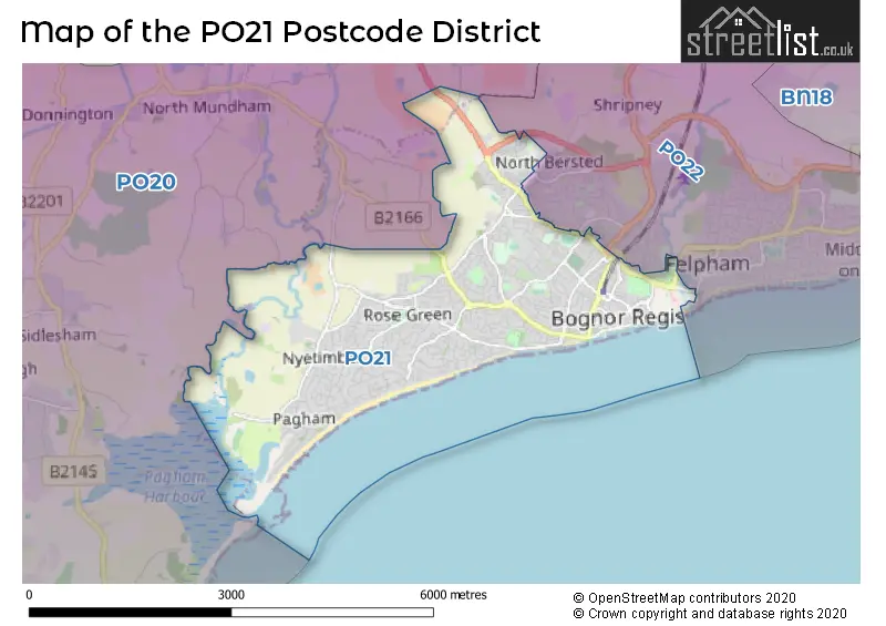
The postcode area has a boundary with The English Channel.
The PO21 Postcode shares a border with PO22 (BOGNOR REGIS, Barnham, Felpham) and PO20 (Selsey, West Wittering, Bracklesham Bay).
In the PO21 postcode district in West Sussex, the primary settlement is Bognor Regis. This is also the main post town in the area. Additionally, there are other significant settlements including Aldwick, Rose Green, and Pagham. There is also a smaller settlement called North Bersted.
For the district PO21, we have data on 6 postcode sectors. Here's a breakdown: The sector PO21 1, covers Bognor Regis in West Sussex. The sector PO21 2, covers Bognor Regis in West Sussex. The sector PO21 3, covers Bognor Regis in West Sussex. The sector PO21 4, covers Bognor Regis in West Sussex. The sector PO21 5, covers Bognor Regis in West Sussex. The sector PO21 9 is non-geographic. It's often designated for PO Boxes, large organisations, or special services.

Map of the PO21 Postcode District
Explore the PO21 postcode district by using our free interactive map.
When it comes to local government, postal geography often disregards political borders. However, for a breakdown in the PO21 District: the district mostly encompasses the Arun District area with a total of 1344 postcodes.
Recent House Sales in PO21
| Date | Price | Address |
|---|---|---|
| 26/10/2023 | £265,000 | Essex Road, Bognor Regis, PO21 2BU |
| 24/10/2023 | £725,000 | Colts Bay, Bognor Regis, PO21 4EH |
| 20/10/2023 | £630,000 | Willowhale Avenue, Bognor Regis, PO21 4BG |
| 03/10/2023 | £450,000 | Trinity Way, Bognor Regis, PO21 5RQ |
| 29/09/2023 | £395,000 | Rochester Way, Bognor Regis, PO21 3RD |
| 29/09/2023 | £378,000 | Boxgrove Gardens, Bognor Regis, PO21 4BB |
| 29/09/2023 | £200,000 | Rock Gardens, Bognor Regis, PO21 2LE |
| 29/09/2023 | £107,000 | Lennox Street, Bognor Regis, PO21 1XR |
| 29/09/2023 | £150,000 | Victoria Road, Bognor Regis, PO21 2LU |
| 28/09/2023 | £162,000 | Waverley Road, Bognor Regis, PO21 5NB |
Weather Forecast for PO21
Press Button to Show Forecast for Pagham (Beach)
| Time Period | Icon | Description | Temperature | Rain Probability | Wind |
|---|---|---|---|---|---|
| 09:00 to 12:00 | Sunny day | 10.0°C (feels like 8.0°C) | 1.00% | W 9 mph | |
| 12:00 to 15:00 | Cloudy | 12.0°C (feels like 9.0°C) | 8.00% | W 11 mph | |
| 15:00 to 18:00 | Overcast | 11.0°C (feels like 8.0°C) | 15.00% | W 11 mph | |
| 18:00 to 21:00 | Cloudy | 10.0°C (feels like 8.0°C) | 30.00% | WSW 9 mph | |
| 21:00 to 00:00 | Cloudy | 8.0°C (feels like 7.0°C) | 50.00% | NNW 4 mph |
Press Button to Show Forecast for Pagham (Beach)
| Time Period | Icon | Description | Temperature | Rain Probability | Wind |
|---|---|---|---|---|---|
| 00:00 to 03:00 | Cloudy | 7.0°C (feels like 5.0°C) | 6.00% | NE 7 mph | |
| 03:00 to 06:00 | Cloudy | 7.0°C (feels like 4.0°C) | 7.00% | NE 9 mph | |
| 06:00 to 09:00 | Cloudy | 7.0°C (feels like 3.0°C) | 8.00% | NE 11 mph | |
| 09:00 to 12:00 | Cloudy | 8.0°C (feels like 5.0°C) | 9.00% | ENE 11 mph | |
| 12:00 to 15:00 | Overcast | 10.0°C (feels like 8.0°C) | 18.00% | E 9 mph | |
| 15:00 to 18:00 | Overcast | 11.0°C (feels like 9.0°C) | 17.00% | ENE 9 mph | |
| 18:00 to 21:00 | Cloudy | 10.0°C (feels like 9.0°C) | 12.00% | ENE 9 mph | |
| 21:00 to 00:00 | Cloudy | 8.0°C (feels like 5.0°C) | 11.00% | E 9 mph |
Press Button to Show Forecast for Pagham (Beach)
| Time Period | Icon | Description | Temperature | Rain Probability | Wind |
|---|---|---|---|---|---|
| 00:00 to 03:00 | Overcast | 6.0°C (feels like 3.0°C) | 21.00% | ENE 9 mph | |
| 03:00 to 06:00 | Cloudy | 6.0°C (feels like 3.0°C) | 20.00% | ENE 9 mph | |
| 06:00 to 09:00 | Cloudy | 7.0°C (feels like 4.0°C) | 18.00% | ENE 11 mph | |
| 09:00 to 12:00 | Overcast | 10.0°C (feels like 8.0°C) | 18.00% | E 11 mph | |
| 12:00 to 15:00 | Overcast | 12.0°C (feels like 10.0°C) | 22.00% | E 11 mph | |
| 15:00 to 18:00 | Light rain shower (day) | 12.0°C (feels like 9.0°C) | 39.00% | E 13 mph | |
| 18:00 to 21:00 | Light rain | 11.0°C (feels like 8.0°C) | 51.00% | ENE 13 mph | |
| 21:00 to 00:00 | Light rain | 10.0°C (feels like 7.0°C) | 51.00% | NE 13 mph |
Press Button to Show Forecast for Pagham (Beach)
| Time Period | Icon | Description | Temperature | Rain Probability | Wind |
|---|---|---|---|---|---|
| 00:00 to 03:00 | Light rain | 10.0°C (feels like 7.0°C) | 53.00% | ENE 13 mph | |
| 03:00 to 06:00 | Heavy rain shower (night) | 10.0°C (feels like 7.0°C) | 59.00% | SE 11 mph | |
| 06:00 to 09:00 | Light rain | 10.0°C (feels like 8.0°C) | 50.00% | ESE 11 mph | |
| 09:00 to 12:00 | Light rain | 11.0°C (feels like 8.0°C) | 55.00% | SE 13 mph | |
| 12:00 to 15:00 | Light rain shower (day) | 13.0°C (feels like 10.0°C) | 39.00% | SSW 13 mph | |
| 15:00 to 18:00 | Light rain shower (day) | 13.0°C (feels like 10.0°C) | 39.00% | SW 13 mph | |
| 18:00 to 21:00 | Cloudy | 11.0°C (feels like 9.0°C) | 12.00% | WSW 13 mph | |
| 21:00 to 00:00 | Cloudy | 10.0°C (feels like 8.0°C) | 12.00% | WSW 9 mph |
Where is the PO21 Postcode District?
The postcode district PO21 is situated in the town of Bognor Regis. Bognor Regis is located in close proximity to several nearby towns. To the North West is Chichester, which is approximately 4.48 miles away. To the East is Littlehampton, located approximately 6.27 miles away. Arundel is situated to the North East, approximately 8.20 miles away. Hayling Island is located to the West, approximately 11.46 miles away. The town of Midhurst can be found to the North, approximately 14.67 miles away. Additionally, the centre of London is located 56.04 miles away from the PO21 postcode district.
The district is within the post town of BOGNOR REGIS.
The sector has postcodes within the nation of England.
The PO21 Postcode District is in the West Sussex (South West) region of Surrey, East and West Sussex within the South East (England).
| Postcode Sector | Delivery Office |
|---|---|
| PO21 1 | Bognor Regis Delivery Office |
| PO21 2 | Bognor Regis Delivery Office |
| PO21 3 | Bognor Regis Delivery Office |
| PO21 4 | Bognor Regis Delivery Office |
| PO21 5 | Bognor Regis Delivery Office |
| P | O | 2 | 1 | - | X | X | X |
| P | O | 2 | 1 | Space | Numeric | Letter | Letter |
Current Monthly Rental Prices
| # Bedrooms | Min Price | Max Price | Avg Price |
|---|---|---|---|
| £25 | £925 | £657 | |
| 1 | £700 | £900 | £817 |
| 2 | £950 | £1,700 | £1,208 |
| 3 | £1,250 | £2,000 | £1,525 |
| 4 | £1,650 | £1,650 | £1,650 |
| 5 | £2,000 | £3,500 | £2,833 |
| 6 | £3,000 | £3,000 | £3,000 |
| 7 | £2,500 | £2,500 | £2,500 |
Current House Prices
| # Bedrooms | Min Price | Max Price | Avg Price |
|---|---|---|---|
| £19,500 | £630,000 | £259,625 | |
| 1 | £65,500 | £295,000 | £135,313 |
| 2 | £29,950 | £750,000 | £271,503 |
| 3 | £129,000 | £1,500,000 | £430,591 |
| 4 | £197,500 | £1,500,000 | £598,578 |
| 5 | £425,000 | £2,250,000 | £1,183,611 |
| 6 | £375,000 | £3,350,000 | £1,008,333 |
| 7 | £450,000 | £450,000 | £450,000 |
| 9 | £580,000 | £580,000 | £580,000 |
| 16 | £1,750,000 | £1,750,000 | £1,750,000 |
Estate Agents who Operate in the PO21 District
| Logo | Name | Brand Name | Address | Contact Number | Total Properties |
|---|---|---|---|---|---|
 | Bognor Regis | Henry Adams | 25 High Street, Bognor Regis, PO21 1RS | 01243 973059 | 64 |
 | Bognor Regis | White & Brooks | 70 Aldwick Road, Bognor Regis, West Sussex, PO21 2PE | 020 3879 5247 | 55 |
 | Bognor Regis | Cubitt & West | 17b High Street, Bognor Regis, PO21 1RJ | 01243 973057 | 46 |
 | Bognor Regis | Coastguards Estate Agency | 6 Coastguards Parade, Barrack Lane, Bognor Regis, West Sussex, PO21 4DX | 020 3835 2530 | 34 |
 | Bognor Regis | Farndell Estate Agents | 47 Aldwick Road, Bognor Regis, PO21 2NJ | 01243 217446 | 29 |
| Type of Property | 2018 Average | 2018 Sales | 2017 Average | 2017 Sales | 2016 Average | 2016 Sales | 2015 Average | 2015 Sales |
|---|---|---|---|---|---|---|---|---|
| Detached | £416,451 | 250 | £407,243 | 247 | £397,626 | 239 | £371,704 | 263 |
| Semi-Detached | £288,043 | 155 | £274,704 | 196 | £263,016 | 164 | £241,588 | 198 |
| Terraced | £256,764 | 161 | £244,553 | 177 | £230,341 | 156 | £216,523 | 155 |
| Flats | £152,879 | 239 | £147,675 | 291 | £137,369 | 306 | £133,499 | 292 |