The PO8 postcode district is a postal district located in the PO Portsmouth postcode area with a population of 35,752 residents according to the 2021 England and Wales Census.
The area of the PO8 postcode district is 21.27 square miles which is 55.09 square kilometres or 13,613.31 acres.
Currently, the PO8 district has about 851 postcode units spread across 3 geographic postcode sectors.
Given that each sector allows for 400 unique postcode combinations, the district has a capacity of 1,200 postcodes. With 851 postcodes already in use, this leaves 349 units available.
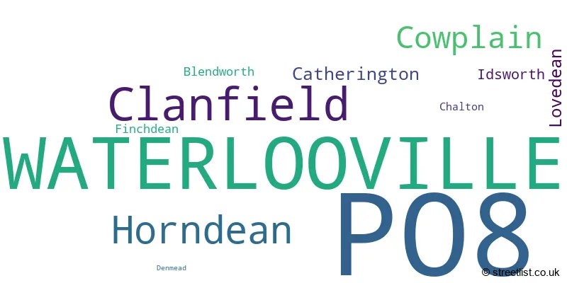
The largest settlement in the PO8 postal code is WATERLOOVILLE followed by Clanfield, and Horndean.
The PO8 Postcode shares a border with PO9 (HAVANT, ROWLAND'S CASTLE), GU31 (PETERSFIELD, Rogate, South Harting), GU32 (PETERSFIELD, East Meon, West Meon) and PO7 (WATERLOOVILLE, Denmead, Hambledon).
The primary settlement in the PO8 postcode district is Waterlooville in the county of Hampshire, England. Other significant settlements in the district include Blendworth, Catherington, Chalton, Clanfield, Denmead, Finchdean, Horndean, Idsworth, and Lovedean. The most significant post town in the district is also Waterlooville.
For the district PO8, we have data on 3 postcode sectors. Here's a breakdown: The sector PO8 0, covers Clanfield and Waterlooville and Horndean in Hampshire. The sector PO8 8, covers Waterlooville and Cowplain in Hampshire. The sector PO8 9, covers Waterlooville in Hampshire.

Map of the PO8 Postcode District
Explore the PO8 postcode district by using our free interactive map.
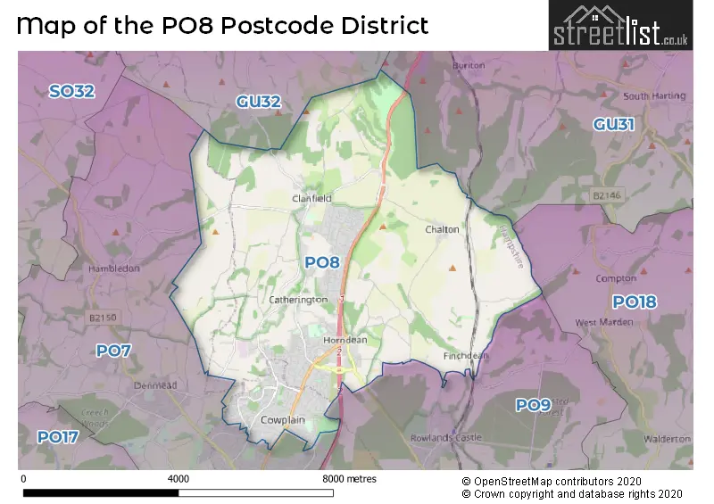
When it comes to local government, postal geography often disregards political borders. However, for a breakdown in the PO8 District: the district mostly encompasses the East Hampshire District (518 postcodes), followed by the Havant District (B) area (338 postcodes), and finally, the Winchester District (B) area (6 postcodes).
Recent House Sales in PO8
| Date | Price | Address |
|---|---|---|
| 23/10/2023 | £345,000 | Milton Road, Cowplain, Waterlooville, PO8 8LS |
| 20/10/2023 | £122,500 | Holman Close, Cowplain, Waterlooville, PO8 8HD |
| 12/10/2023 | £495,000 | Havant Road, Horndean, Waterlooville, PO8 0DB |
| 10/10/2023 | £510,000 | Cotwell Avenue, Cowplain, Waterlooville, PO8 9AP |
| 10/10/2023 | £340,000 | Greenfield Crescent, Cowplain, Waterlooville, PO8 9EJ |
| 04/10/2023 | £375,000 | Linda Grove, Waterlooville, PO8 8UY |
| 04/10/2023 | £500,000 | Nightjar Close, Waterlooville, PO8 9YU |
| 29/09/2023 | £325,000 | Woodstock Avenue, Horndean, Waterlooville, PO8 9TF |
| 25/09/2023 | £530,000 | Hart Plain Avenue, Waterlooville, PO8 8RX |
| 25/09/2023 | £426,400 | Elaine Gardens, Waterlooville, PO8 9QS |
Weather Forecast for PO8
Press Button to Show Forecast for Horndean
| Time Period | Icon | Description | Temperature | Rain Probability | Wind |
|---|---|---|---|---|---|
| 15:00 to 18:00 | Light rain | 9.0°C (feels like 7.0°C) | 50.00% | WSW 9 mph | |
| 18:00 to 21:00 | Cloudy | 9.0°C (feels like 7.0°C) | 52.00% | W 7 mph | |
| 21:00 to 00:00 | Cloudy | 7.0°C (feels like 5.0°C) | 6.00% | N 4 mph |
Press Button to Show Forecast for Horndean
| Time Period | Icon | Description | Temperature | Rain Probability | Wind |
|---|---|---|---|---|---|
| 00:00 to 03:00 | Cloudy | 6.0°C (feels like 4.0°C) | 9.00% | NE 7 mph | |
| 03:00 to 06:00 | Cloudy | 5.0°C (feels like 3.0°C) | 7.00% | NE 9 mph | |
| 06:00 to 09:00 | Cloudy | 5.0°C (feels like 2.0°C) | 9.00% | ENE 9 mph | |
| 09:00 to 12:00 | Overcast | 7.0°C (feels like 4.0°C) | 12.00% | ENE 11 mph | |
| 12:00 to 15:00 | Cloudy | 9.0°C (feels like 7.0°C) | 16.00% | E 9 mph | |
| 15:00 to 18:00 | Overcast | 10.0°C (feels like 8.0°C) | 17.00% | ENE 7 mph | |
| 18:00 to 21:00 | Cloudy | 9.0°C (feels like 8.0°C) | 13.00% | E 7 mph | |
| 21:00 to 00:00 | Cloudy | 7.0°C (feels like 5.0°C) | 12.00% | E 7 mph |
Press Button to Show Forecast for Horndean
| Time Period | Icon | Description | Temperature | Rain Probability | Wind |
|---|---|---|---|---|---|
| 00:00 to 03:00 | Cloudy | 5.0°C (feels like 3.0°C) | 18.00% | ENE 9 mph | |
| 03:00 to 06:00 | Light rain | 5.0°C (feels like 2.0°C) | 50.00% | ENE 9 mph | |
| 06:00 to 09:00 | Cloudy | 6.0°C (feels like 2.0°C) | 18.00% | ENE 11 mph | |
| 09:00 to 12:00 | Overcast | 9.0°C (feels like 6.0°C) | 17.00% | ENE 11 mph | |
| 12:00 to 15:00 | Light rain | 11.0°C (feels like 9.0°C) | 46.00% | E 11 mph | |
| 15:00 to 18:00 | Light rain | 11.0°C (feels like 9.0°C) | 49.00% | ENE 11 mph | |
| 18:00 to 21:00 | Light rain | 10.0°C (feels like 7.0°C) | 53.00% | ENE 11 mph | |
| 21:00 to 00:00 | Light rain | 9.0°C (feels like 6.0°C) | 49.00% | ENE 13 mph |
Press Button to Show Forecast for Horndean
| Time Period | Icon | Description | Temperature | Rain Probability | Wind |
|---|---|---|---|---|---|
| 00:00 to 03:00 | Heavy rain | 8.0°C (feels like 5.0°C) | 76.00% | ENE 11 mph | |
| 03:00 to 06:00 | Heavy rain | 8.0°C (feels like 5.0°C) | 75.00% | ENE 9 mph | |
| 06:00 to 09:00 | Light rain | 9.0°C (feels like 6.0°C) | 51.00% | SE 9 mph | |
| 09:00 to 12:00 | Light rain | 10.0°C (feels like 8.0°C) | 53.00% | SSE 9 mph | |
| 12:00 to 15:00 | Light rain shower (day) | 12.0°C (feels like 9.0°C) | 38.00% | SW 11 mph | |
| 15:00 to 18:00 | Light rain shower (day) | 12.0°C (feels like 9.0°C) | 36.00% | WSW 13 mph | |
| 18:00 to 21:00 | Light rain shower (day) | 10.0°C (feels like 8.0°C) | 32.00% | WSW 11 mph | |
| 21:00 to 00:00 | Partly cloudy (night) | 8.0°C (feels like 6.0°C) | 8.00% | WSW 7 mph |
Where is the PO8 Postcode District?
The data shows that the postcode district of PO8 is located in the town of Waterlooville. Waterlooville is situated in close proximity to several nearby towns, including Rowland's Castle, Havant, Petersfield, and Portsmouth. Waterlooville is approximately 54.88 miles away from the center of London.
The district is within the post town of WATERLOOVILLE.
The sector has postcodes within the nation of England.
The PO8 Postcode District is covers the following regions.
- Central Hampshire - Hampshire and Isle of Wight - South East (England)
- South Hampshire - Hampshire and Isle of Wight - South East (England)
| Postcode Sector | Delivery Office |
|---|---|
| PO8 0 | Waterlooville Delivery Office |
| PO8 8 | Waterlooville Delivery Office |
| PO8 9 | Waterlooville Delivery Office |
| P | O | 8 | - | X | X | X |
| P | O | 8 | Space | Numeric | Letter | Letter |
Current Monthly Rental Prices
| # Bedrooms | Min Price | Max Price | Avg Price |
|---|---|---|---|
| £795 | £795 | £795 | |
| 1 | £925 | £1,100 | £1,013 |
| 2 | £995 | £1,350 | £1,193 |
| 3 | £1,250 | £1,895 | £1,466 |
| 4 | £1,800 | £2,995 | £2,211 |
Current House Prices
| # Bedrooms | Min Price | Max Price | Avg Price |
|---|---|---|---|
| 1 | £125,000 | £200,000 | £153,842 |
| 2 | £76,250 | £510,000 | £275,947 |
| 3 | £180,000 | £659,995 | £387,259 |
| 4 | £275,000 | £1,600,000 | £520,485 |
| 5 | £396,000 | £1,950,000 | £741,914 |
| 6 | £850,000 | £850,000 | £850,000 |
Estate Agents who Operate in the PO8 District
| Logo | Name | Brand Name | Address | Contact Number | Total Properties |
|---|---|---|---|---|---|
 | Waterlooville | Archbold & Edwards | 224 London Road, Waterlooville, PO7 7HB | 0238 202 3795 | 25 |
 | Cowplain | Morris Dibben | 59 London Road Cowplain Waterlooville PO8 8UJ | 0238 001 5755 | 22 |
 | Clanfield | Pearsons | 41 Drift Road, Clanfield, Waterlooville, PO8 0JS | 0239 259 1717 | 21 |
 | Waterlooville | A J Eyre & Sons | 51, London Road, Waterlooville, PO7 7EX | 0238 254 4098 | 19 |
 | Waterlooville | Jeffries & Dibbens Estate and Lettings Agents | 226 London Road, Waterlooville, Hampshire, PO7 7HP | 0238 254 4445 | 18 |
| Type of Property | 2018 Average | 2018 Sales | 2017 Average | 2017 Sales | 2016 Average | 2016 Sales | 2015 Average | 2015 Sales |
|---|---|---|---|---|---|---|---|---|
| Detached | £399,617 | 248 | £390,428 | 276 | £371,076 | 319 | £352,794 | 374 |
| Semi-Detached | £295,248 | 166 | £296,917 | 165 | £278,395 | 181 | £254,244 | 205 |
| Terraced | £241,479 | 132 | £244,907 | 113 | £229,089 | 124 | £218,037 | 114 |
| Flats | £155,956 | 58 | £147,391 | 51 | £157,451 | 93 | £154,717 | 79 |