The PO9 6 postcode sector stands on the Hampshire and West Sussex border.
Did you know? According to the 2021 Census, the PO9 6 postcode sector is home to a bustling 3,171 residents!
Given that each sector allows for 400 unique postcode combinations. Letters C, I, K, M, O and V are not allowed in the last two letters of a postcode. With 83 postcodes already in use, this leaves 317 units available.
The largest settlement in the PO9 6 postal code is ROWLAND'S CASTLE followed by Forestside, and Stansted Park.
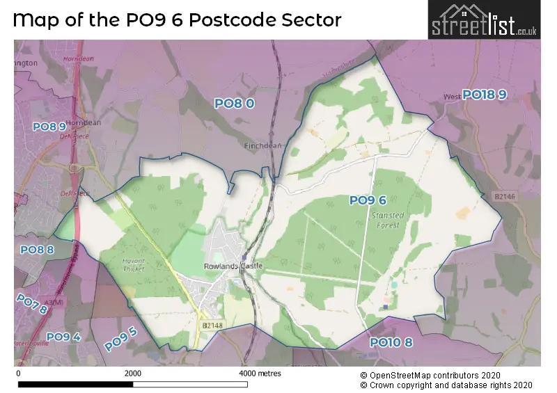
The PO9 6 Postcode shares a border with PO8 0 (Clanfield, WATERLOOVILLE, Horndean), PO8 8 (WATERLOOVILLE, Cowplain), PO8 9 (WATERLOOVILLE, Horndean), PO9 4 (HAVANT), PO9 5 (HAVANT), PO10 7 (EMSWORTH), PO10 8 (EMSWORTH, Southbourne, Westbourne) and PO18 9 (Funtington, Compton, Chilgrove).
The sector is within the post town of ROWLAND'S CASTLE.
PO9 6 is a postcode sector within the PO8 postcode district which is within the PO Portsmouth postcode area.
The Royal Mail delivery office for the PO9 6 postal sector is the unknown.
The area of the PO9 6 postcode sector is 8.48 square miles which is 21.97 square kilometres or 5,428.07 square acres.
The PO9 6 postcode sector is crossed by the A3M Major A road.

Map of the PO9 6 Postcode Sector
Explore the PO9 6 postcode sector by using our free interactive map.
| P | O | 9 | - | 6 | X | X |
| P | O | 9 | Space | 6 | Letter | Letter |
Official List of Streets
ROWLAND'S CASTLE (44 Streets)
Forestside (2 Streets)
Stansted Park (1 Streets)
Stansted (1 Streets)
Unofficial Streets or Alternative Spellings
EMSWORTH,
WOODBERRY LANEHorndean
ROWLANDS CASTLE ROADHAVANT
PETERSFIELD ROADWeather Forecast for PO9 6
Press Button to Show Forecast for Walderton
| Time Period | Icon | Description | Temperature | Rain Probability | Wind |
|---|---|---|---|---|---|
| 15:00 to 18:00 | Cloudy | 10.0°C (feels like 8.0°C) | 5.00% | N 9 mph | |
| 18:00 to 21:00 | Cloudy | 10.0°C (feels like 9.0°C) | 4.00% | N 4 mph | |
| 21:00 to 00:00 | Cloudy | 7.0°C (feels like 6.0°C) | 4.00% | N 2 mph |
Press Button to Show Forecast for Walderton
| Time Period | Icon | Description | Temperature | Rain Probability | Wind |
|---|---|---|---|---|---|
| 00:00 to 03:00 | Cloudy | 7.0°C (feels like 6.0°C) | 4.00% | WSW 2 mph | |
| 03:00 to 06:00 | Overcast | 7.0°C (feels like 5.0°C) | 11.00% | S 4 mph | |
| 06:00 to 09:00 | Partly cloudy (day) | 7.0°C (feels like 5.0°C) | 6.00% | WSW 7 mph | |
| 09:00 to 12:00 | Sunny day | 9.0°C (feels like 8.0°C) | 2.00% | WNW 9 mph | |
| 12:00 to 15:00 | Overcast | 11.0°C (feels like 9.0°C) | 15.00% | W 9 mph | |
| 15:00 to 18:00 | Light rain | 10.0°C (feels like 8.0°C) | 49.00% | W 9 mph | |
| 18:00 to 21:00 | Cloudy | 9.0°C (feels like 8.0°C) | 50.00% | WSW 7 mph | |
| 21:00 to 00:00 | Cloudy | 7.0°C (feels like 6.0°C) | 6.00% | NNW 4 mph |
Press Button to Show Forecast for Walderton
| Time Period | Icon | Description | Temperature | Rain Probability | Wind |
|---|---|---|---|---|---|
| 00:00 to 03:00 | Cloudy | 6.0°C (feels like 4.0°C) | 9.00% | NE 7 mph | |
| 03:00 to 06:00 | Cloudy | 6.0°C (feels like 3.0°C) | 7.00% | NE 7 mph | |
| 06:00 to 09:00 | Cloudy | 6.0°C (feels like 2.0°C) | 9.00% | NE 9 mph | |
| 09:00 to 12:00 | Overcast | 7.0°C (feels like 4.0°C) | 12.00% | ENE 11 mph | |
| 12:00 to 15:00 | Cloudy | 10.0°C (feels like 7.0°C) | 16.00% | E 9 mph | |
| 15:00 to 18:00 | Overcast | 10.0°C (feels like 9.0°C) | 17.00% | ENE 7 mph | |
| 18:00 to 21:00 | Cloudy | 10.0°C (feels like 8.0°C) | 12.00% | E 7 mph | |
| 21:00 to 00:00 | Cloudy | 7.0°C (feels like 5.0°C) | 12.00% | E 7 mph |
Press Button to Show Forecast for Walderton
| Time Period | Icon | Description | Temperature | Rain Probability | Wind |
|---|---|---|---|---|---|
| 00:00 to 03:00 | Overcast | 6.0°C (feels like 3.0°C) | 22.00% | ENE 9 mph | |
| 03:00 to 06:00 | Light rain | 5.0°C (feels like 2.0°C) | 50.00% | ENE 9 mph | |
| 06:00 to 09:00 | Cloudy | 6.0°C (feels like 3.0°C) | 18.00% | NE 9 mph | |
| 09:00 to 12:00 | Cloudy | 9.0°C (feels like 7.0°C) | 15.00% | ENE 11 mph | |
| 12:00 to 15:00 | Cloudy | 11.0°C (feels like 9.0°C) | 15.00% | E 11 mph | |
| 15:00 to 18:00 | Light rain | 11.0°C (feels like 9.0°C) | 47.00% | ENE 11 mph | |
| 18:00 to 21:00 | Light rain | 10.0°C (feels like 8.0°C) | 50.00% | ENE 11 mph | |
| 21:00 to 00:00 | Light rain | 9.0°C (feels like 6.0°C) | 49.00% | ENE 13 mph |
Press Button to Show Forecast for Walderton
| Time Period | Icon | Description | Temperature | Rain Probability | Wind |
|---|---|---|---|---|---|
| 00:00 to 03:00 | Heavy rain | 9.0°C (feels like 6.0°C) | 76.00% | ENE 11 mph | |
| 03:00 to 06:00 | Heavy rain shower (night) | 8.0°C (feels like 6.0°C) | 61.00% | ENE 9 mph | |
| 06:00 to 09:00 | Light rain | 9.0°C (feels like 7.0°C) | 51.00% | ESE 9 mph | |
| 09:00 to 12:00 | Light rain shower (day) | 11.0°C (feels like 9.0°C) | 43.00% | SE 9 mph | |
| 12:00 to 15:00 | Light rain shower (day) | 12.0°C (feels like 10.0°C) | 42.00% | SW 11 mph | |
| 15:00 to 18:00 | Light rain shower (day) | 12.0°C (feels like 10.0°C) | 40.00% | WSW 13 mph | |
| 18:00 to 21:00 | Cloudy | 11.0°C (feels like 8.0°C) | 14.00% | WSW 11 mph | |
| 21:00 to 00:00 | Partly cloudy (night) | 9.0°C (feels like 7.0°C) | 8.00% | WSW 7 mph |
Schools and Places of Education Within the PO9 6 Postcode Sector
Rowlands Castle St John's Church of England Controlled Primary School
Voluntary controlled school
Whichers Gate Road, Rowland's Castle, Hampshire, PO9 6BB
Head: Mrs Jayne Pavitt
Ofsted Rating: Good
Inspection: 2022-02-16 (798 days ago)
Website: Visit Rowlands Castle St John's Church of England Controlled Primary School Website
Phone: 02392412095
Number of Pupils: 206
House Prices in the PO9 6 Postcode Sector
| Type of Property | 2018 Average | 2018 Sales | 2017 Average | 2017 Sales | 2016 Average | 2016 Sales | 2015 Average | 2015 Sales |
|---|---|---|---|---|---|---|---|---|
| Detached | £617,192 | 34 | £620,994 | 18 | £625,936 | 24 | £524,987 | 25 |
| Semi-Detached | £374,334 | 18 | £423,885 | 13 | £380,181 | 8 | £281,900 | 10 |
| Terraced | £285,577 | 13 | £260,589 | 9 | £272,000 | 12 | £299,800 | 5 |
| Flats | £166,111 | 9 | £188,499 | 5 | £220,000 | 5 | £180,125 | 4 |
Important Postcodes PO9 6 in the Postcode Sector
PO9 6BB is the postcode for St. Johns C of E Primary School, Whichers Gate Road
| The PO9 6 Sector is within these Local Authorities |
|
|---|---|
| The PO9 6 Sector is within these Counties |
|
| The PO9 6 Sector is within these Water Company Areas |
|
Tourist Attractions within the PO9 6 Postcode Area
We found 2 visitor attractions within the PO8 postcode area
| Stansted House |
|---|
| Historic Properties |
| Historic House / House and Garden / Palace |
| View Stansted House on Google Maps |
| Stansted Park Foundation |
| Historic Properties |
| Historic House / House and Garden / Palace |
| View Stansted Park Foundation on Google Maps |