The PR1 9 postcode sector is within the county of Lancashire.
Did you know? According to the 2021 Census, the PR1 9 postcode sector is home to a bustling 12,867 residents!
Given that each sector allows for 400 unique postcode combinations. Letters C, I, K, M, O and V are not allowed in the last two letters of a postcode. With 281 postcodes already in use, this leaves 119 units available.
The PR1 9 postal code covers the settlement of Penwortham.
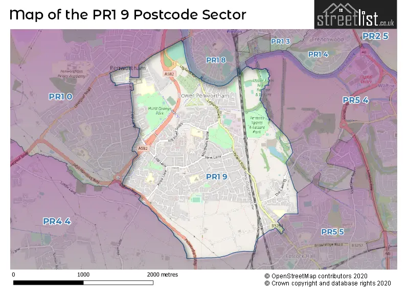
The PR1 9 Postcode shares a border with PR5 4 (Walton-le-Dale, Higher Walton), PR5 5 (Lostock Hall), PR1 8 (PRESTON), PR1 0 (Penwortham) and PR4 4 (New Longton, Much Hoole, Whitestake).
The sector is within the post town of PRESTON.
PR1 9 is a postcode sector within the PR1 postcode district which is within the PR Preston postcode area.
The Royal Mail delivery office for the PR1 9 postal sector is the Preston Central Delivery Office.
The area of the PR1 9 postcode sector is 2.04 square miles which is 5.28 square kilometres or 1,303.50 square acres.

Map of the PR1 9 Postcode Sector
Explore the PR1 9 postcode sector by using our free interactive map.
| P | R | 1 | - | 9 | X | X |
| P | R | 1 | Space | 9 | Letter | Letter |
Official List of Streets
Penwortham (210 Streets)
Unofficial Streets or Alternative Spellings
Penwortham
BROAD OAK LANE KEW GARDENS KINGSWAY MANOR LANE MILLBROOK WAY OAK AVENUE QUEENSWAY THE AVENUE WALTON AVENUE DICKINSONS FIELD GOLDEN WAY GUILD WAY HOLME ROAD OAKS WOOD OLD LANE FARM BARN PARK CLOSE PARK ROAD PARK VIEW PARK WAY PENWORTHAM BROW PENWORTHAM OLD BRIDGE ROSE FOLD THE MALTINGS WOODLAND GRANGEWalton-le-Dale
OAKLAND GLENLostock Hall
FIR TREES ROAD LEYLAND ROAD MARINA GROVEWhitestake
PENWORTHAM WAYHutton
LIVERPOOL ROADWeather Forecast for PR1 9
Press Button to Show Forecast for Preston
| Time Period | Icon | Description | Temperature | Rain Probability | Wind |
|---|---|---|---|---|---|
| 06:00 to 09:00 | Sunny day | 5.0°C (feels like 3.0°C) | 0.00% | NNE 4 mph | |
| 09:00 to 12:00 | Partly cloudy (day) | 7.0°C (feels like 6.0°C) | 0.00% | N 4 mph | |
| 12:00 to 15:00 | Partly cloudy (day) | 10.0°C (feels like 9.0°C) | 0.00% | NNW 7 mph | |
| 15:00 to 18:00 | Sunny day | 10.0°C (feels like 8.0°C) | 0.00% | NW 11 mph | |
| 18:00 to 21:00 | Sunny day | 9.0°C (feels like 7.0°C) | 0.00% | NW 9 mph | |
| 21:00 to 00:00 | Clear night | 7.0°C (feels like 5.0°C) | 1.00% | NW 7 mph |
Press Button to Show Forecast for Preston
| Time Period | Icon | Description | Temperature | Rain Probability | Wind |
|---|---|---|---|---|---|
| 00:00 to 03:00 | Cloudy | 7.0°C (feels like 5.0°C) | 3.00% | WNW 7 mph | |
| 03:00 to 06:00 | Cloudy | 6.0°C (feels like 4.0°C) | 5.00% | WNW 7 mph | |
| 06:00 to 09:00 | Cloudy | 7.0°C (feels like 4.0°C) | 5.00% | WNW 7 mph | |
| 09:00 to 12:00 | Partly cloudy (day) | 8.0°C (feels like 6.0°C) | 3.00% | NW 9 mph | |
| 12:00 to 15:00 | Cloudy | 10.0°C (feels like 8.0°C) | 7.00% | NW 9 mph | |
| 15:00 to 18:00 | Cloudy | 10.0°C (feels like 8.0°C) | 7.00% | NW 9 mph | |
| 18:00 to 21:00 | Cloudy | 9.0°C (feels like 8.0°C) | 7.00% | NNW 4 mph | |
| 21:00 to 00:00 | Cloudy | 6.0°C (feels like 4.0°C) | 13.00% | ENE 7 mph |
Press Button to Show Forecast for Preston
| Time Period | Icon | Description | Temperature | Rain Probability | Wind |
|---|---|---|---|---|---|
| 00:00 to 03:00 | Cloudy | 5.0°C (feels like 3.0°C) | 6.00% | E 7 mph | |
| 03:00 to 06:00 | Cloudy | 4.0°C (feels like 2.0°C) | 6.00% | E 7 mph | |
| 06:00 to 09:00 | Cloudy | 5.0°C (feels like 2.0°C) | 15.00% | E 7 mph | |
| 09:00 to 12:00 | Cloudy | 7.0°C (feels like 5.0°C) | 16.00% | ESE 9 mph | |
| 12:00 to 15:00 | Overcast | 9.0°C (feels like 7.0°C) | 13.00% | ESE 7 mph | |
| 15:00 to 18:00 | Cloudy | 10.0°C (feels like 8.0°C) | 19.00% | ESE 7 mph | |
| 18:00 to 21:00 | Cloudy | 9.0°C (feels like 8.0°C) | 9.00% | E 7 mph | |
| 21:00 to 00:00 | Cloudy | 8.0°C (feels like 5.0°C) | 9.00% | E 9 mph |
Press Button to Show Forecast for Preston
| Time Period | Icon | Description | Temperature | Rain Probability | Wind |
|---|---|---|---|---|---|
| 00:00 to 03:00 | Cloudy | 6.0°C (feels like 4.0°C) | 9.00% | E 9 mph | |
| 03:00 to 06:00 | Cloudy | 6.0°C (feels like 3.0°C) | 11.00% | E 7 mph | |
| 06:00 to 09:00 | Cloudy | 6.0°C (feels like 3.0°C) | 11.00% | E 9 mph | |
| 09:00 to 12:00 | Cloudy | 8.0°C (feels like 6.0°C) | 11.00% | E 11 mph | |
| 12:00 to 15:00 | Overcast | 11.0°C (feels like 9.0°C) | 14.00% | E 11 mph | |
| 15:00 to 18:00 | Cloudy | 11.0°C (feels like 9.0°C) | 14.00% | E 11 mph | |
| 18:00 to 21:00 | Partly cloudy (day) | 10.0°C (feels like 8.0°C) | 10.00% | ENE 9 mph | |
| 21:00 to 00:00 | Cloudy | 8.0°C (feels like 6.0°C) | 12.00% | ENE 9 mph |
Schools and Places of Education Within the PR1 9 Postcode Sector
Cop Lane Church of England Primary School, Penwortham
Voluntary aided school
Cop Lane, Preston, Lancashire, PR1 9AE
Head: Mr Ian Ashmore
Ofsted Rating: Outstanding
Inspection: 2013-03-14 (4059 days ago)
Website: Visit Cop Lane Church of England Primary School, Penwortham Website
Phone: 01772743131
Number of Pupils: 213
Kingsfold Primary School
Community school
Martinfield Road, PRESTON, Lancashire, PR1 9HJ
Head: Mrs Kellie Tierney
Ofsted Rating: Good
Inspection: 2022-11-30 (511 days ago)
Website: Visit Kingsfold Primary School Website
Phone: 01772743531
Number of Pupils: 116
Penwortham Broad Oak Primary School
Foundation school
Pope Lane, Preston, Lancashire, PR1 9DE
Head: Miss Sarah Barton
Ofsted Rating: Good
Inspection: 2022-09-22 (580 days ago)
Website: Visit Penwortham Broad Oak Primary School Website
Phone: 01772749511
Number of Pupils: 198
Penwortham Middleforth Church of England Primary School
Voluntary controlled school
Hill Road South, Preston, Lancashire, PR1 9YE
Head: Mrs Nicola Pilkington
Ofsted Rating: Good
Inspection: 2023-04-19 (371 days ago)
Website: Visit Penwortham Middleforth Church of England Primary School Website
Phone: 01772746024
Number of Pupils: 199
St Mary Magdalen's Catholic Primary School
Voluntary aided school
Buller Avenue, Preston, Lancashire, PR1 9QQ
Head: Claire McKinnon
Ofsted Rating: Good
Inspection: 2019-02-14 (1896 days ago)
Website: Visit St Mary Magdalen's Catholic Primary School Website
Phone: 01772742351
Number of Pupils: 197
House Prices in the PR1 9 Postcode Sector
| Type of Property | 2018 Average | 2018 Sales | 2017 Average | 2017 Sales | 2016 Average | 2016 Sales | 2015 Average | 2015 Sales |
|---|---|---|---|---|---|---|---|---|
| Detached | £273,701 | 62 | £234,640 | 42 | £239,435 | 56 | £227,449 | 83 |
| Semi-Detached | £151,267 | 119 | £153,780 | 95 | £147,819 | 129 | £142,636 | 94 |
| Terraced | £134,500 | 63 | £123,961 | 36 | £114,179 | 41 | £112,448 | 52 |
| Flats | £85,245 | 10 | £76,653 | 16 | £82,420 | 10 | £68,079 | 8 |
Important Postcodes PR1 9 in the Postcode Sector
PR1 9AE is the postcode for MAIN BUILDING, Cop Lane C of E Primary School, Cop Lane, and Cop Lane C of E Primary School, Cop Lane
PR1 9DE is the postcode for Penwortham Broad Oak County School, Pope Lane
PR1 9EJ is the postcode for Lancashire County Council, Kingsfold Library, Hawksbury Drive
PR1 9HJ is the postcode for MAIN BUILDING, Kingsfold Primary School, Martinfield Road, and Kingsfold Primary School, Martinfield Road
PR1 9QQ is the postcode for St. Mary Magdelenes School, Buller Avenue
PR1 9YE is the postcode for Middleforth C of E School, Hill Road South, Penwortham, and Middleforth C of E School, Hill Road South
| The PR1 9 Sector is within these Local Authorities |
|
|---|---|
| The PR1 9 Sector is within these Counties |
|
| The PR1 9 Sector is within these Water Company Areas |
|