The PR3 5 postcode sector is within the county of Lancashire.
Did you know? According to the 2021 Census, the PR3 5 postcode sector is home to a bustling 3,436 residents!
Given that each sector allows for 400 unique postcode combinations. Letters C, I, K, M, O and V are not allowed in the last two letters of a postcode. With 85 postcodes already in use, this leaves 315 units available.
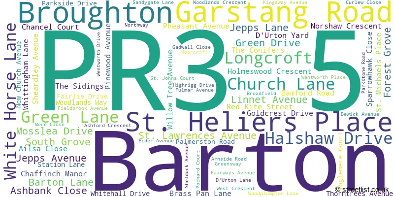
The largest settlements in the PR3 5 postal code are Broughton and Barton.
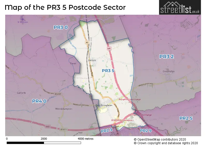
The PR3 5 Postcode shares a border with PR2 9 (Fulwood), PR3 0 (Great Eccleston, Forton, Catterall), PR3 2 (Goosnargh, Longridge, Whittingham), PR2 3 (Fulwood, Ingol, PRESTON), PR2 5 (Grimsargh, Ribbleton, Haighton) and PR4 0 (Cottam, Woodplumpton, Clifton).
The sector is within the post town of PRESTON.
PR3 5 is a postcode sector within the PR3 postcode district which is within the PR Preston postcode area.
The Royal Mail delivery office for the PR3 5 postal sector is the Preston Central Delivery Office.
The area of the PR3 5 postcode sector is 5.62 square miles which is 14.55 square kilometres or 3,596.52 square acres.
The PR3 5 postcode sector is crossed by the M55 motorway.
The PR3 5 postcode sector is crossed by the M6 motorway.
Waterways within the PR3 5 postcode sector include the Lancaster Canal.

Map of the PR3 5 Postcode Sector
Explore the PR3 5 postcode sector by using our free interactive map.
| P | R | 3 | - | 5 | X | X |
| P | R | 3 | Space | 5 | Letter | Letter |
Official List of Streets
Barton (28 Streets)
Broughton (52 Streets)
Unofficial Streets or Alternative Spellings
Goosnargh
LANGLEY LANE ASH BANK CLOSE BROUGHTON ROUNDABOUT DOWNING COURT EGRET CLOSE GUILD WHEEL HARRIER WAY JAMES TOWERS WAY KINGSWAY COURT LAURUS GROVE MERICOURT ROAD MYERSCOUGH PLANKS NEWT GARDENS PALMER CLOSE PRESTON NORTHERN BY-PASS PRINGLE WOOD REDWING DRIVE SAINT JOHNS COURT SANDY GATE LANE SHEARWATER DRIVE TEAL AVENUE VICTORIA COURT WHITTINGHAM PLACE WITTON ROADWoodplumpton
MOSS HOUSE ROAD NEWSHAM HALL LANEFulwood
EASTWAY HERON DRIVE MIDGERY LANEWeather Forecast for PR3 5
Press Button to Show Forecast for Myerscough
| Time Period | Icon | Description | Temperature | Rain Probability | Wind |
|---|---|---|---|---|---|
| 15:00 to 18:00 | Cloudy | 10.0°C (feels like 9.0°C) | 33.00% | NW 7 mph | |
| 18:00 to 21:00 | Cloudy | 8.0°C (feels like 6.0°C) | 6.00% | NE 7 mph | |
| 21:00 to 00:00 | Cloudy | 6.0°C (feels like 4.0°C) | 6.00% | E 7 mph |
Press Button to Show Forecast for Myerscough
| Time Period | Icon | Description | Temperature | Rain Probability | Wind |
|---|---|---|---|---|---|
| 00:00 to 03:00 | Partly cloudy (night) | 4.0°C (feels like 1.0°C) | 2.00% | E 7 mph | |
| 03:00 to 06:00 | Clear night | 2.0°C (feels like -1.0°C) | 1.00% | E 7 mph | |
| 06:00 to 09:00 | Sunny day | 3.0°C (feels like 0.0°C) | 1.00% | ENE 4 mph | |
| 09:00 to 12:00 | Partly cloudy (day) | 7.0°C (feels like 6.0°C) | 1.00% | E 7 mph | |
| 12:00 to 15:00 | Cloudy | 9.0°C (feels like 8.0°C) | 6.00% | E 4 mph | |
| 15:00 to 18:00 | Cloudy | 10.0°C (feels like 9.0°C) | 9.00% | NE 4 mph | |
| 18:00 to 21:00 | Cloudy | 9.0°C (feels like 7.0°C) | 5.00% | N 7 mph | |
| 21:00 to 00:00 | Partly cloudy (night) | 5.0°C (feels like 3.0°C) | 3.00% | NE 7 mph |
Press Button to Show Forecast for Myerscough
| Time Period | Icon | Description | Temperature | Rain Probability | Wind |
|---|---|---|---|---|---|
| 00:00 to 03:00 | Partly cloudy (night) | 4.0°C (feels like 2.0°C) | 3.00% | E 7 mph | |
| 03:00 to 06:00 | Partly cloudy (night) | 3.0°C (feels like 1.0°C) | 4.00% | E 7 mph | |
| 06:00 to 09:00 | Partly cloudy (day) | 4.0°C (feels like 2.0°C) | 4.00% | ENE 7 mph | |
| 09:00 to 12:00 | Cloudy | 9.0°C (feels like 7.0°C) | 8.00% | E 9 mph | |
| 12:00 to 15:00 | Overcast | 11.0°C (feels like 9.0°C) | 12.00% | E 9 mph | |
| 15:00 to 18:00 | Cloudy | 11.0°C (feels like 9.0°C) | 11.00% | E 7 mph | |
| 18:00 to 21:00 | Cloudy | 10.0°C (feels like 8.0°C) | 12.00% | ENE 9 mph | |
| 21:00 to 00:00 | Partly cloudy (night) | 7.0°C (feels like 5.0°C) | 10.00% | ENE 9 mph |
Press Button to Show Forecast for Myerscough
| Time Period | Icon | Description | Temperature | Rain Probability | Wind |
|---|---|---|---|---|---|
| 00:00 to 03:00 | Cloudy | 6.0°C (feels like 3.0°C) | 14.00% | NE 9 mph | |
| 03:00 to 06:00 | Cloudy | 5.0°C (feels like 3.0°C) | 14.00% | NNE 9 mph | |
| 06:00 to 09:00 | Light rain | 7.0°C (feels like 4.0°C) | 44.00% | NNE 9 mph | |
| 09:00 to 12:00 | Cloudy | 8.0°C (feels like 6.0°C) | 19.00% | NNE 9 mph | |
| 12:00 to 15:00 | Light rain | 9.0°C (feels like 7.0°C) | 48.00% | NNE 11 mph | |
| 15:00 to 18:00 | Light rain | 10.0°C (feels like 8.0°C) | 51.00% | N 9 mph | |
| 18:00 to 21:00 | Partly cloudy (day) | 10.0°C (feels like 8.0°C) | 13.00% | NNW 11 mph | |
| 21:00 to 00:00 | Clear night | 8.0°C (feels like 5.0°C) | 9.00% | NW 9 mph |
Schools and Places of Education Within the PR3 5 Postcode Sector
Barton St Lawrence Church of England Primary School
Voluntary aided school
Jepps Avenue, Preston, Lancashire, PR3 5AS
Head: Mrs Julie Goodwin
Ofsted Rating: Outstanding
Inspection: 2023-11-29 (148 days ago)
Website: Visit Barton St Lawrence Church of England Primary School Website
Phone: 01772862664
Number of Pupils: 195
Broughton High School
Community school
Woodplumpton Lane, Preston, Lancashire, PR3 5JJ
Head: Mr David Botes
Ofsted Rating: Outstanding
Inspection: 2022-09-28 (575 days ago)
Website: Visit Broughton High School Website
Phone: 01772863849
Number of Pupils: 917
Broughton-in-Amounderness Church of England Primary School
Voluntary aided school
Church Lane, Preston, Lancashire, PR3 5JB
Head: Mr Oliver McPhail
Ofsted Rating: Outstanding
Inspection: 2012-11-21 (4173 days ago)
Website: Visit Broughton-in-Amounderness Church of England Primary School Website
Phone: 01772862788
Number of Pupils: 298
St Mary and St Andrew's Catholic Primary School, Barton Newsham
Voluntary aided school
Station Lane, Preston, Lancashire, PR3 5DY
Head: Mrs Sarah Roach
Ofsted Rating: Good
Inspection: 2019-03-27 (1856 days ago)
Website: Visit St Mary and St Andrew's Catholic Primary School, Barton Newsham Website
Phone: 01772862335
Number of Pupils: 130
House Prices in the PR3 5 Postcode Sector
| Type of Property | 2018 Average | 2018 Sales | 2017 Average | 2017 Sales | 2016 Average | 2016 Sales | 2015 Average | 2015 Sales |
|---|---|---|---|---|---|---|---|---|
| Detached | £319,356 | 43 | £342,060 | 48 | £309,415 | 38 | £330,703 | 42 |
| Semi-Detached | £180,665 | 25 | £228,000 | 18 | £186,378 | 24 | £187,426 | 26 |
| Terraced | £138,332 | 13 | £105,750 | 2 | £114,200 | 5 | £138,059 | 5 |
| Flats | £149,950 | 3 | £123,000 | 1 | £0 | 0 | £0 | 0 |
Important Postcodes PR3 5 in the Postcode Sector
PR3 5AS is the postcode for Barton C of E School, Jepps Avenue
PR3 5DY is the postcode for St. Marys & St. Andrews Primary School, Station Lane
PR3 5HE is the postcode for Department for Environment Food & Rural Affairs (D E F R A), Barton Hall, Garstang Road
PR3 5JB is the postcode for MAIN BUILDING, Broughton C of E Primary School, Garstang Road, and Broughton C of E Primary School, Garstang Road
PR3 5JJ is the postcode for SENIOR BLOCK, Broughton Business & Enterprise College, Woodplumpton Lane, Broughton Business & Enterprise College, Woodplumpton Lane, SPORTS HALL, Broughton Business & Enterprise College, Woodplumpton Lane, GYMNASIUM/BUSINESS CENTRE, Broughton Business & Enterprise College, Woodplumpton Lane, and JUNIOR BLOCK, Broughton Business & Enterprise College, Woodplumpton Lane
PR3 5LN is the postcode for FLEET MAINTENANCE BUILDING, North West Ambulance Service NHS Trust, Ambulance Headquarters, 449-451 Garstang Road
| The PR3 5 Sector is within these Local Authorities |
|
|---|---|
| The PR3 5 Sector is within these Counties |
|
| The PR3 5 Sector is within these Water Company Areas |
|