The PR5 postcode district is a postal district located in the PR Preston postcode area with a population of 40,633 residents according to the 2021 England and Wales Census.
The area of the PR5 postcode district is 19.42 square miles which is 50.31 square kilometres or 12,430.76 acres.
Currently, the PR5 district has about 974 postcode units spread across 5 geographic postcode sectors.
Given that each sector allows for 400 unique postcode combinations, the district has a capacity of 2,000 postcodes. With 974 postcodes already in use, this leaves 1026 units available.
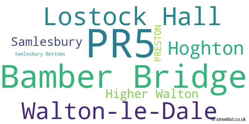
The largest settlement in the PR5 postal code is Bamber Bridge followed by Lostock Hall, and Walton-le-Dale.
The PR5 Postcode shares a border with PR6 (CHORLEY, Whittle-le-Woods, Clayton-le-Woods), BB2 (BLACKBURN, Mellor, Mellor Brook), PR1 (PRESTON, Penwortham), PR2 (Fulwood, Ashton-on-Ribble, Ribbleton) and PR26 (LEYLAND, Croston, Farington Moss).
The primary settlement in the PR5 postcode district is Preston in Lancashire, which has a count of 1. Other significant settlements in the district include Hoghton, Samlesbury, Samlesbury Bottoms, Higher Walton, Walton-le-Dale, Lostock Hall, and Bamber Bridge. Lancashire is the county where these settlements are located. The post town for the PR5 postcode district is Preston.
For the district PR5, we have data on 6 postcode sectors. Here's a breakdown: The sector PR5 0, covers Hoghton and Samlesbury in Lancashire. The sector PR5 4, covers Walton-Le-Dale and Higher Walton in Lancashire. The sector PR5 5, covers Lostock Hall in Lancashire. The sector PR5 6, covers Bamber Bridge in Lancashire. The sector PR5 8, covers Bamber Bridge in Lancashire. The sector PR5 9 is non-geographic. It's often designated for PO Boxes, large organisations, or special services.

Map of the PR5 Postcode District
Explore the PR5 postcode district by using our free interactive map.
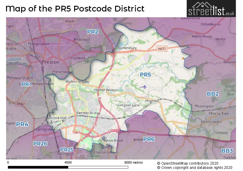
When it comes to local government, postal geography often disregards political borders. However, for a breakdown in the PR5 District: the district mostly encompasses the South Ribble District (B) (856 postcodes), and finally, the Chorley District (B) area (121 postcodes).
Recent House Sales in PR5
| Date | Price | Address |
|---|---|---|
| 25/10/2023 | £85,000 | Watkin Lane, Lostock Hall, Preston, PR5 5HA |
| 24/10/2023 | £355,000 | Simmons Avenue, Walton-le-dale, Preston, PR5 4LX |
| 12/10/2023 | £165,000 | Doodstone Avenue, Lostock Hall, Preston, PR5 5TY |
| 06/10/2023 | £137,500 | Conway Court, Hoghton, Preston, PR5 0EP |
| 28/09/2023 | £137,000 | Townsway, Lostock Hall, Preston, PR5 5YQ |
| 21/09/2023 | £265,000 | Central Avenue, Hoghton, Preston, PR5 0JX |
| 18/09/2023 | £172,000 | Brownedge Road, Lostock Hall, Preston, PR5 5AD |
| 15/09/2023 | £145,000 | Methuen Avenue, Hoghton, Preston, PR5 0JN |
| 14/09/2023 | £178,000 | Airey Houses, Samlesbury, Preston, PR5 0XA |
| 13/09/2023 | £177,000 | Lostock View, Lostock Hall, Preston, PR5 5LS |
Weather Forecast for PR5
Press Button to Show Forecast for Bamber Bridge
| Time Period | Icon | Description | Temperature | Rain Probability | Wind |
|---|---|---|---|---|---|
| 03:00 to 06:00 | Cloudy | 6.0°C (feels like 4.0°C) | 5.00% | W 7 mph | |
| 06:00 to 09:00 | Cloudy | 6.0°C (feels like 4.0°C) | 44.00% | WNW 7 mph | |
| 09:00 to 12:00 | Cloudy | 8.0°C (feels like 6.0°C) | 6.00% | NW 9 mph | |
| 12:00 to 15:00 | Cloudy | 9.0°C (feels like 7.0°C) | 47.00% | NNE 9 mph | |
| 15:00 to 18:00 | Cloudy | 10.0°C (feels like 9.0°C) | 9.00% | N 4 mph | |
| 18:00 to 21:00 | Cloudy | 8.0°C (feels like 7.0°C) | 8.00% | NE 7 mph | |
| 21:00 to 00:00 | Cloudy | 6.0°C (feels like 4.0°C) | 5.00% | ENE 7 mph |
Press Button to Show Forecast for Bamber Bridge
| Time Period | Icon | Description | Temperature | Rain Probability | Wind |
|---|---|---|---|---|---|
| 00:00 to 03:00 | Partly cloudy (night) | 4.0°C (feels like 1.0°C) | 1.00% | ENE 7 mph | |
| 03:00 to 06:00 | Partly cloudy (night) | 2.0°C (feels like -1.0°C) | 1.00% | ENE 4 mph | |
| 06:00 to 09:00 | Sunny day | 2.0°C (feels like -1.0°C) | 1.00% | ENE 4 mph | |
| 09:00 to 12:00 | Partly cloudy (day) | 7.0°C (feels like 6.0°C) | 5.00% | ENE 4 mph | |
| 12:00 to 15:00 | Cloudy | 9.0°C (feels like 8.0°C) | 6.00% | E 4 mph | |
| 15:00 to 18:00 | Cloudy | 10.0°C (feels like 9.0°C) | 6.00% | ENE 4 mph | |
| 18:00 to 21:00 | Cloudy | 9.0°C (feels like 7.0°C) | 5.00% | NNE 7 mph | |
| 21:00 to 00:00 | Cloudy | 5.0°C (feels like 3.0°C) | 5.00% | NE 7 mph |
Press Button to Show Forecast for Bamber Bridge
| Time Period | Icon | Description | Temperature | Rain Probability | Wind |
|---|---|---|---|---|---|
| 00:00 to 03:00 | Partly cloudy (night) | 4.0°C (feels like 2.0°C) | 3.00% | E 4 mph | |
| 03:00 to 06:00 | Partly cloudy (night) | 3.0°C (feels like 0.0°C) | 5.00% | ENE 7 mph | |
| 06:00 to 09:00 | Partly cloudy (day) | 4.0°C (feels like 1.0°C) | 4.00% | ENE 7 mph | |
| 09:00 to 12:00 | Cloudy | 8.0°C (feels like 7.0°C) | 8.00% | E 7 mph | |
| 12:00 to 15:00 | Overcast | 11.0°C (feels like 9.0°C) | 13.00% | E 9 mph | |
| 15:00 to 18:00 | Cloudy | 11.0°C (feels like 9.0°C) | 15.00% | E 7 mph | |
| 18:00 to 21:00 | Cloudy | 9.0°C (feels like 8.0°C) | 15.00% | ENE 9 mph | |
| 21:00 to 00:00 | Partly cloudy (night) | 7.0°C (feels like 4.0°C) | 11.00% | ENE 9 mph |
Press Button to Show Forecast for Bamber Bridge
| Time Period | Icon | Description | Temperature | Rain Probability | Wind |
|---|---|---|---|---|---|
| 00:00 to 03:00 | Cloudy | 5.0°C (feels like 3.0°C) | 14.00% | NE 9 mph | |
| 03:00 to 06:00 | Cloudy | 5.0°C (feels like 2.0°C) | 16.00% | NNE 7 mph | |
| 06:00 to 09:00 | Cloudy | 6.0°C (feels like 4.0°C) | 20.00% | NNE 7 mph | |
| 09:00 to 12:00 | Cloudy | 8.0°C (feels like 6.0°C) | 21.00% | NE 9 mph | |
| 12:00 to 15:00 | Light rain | 9.0°C (feels like 7.0°C) | 55.00% | NNE 9 mph | |
| 15:00 to 18:00 | Heavy rain | 10.0°C (feels like 8.0°C) | 77.00% | N 9 mph | |
| 18:00 to 21:00 | Light rain shower (day) | 10.0°C (feels like 8.0°C) | 37.00% | NNW 9 mph | |
| 21:00 to 00:00 | Clear night | 7.0°C (feels like 5.0°C) | 11.00% | NNW 7 mph |
Where is the PR5 Postcode District?
The postcode district PR5 is located in PRESTON, a town in the United Kingdom. PRESTON is surrounded by several nearby towns, including LEYLAND which is located to the South West at a distance of 5.32 miles, CHORLEY to the South at a distance of 5.61 miles, BLACKBURN to the East at a distance of 5.99 miles, DARWEN to the South East at a distance of 7.97 miles, and CLITHEROE to the North East at a distance of 11.62 miles. Moreover, the postcode district PR5 is approximately 186.81 miles away from the center of London.
The district is within the post town of PRESTON.
The sector has postcodes within the nation of England.
The PR5 Postcode District is covers the following regions.
- Mid Lancashire - Lancashire - North West (England)
- Chorley and West Lancashire - Lancashire - North West (England)
| Postcode Sector | Delivery Office |
|---|---|
| PR5 0 | Preston South Delivery Office |
| PR5 4 | Preston South Delivery Office |
| PR5 5 | Preston South Delivery Office |
| PR5 6 | Preston South Delivery Office |
| PR5 8 | Preston South Delivery Office |
| P | R | 5 | - | X | X | X |
| P | R | 5 | Space | Numeric | Letter | Letter |
Tourist Attractions within the Postcode Area
We found 2 visitor attractions within the PR5 postcode area
| Cuerden Valley Park Trust |
|---|
| Country Parks |
| Country Park |
| View Cuerden Valley Park Trust on Google Maps |
| Samlesbury Hall |
| Historic Properties |
| Historic House / House and Garden / Palace |
| View Samlesbury Hall on Google Maps |
Current Monthly Rental Prices
| # Bedrooms | Min Price | Max Price | Avg Price |
|---|---|---|---|
| 1 | £500 | £715 | £602 |
| 2 | £585 | £900 | £694 |
| 3 | £750 | £950 | £865 |
| 4 | £1,100 | £1,500 | £1,213 |
Current House Prices
| # Bedrooms | Min Price | Max Price | Avg Price |
|---|---|---|---|
| 1 | £62,950 | £140,000 | £108,590 |
| 2 | £60,000 | £349,950 | £150,663 |
| 3 | £85,000 | £649,950 | £244,782 |
| 4 | £195,000 | £1,050,000 | £387,207 |
| 5 | £310,000 | £925,000 | £554,466 |
| 6 | £650,000 | £790,000 | £720,000 |
Estate Agents who Operate in the PR5 District
| Logo | Name | Brand Name | Address | Contact Number | Total Properties |
|---|---|---|---|---|---|
 | Bamber Bridge | Bridgfords | 204 Station Road, Bamber Bridge, Preston, Lancashire, PR5 6TQ | 01772 287078 | 44 |
 | Bamber Bridge | Ben Rose Estate Agents | 201 Station Road, Bamber Bridge, PR5 6LB | 01789 335881 | 37 |
 | Bamber Bridge | Reeds Rains | 185 Station Road Station Road Bamber Bridge PR5 6LA | 01772 288285 | 25 |
 | Lostock Hall | Roberts & Co Estate Agents | 50 Watkin Lane, Lostock Hall, Preston, PR5 5RD | 01772 419491 | 24 |
 | covering Bamber Bridge | Farrell Heyworth | 309 Garstang Road Fulwood Preston PR2 9XJ | 01772 598052 | 18 |
| Type of Property | 2018 Average | 2018 Sales | 2017 Average | 2017 Sales | 2016 Average | 2016 Sales | 2015 Average | 2015 Sales |
|---|---|---|---|---|---|---|---|---|
| Detached | £239,582 | 184 | £243,928 | 204 | £225,957 | 183 | £222,560 | 208 |
| Semi-Detached | £145,927 | 308 | £141,978 | 305 | £140,417 | 323 | £135,868 | 343 |
| Terraced | £118,405 | 176 | £112,077 | 191 | £113,763 | 169 | £103,647 | 176 |
| Flats | £81,746 | 12 | £101,716 | 21 | £97,148 | 27 | £87,600 | 25 |