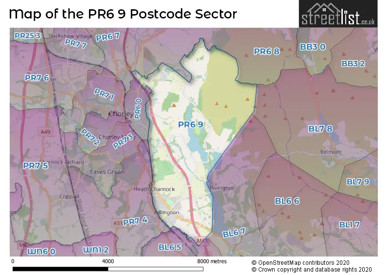
The PR6 9 postcode sector stands on the Greater Manchester and Lancashire border.
Did you know? According to the 2021 Census, the PR6 9 postcode sector is home to a bustling 8,346 residents!
Given that each sector allows for 400 unique postcode combinations. Letters C, I, K, M, O and V are not allowed in the last two letters of a postcode. With 225 postcodes already in use, this leaves 175 units available.
The largest settlement in the PR6 9 postal code is Adlington followed by Heath Charnock, and Anderton.
The PR6 9 Postcode shares a border with PR6 0 (CHORLEY), BL6 5 (Blackrod, Horwich), BL7 8 (Belmont), PR6 7 (Clayton-le-Woods, Whittle-le-Woods, CHORLEY), PR6 8 (Withnell, Brinscall, Brindle), PR7 4 (Coppull, Adlington, CHORLEY) and BL6 7 (Horwich, Rivington).
The sector is within the post town of CHORLEY.
PR6 9 is a postcode sector within the PR6 postcode district which is within the PR Preston postcode area.
The Royal Mail delivery office for the PR6 9 postal sector is the Chorley Delivery Office.
The area of the PR6 9 postcode sector is 9.43 square miles which is 24.42 square kilometres or 6,034.93 square acres.
The PR6 9 postcode sector is crossed by the M61 motorway.
Waterways within the PR6 9 postcode sector include the The Goit, Leeds and Liverpool Canal.

Map of the PR6 9 Postcode Sector
Explore the PR6 9 postcode sector by using our free interactive map.
| P | R | 6 | - | 9 | X | X |
| P | R | 6 | Space | 9 | Letter | Letter |
Official List of Streets
Adlington (70 Streets)
Anderton (19 Streets)
Heath Charnock (24 Streets)
CHORLEY (19 Streets)
Heapey (18 Streets)
Anglezarke (2 Streets)
Unofficial Streets or Alternative Spellings
Adlington
WESTHOUGHTON ROADCHORLEY
HOGGS LANEWeather Forecast for PR6 9
Press Button to Show Forecast for Chorley
| Time Period | Icon | Description | Temperature | Rain Probability | Wind |
|---|---|---|---|---|---|
| 15:00 to 18:00 | Heavy rain | 7.0°C (feels like 4.0°C) | 96.00% | WSW 13 mph | |
| 18:00 to 21:00 | Heavy rain | 9.0°C (feels like 5.0°C) | 84.00% | WSW 16 mph | |
| 21:00 to 00:00 | Light rain | 9.0°C (feels like 6.0°C) | 57.00% | W 13 mph |
Press Button to Show Forecast for Chorley
| Time Period | Icon | Description | Temperature | Rain Probability | Wind |
|---|---|---|---|---|---|
| 00:00 to 03:00 | Light rain | 9.0°C (feels like 5.0°C) | 51.00% | WNW 16 mph | |
| 03:00 to 06:00 | Light rain shower (night) | 8.0°C (feels like 5.0°C) | 45.00% | WNW 16 mph | |
| 06:00 to 09:00 | Cloudy | 8.0°C (feels like 4.0°C) | 43.00% | NW 13 mph | |
| 09:00 to 12:00 | Cloudy | 9.0°C (feels like 5.0°C) | 13.00% | NW 16 mph | |
| 12:00 to 15:00 | Cloudy | 10.0°C (feels like 7.0°C) | 38.00% | NW 18 mph | |
| 15:00 to 18:00 | Cloudy | 10.0°C (feels like 8.0°C) | 50.00% | NNW 13 mph | |
| 18:00 to 21:00 | Cloudy | 10.0°C (feels like 8.0°C) | 4.00% | N 9 mph | |
| 21:00 to 00:00 | Partly cloudy (night) | 7.0°C (feels like 5.0°C) | 1.00% | NNE 7 mph |
Press Button to Show Forecast for Chorley
| Time Period | Icon | Description | Temperature | Rain Probability | Wind |
|---|---|---|---|---|---|
| 00:00 to 03:00 | Partly cloudy (night) | 5.0°C (feels like 4.0°C) | 1.00% | NNE 4 mph | |
| 03:00 to 06:00 | Partly cloudy (night) | 4.0°C (feels like 2.0°C) | 1.00% | NE 4 mph | |
| 06:00 to 09:00 | Partly cloudy (day) | 4.0°C (feels like 2.0°C) | 1.00% | E 2 mph | |
| 09:00 to 12:00 | Sunny day | 7.0°C (feels like 6.0°C) | 1.00% | N 4 mph | |
| 12:00 to 15:00 | Cloudy | 10.0°C (feels like 9.0°C) | 5.00% | NNW 7 mph | |
| 15:00 to 18:00 | Cloudy | 10.0°C (feels like 9.0°C) | 5.00% | NW 7 mph | |
| 18:00 to 21:00 | Partly cloudy (day) | 9.0°C (feels like 8.0°C) | 1.00% | NW 7 mph | |
| 21:00 to 00:00 | Partly cloudy (night) | 6.0°C (feels like 5.0°C) | 1.00% | NNW 4 mph |
Press Button to Show Forecast for Chorley
| Time Period | Icon | Description | Temperature | Rain Probability | Wind |
|---|---|---|---|---|---|
| 00:00 to 03:00 | Partly cloudy (night) | 5.0°C (feels like 4.0°C) | 2.00% | N 2 mph | |
| 03:00 to 06:00 | Cloudy | 4.0°C (feels like 3.0°C) | 5.00% | NNE 2 mph | |
| 06:00 to 09:00 | Cloudy | 6.0°C (feels like 5.0°C) | 13.00% | NNE 2 mph | |
| 09:00 to 12:00 | Cloudy | 9.0°C (feels like 9.0°C) | 5.00% | N 4 mph | |
| 12:00 to 15:00 | Cloudy | 11.0°C (feels like 10.0°C) | 16.00% | N 4 mph | |
| 15:00 to 18:00 | Light rain | 12.0°C (feels like 10.0°C) | 38.00% | NNE 7 mph | |
| 18:00 to 21:00 | Cloudy | 11.0°C (feels like 9.0°C) | 5.00% | NE 7 mph | |
| 21:00 to 00:00 | Partly cloudy (night) | 8.0°C (feels like 6.0°C) | 3.00% | ENE 7 mph |
Press Button to Show Forecast for Chorley
| Time Period | Icon | Description | Temperature | Rain Probability | Wind |
|---|---|---|---|---|---|
| 00:00 to 03:00 | Cloudy | 6.0°C (feels like 4.0°C) | 5.00% | ENE 4 mph | |
| 03:00 to 06:00 | Cloudy | 5.0°C (feels like 4.0°C) | 6.00% | E 4 mph | |
| 06:00 to 09:00 | Cloudy | 6.0°C (feels like 5.0°C) | 6.00% | ENE 4 mph | |
| 09:00 to 12:00 | Cloudy | 9.0°C (feels like 7.0°C) | 6.00% | E 7 mph | |
| 12:00 to 15:00 | Cloudy | 10.0°C (feels like 9.0°C) | 16.00% | ENE 7 mph | |
| 15:00 to 18:00 | Cloudy | 11.0°C (feels like 9.0°C) | 16.00% | NE 7 mph | |
| 18:00 to 21:00 | Cloudy | 10.0°C (feels like 9.0°C) | 7.00% | NE 7 mph | |
| 21:00 to 00:00 | Cloudy | 7.0°C (feels like 6.0°C) | 5.00% | NE 7 mph |
Schools and Places of Education Within the PR6 9 Postcode Sector
Adlington St Paul's Church of England Primary School
Academy sponsor led
Railway Road, Chorley, , PR6 9QZ
Head: Mrs Julia Burger
Ofsted Rating: Good
Inspection: 2023-03-22 (393 days ago)
Website: Visit Adlington St Paul's Church of England Primary School Website
Phone: 01257480276
Number of Pupils: 172
Anderton Primary School
Community school
Babylon Lane, Adlington, Lancashire, PR6 9NN
Head: Mrs Rachel Norton-Smith
Ofsted Rating: Good
Inspection: 2019-09-26 (1666 days ago)
Website: Visit Anderton Primary School Website
Phone: 01257480551
Number of Pupils: 195
St Joseph's Catholic Primary School, Anderton
Voluntary aided school
Rothwell Road, Chorley, Lancashire, PR6 9LZ
Head: Mrs Fiona Brownsey
Ofsted Rating: Good
Inspection: 2020-02-05 (1534 days ago)
Website: Visit St Joseph's Catholic Primary School, Anderton Website
Phone: 01257480598
Number of Pupils: 174
House Prices in the PR6 9 Postcode Sector
| Type of Property | 2018 Average | 2018 Sales | 2017 Average | 2017 Sales | 2016 Average | 2016 Sales | 2015 Average | 2015 Sales |
|---|---|---|---|---|---|---|---|---|
| Detached | £320,533 | 54 | £273,196 | 68 | £292,490 | 83 | £279,798 | 64 |
| Semi-Detached | £171,683 | 40 | £172,162 | 44 | £167,097 | 40 | £171,085 | 33 |
| Terraced | £159,320 | 57 | £141,784 | 55 | £133,045 | 58 | £138,985 | 53 |
| Flats | £163,113 | 4 | £105,500 | 4 | £157,870 | 5 | £70,000 | 1 |
Important Postcodes PR6 9 in the Postcode Sector
PR6 9LZ is the postcode for St. Josephs Primary School, Rothwell Road
PR6 9NW is the postcode for Anderton County Primary School, Babylon Lane
PR6 9PY is the postcode for Granville House Medical Centre, 2 Granville Street
PR6 9QZ is the postcode for ST PAULS C OF E SCHOOL, RAILWAY ROAD, ADLINGTON
PR6 9RH is the postcode for Grove House Residential Home, Highfield Road, and Grove House Residential Home, Highfield Road, Adlington
| The PR6 9 Sector is within these Local Authorities |
|
|---|---|
| The PR6 9 Sector is within these Counties |
|
| The PR6 9 Sector is within these Water Company Areas |
|