The PR8 4 postcode sector stands on the Lancashire and Merseyside border.
Did you know? According to the 2021 Census, the PR8 4 postcode sector is home to a bustling 10,931 residents!
Given that each sector allows for 400 unique postcode combinations. Letters C, I, K, M, O and V are not allowed in the last two letters of a postcode. With 199 postcodes already in use, this leaves 201 units available.
The PR8 4 postal code covers the settlement of SOUTHPORT.
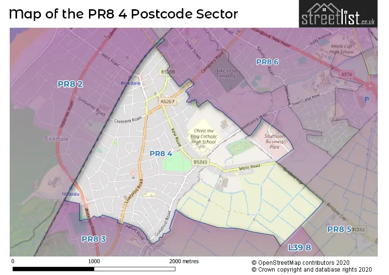
The PR8 4 Postcode shares a border with PR8 1 (SOUTHPORT), PR8 3 (SOUTHPORT, Ainsdale), PR8 2 (SOUTHPORT, Ainsdale, Birkdale), PR8 5 (SOUTHPORT, Scarisbrick) and L39 8 (Halsall, Shirdley Hill, ORMSKIRK).
The sector is within the post town of SOUTHPORT.
PR8 4 is a postcode sector within the PR8 postcode district which is within the PR Preston postcode area.
The Royal Mail delivery office for the PR8 4 postal sector is the Southport Delivery Office.
The area of the PR8 4 postcode sector is 1.56 square miles which is 4.05 square kilometres or 999.67 square acres.

Map of the PR8 4 Postcode Sector
Explore the PR8 4 postcode sector by using our free interactive map.
| P | R | 8 | - | 4 | X | X |
| P | R | 8 | Space | 4 | Letter | Letter |
Official List of Streets
SOUTHPORT (98 Streets)
Unofficial Streets or Alternative Spellings
SOUTHPORT
ALBERT TERRACE ARUNDEL ROAD AUGHTON ROAD CEMETERY ROAD FERNLEY ROAD GLENROSE TERRACE GROVE TERRACE HALSALL ROAD LYNTON ROAD MOSLEY STREET NAPIER TERRACE THE FALLOWS UPPER AUGHTON ROAD BIRKDALE COP BROOKSIDE ROAD CLAREMONT GARDENS FOOTBRIDGE LONDON LANE SAINT PETERS ROAD TOWN LANE (KEW) WALMER COURTAinsdale
LIVERPOOL ROADBirkdale
GROSVENOR ROADWeather Forecast for PR8 4
Press Button to Show Forecast for The Royal Birkdale Golf Club
| Time Period | Icon | Description | Temperature | Rain Probability | Wind |
|---|---|---|---|---|---|
| 06:00 to 09:00 | Cloudy | 9.0°C (feels like 5.0°C) | 9.00% | NW 20 mph | |
| 09:00 to 12:00 | Partly cloudy (day) | 9.0°C (feels like 6.0°C) | 1.00% | NW 22 mph | |
| 12:00 to 15:00 | Partly cloudy (day) | 10.0°C (feels like 7.0°C) | 2.00% | NW 20 mph | |
| 15:00 to 18:00 | Partly cloudy (day) | 11.0°C (feels like 7.0°C) | 1.00% | NW 18 mph | |
| 18:00 to 21:00 | Cloudy | 10.0°C (feels like 7.0°C) | 3.00% | NW 16 mph | |
| 21:00 to 00:00 | Cloudy | 9.0°C (feels like 7.0°C) | 3.00% | N 9 mph |
Press Button to Show Forecast for The Royal Birkdale Golf Club
| Time Period | Icon | Description | Temperature | Rain Probability | Wind |
|---|---|---|---|---|---|
| 00:00 to 03:00 | Cloudy | 6.0°C (feels like 5.0°C) | 3.00% | ENE 7 mph | |
| 03:00 to 06:00 | Cloudy | 5.0°C (feels like 4.0°C) | 4.00% | ENE 4 mph | |
| 06:00 to 09:00 | Partly cloudy (day) | 5.0°C (feels like 3.0°C) | 2.00% | ENE 4 mph | |
| 09:00 to 12:00 | Cloudy | 8.0°C (feels like 7.0°C) | 5.00% | NNE 4 mph | |
| 12:00 to 15:00 | Sunny day | 10.0°C (feels like 8.0°C) | 2.00% | NW 7 mph | |
| 15:00 to 18:00 | Partly cloudy (day) | 10.0°C (feels like 8.0°C) | 2.00% | NW 7 mph | |
| 18:00 to 21:00 | Partly cloudy (day) | 9.0°C (feels like 8.0°C) | 1.00% | NW 7 mph | |
| 21:00 to 00:00 | Partly cloudy (night) | 8.0°C (feels like 6.0°C) | 1.00% | NNW 7 mph |
Press Button to Show Forecast for The Royal Birkdale Golf Club
| Time Period | Icon | Description | Temperature | Rain Probability | Wind |
|---|---|---|---|---|---|
| 00:00 to 03:00 | Partly cloudy (night) | 7.0°C (feels like 6.0°C) | 2.00% | N 4 mph | |
| 03:00 to 06:00 | Partly cloudy (night) | 7.0°C (feels like 5.0°C) | 1.00% | NNE 4 mph | |
| 06:00 to 09:00 | Cloudy | 8.0°C (feels like 6.0°C) | 4.00% | NNW 4 mph | |
| 09:00 to 12:00 | Cloudy | 10.0°C (feels like 8.0°C) | 4.00% | NNE 7 mph | |
| 12:00 to 15:00 | Cloudy | 11.0°C (feels like 10.0°C) | 5.00% | NNW 7 mph | |
| 15:00 to 18:00 | Cloudy | 11.0°C (feels like 10.0°C) | 6.00% | N 7 mph | |
| 18:00 to 21:00 | Cloudy | 11.0°C (feels like 9.0°C) | 5.00% | NNE 7 mph | |
| 21:00 to 00:00 | Partly cloudy (night) | 9.0°C (feels like 7.0°C) | 2.00% | NE 7 mph |
Press Button to Show Forecast for The Royal Birkdale Golf Club
| Time Period | Icon | Description | Temperature | Rain Probability | Wind |
|---|---|---|---|---|---|
| 00:00 to 03:00 | Cloudy | 8.0°C (feels like 6.0°C) | 5.00% | ENE 7 mph | |
| 03:00 to 06:00 | Cloudy | 7.0°C (feels like 5.0°C) | 5.00% | E 7 mph | |
| 06:00 to 09:00 | Cloudy | 7.0°C (feels like 5.0°C) | 7.00% | E 7 mph | |
| 09:00 to 12:00 | Cloudy | 9.0°C (feels like 7.0°C) | 6.00% | ESE 7 mph | |
| 12:00 to 15:00 | Cloudy | 10.0°C (feels like 8.0°C) | 12.00% | ENE 7 mph | |
| 15:00 to 18:00 | Cloudy | 11.0°C (feels like 9.0°C) | 9.00% | NNE 7 mph | |
| 18:00 to 21:00 | Cloudy | 10.0°C (feels like 9.0°C) | 9.00% | NNE 7 mph | |
| 21:00 to 00:00 | Partly cloudy (night) | 9.0°C (feels like 7.0°C) | 3.00% | NE 7 mph |
Schools and Places of Education Within the PR8 4 Postcode Sector
Birkdale Primary School
Community school
Matlock Road, Southport, Merseyside, PR8 4EL
Head: Mr Nick Sheeran
Ofsted Rating: Good
Inspection: 2018-11-06 (1991 days ago)
Website: Visit Birkdale Primary School Website
Phone: 01704567516
Number of Pupils: 453
Christ The King Catholic High School and Sixth Form Centre
Voluntary aided school
Stamford Road, Southport, Merseyside, PR8 4EX
Head: Mrs Erin Wheeler
Ofsted Rating: Good
Inspection: 2023-11-30 (141 days ago)
Website: Visit Christ The King Catholic High School and Sixth Form Centre Website
Phone: 01704565121
Number of Pupils: 870
Our Lady of Lourdes Catholic Primary School
Voluntary aided school
Grantham Road, Southport, Merseyside, PR8 4LT
Head: Mr Darren McCann
Ofsted Rating: Good
Inspection: 2019-07-09 (1746 days ago)
Website: Visit Our Lady of Lourdes Catholic Primary School Website
Phone: 01704568375
Number of Pupils: 486
House Prices in the PR8 4 Postcode Sector
| Type of Property | 2018 Average | 2018 Sales | 2017 Average | 2017 Sales | 2016 Average | 2016 Sales | 2015 Average | 2015 Sales |
|---|---|---|---|---|---|---|---|---|
| Detached | £333,560 | 29 | £347,494 | 34 | £314,460 | 40 | £323,294 | 27 |
| Semi-Detached | £190,580 | 107 | £185,313 | 133 | £166,646 | 126 | £169,262 | 137 |
| Terraced | £162,900 | 16 | £130,058 | 13 | £138,275 | 10 | £129,235 | 23 |
| Flats | £112,857 | 14 | £110,778 | 18 | £128,208 | 12 | £101,333 | 12 |
Important Postcodes PR8 4 in the Postcode Sector
PR8 4BT is the postcode for St. Teresas Nursery & Infants School, Everton Road
PR8 4DB is the postcode for Family Surgery, 107 Liverpool Road
PR8 4EL is the postcode for Birkdale Primary School, Matlock Road, and BIRKDALE PRIMARY SCHOOL, MATLOCK ROAD
PR8 4EX is the postcode for SIXTH FORM BLOCK, Christ the King Catholic High School, Stamford Road, CHRIST THE KING RC HIGH & SIXTH FORM CTR SIXTH FORM BLOCK, Christ the King Catholic High School, Stamford Road, CHRIST THE KING RC HIGH & SIXTH FORM CTR MAIN BUILDING, GYM & SPORTS HALL, Christ the King Catholic High School, Stamford Road, MAIN BUILDING & SPORTS HALL, Christ the King Catholic High School, Stamford Road, C.D.T. BLOCK, Christ the King Catholic High School, Stamford Road, and CHRIST THE KING RC HIGH & SIXTH FORM CTR C.D.T. BLOCK, Christ the King Catholic High School, Stamford Road
PR8 4LT is the postcode for Our Lady of Lourdes School, Grantham Road
PR8 4PR is the postcode for Lincoln Road Clinic, Lincoln Road
PR8 4ZZ is the postcode for Royal Mail, Southport Delivery Office Southport Business Park, Wight Moss Way
| The PR8 4 Sector is within these Local Authorities |
|
|---|---|
| The PR8 4 Sector is within these Counties |
|
| The PR8 4 Sector is within these Water Company Areas |
|