The PR9 8 postcode sector stands on the Lancashire and Merseyside border.
Did you know? According to the 2021 Census, the PR9 8 postcode sector is home to a bustling 10,618 residents!
Given that each sector allows for 400 unique postcode combinations. Letters C, I, K, M, O and V are not allowed in the last two letters of a postcode. With 236 postcodes already in use, this leaves 164 units available.
The largest settlements in the PR9 8 postal code are SOUTHPORT and Banks.
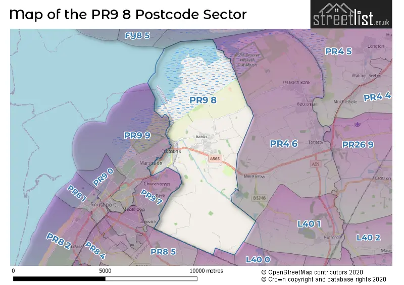
The PR9 8 Postcode shares a border with PR9 7 (SOUTHPORT, Churchtown), L40 1 (Rufford, Holmeswood), PR4 6 (Tarleton, Hesketh Bank, Mere Brow), PR8 5 (SOUTHPORT, Scarisbrick), PR9 9 (SOUTHPORT), L40 0 (Burscough) and L40 9 (Scarisbrick).
The sector is within the post town of SOUTHPORT.
PR9 8 is a postcode sector within the PR9 postcode district which is within the PR Preston postcode area.
The Royal Mail delivery office for the PR9 8 postal sector is the Southport Delivery Office.
The area of the PR9 8 postcode sector is 16.41 square miles which is 42.51 square kilometres or 10,505.59 square acres.
Waterways within the PR9 8 postcode sector include the Fine Jane's Brook, The Sluice.

Map of the PR9 8 Postcode Sector
Explore the PR9 8 postcode sector by using our free interactive map.
| P | R | 9 | - | 8 | X | X |
| P | R | 9 | Space | 8 | Letter | Letter |
Official List of Streets
Banks (50 Streets)
SOUTHPORT (90 Streets)
Scarisbrick (7 Streets)
Unofficial Streets or Alternative Spellings
SOUTHPORT
BANKFIELD LANE CLEVELEYS AVENUE CLEVELEYS ROAD FAIRHAVEN ROAD FYLDE ROAD GLENPARK DRIVE LONGACRE LYTHAM ROAD MARINE DRIVE PRIMROSE CLOSE SHELLFIELD ROAD VERULAM ROADHundred End
BOUNDARY LANE HUNDRED END LANE ALMOND BROW BROOK FARM BRIDGE BROOKVIEW CLOSE CABIN LANE CAUNCES ROAD CHERRY TREE CHESTNUT AVENUE DAISY CLOSE DOLLYS LANE FELLVIEW FERN END HAWTHORNE DRIVE HOLLY GROVE HONEYSUCKLE AVENUE JUNIPER WAY KERRY LANE MEADOW BROW MERE VIEW MIDGE HALL LANE NEW VALE OAK AVENUE OCEAN ROAD PARKWAY POPPY NOOK QUINCEY ROW RECREATION ROAD RIVERSIDE WALK RIVERSVIEW SAINT STEPHENS CLOSE SILVER BIRCH AVENUE SLACKEY LANE SUNFIELD VIEW THE BRAMBLES THE DRIVE THE PINES WHOLESOME LANE WILD ROSE WILLOW BANK WILLOW GROVEHesketh Bank
BOUNDARY MEANYGATE SHORE ROADScarisbrick
BESCAR LANE WYKE COP ROADWeather Forecast for PR9 8
Press Button to Show Forecast for Crossens
| Time Period | Icon | Description | Temperature | Rain Probability | Wind |
|---|---|---|---|---|---|
| 00:00 to 03:00 | Cloudy | 7.0°C (feels like 4.0°C) | 3.00% | WNW 11 mph | |
| 03:00 to 06:00 | Cloudy | 7.0°C (feels like 4.0°C) | 4.00% | WNW 11 mph | |
| 06:00 to 09:00 | Cloudy | 7.0°C (feels like 4.0°C) | 31.00% | NW 13 mph | |
| 09:00 to 12:00 | Partly cloudy (day) | 8.0°C (feels like 5.0°C) | 32.00% | NW 13 mph | |
| 12:00 to 15:00 | Cloudy | 10.0°C (feels like 7.0°C) | 5.00% | NW 11 mph | |
| 15:00 to 18:00 | Cloudy | 10.0°C (feels like 8.0°C) | 4.00% | NW 9 mph | |
| 18:00 to 21:00 | Cloudy | 8.0°C (feels like 7.0°C) | 37.00% | NE 4 mph | |
| 21:00 to 00:00 | Cloudy | 7.0°C (feels like 5.0°C) | 5.00% | ENE 7 mph |
Press Button to Show Forecast for Crossens
| Time Period | Icon | Description | Temperature | Rain Probability | Wind |
|---|---|---|---|---|---|
| 00:00 to 03:00 | Partly cloudy (night) | 5.0°C (feels like 2.0°C) | 4.00% | E 7 mph | |
| 03:00 to 06:00 | Clear night | 3.0°C (feels like 0.0°C) | 1.00% | ENE 7 mph | |
| 06:00 to 09:00 | Sunny day | 3.0°C (feels like 1.0°C) | 1.00% | ENE 7 mph | |
| 09:00 to 12:00 | Sunny day | 7.0°C (feels like 6.0°C) | 1.00% | ENE 4 mph | |
| 12:00 to 15:00 | Cloudy | 9.0°C (feels like 8.0°C) | 8.00% | NE 7 mph | |
| 15:00 to 18:00 | Light rain shower (day) | 10.0°C (feels like 9.0°C) | 28.00% | NE 4 mph | |
| 18:00 to 21:00 | Partly cloudy (day) | 9.0°C (feels like 8.0°C) | 3.00% | NNE 7 mph | |
| 21:00 to 00:00 | Cloudy | 6.0°C (feels like 3.0°C) | 6.00% | NE 7 mph |
Press Button to Show Forecast for Crossens
| Time Period | Icon | Description | Temperature | Rain Probability | Wind |
|---|---|---|---|---|---|
| 00:00 to 03:00 | Cloudy | 4.0°C (feels like 2.0°C) | 6.00% | E 7 mph | |
| 03:00 to 06:00 | Partly cloudy (night) | 3.0°C (feels like 0.0°C) | 5.00% | E 7 mph | |
| 06:00 to 09:00 | Partly cloudy (day) | 4.0°C (feels like 1.0°C) | 4.00% | E 7 mph | |
| 09:00 to 12:00 | Partly cloudy (day) | 8.0°C (feels like 6.0°C) | 5.00% | ESE 9 mph | |
| 12:00 to 15:00 | Overcast | 10.0°C (feels like 9.0°C) | 12.00% | E 7 mph | |
| 15:00 to 18:00 | Overcast | 11.0°C (feels like 9.0°C) | 16.00% | ENE 9 mph | |
| 18:00 to 21:00 | Cloudy | 10.0°C (feels like 8.0°C) | 10.00% | ENE 9 mph | |
| 21:00 to 00:00 | Partly cloudy (night) | 7.0°C (feels like 5.0°C) | 10.00% | NE 9 mph |
Press Button to Show Forecast for Crossens
| Time Period | Icon | Description | Temperature | Rain Probability | Wind |
|---|---|---|---|---|---|
| 00:00 to 03:00 | Cloudy | 6.0°C (feels like 3.0°C) | 15.00% | NE 9 mph | |
| 03:00 to 06:00 | Cloudy | 6.0°C (feels like 3.0°C) | 14.00% | NNE 9 mph | |
| 06:00 to 09:00 | Light rain | 7.0°C (feels like 3.0°C) | 48.00% | N 11 mph | |
| 09:00 to 12:00 | Light rain | 8.0°C (feels like 5.0°C) | 49.00% | N 11 mph | |
| 12:00 to 15:00 | Cloudy | 9.0°C (feels like 6.0°C) | 20.00% | N 11 mph | |
| 15:00 to 18:00 | Light rain | 10.0°C (feels like 7.0°C) | 51.00% | NNW 11 mph | |
| 18:00 to 21:00 | Partly cloudy (day) | 10.0°C (feels like 8.0°C) | 13.00% | NNW 11 mph | |
| 21:00 to 00:00 | Clear night | 8.0°C (feels like 5.0°C) | 9.00% | NW 9 mph |
Schools and Places of Education Within the PR9 8 Postcode Sector
Banks Methodist School
Voluntary controlled school
Chapel Lane, Southport, Merseyside, PR9 8EY
Head: Mr Stephen Draper
Ofsted Rating: Good
Inspection: 2021-07-14 (1016 days ago)
Website: Visit Banks Methodist School Website
Phone: 01704227323
Number of Pupils: 83
Banks St Stephen's CofE School
Voluntary controlled school
Greaves Hall Avenue, Southport, Merseyside, PR9 8BL
Head: Mr Gareth Allen
Ofsted Rating: Good
Inspection: 2021-09-15 (953 days ago)
Website: Visit Banks St Stephen's CofE School Website
Phone: 01704225332
Number of Pupils: 169
Crossens Nursery School
Local authority nursery school
Preston New Road, Southport, Merseyside, PR9 8PA
Head: Mrs Elizabeth (Beth) Brice
Ofsted Rating: Outstanding
Inspection: 2023-06-29 (301 days ago)
Website: Visit Crossens Nursery School Website
Phone: 01704228624
Number of Pupils: 66
Larkfield Primary School
Community school
Preston New Road, Southport, Merseyside, PR9 8PA
Head: Mr J D Ward
Ofsted Rating: Good
Inspection: 2023-06-15 (315 days ago)
Website: Visit Larkfield Primary School Website
Phone: 01704224720
Number of Pupils: 280
Peterhouse School
Non-maintained special school
Preston New Road, Southport, Merseyside, PR9 8PA
Head: Mr Calvin Wallace
Ofsted Rating: Requires improvement
Inspection: 2023-05-11 (350 days ago)
Website: Visit Peterhouse School Website
Phone: 01704506682
Number of Pupils: 72
Presfield High School and Specialist College
Community special school
Preston New Road, Southport, Merseyside, PR9 8PA
Head: Mrs Lucy McLoughlin
Ofsted Rating: Good
Inspection: 2023-09-27 (211 days ago)
Website: Visit Presfield High School and Specialist College Website
Phone: 01704227831
Number of Pupils: 123
St John's Church of England Primary School
Voluntary controlled school
Rufford Road, Southport, Merseyside, PR9 8JH
Head: Mr Phil Thomson
Ofsted Rating: Good
Inspection: 2022-05-12 (714 days ago)
Website: Visit St John's Church of England Primary School Website
Phone: 01704227441
Number of Pupils: 182
House Prices in the PR9 8 Postcode Sector
| Type of Property | 2018 Average | 2018 Sales | 2017 Average | 2017 Sales | 2016 Average | 2016 Sales | 2015 Average | 2015 Sales |
|---|---|---|---|---|---|---|---|---|
| Detached | £236,743 | 41 | £230,648 | 51 | £246,134 | 63 | £234,558 | 64 |
| Semi-Detached | £163,379 | 125 | £154,735 | 124 | £156,398 | 131 | £150,571 | 122 |
| Terraced | £118,660 | 15 | £145,731 | 13 | £134,311 | 9 | £126,300 | 19 |
| Flats | £93,818 | 11 | £88,828 | 16 | £77,975 | 6 | £103,132 | 11 |
Important Postcodes PR9 8 in the Postcode Sector
PR9 8BL is the postcode for Banks Leisure Centre, Greaves Hall Lane, St. Stephen C of E Primary School, Greaves Hall Lane, and Banks St Stephens C Of E Primary School, Greaves Hall Avenue
PR9 8ET is the postcode for NORTH MEOLS MEDICAL CENTRE, CHURCH ROAD, BANKS
PR9 8EY is the postcode for Banks Methodist Primary School, Chapel Lane
PR9 8JH is the postcode for St. Johns C of E Primary School, Rufford Road
PR9 8PA is the postcode for Presfield High School, Preston New Road, Peterhouse School, Preston New Road, Larkfield Cp School, Preston New Road, and Crossens Nursery School, Preston New Road
| The PR9 8 Sector is within these Local Authorities |
|
|---|---|
| The PR9 8 Sector is within these Counties |
|
| The PR9 8 Sector is within these Water Company Areas |
|