The RG14 2 postcode sector is within the county of Berkshire.
Did you know? According to the 2021 Census, the RG14 2 postcode sector is home to a bustling 8,608 residents!
Given that each sector allows for 400 unique postcode combinations. Letters C, I, K, M, O and V are not allowed in the last two letters of a postcode. With 221 postcodes already in use, this leaves 179 units available.
The largest settlement in the RG14 2 postal code is NEWBURY followed by Shaw, and Donnington.
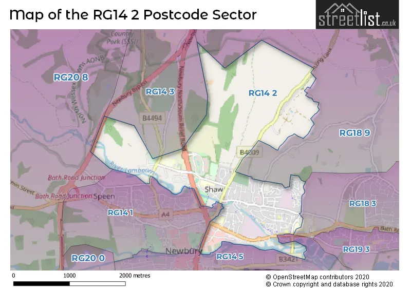
The RG14 2 Postcode shares a border with RG14 5 (NEWBURY), RG14 1 (NEWBURY, Speen), RG18 3 (THATCHAM, Cold Ash, Benham Hill), RG18 9 (Hermitage, Cold Ash, Curridge), RG14 3 (Donnington, Snelsmore Common, Snelsmore) and RG20 8 (Chieveley, Beedon, Stockcross).
The sector is within the post town of NEWBURY.
RG14 2 is a postcode sector within the RG14 postcode district which is within the RG Reading postcode area.
The Royal Mail delivery office for the RG14 2 postal sector is the Newbury Delivery Office.
The area of the RG14 2 postcode sector is 2.73 square miles which is 7.08 square kilometres or 1,748.47 square acres.
The RG14 2 postcode sector is crossed by the A34 Major A road.
Waterways within the RG14 2 postcode sector include the Kennet & Avon Canal.

Map of the RG14 2 Postcode Sector
Explore the RG14 2 postcode sector by using our free interactive map.
| R | G | 1 | 4 | - | 2 | X | X |
| R | G | 1 | 4 | Space | 2 | Letter | Letter |
Official List of Streets
Donnington (10 Streets)
NEWBURY (92 Streets)
Shaw (21 Streets)
Unofficial Streets or Alternative Spellings
Henwick
MANOR LANENEWBURY
SHAW ROAD TWO RIVERS WAY WESTERN AVENUE AVONWAY BROOKVALE COURT CRAVEN DENE ELY CLOSE GLEBEFIELDS HUNTINGTON GARDENS LAMP ACRES LOCKETTS BRIDGE MARCONI ROAD NEWBURY BYPASS NEWBURY NORTH/SOUTH RELIEF ROAD PINDER PLACE RIVER PARK SHOP LANE SKYLINGS ST RICHARDS ROAD STABLE COURT WALLER DRIVE YEW GATEBenham Hill
LONDON ROADAshmore Green
STONEY LANECold Ash
LONG LANEChieveley
OXFORD ROADWeather Forecast for RG14 2
Press Button to Show Forecast for Newbury
| Time Period | Icon | Description | Temperature | Rain Probability | Wind |
|---|---|---|---|---|---|
| 00:00 to 03:00 | Cloudy | 6.0°C (feels like 4.0°C) | 5.00% | ENE 7 mph | |
| 03:00 to 06:00 | Cloudy | 5.0°C (feels like 2.0°C) | 5.00% | ENE 7 mph | |
| 06:00 to 09:00 | Cloudy | 4.0°C (feels like 2.0°C) | 6.00% | ENE 7 mph | |
| 09:00 to 12:00 | Cloudy | 7.0°C (feels like 5.0°C) | 6.00% | ENE 9 mph | |
| 12:00 to 15:00 | Cloudy | 10.0°C (feels like 8.0°C) | 13.00% | ENE 7 mph | |
| 15:00 to 18:00 | Overcast | 10.0°C (feels like 9.0°C) | 16.00% | ENE 4 mph | |
| 18:00 to 21:00 | Cloudy | 9.0°C (feels like 8.0°C) | 12.00% | ENE 4 mph | |
| 21:00 to 00:00 | Cloudy | 6.0°C (feels like 4.0°C) | 11.00% | ENE 7 mph |
Press Button to Show Forecast for Newbury
| Time Period | Icon | Description | Temperature | Rain Probability | Wind |
|---|---|---|---|---|---|
| 00:00 to 03:00 | Cloudy | 5.0°C (feels like 3.0°C) | 14.00% | ENE 7 mph | |
| 03:00 to 06:00 | Cloudy | 4.0°C (feels like 2.0°C) | 18.00% | ENE 7 mph | |
| 06:00 to 09:00 | Light rain | 5.0°C (feels like 2.0°C) | 53.00% | NE 7 mph | |
| 09:00 to 12:00 | Overcast | 8.0°C (feels like 5.0°C) | 23.00% | ENE 9 mph | |
| 12:00 to 15:00 | Overcast | 11.0°C (feels like 9.0°C) | 19.00% | ENE 11 mph | |
| 15:00 to 18:00 | Overcast | 12.0°C (feels like 9.0°C) | 22.00% | ENE 11 mph | |
| 18:00 to 21:00 | Light rain | 10.0°C (feels like 8.0°C) | 53.00% | ENE 9 mph | |
| 21:00 to 00:00 | Light rain | 8.0°C (feels like 6.0°C) | 51.00% | NE 11 mph |
Press Button to Show Forecast for Newbury
| Time Period | Icon | Description | Temperature | Rain Probability | Wind |
|---|---|---|---|---|---|
| 00:00 to 03:00 | Heavy rain | 8.0°C (feels like 5.0°C) | 77.00% | NE 11 mph | |
| 03:00 to 06:00 | Heavy rain | 7.0°C (feels like 5.0°C) | 78.00% | NE 9 mph | |
| 06:00 to 09:00 | Light rain | 8.0°C (feels like 6.0°C) | 55.00% | NE 7 mph | |
| 09:00 to 12:00 | Light rain shower (day) | 10.0°C (feels like 8.0°C) | 40.00% | SE 7 mph | |
| 12:00 to 15:00 | Light rain shower (day) | 11.0°C (feels like 9.0°C) | 41.00% | SSW 11 mph | |
| 15:00 to 18:00 | Light rain shower (day) | 11.0°C (feels like 8.0°C) | 41.00% | W 11 mph | |
| 18:00 to 21:00 | Light rain shower (day) | 10.0°C (feels like 8.0°C) | 35.00% | W 9 mph | |
| 21:00 to 00:00 | Cloudy | 8.0°C (feels like 6.0°C) | 9.00% | W 7 mph |
Schools and Places of Education Within the RG14 2 Postcode Sector
Engaging Potential
Other independent special school
Progress House, Newbury, , RG14 2PR
Head: Mrs Tracy Parker
Ofsted Rating: Good
Inspection: 2021-11-11 (897 days ago)
Website: Visit Engaging Potential Website
Phone: 01635524113
Number of Pupils: 12
Fir Tree Primary School and Nursery
Academy sponsor led
Fir Tree Lane, Newbury, Berkshire, RG14 2RA
Head: Mrs Lindsay Wood
Ofsted Rating: Good
Inspection: 2022-05-12 (715 days ago)
Website: Visit Fir Tree Primary School and Nursery Website
Phone: 0163542129
Number of Pupils: 231
Shaw-cum-Donnington C.E. Primary School
Voluntary controlled school
Love Lane, Newbury, Berkshire, RG14 2JG
Head: Ms Lindsay Wakefield
Ofsted Rating: Requires improvement
Inspection: 2022-10-12 (562 days ago)
Website: Visit Shaw-cum-Donnington C.E. Primary School Website
Phone: 0163540971
Number of Pupils: 90
St Joseph's Catholic Primary School
Voluntary aided school
Newport Road, Newbury, Berkshire, RG14 2AW
Head: Mrs Kelly Bosher
Ofsted Rating: Good
Inspection: 2023-10-18 (191 days ago)
Website: Visit St Joseph's Catholic Primary School Website
Phone: 0163543455
Number of Pupils: 235
The Castle School
Community special school
Love Lane, Newbury, Berkshire, RG14 2JG
Head: Mr Jon Hewitt
Ofsted Rating: Outstanding
Inspection: 2019-01-15 (1928 days ago)
Website: Visit The Castle School Website
Phone: 0163542976
Number of Pupils: 175
Trinity School
Academy converter
Love Lane, Newbury, Berkshire, RG14 2DU
Head: Dr Charlotte Wilson
Ofsted Rating: Good
Inspection: 2018-07-04 (2123 days ago)
Website: Visit Trinity School Website
Phone: 01635510500
Number of Pupils: 1234
House Prices in the RG14 2 Postcode Sector
| Type of Property | 2018 Average | 2018 Sales | 2017 Average | 2017 Sales | 2016 Average | 2016 Sales | 2015 Average | 2015 Sales |
|---|---|---|---|---|---|---|---|---|
| Detached | £547,780 | 23 | £455,025 | 34 | £449,548 | 30 | £431,811 | 32 |
| Semi-Detached | £322,410 | 31 | £324,376 | 51 | £300,597 | 38 | £282,225 | 48 |
| Terraced | £270,413 | 42 | £263,918 | 38 | £279,111 | 45 | £246,189 | 32 |
| Flats | £193,161 | 23 | £185,823 | 26 | £199,334 | 48 | £170,953 | 31 |
Important Postcodes RG14 2 in the Postcode Sector
RG14 2AF is the postcode for West Berkshire District Council, Council Offices, Faraday Road
RG14 2AW is the postcode for St. Josephs RC Primary School, Newport Road
RG14 2DR is the postcode for Registrar of Births Deaths & Marriages, Shaw House, Church Road
RG14 2DU is the postcode for Sports Centre, Trinity School & Performing Arts College, BLOCK B, Trinity School & Performing Arts College, Love Lane, BLOCK A, Trinity School & Performing Arts College, Love Lane, BLOCKS A & G, Trinity School & Performing Arts College, Love Lane, SPORTS CENTRE, Trinity School & Performing Arts College, Love Lane, and BLOCK I, Trinity School & Performing Arts College, Love Lane
RG14 2FG is the postcode for Riverside Community Centre, Rosemoor Gardens
RG14 2JG is the postcode for The Castle Gate, Love Lane, PRIMARY SCHOOL BLOCK, Castle School, Love Lane, and SECONDARY SCHOOL BLOCK, Castle School, Love Lane
RG14 2PZ is the postcode for South Central Strategic Health Authority, Rivergate House, Newbury Business Park, London Road
RG14 2RA is the postcode for FIR TREE PRIMARY SCHOOL AND NURSERY, FIR TREE LANE, NEWBURY, Fir Tree School, Fir Tree Lane, Berkshire, Fir Tree Cp School, Fir Tree Lane, and Fir Tree Primary School And Nursery, Fir Tree Lane
| The RG14 2 Sector is within these Local Authorities |
|
|---|---|
| The RG14 2 Sector is within these Counties |
|
| The RG14 2 Sector is within these Water Company Areas |
|