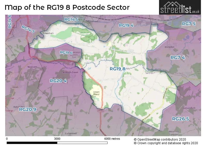
The RG19 8 postcode sector stands on the Berkshire and Hampshire border.
Did you know? According to the 2021 Census, the RG19 8 postcode sector is home to a bustling 3,775 residents!
Given that each sector allows for 400 unique postcode combinations. Letters C, I, K, M, O and V are not allowed in the last two letters of a postcode. With 148 postcodes already in use, this leaves 252 units available.
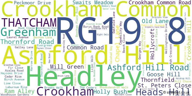
The largest settlement in the RG19 8 postal code is Greenham followed by Headley, and Crookham Common.
The RG19 8 Postcode shares a border with RG14 5 (NEWBURY), RG14 7 (NEWBURY), RG19 3 (THATCHAM), RG19 4 (THATCHAM), RG20 4 (Bishops Green, Kingsclere, Ecchinswell), RG7 4 (Aldermaston, Theale, Sulhamstead), RG7 5 (Theale, Beenham, Woolhampton), RG20 9 (Woolton Hill, Highclere, Burghclere) and RG26 5 (Bramley, Baughurst, Little London).
The sector is within the post town of THATCHAM.
RG19 8 is a postcode sector within the RG19 postcode district which is within the RG Reading postcode area.
The Royal Mail delivery office for the RG19 8 postal sector is the Thatcham Delivery Office.
The area of the RG19 8 postcode sector is 10.32 square miles which is 26.73 square kilometres or 6,604.67 square acres.
Waterways within the RG19 8 postcode sector include the River Enborne.

Map of the RG19 8 Postcode Sector
Explore the RG19 8 postcode sector by using our free interactive map.
| R | G | 1 | 9 | - | 8 | X | X |
| R | G | 1 | 9 | Space | 8 | Letter | Letter |
Official List of Streets
Crookham Common (19 Streets)
Ashford Hill (8 Streets)
Headley (23 Streets)
Greenham (28 Streets)
Crookham (1 Streets)
Unofficial Streets or Alternative Spellings
Brimpton
BRIMPTON ROAD CROOKHAM COMMON ROADKingsclere
UNION LANENEWBURY
GREENHAM ROAD THE TRIANGLEWeather Forecast for RG19 8
Press Button to Show Forecast for Thatcham
| Time Period | Icon | Description | Temperature | Rain Probability | Wind |
|---|---|---|---|---|---|
| 15:00 to 18:00 | Cloudy | 10.0°C (feels like 8.0°C) | 10.00% | W 9 mph | |
| 18:00 to 21:00 | Cloudy | 9.0°C (feels like 7.0°C) | 9.00% | N 7 mph | |
| 21:00 to 00:00 | Cloudy | 7.0°C (feels like 5.0°C) | 9.00% | NE 4 mph |
Press Button to Show Forecast for Thatcham
| Time Period | Icon | Description | Temperature | Rain Probability | Wind |
|---|---|---|---|---|---|
| 00:00 to 03:00 | Cloudy | 6.0°C (feels like 4.0°C) | 5.00% | ENE 7 mph | |
| 03:00 to 06:00 | Cloudy | 5.0°C (feels like 2.0°C) | 5.00% | NE 7 mph | |
| 06:00 to 09:00 | Cloudy | 4.0°C (feels like 2.0°C) | 6.00% | ENE 7 mph | |
| 09:00 to 12:00 | Cloudy | 7.0°C (feels like 5.0°C) | 6.00% | ENE 9 mph | |
| 12:00 to 15:00 | Overcast | 10.0°C (feels like 8.0°C) | 13.00% | ENE 7 mph | |
| 15:00 to 18:00 | Overcast | 10.0°C (feels like 9.0°C) | 16.00% | ENE 4 mph | |
| 18:00 to 21:00 | Cloudy | 9.0°C (feels like 8.0°C) | 12.00% | ENE 4 mph | |
| 21:00 to 00:00 | Cloudy | 6.0°C (feels like 4.0°C) | 11.00% | ENE 7 mph |
Press Button to Show Forecast for Thatcham
| Time Period | Icon | Description | Temperature | Rain Probability | Wind |
|---|---|---|---|---|---|
| 00:00 to 03:00 | Cloudy | 5.0°C (feels like 3.0°C) | 15.00% | ENE 7 mph | |
| 03:00 to 06:00 | Cloudy | 4.0°C (feels like 2.0°C) | 20.00% | ENE 7 mph | |
| 06:00 to 09:00 | Light rain | 5.0°C (feels like 2.0°C) | 53.00% | NE 7 mph | |
| 09:00 to 12:00 | Cloudy | 8.0°C (feels like 5.0°C) | 20.00% | ENE 9 mph | |
| 12:00 to 15:00 | Overcast | 11.0°C (feels like 9.0°C) | 19.00% | ENE 9 mph | |
| 15:00 to 18:00 | Light rain | 12.0°C (feels like 9.0°C) | 49.00% | ENE 11 mph | |
| 18:00 to 21:00 | Light rain | 10.0°C (feels like 8.0°C) | 53.00% | ENE 9 mph | |
| 21:00 to 00:00 | Light rain | 8.0°C (feels like 6.0°C) | 51.00% | NE 11 mph |
Press Button to Show Forecast for Thatcham
| Time Period | Icon | Description | Temperature | Rain Probability | Wind |
|---|---|---|---|---|---|
| 00:00 to 03:00 | Heavy rain | 8.0°C (feels like 5.0°C) | 77.00% | NE 11 mph | |
| 03:00 to 06:00 | Heavy rain | 7.0°C (feels like 5.0°C) | 78.00% | NE 9 mph | |
| 06:00 to 09:00 | Light rain | 8.0°C (feels like 6.0°C) | 55.00% | NE 7 mph | |
| 09:00 to 12:00 | Light rain shower (day) | 10.0°C (feels like 8.0°C) | 40.00% | SE 7 mph | |
| 12:00 to 15:00 | Light rain shower (day) | 11.0°C (feels like 9.0°C) | 39.00% | SSW 11 mph | |
| 15:00 to 18:00 | Light rain shower (day) | 11.0°C (feels like 8.0°C) | 39.00% | W 11 mph | |
| 18:00 to 21:00 | Cloudy | 10.0°C (feels like 8.0°C) | 16.00% | W 9 mph | |
| 21:00 to 00:00 | Cloudy | 8.0°C (feels like 6.0°C) | 10.00% | W 7 mph |
House Prices in the RG19 8 Postcode Sector
| Type of Property | 2018 Average | 2018 Sales | 2017 Average | 2017 Sales | 2016 Average | 2016 Sales | 2015 Average | 2015 Sales |
|---|---|---|---|---|---|---|---|---|
| Detached | £738,563 | 24 | £647,978 | 23 | £625,762 | 21 | £469,351 | 37 |
| Semi-Detached | £433,306 | 8 | £380,500 | 9 | £402,550 | 9 | £383,142 | 12 |
| Terraced | £281,650 | 3 | £308,750 | 6 | £348,125 | 8 | £338,746 | 12 |
| Flats | £0 | 0 | £0 | 0 | £0 | 0 | £0 | 0 |
Important Postcodes RG19 8 in the Postcode Sector
RG19 8BB is the postcode for Ashford Hill Primary School, Ashford Hill Road
| The RG19 8 Sector is within these Local Authorities |
|
|---|---|
| The RG19 8 Sector is within these Counties |
|
| The RG19 8 Sector is within these Water Company Areas |
|