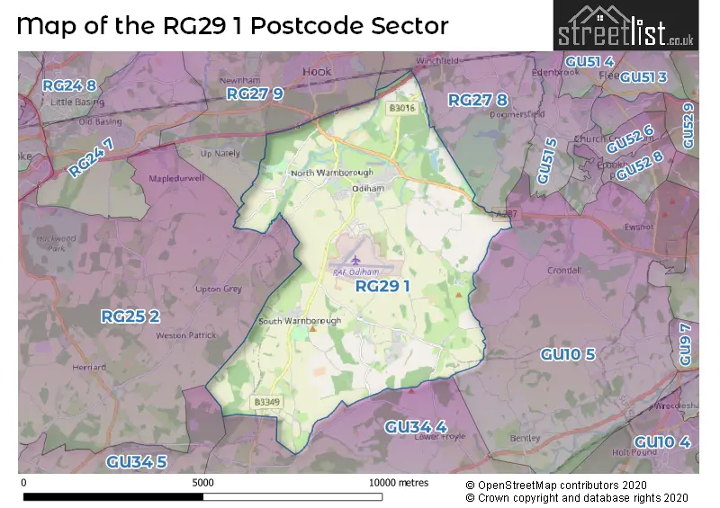
The RG29 1 postcode sector is within the county of Hampshire.
Did you know? According to the 2021 Census, the RG29 1 postcode sector is home to a bustling 7,064 residents!
Given that each sector allows for 400 unique postcode combinations. Letters C, I, K, M, O and V are not allowed in the last two letters of a postcode. With 270 postcodes already in use, this leaves 130 units available.
The largest settlement in the RG29 1 postal code is Odiham followed by North Warnborough, and South Warnborough.
The RG29 1 Postcode shares a border with GU10 5 (Crondall, Bentley, Ewshot), GU34 4 (Holybourne, Beech, Upper Froyle), GU34 5 (Four Marks, Medstead, Bentworth), RG25 2 (North Waltham, Upton Grey, Cliddesden), RG27 8 (Hartley Wintney, Winchfield, Dogmersfield) and RG27 9 (HOOK, Rotherwick, Newnham).
The sector is within the post town of HOOK.
RG29 1 is a postcode sector within the RG25 postcode district which is within the RG Reading postcode area.
The Royal Mail delivery office for the RG29 1 postal sector is the unknown.
The area of the RG29 1 postcode sector is 19.26 square miles which is 49.88 square kilometres or 12,324.50 square acres.
The RG29 1 postcode sector is crossed by the M3 motorway.
Waterways within the RG29 1 postcode sector include the Basingstoke Canal.

Map of the RG29 1 Postcode Sector
Explore the RG29 1 postcode sector by using our free interactive map.
| R | G | 2 | 9 | - | 1 | X | X |
| R | G | 2 | 9 | Space | 1 | Letter | Letter |
Official List of Streets
North Warnborough (26 Streets)
Odiham (76 Streets)
South Warnborough (14 Streets)
Long Sutton (11 Streets)
Unofficial Streets or Alternative Spellings
Crondall
FARNHAM ROAD WELL ROADOdiham
FULBROOK WAY MILDMAY COURTDogmersfield
CHALKY LANELower Froyle
WELL LANEUpton Grey
BIDDEN ROAD FORD LANEHartley Wintney
TOTTERS LANEMapledurwell
GREYWELL ROADWeather Forecast for RG29 1
Press Button to Show Forecast for Odiham
| Time Period | Icon | Description | Temperature | Rain Probability | Wind |
|---|---|---|---|---|---|
| 15:00 to 18:00 | Light rain | 11.0°C (feels like 9.0°C) | 51.00% | W 9 mph | |
| 18:00 to 21:00 | Cloudy | 9.0°C (feels like 8.0°C) | 10.00% | NW 9 mph | |
| 21:00 to 00:00 | Cloudy | 7.0°C (feels like 6.0°C) | 10.00% | NE 4 mph |
Press Button to Show Forecast for Odiham
| Time Period | Icon | Description | Temperature | Rain Probability | Wind |
|---|---|---|---|---|---|
| 00:00 to 03:00 | Cloudy | 6.0°C (feels like 4.0°C) | 8.00% | ENE 7 mph | |
| 03:00 to 06:00 | Cloudy | 6.0°C (feels like 3.0°C) | 6.00% | ENE 7 mph | |
| 06:00 to 09:00 | Cloudy | 5.0°C (feels like 2.0°C) | 7.00% | ENE 9 mph | |
| 09:00 to 12:00 | Cloudy | 7.0°C (feels like 4.0°C) | 8.00% | ENE 9 mph | |
| 12:00 to 15:00 | Overcast | 10.0°C (feels like 8.0°C) | 15.00% | ENE 9 mph | |
| 15:00 to 18:00 | Overcast | 11.0°C (feels like 9.0°C) | 18.00% | ENE 7 mph | |
| 18:00 to 21:00 | Cloudy | 10.0°C (feels like 9.0°C) | 12.00% | ENE 7 mph | |
| 21:00 to 00:00 | Cloudy | 7.0°C (feels like 5.0°C) | 11.00% | ENE 7 mph |
Press Button to Show Forecast for Odiham
| Time Period | Icon | Description | Temperature | Rain Probability | Wind |
|---|---|---|---|---|---|
| 00:00 to 03:00 | Cloudy | 6.0°C (feels like 3.0°C) | 15.00% | ENE 7 mph | |
| 03:00 to 06:00 | Light rain | 5.0°C (feels like 3.0°C) | 51.00% | ENE 7 mph | |
| 06:00 to 09:00 | Light rain | 5.0°C (feels like 3.0°C) | 48.00% | NE 9 mph | |
| 09:00 to 12:00 | Overcast | 8.0°C (feels like 6.0°C) | 20.00% | ENE 11 mph | |
| 12:00 to 15:00 | Overcast | 11.0°C (feels like 9.0°C) | 19.00% | ENE 11 mph | |
| 15:00 to 18:00 | Light rain shower (day) | 12.0°C (feels like 10.0°C) | 38.00% | ENE 11 mph | |
| 18:00 to 21:00 | Light rain | 11.0°C (feels like 8.0°C) | 54.00% | ENE 11 mph | |
| 21:00 to 00:00 | Light rain | 9.0°C (feels like 6.0°C) | 52.00% | ENE 13 mph |
Press Button to Show Forecast for Odiham
| Time Period | Icon | Description | Temperature | Rain Probability | Wind |
|---|---|---|---|---|---|
| 00:00 to 03:00 | Heavy rain | 8.0°C (feels like 6.0°C) | 73.00% | NE 11 mph | |
| 03:00 to 06:00 | Heavy rain | 8.0°C (feels like 6.0°C) | 76.00% | NE 9 mph | |
| 06:00 to 09:00 | Light rain | 9.0°C (feels like 7.0°C) | 52.00% | ESE 9 mph | |
| 09:00 to 12:00 | Heavy rain shower (day) | 10.0°C (feels like 8.0°C) | 61.00% | ESE 9 mph | |
| 12:00 to 15:00 | Light rain shower (day) | 12.0°C (feels like 10.0°C) | 42.00% | SW 11 mph | |
| 15:00 to 18:00 | Light rain shower (day) | 12.0°C (feels like 10.0°C) | 41.00% | WSW 13 mph | |
| 18:00 to 21:00 | Cloudy | 11.0°C (feels like 9.0°C) | 12.00% | W 11 mph | |
| 21:00 to 00:00 | Partly cloudy (night) | 9.0°C (feels like 7.0°C) | 6.00% | WSW 7 mph |
Schools and Places of Education Within the RG29 1 Postcode Sector
Buryfields Infant School
Community school
Buryfields, Hook, Hampshire, RG29 1NE
Head: Miss Lauren English
Ofsted Rating: Good
Inspection: 2019-06-06 (1785 days ago)
Website: Visit Buryfields Infant School Website
Phone: 01256702667
Number of Pupils: 180
Long Sutton Church of England Primary School
Voluntary controlled school
Hyde Road, Hook, Hampshire, RG29 1ST
Head: Mrs Selena Cameron
Ofsted Rating: Good
Inspection: 2023-09-20 (218 days ago)
Website: Visit Long Sutton Church of England Primary School Website
Phone: 01256862238
Number of Pupils: 100
Mayhill Junior School
Community school
The Bury, Hook, Hampshire, RG29 1NB
Head: Mrs Sarah McGillivray
Ofsted Rating: Good
Inspection: 2019-12-04 (1604 days ago)
Website: Visit Mayhill Junior School Website
Phone: 01256702973
Number of Pupils: 241
Robert May's School
Academy converter
West Street, Hook, Hampshire, RG29 1NA
Head: Mrs Rea Mitchell
Ofsted Rating: Good
Inspection: 2022-11-23 (519 days ago)
Website: Visit Robert May's School Website
Phone: 01256702700
Number of Pupils: 1317
House Prices in the RG29 1 Postcode Sector
| Type of Property | 2018 Average | 2018 Sales | 2017 Average | 2017 Sales | 2016 Average | 2016 Sales | 2015 Average | 2015 Sales |
|---|---|---|---|---|---|---|---|---|
| Detached | £789,965 | 55 | £728,564 | 44 | £702,925 | 48 | £655,137 | 30 |
| Semi-Detached | £432,535 | 24 | £494,535 | 23 | £420,519 | 27 | £477,567 | 21 |
| Terraced | £404,340 | 23 | £355,547 | 17 | £386,598 | 24 | £416,309 | 16 |
| Flats | £261,050 | 9 | £163,408 | 6 | £217,000 | 5 | £198,328 | 9 |
Important Postcodes RG29 1 in the Postcode Sector
RG29 1JY is the postcode for The Odiham Health Centre, Deer Park View
RG29 1NA is the postcode for MATHS BLOCK, Robert Mays School, West Street, MAIN BUILDING AND SPORTSHALL, Robert Mays School, West Street, ENGLISH BLOCK, Robert Mays School, West Street, NEW BUILDING INVICTUS BUILDING, Robert Mays School, West Street, Robert Mays School, West Street, PRACTICAL BLOCK, Robert Mays School, West Street, and MUSIC BLOCK, Robert Mays School, West Street
RG29 1NB is the postcode for Mayhill County Junior School, The Bury, Odiham, and Mayhill County Junior School, The Bury
RG29 1NE is the postcode for Buryfields Infant School, Buryfields, and Buryfields Infant School, Buryfields, Odiham
RG29 1ST is the postcode for Longsutton C of E Primary School, The Street
| The RG29 1 Sector is within these Local Authorities |
|
|---|---|
| The RG29 1 Sector is within these Counties |
|
| The RG29 1 Sector is within these Water Company Areas |
|
Tourist Attractions within the RG29 1 Postcode Area
We found 1 visitor attractions within the RG25 postcode area
| Galleon Marine |
|---|
| Leisure / Theme Parks |
| Leisure / Theme Park |
| View Galleon Marine on Google Maps |