The RH10 5 postcode sector is within the county of West Sussex.
Did you know? According to the 2021 Census, the RH10 5 postcode sector is home to a bustling 6,521 residents!
Given that each sector allows for 400 unique postcode combinations. Letters C, I, K, M, O and V are not allowed in the last two letters of a postcode. With 138 postcodes already in use, this leaves 262 units available.
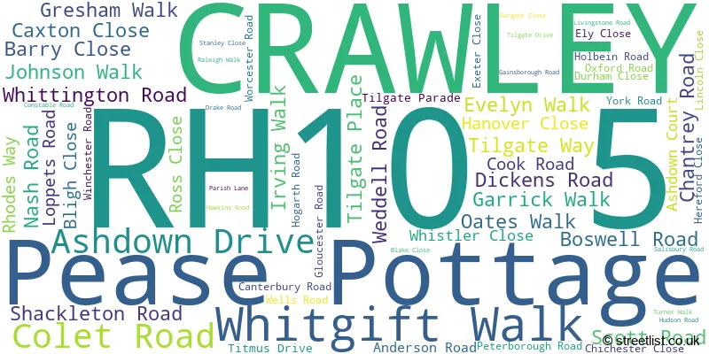
The largest settlements in the RH10 5 postal code are CRAWLEY and Pease Pottage.
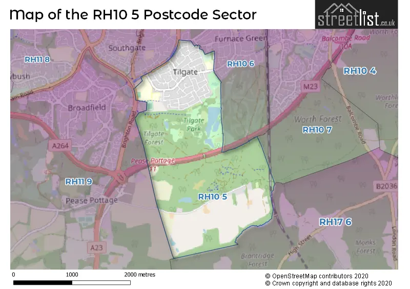
The RH10 5 Postcode shares a border with RH10 7 (Maidenbower, CRAWLEY, Worth), RH11 9 (CRAWLEY, Pease Pottage, Broadfield), RH10 6 (CRAWLEY) and RH17 6 (Balcombe, Ardingly, Handcross).
The sector is within the post town of CRAWLEY.
RH10 5 is a postcode sector within the RH10 postcode district which is within the RH Redhill postcode area.
The Royal Mail delivery office for the RH10 5 postal sector is the Crawley Delivery Office.
The area of the RH10 5 postcode sector is 2.09 square miles which is 5.41 square kilometres or 1,336.98 square acres.
The RH10 5 postcode sector is crossed by the M23 motorway.

Map of the RH10 5 Postcode Sector
Explore the RH10 5 postcode sector by using our free interactive map.
| R | H | 1 | 0 | - | 5 | X | X |
| R | H | 1 | 0 | Space | 5 | Letter | Letter |
Official List of Streets
CRAWLEY (60 Streets)
Pease Pottage (1 Streets)
Unofficial Streets or Alternative Spellings
Weather Forecast for RH10 5
Press Button to Show Forecast for Crawley
| Time Period | Icon | Description | Temperature | Rain Probability | Wind |
|---|---|---|---|---|---|
| 18:00 to 21:00 | Cloudy | 9.0°C (feels like 6.0°C) | 16.00% | N 11 mph | |
| 21:00 to 00:00 | Cloudy | 8.0°C (feels like 6.0°C) | 5.00% | N 7 mph |
Press Button to Show Forecast for Crawley
| Time Period | Icon | Description | Temperature | Rain Probability | Wind |
|---|---|---|---|---|---|
| 00:00 to 03:00 | Clear night | 5.0°C (feels like 3.0°C) | 0.00% | NW 7 mph | |
| 03:00 to 06:00 | Cloudy | 5.0°C (feels like 2.0°C) | 4.00% | NNW 7 mph | |
| 06:00 to 09:00 | Cloudy | 5.0°C (feels like 2.0°C) | 4.00% | NNW 9 mph | |
| 09:00 to 12:00 | Cloudy | 7.0°C (feels like 4.0°C) | 4.00% | NNW 11 mph | |
| 12:00 to 15:00 | Cloudy | 9.0°C (feels like 7.0°C) | 4.00% | NNW 11 mph | |
| 15:00 to 18:00 | Cloudy | 10.0°C (feels like 8.0°C) | 3.00% | NNW 11 mph | |
| 18:00 to 21:00 | Cloudy | 9.0°C (feels like 8.0°C) | 4.00% | NNW 7 mph | |
| 21:00 to 00:00 | Partly cloudy (night) | 6.0°C (feels like 5.0°C) | 1.00% | NE 4 mph |
Press Button to Show Forecast for Crawley
| Time Period | Icon | Description | Temperature | Rain Probability | Wind |
|---|---|---|---|---|---|
| 00:00 to 03:00 | Cloudy | 5.0°C (feels like 4.0°C) | 4.00% | SE 4 mph | |
| 03:00 to 06:00 | Cloudy | 5.0°C (feels like 3.0°C) | 4.00% | SW 4 mph | |
| 06:00 to 09:00 | Cloudy | 5.0°C (feels like 4.0°C) | 5.00% | SW 4 mph | |
| 09:00 to 12:00 | Cloudy | 9.0°C (feels like 7.0°C) | 6.00% | W 7 mph | |
| 12:00 to 15:00 | Cloudy | 11.0°C (feels like 9.0°C) | 8.00% | W 9 mph | |
| 15:00 to 18:00 | Cloudy | 11.0°C (feels like 9.0°C) | 9.00% | W 11 mph | |
| 18:00 to 21:00 | Cloudy | 10.0°C (feels like 9.0°C) | 8.00% | W 7 mph | |
| 21:00 to 00:00 | Cloudy | 8.0°C (feels like 7.0°C) | 5.00% | NW 4 mph |
Press Button to Show Forecast for Crawley
| Time Period | Icon | Description | Temperature | Rain Probability | Wind |
|---|---|---|---|---|---|
| 00:00 to 03:00 | Cloudy | 7.0°C (feels like 5.0°C) | 8.00% | ENE 4 mph | |
| 03:00 to 06:00 | Cloudy | 6.0°C (feels like 4.0°C) | 5.00% | ENE 4 mph | |
| 06:00 to 09:00 | Cloudy | 6.0°C (feels like 4.0°C) | 8.00% | E 7 mph | |
| 09:00 to 12:00 | Cloudy | 9.0°C (feels like 7.0°C) | 8.00% | ESE 7 mph | |
| 12:00 to 15:00 | Light rain shower (day) | 10.0°C (feels like 8.0°C) | 41.00% | SSE 9 mph | |
| 15:00 to 18:00 | Cloudy | 11.0°C (feels like 9.0°C) | 13.00% | SSE 9 mph | |
| 18:00 to 21:00 | Cloudy | 10.0°C (feels like 8.0°C) | 10.00% | SSE 9 mph | |
| 21:00 to 00:00 | Cloudy | 8.0°C (feels like 6.0°C) | 13.00% | ESE 7 mph |
Press Button to Show Forecast for Crawley
| Time Period | Icon | Description | Temperature | Rain Probability | Wind |
|---|---|---|---|---|---|
| 00:00 to 03:00 | Cloudy | 7.0°C (feels like 5.0°C) | 15.00% | ESE 7 mph | |
| 03:00 to 06:00 | Cloudy | 7.0°C (feels like 5.0°C) | 15.00% | ESE 7 mph | |
| 06:00 to 09:00 | Overcast | 8.0°C (feels like 6.0°C) | 16.00% | ESE 7 mph | |
| 09:00 to 12:00 | Cloudy | 11.0°C (feels like 9.0°C) | 13.00% | SE 9 mph | |
| 12:00 to 15:00 | Light rain shower (day) | 12.0°C (feels like 10.0°C) | 35.00% | SSE 11 mph | |
| 15:00 to 18:00 | Cloudy | 13.0°C (feels like 11.0°C) | 16.00% | SSE 11 mph | |
| 18:00 to 21:00 | Cloudy | 12.0°C (feels like 10.0°C) | 16.00% | SE 9 mph | |
| 21:00 to 00:00 | Cloudy | 10.0°C (feels like 8.0°C) | 19.00% | ESE 9 mph |
Schools and Places of Education Within the RH10 5 Postcode Sector
Desmond Anderson Primary Academy
Academy converter
Anderson Road, Crawley, West Sussex, RH10 5EA
Head: Mrs Managey Powys
Ofsted Rating: Good
Inspection: 2019-10-16 (1651 days ago)
Website: Visit Desmond Anderson Primary Academy Website
Phone: 01293525596
Number of Pupils: 450
The Oaks Primary School & Nursery
Academy converter
Loppets Road, Crawley, West Sussex, RH10 5DP
Head: Mr Gary Mainwaring
Ofsted Rating: Good
Inspection: 2019-07-17 (1742 days ago)
Website: Visit The Oaks Primary School & Nursery Website
Phone: 01293527473
Number of Pupils: 444
Thomas Bennett Community College
Academy converter
Ashdown Drive, Crawley, West Sussex, RH10 5AD
Head: Mrs Emer Lesova
Ofsted Rating: Good
Inspection: 2022-10-06 (565 days ago)
Website: Visit Thomas Bennett Community College Website
Phone: 01293526255
Number of Pupils: 1257
House Prices in the RH10 5 Postcode Sector
| Type of Property | 2018 Average | 2018 Sales | 2017 Average | 2017 Sales | 2016 Average | 2016 Sales | 2015 Average | 2015 Sales |
|---|---|---|---|---|---|---|---|---|
| Detached | £380,000 | 1 | £830,000 | 1 | £640,000 | 1 | £0 | 0 |
| Semi-Detached | £364,200 | 10 | £326,925 | 20 | £319,917 | 12 | £275,875 | 6 |
| Terraced | £299,960 | 46 | £292,621 | 53 | £293,092 | 50 | £255,491 | 38 |
| Flats | £228,000 | 8 | £228,955 | 10 | £213,250 | 12 | £200,463 | 12 |
Important Postcodes RH10 5 in the Postcode Sector
RH10 5AD is the postcode for MAIN BUILDING, Thomas Bennett Community College, Ashdown Drive, Thomas Bennett Community College, Ashdown Drive, ASHDOWN, Thomas Bennett Community College, Ashdown Drive, PE BLOCK, Thomas Bennett Community College, Ashdown Drive, and DT BLOCK, Thomas Bennett Community College, Ashdown Drive
RH10 5DP is the postcode for The Oaks Primary School, Loppets Road
RH10 5EA is the postcode for Desmond Anderson Primary Academy, Anderson Road
RH10 5EU is the postcode for Tilgate Forest Golf Club, Titmus Drive
| The RH10 5 Sector is within these Local Authorities |
|
|---|---|
| The RH10 5 Sector is within these Counties |
|
| The RH10 5 Sector is within these Water Company Areas |
|
Tourist Attractions within the RH10 5 Postcode Area
We found 1 visitor attractions within the RH10 postcode area
| Go Ape! Crawley |
|---|
| Country Parks |
| Country Park |
| View Go Ape! Crawley on Google Maps |