The RH13 5 postcode sector is within the county of West Sussex.
Did you know? According to the 2021 Census, the RH13 5 postcode sector is home to a bustling 9,909 residents!
Given that each sector allows for 400 unique postcode combinations. Letters C, I, K, M, O and V are not allowed in the last two letters of a postcode. With 252 postcodes already in use, this leaves 148 units available.
The RH13 5 postal code covers the settlement of HORSHAM.
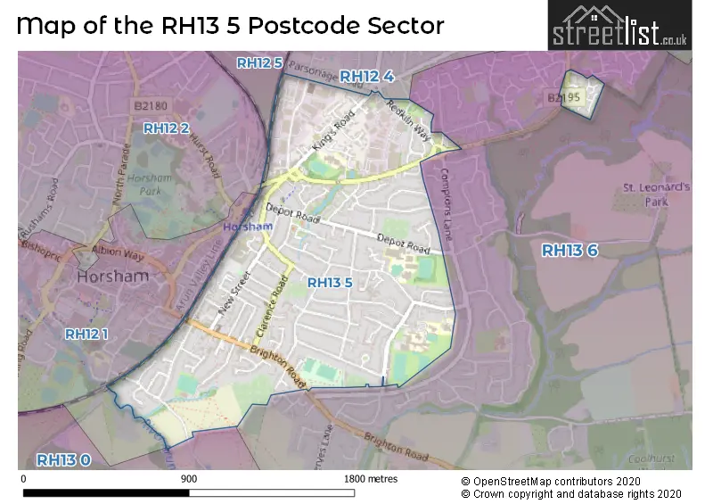
The RH13 5 Postcode shares a border with RH12 1 (HORSHAM), RH12 2 (HORSHAM), RH12 4 (HORSHAM, Faygate, Rusper), RH12 5 (HORSHAM), RH13 0 (Slinfold, Barns Green, Christs Hospital) and RH13 6 (HORSHAM, Mannings Heath, Lower Beeding).
The sector is within the post town of HORSHAM.
RH13 5 is a postcode sector within the RH13 postcode district which is within the RH Redhill postcode area.
The Royal Mail delivery office for the RH13 5 postal sector is the Horsham Delivery Office.
The area of the RH13 5 postcode sector is 0.82 square miles which is 2.11 square kilometres or 521.93 square acres.
Waterways within the RH13 5 postcode sector include the arun.

Map of the RH13 5 Postcode Sector
Explore the RH13 5 postcode sector by using our free interactive map.
| R | H | 1 | 3 | - | 5 | X | X |
| R | H | 1 | 3 | Space | 5 | Letter | Letter |
Official List of Streets
HORSHAM (91 Streets)
Unofficial Streets or Alternative Spellings
HORSHAM
ABBOTSBURY COURT ATHELSTAN WAY COMPTONS BROW LANE COTSWOLD COURT EAST STREET OAK TREE WAY OWLBEECH PLACE OWLBEECH WAY ARUN GARDENS ASHBY COURT BOXALL WALK CHEERY COURT DUNLEY WALK EASTGATE MEWS FOUNDRY COURT GENESIS BUSINESS CENTRE HIGGINS WAY HIGHWORTH HORSHAM TRADE PARK JUBILEE TRADING ESTATE KINGS COURT KINGS PLACE KINGS ROAD ROUNDABOUT MANSTON COURT MILLS CLOSE MOONSTONE MEWS MULBERY ESTATE OWERS CLOSE OWLBEECH COURT QUEENS PARADE SAYERS CLOSE ST. GEORGES GARDENS STANDINGS COURT TANNERY COURT THE COMPTONS THE FORESTERS TRINITY SQUARE TYMPERLEY COURT WESTLANDS WINDSOR COURTLower Beeding
BRIGHTON ROADWeather Forecast for RH13 5
Press Button to Show Forecast for Horsham
| Time Period | Icon | Description | Temperature | Rain Probability | Wind |
|---|---|---|---|---|---|
| 06:00 to 09:00 | Cloudy | 7.0°C (feels like 5.0°C) | 14.00% | WSW 7 mph | |
| 09:00 to 12:00 | Sunny day | 10.0°C (feels like 8.0°C) | 2.00% | W 9 mph | |
| 12:00 to 15:00 | Cloudy | 11.0°C (feels like 9.0°C) | 10.00% | WNW 9 mph | |
| 15:00 to 18:00 | Light rain | 10.0°C (feels like 8.0°C) | 56.00% | W 7 mph | |
| 18:00 to 21:00 | Cloudy | 9.0°C (feels like 8.0°C) | 49.00% | WNW 4 mph | |
| 21:00 to 00:00 | Cloudy | 7.0°C (feels like 6.0°C) | 49.00% | N 4 mph |
Press Button to Show Forecast for Horsham
| Time Period | Icon | Description | Temperature | Rain Probability | Wind |
|---|---|---|---|---|---|
| 00:00 to 03:00 | Cloudy | 6.0°C (feels like 4.0°C) | 6.00% | NE 7 mph | |
| 03:00 to 06:00 | Cloudy | 6.0°C (feels like 3.0°C) | 7.00% | NE 7 mph | |
| 06:00 to 09:00 | Overcast | 6.0°C (feels like 3.0°C) | 10.00% | NE 9 mph | |
| 09:00 to 12:00 | Cloudy | 7.0°C (feels like 5.0°C) | 9.00% | ENE 9 mph | |
| 12:00 to 15:00 | Overcast | 10.0°C (feels like 8.0°C) | 17.00% | ENE 7 mph | |
| 15:00 to 18:00 | Overcast | 11.0°C (feels like 9.0°C) | 15.00% | ENE 7 mph | |
| 18:00 to 21:00 | Cloudy | 10.0°C (feels like 8.0°C) | 12.00% | E 7 mph | |
| 21:00 to 00:00 | Cloudy | 6.0°C (feels like 4.0°C) | 11.00% | E 7 mph |
Press Button to Show Forecast for Horsham
| Time Period | Icon | Description | Temperature | Rain Probability | Wind |
|---|---|---|---|---|---|
| 00:00 to 03:00 | Overcast | 5.0°C (feels like 3.0°C) | 21.00% | ENE 7 mph | |
| 03:00 to 06:00 | Overcast | 5.0°C (feels like 3.0°C) | 24.00% | ENE 7 mph | |
| 06:00 to 09:00 | Cloudy | 6.0°C (feels like 4.0°C) | 18.00% | ENE 9 mph | |
| 09:00 to 12:00 | Overcast | 10.0°C (feels like 8.0°C) | 19.00% | E 11 mph | |
| 12:00 to 15:00 | Cloudy | 12.0°C (feels like 10.0°C) | 17.00% | E 11 mph | |
| 15:00 to 18:00 | Light rain shower (day) | 12.0°C (feels like 10.0°C) | 43.00% | ENE 11 mph | |
| 18:00 to 21:00 | Light rain | 10.0°C (feels like 8.0°C) | 50.00% | ENE 11 mph | |
| 21:00 to 00:00 | Light rain | 9.0°C (feels like 7.0°C) | 53.00% | NE 11 mph |
Press Button to Show Forecast for Horsham
| Time Period | Icon | Description | Temperature | Rain Probability | Wind |
|---|---|---|---|---|---|
| 00:00 to 03:00 | Heavy rain | 9.0°C (feels like 7.0°C) | 71.00% | NE 9 mph | |
| 03:00 to 06:00 | Heavy rain shower (night) | 10.0°C (feels like 7.0°C) | 62.00% | SE 11 mph | |
| 06:00 to 09:00 | Light rain | 9.0°C (feels like 7.0°C) | 47.00% | SE 9 mph | |
| 09:00 to 12:00 | Heavy rain shower (day) | 10.0°C (feels like 8.0°C) | 61.00% | SSE 11 mph | |
| 12:00 to 15:00 | Light rain shower (day) | 13.0°C (feels like 10.0°C) | 42.00% | SSW 13 mph | |
| 15:00 to 18:00 | Light rain shower (day) | 13.0°C (feels like 11.0°C) | 40.00% | SW 11 mph | |
| 18:00 to 21:00 | Light rain shower (day) | 11.0°C (feels like 9.0°C) | 33.00% | WSW 11 mph | |
| 21:00 to 00:00 | Cloudy | 9.0°C (feels like 8.0°C) | 9.00% | WSW 7 mph |
Schools and Places of Education Within the RH13 5 Postcode Sector
Horsham Nursery School
Local authority nursery school
Harwood Road, Horsham, West Sussex, RH13 5UT
Head: Mrs Elizabeth Mellor
Ofsted Rating: Good
Inspection: 2019-11-06 (1632 days ago)
Website: Visit Horsham Nursery School Website
Phone: 014032244430
Number of Pupils: 149
Kingslea Primary School
Community school
Kings Road, Horsham, West Sussex, RH13 5PS
Head: Mr Alexis Conway
Ofsted Rating: Good
Inspection: 2022-05-05 (721 days ago)
Website: Visit Kingslea Primary School Website
Phone: 01403254282
Number of Pupils: 423
Millais School
Community school
Depot Road, Horsham, West Sussex, RH13 5HR
Head: Dr Alison Lodwick
Ofsted Rating: Good
Inspection: 2022-09-14 (589 days ago)
Website: Visit Millais School Website
Phone: 01403254932
Number of Pupils: 1347
Queen Elizabeth II Silver Jubilee School, Horsham
Community special school
Comptons Lane, Horsham, West Sussex, RH13 5NW
Head: Mrs Helen Elphick
Ofsted Rating: Outstanding
Inspection: 2023-05-05 (356 days ago)
Website: Visit Queen Elizabeth II Silver Jubilee School, Horsham Website
Phone: 01403266215
Number of Pupils: 126
The Forest School
Community school
Comptons Lane, Horsham, West Sussex, RH13 5NT
Head: Mr Ian Straw
Ofsted Rating: Good
Inspection: 2022-01-26 (820 days ago)
Website: Visit The Forest School Website
Phone: 01403261086
Number of Pupils: 1023
House Prices in the RH13 5 Postcode Sector
| Type of Property | 2018 Average | 2018 Sales | 2017 Average | 2017 Sales | 2016 Average | 2016 Sales | 2015 Average | 2015 Sales |
|---|---|---|---|---|---|---|---|---|
| Detached | £576,817 | 26 | £561,779 | 29 | £516,464 | 31 | £536,409 | 28 |
| Semi-Detached | £391,182 | 54 | £402,013 | 39 | £374,093 | 54 | £340,802 | 49 |
| Terraced | £355,915 | 18 | £350,421 | 37 | £331,064 | 22 | £320,894 | 34 |
| Flats | £224,536 | 68 | £235,340 | 117 | £214,900 | 191 | £215,330 | 91 |
Important Postcodes RH13 5 in the Postcode Sector
RH13 5AT is the postcode for H M Revenue & Customs, Tower Court, Queensway, and HM Revenue & Customs, Tower Court
RH13 5HR is the postcode for LOWER SCHOOL, Millais School, Depot Road, UPPER SCHOOL, Millais School, Depot Road, Millais School, Depot Road, NEW TEACHING BLOCK, Millais School, Depot Road, and SPORTS HALL, Millais School, Depot Road
RH13 5NT is the postcode for BUSINESS ENTERPRISE CENTRE, The Forest School, Comptons Lane, NEW TEACHING BLOCK, The Forest School, Comptons Lane, and The Forest School, Comptons Lane
RH13 5NW is the postcode for Queen Elizabeth II Silver Jubilee School, Comptons Lane, OAKS BUILDING, Queen Elizabeth II Silver Jubilee School, Comptons Lane, and STUDIO BUILDING, Queen Elizabeth II Silver Jubilee School, Comptons Lane
RH13 5PS is the postcode for Kingslea Primary School, Kingslea
RH13 5RG is the postcode for Strawford Centre, Blatchford Close
RH13 5UT is the postcode for Horsham Nursery & Childrens Centre, Harwood Road
| The RH13 5 Sector is within these Local Authorities |
|
|---|---|
| The RH13 5 Sector is within these Counties |
|
| The RH13 5 Sector is within these Water Company Areas |
|