The RH14 9 postcode sector is within the county of West Sussex.
Did you know? According to the 2021 Census, the RH14 9 postcode sector is home to a bustling 10,903 residents!
Given that each sector allows for 400 unique postcode combinations. Letters C, I, K, M, O and V are not allowed in the last two letters of a postcode. With 321 postcodes already in use, this leaves 79 units available.
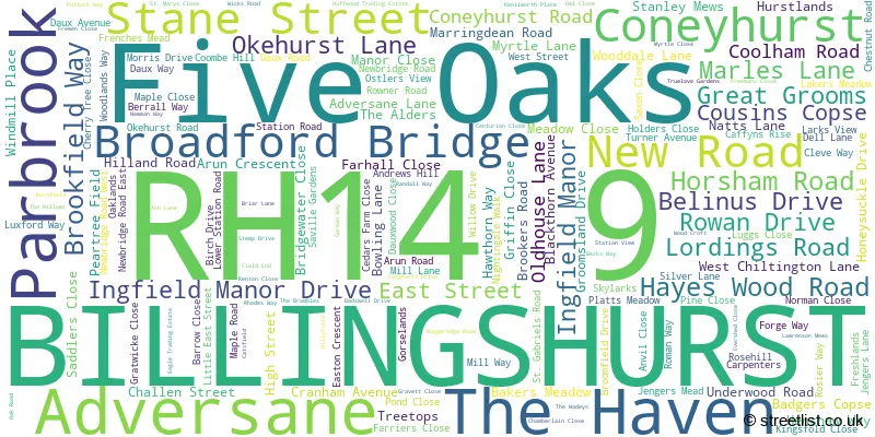
The largest settlement in the RH14 9 postal code is BILLINGSHURST followed by Coneyhurst, and Five Oaks.
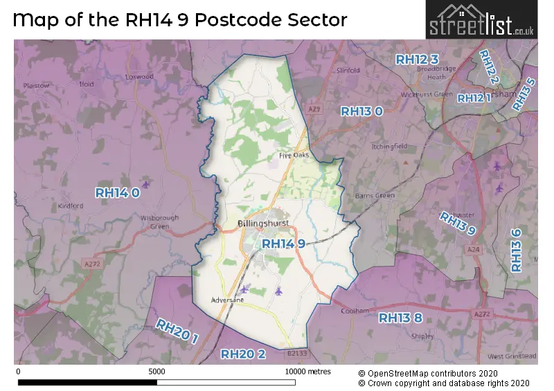
The RH14 9 Postcode shares a border with RH12 3 (Broadbridge Heath, Rudgwick, Warnham), RH13 0 (Slinfold, Barns Green, Christs Hospital), RH13 8 (Partridge Green, Cowfold, Shipley), RH14 0 (Loxwood, Wisborough Green, Kirdford), RH20 1 (PULBOROUGH, Fittleworth, Codmore Hill) and RH20 2 (PULBOROUGH, West Chiltington, Nutbourne).
The sector is within the post town of BILLINGSHURST.
RH14 9 is a postcode sector within the RH14 postcode district which is within the RH Redhill postcode area.
The Royal Mail delivery office for the RH14 9 postal sector is the Billingshurst Delivery Office.
The area of the RH14 9 postcode sector is 16.63 square miles which is 43.07 square kilometres or 10,643.33 square acres.
Waterways within the RH14 9 postcode sector include the River Lox, Wey and Arun Canal, Arun.

Map of the RH14 9 Postcode Sector
Explore the RH14 9 postcode sector by using our free interactive map.
| R | H | 1 | 4 | - | 9 | X | X |
| R | H | 1 | 4 | Space | 9 | Letter | Letter |
Official List of Streets
Adversane (3 Streets)
Broadford Bridge (2 Streets)
BILLINGSHURST (143 Streets)
Coneyhurst (3 Streets)
The Haven (1 Streets)
Parbrook (2 Streets)
Unofficial Streets or Alternative Spellings
Itchingfield
BASHURST HILLConeyhurst
OLDHOUSE LANEBILLINGSHURST
BAKERS MEADOW EAGLE TRADING ESTATE HUFFWOOD TRADING ESTATE MANOR CLOSE ALICKS HILL ARUN ROAD GARAGES BILLINGSHURST BYPASS BILLINGSHURST LEISURE CENTRE BISHOPFIELD BLACKTHORNE AVENUE BRIARS LANE BW1352 CLEVELANDS CONEYHURST FARM COOMBE CLOSE COURT FARM DUNCANS FAIRMEAD FERN COTTAGES FEWHURST FEWHURST FARM FIVE OAKS ROUNDABOUT FP1346 2 FP1347 FRENCHES MEAD GARAGES GIBBONS MILL LANE GILMANS INDUSTRIAL ESTATE GRAININGFOLD GRAININGFOLD FARM GRAVETTE CLOSE GUILDENHURST HADFOLD FARM HAWTHORNE WAY HIGH SEAT COPSE HIGH SEAT GARDENS HILLAND ROUNDABOUT HILLVIEW HILLYFIELDS HONEYSUCKLE WALK JENGERS PASSAGE JUBILEE COURT JUBILEE FIELDS LITTLE DAUX FARM LORDINGS COTTAGES LOWER LODGE MANOR FIELD ALLOTMENTS NEW BRIDGE NEW ROAD ROUNDABOUT NEWSTEAD HALL OSMUND COURT PARBROOK ROUNDABOUT ROSIER COMMERCIAL CENTRE ROSIER GATE ROWAN COURT ROWFOLD GRANGE ROWFOLD KENNELS ROWFOLD NURSERIES SCHOOL LANE SHADOW WOODS SOUTH HOUSE FARM STATION APPROACH STEEPWOOD STEEPWOOD FARM STEEPWOOD LANE STREELE FARM SUMMERS PLACE TEDFOLD TITTLESFOLD TOWING PATH WADEYS WAKOOS WESTLANDS LANEBarns Green
VALEWOOD LANECoolham
BILLINGSHURST ROADWest Chiltington
BROADFORD BRIDGE ROAD HARBOLETS ROADRudgwick
HAVEN ROADWeather Forecast for RH14 9
Press Button to Show Forecast for Billingshurst
| Time Period | Icon | Description | Temperature | Rain Probability | Wind |
|---|---|---|---|---|---|
| 15:00 to 18:00 | Light rain | 10.0°C (feels like 8.0°C) | 50.00% | WSW 9 mph | |
| 18:00 to 21:00 | Cloudy | 9.0°C (feels like 8.0°C) | 45.00% | WSW 4 mph | |
| 21:00 to 00:00 | Cloudy | 8.0°C (feels like 7.0°C) | 42.00% | N 4 mph |
Press Button to Show Forecast for Billingshurst
| Time Period | Icon | Description | Temperature | Rain Probability | Wind |
|---|---|---|---|---|---|
| 00:00 to 03:00 | Cloudy | 7.0°C (feels like 5.0°C) | 6.00% | NE 7 mph | |
| 03:00 to 06:00 | Cloudy | 6.0°C (feels like 4.0°C) | 6.00% | NE 7 mph | |
| 06:00 to 09:00 | Cloudy | 6.0°C (feels like 3.0°C) | 7.00% | NE 9 mph | |
| 09:00 to 12:00 | Cloudy | 8.0°C (feels like 5.0°C) | 9.00% | ENE 9 mph | |
| 12:00 to 15:00 | Overcast | 10.0°C (feels like 8.0°C) | 17.00% | ENE 7 mph | |
| 15:00 to 18:00 | Overcast | 11.0°C (feels like 9.0°C) | 16.00% | ENE 7 mph | |
| 18:00 to 21:00 | Cloudy | 10.0°C (feels like 9.0°C) | 12.00% | ENE 7 mph | |
| 21:00 to 00:00 | Cloudy | 7.0°C (feels like 5.0°C) | 11.00% | E 7 mph |
Press Button to Show Forecast for Billingshurst
| Time Period | Icon | Description | Temperature | Rain Probability | Wind |
|---|---|---|---|---|---|
| 00:00 to 03:00 | Overcast | 5.0°C (feels like 3.0°C) | 21.00% | ENE 7 mph | |
| 03:00 to 06:00 | Cloudy | 5.0°C (feels like 3.0°C) | 21.00% | ENE 7 mph | |
| 06:00 to 09:00 | Cloudy | 6.0°C (feels like 4.0°C) | 18.00% | NE 9 mph | |
| 09:00 to 12:00 | Overcast | 10.0°C (feels like 8.0°C) | 19.00% | E 9 mph | |
| 12:00 to 15:00 | Overcast | 12.0°C (feels like 10.0°C) | 20.00% | E 11 mph | |
| 15:00 to 18:00 | Light rain shower (day) | 12.0°C (feels like 10.0°C) | 43.00% | ENE 11 mph | |
| 18:00 to 21:00 | Light rain | 11.0°C (feels like 8.0°C) | 50.00% | ENE 11 mph | |
| 21:00 to 00:00 | Heavy rain | 10.0°C (feels like 7.0°C) | 73.00% | NE 11 mph |
Press Button to Show Forecast for Billingshurst
| Time Period | Icon | Description | Temperature | Rain Probability | Wind |
|---|---|---|---|---|---|
| 00:00 to 03:00 | Heavy rain | 9.0°C (feels like 7.0°C) | 71.00% | NE 11 mph | |
| 03:00 to 06:00 | Heavy rain shower (night) | 9.0°C (feels like 7.0°C) | 62.00% | SE 9 mph | |
| 06:00 to 09:00 | Light rain | 10.0°C (feels like 8.0°C) | 49.00% | SE 9 mph | |
| 09:00 to 12:00 | Heavy rain shower (day) | 11.0°C (feels like 9.0°C) | 59.00% | SE 11 mph | |
| 12:00 to 15:00 | Heavy rain shower (day) | 13.0°C (feels like 11.0°C) | 58.00% | SW 11 mph | |
| 15:00 to 18:00 | Light rain shower (day) | 13.0°C (feels like 11.0°C) | 40.00% | SW 11 mph | |
| 18:00 to 21:00 | Light rain shower (day) | 11.0°C (feels like 9.0°C) | 33.00% | WSW 11 mph | |
| 21:00 to 00:00 | Cloudy | 9.0°C (feels like 8.0°C) | 8.00% | WSW 7 mph |
Schools and Places of Education Within the RH14 9 Postcode Sector
Billingshurst Primary School
Community school
Upper Station Road, Billingshurst, West Sussex, RH14 9RE
Head: Mr Brian Ball
Ofsted Rating: Requires improvement
Inspection: 2023-03-01 (421 days ago)
Website: Visit Billingshurst Primary School Website
Phone: 01403782789
Number of Pupils: 615
Ingfield Manor School
Non-maintained special school
Ingfield Manor Drive, Billingshurst, West Sussex, RH14 9AX
Head: Mrs Nicola Dodds
Ofsted Rating: Good
Inspection: 2023-11-28 (149 days ago)
Website: Visit Ingfield Manor School Website
Phone: 01403782294
Number of Pupils: 63
Weald School, The
Community school
Station Road, Billingshurst, West Sussex, RH14 9RY
Head: Mrs Sarah Edwards
Ofsted Rating: Outstanding
Inspection: 2013-10-24 (3836 days ago)
Website: Visit Weald School, The Website
Phone: 01403787200
Number of Pupils: 1736
House Prices in the RH14 9 Postcode Sector
| Type of Property | 2018 Average | 2018 Sales | 2017 Average | 2017 Sales | 2016 Average | 2016 Sales | 2015 Average | 2015 Sales |
|---|---|---|---|---|---|---|---|---|
| Detached | £532,806 | 61 | £610,538 | 66 | £475,591 | 75 | £448,888 | 77 |
| Semi-Detached | £374,654 | 59 | £349,704 | 41 | £347,715 | 78 | £330,973 | 66 |
| Terraced | £339,176 | 45 | £313,432 | 30 | £305,779 | 39 | £254,789 | 49 |
| Flats | £230,724 | 29 | £188,732 | 25 | £178,082 | 30 | £154,805 | 37 |
Important Postcodes RH14 9 in the Postcode Sector
RH14 9JZ is the postcode for West Sussex County Council, Billinghurst Library, Mill Lane
RH14 9QW is the postcode for Billingshurst Community & Conference Centre, Roman Way
RH14 9QZ is the postcode for Billinghurst Surgery, Roman Way
RH14 9RE is the postcode for Billingshurst Primary School, Station Road, and Billingshurst Infant School, Station Road
RH14 9RY is the postcode for B & L BLOCK, The Weald Community School and Sixth Form, Station Road, Billingshurst Leisure Centre, Station Road, Weald School, Station Road, YOUTH BLOCK, Weald School, Station Road, NEW TEACHING AND DINING BLOCK, The Weald Community School and Sixth Form, Station Road, C & G BLOCK, The Weald Community School and Sixth Form, Station Road, A BLOCK, The Weald Community School and Sixth Form, Station Road, B & L BLOCK, Weald School, Station Road, A BLOCK, Weald School, Station Road, Billingshurst Children & Family Centre, Station Road, MUSIC BLOCK, Weald School, Station Road, C & G BLOCK, Weald School, Station Road, and NEW TEACHING AND DINING BLOCK, Weald School, Station Road
| The RH14 9 Sector is within these Local Authorities |
|
|---|---|
| The RH14 9 Sector is within these Counties |
|
| The RH14 9 Sector is within these Water Company Areas |
|