The RH15 postcode district is a postal district located in the RH Redhill postcode area with a population of 34,156 residents according to the 2021 England and Wales Census.
The area of the RH15 postcode district is 6.88 square miles which is 17.81 square kilometres or 4,401.24 acres.
Currently, the RH15 district has about 834 postcode units spread across 3 geographic postcode sectors.
Given that each sector allows for 400 unique postcode combinations, the district has a capacity of 1,200 postcodes. With 834 postcodes already in use, this leaves 366 units available.
The RH15 postal code covers the settlement of BURGESS HILL.
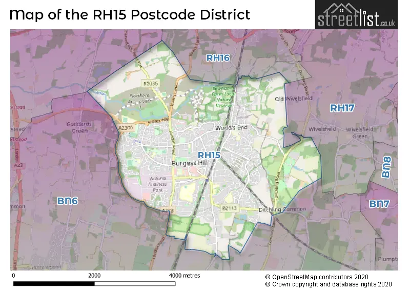
The RH15 Postcode shares a border with RH16 (HAYWARDS HEATH, Lindfield), RH17 (Cuckfield, Balcombe, Ardingly) and BN6 (HASSOCKS, Hurstpierpoint, Ditchling).
The primary settlement in the RH15 postcode district is Burgess Hill. It is located in West Sussex, the county of West Sussex lies within England.
For the district RH15, we have data on 4 postcode sectors. Here's a breakdown: The sector RH15 0, covers Burgess Hill in West Sussex. The sector RH15 0, covers Burgess Hill in East Sussex. The sector RH15 5 is non-geographic. It's often designated for PO Boxes, large organisations, or special services. The sector RH15 8, covers Burgess Hill in West Sussex. The sector RH15 9, covers Burgess Hill in West Sussex.

Map of the RH15 Postcode District
Explore the RH15 postcode district by using our free interactive map.
When it comes to local government, postal geography often disregards political borders. However, for a breakdown in the RH15 District: the district mostly encompasses the Mid Sussex District (804 postcodes), and finally, the Lewes District area (42 postcodes).
Recent House Sales in RH15
| Date | Price | Address |
|---|---|---|
| 19/10/2023 | £470,000 | Pinehurst, Burgess Hill, RH15 0DG |
| 12/10/2023 | £295,000 | Junction Road, Burgess Hill, RH15 0PY |
| 29/09/2023 | £645,000 | Greenlands Drive, Burgess Hill, RH15 0AZ |
| 27/09/2023 | £300,000 | Thatchers Close, Burgess Hill, RH15 0QU |
| 27/09/2023 | £405,500 | The Hornbeams, Burgess Hill, RH15 8XA |
| 19/09/2023 | £350,000 | St Georges Park, Burgess Hill, RH15 0SG |
| 18/09/2023 | £465,000 | Manor Road, Burgess Hill, RH15 0NL |
| 15/09/2023 | £190,000 | The Brow, Burgess Hill, RH15 9DD |
| 15/09/2023 | £370,000 | Foxglove Close, Burgess Hill, RH15 8UY |
| 15/09/2023 | £140,000 | Merrifield Lane, Burgess Hill, RH15 0FR |
Weather Forecast for RH15
Press Button to Show Forecast for Burgess Hill
| Time Period | Icon | Description | Temperature | Rain Probability | Wind |
|---|---|---|---|---|---|
| 18:00 to 21:00 | Cloudy | 9.0°C (feels like 8.0°C) | 15.00% | N 7 mph | |
| 21:00 to 00:00 | Cloudy | 8.0°C (feels like 6.0°C) | 8.00% | N 7 mph |
Press Button to Show Forecast for Burgess Hill
| Time Period | Icon | Description | Temperature | Rain Probability | Wind |
|---|---|---|---|---|---|
| 00:00 to 03:00 | Clear night | 5.0°C (feels like 3.0°C) | 0.00% | NW 4 mph | |
| 03:00 to 06:00 | Cloudy | 4.0°C (feels like 2.0°C) | 3.00% | NW 7 mph | |
| 06:00 to 09:00 | Cloudy | 5.0°C (feels like 2.0°C) | 3.00% | NNW 9 mph | |
| 09:00 to 12:00 | Cloudy | 8.0°C (feels like 4.0°C) | 4.00% | NNW 13 mph | |
| 12:00 to 15:00 | Cloudy | 10.0°C (feels like 7.0°C) | 5.00% | N 11 mph | |
| 15:00 to 18:00 | Cloudy | 11.0°C (feels like 8.0°C) | 4.00% | NNW 11 mph | |
| 18:00 to 21:00 | Cloudy | 10.0°C (feels like 8.0°C) | 3.00% | NNW 7 mph | |
| 21:00 to 00:00 | Partly cloudy (night) | 6.0°C (feels like 5.0°C) | 1.00% | NE 4 mph |
Press Button to Show Forecast for Burgess Hill
| Time Period | Icon | Description | Temperature | Rain Probability | Wind |
|---|---|---|---|---|---|
| 00:00 to 03:00 | Cloudy | 5.0°C (feels like 3.0°C) | 4.00% | E 4 mph | |
| 03:00 to 06:00 | Cloudy | 4.0°C (feels like 3.0°C) | 5.00% | E 4 mph | |
| 06:00 to 09:00 | Cloudy | 5.0°C (feels like 4.0°C) | 4.00% | SW 4 mph | |
| 09:00 to 12:00 | Cloudy | 9.0°C (feels like 7.0°C) | 5.00% | W 9 mph | |
| 12:00 to 15:00 | Light rain | 11.0°C (feels like 9.0°C) | 45.00% | NW 9 mph | |
| 15:00 to 18:00 | Cloudy | 11.0°C (feels like 9.0°C) | 9.00% | WSW 11 mph | |
| 18:00 to 21:00 | Partly cloudy (day) | 10.0°C (feels like 9.0°C) | 5.00% | W 7 mph | |
| 21:00 to 00:00 | Cloudy | 8.0°C (feels like 6.0°C) | 6.00% | W 7 mph |
Press Button to Show Forecast for Burgess Hill
| Time Period | Icon | Description | Temperature | Rain Probability | Wind |
|---|---|---|---|---|---|
| 00:00 to 03:00 | Cloudy | 7.0°C (feels like 5.0°C) | 6.00% | ENE 4 mph | |
| 03:00 to 06:00 | Cloudy | 6.0°C (feels like 4.0°C) | 6.00% | NNE 4 mph | |
| 06:00 to 09:00 | Cloudy | 6.0°C (feels like 4.0°C) | 7.00% | ESE 7 mph | |
| 09:00 to 12:00 | Cloudy | 9.0°C (feels like 7.0°C) | 11.00% | SE 9 mph | |
| 12:00 to 15:00 | Cloudy | 11.0°C (feels like 9.0°C) | 13.00% | SSE 9 mph | |
| 15:00 to 18:00 | Cloudy | 11.0°C (feels like 9.0°C) | 11.00% | SSE 9 mph | |
| 18:00 to 21:00 | Cloudy | 10.0°C (feels like 8.0°C) | 12.00% | SSE 9 mph | |
| 21:00 to 00:00 | Cloudy | 8.0°C (feels like 5.0°C) | 14.00% | ESE 7 mph |
Press Button to Show Forecast for Burgess Hill
| Time Period | Icon | Description | Temperature | Rain Probability | Wind |
|---|---|---|---|---|---|
| 00:00 to 03:00 | Cloudy | 7.0°C (feels like 5.0°C) | 15.00% | ESE 7 mph | |
| 03:00 to 06:00 | Cloudy | 7.0°C (feels like 5.0°C) | 14.00% | ESE 7 mph | |
| 06:00 to 09:00 | Cloudy | 8.0°C (feels like 6.0°C) | 14.00% | ESE 7 mph | |
| 09:00 to 12:00 | Cloudy | 11.0°C (feels like 9.0°C) | 14.00% | SE 9 mph | |
| 12:00 to 15:00 | Light rain | 12.0°C (feels like 10.0°C) | 43.00% | SE 11 mph | |
| 15:00 to 18:00 | Cloudy | 13.0°C (feels like 11.0°C) | 14.00% | SE 11 mph | |
| 18:00 to 21:00 | Cloudy | 12.0°C (feels like 10.0°C) | 15.00% | SE 9 mph | |
| 21:00 to 00:00 | Cloudy | 10.0°C (feels like 8.0°C) | 20.00% | SE 9 mph |
Where is the RH15 Postcode District?
The postcode district RH15 is located in the town of Burgess Hill. Burgess Hill is approximately 37.80 miles away from the center of London. This district is also surrounded by several nearby towns, including Hassocks to the southwest (2.65 miles away), Haywards Heath to the north (3.00 miles away), Henfield to the west (6.52 miles away), Brighton to the south (7.42 miles away), Lewes to the southeast (8.27 miles away), and Uckfield to the east (10.21 miles away).
The district is within the post town of BURGESS HILL.
The sector has postcodes within the nation of England.
The RH15 Postcode District is covers the following regions.
- West Sussex (North East) - Surrey, East and West Sussex - South East (England)
- East Sussex CC - Surrey, East and West Sussex - South East (England)
| Postcode Sector | Delivery Office |
|---|---|
| RH15 0 | Burgess Hill Delivery Office |
| RH15 8 | Burgess Hill Delivery Office |
| RH15 9 | Burgess Hill Delivery Office |
| R | H | 1 | 5 | - | X | X | X |
| R | H | 1 | 5 | Space | Numeric | Letter | Letter |
Current Monthly Rental Prices
| # Bedrooms | Min Price | Max Price | Avg Price |
|---|---|---|---|
| 1 | £725 | £1,100 | £938 |
| 2 | £1,195 | £1,400 | £1,299 |
| 3 | £1,500 | £1,575 | £1,538 |
| 4 | £2,195 | £2,300 | £2,248 |
| 5 | £2,000 | £2,000 | £2,000 |
Current House Prices
| # Bedrooms | Min Price | Max Price | Avg Price |
|---|---|---|---|
| £300,000 | £650,000 | £555,000 | |
| 1 | £158,000 | £300,000 | £210,722 |
| 2 | £208,000 | £650,000 | £355,549 |
| 3 | £150,500 | £1,000,000 | £439,511 |
| 4 | £314,000 | £1,400,000 | £598,783 |
| 5 | £580,000 | £1,000,000 | £762,500 |
| 6 | £550,000 | £1,400,000 | £886,667 |
| 7 | £1,800,000 | £1,800,000 | £1,800,000 |
Estate Agents who Operate in the RH15 District
| Logo | Name | Brand Name | Address | Contact Number | Total Properties |
|---|---|---|---|---|---|
 | Burgess Hill | Mansell McTaggart | 20 Station Road, Burgess Hill, RH15 9DJ | 01444 223527 | 54 |
 | Burgess Hill | Hunters Estate Agents | 1 Church Road, Burgess Hill, RH15 9BB | 01444 223585 | 25 |
 | Burgess Hill | Fox & Sons | 16 Station Road, Burgess Hill, West Sussex, RH15 9DQ | 01444 718186 | 22 |
 | Burgess Hill | PSP Homes | 54 Church Road, Burgess Hill, RH15 9AE | 01444 718219 | 15 |
 | Burgess Hill | Connells | 21 Church Road, Burgess Hill, RH15 9BB | 01444 718201 | 9 |
| Type of Property | 2018 Average | 2018 Sales | 2017 Average | 2017 Sales | 2016 Average | 2016 Sales | 2015 Average | 2015 Sales |
|---|---|---|---|---|---|---|---|---|
| Detached | £484,761 | 159 | £484,978 | 168 | £477,405 | 158 | £441,791 | 157 |
| Semi-Detached | £359,265 | 188 | £358,651 | 181 | £337,000 | 162 | £305,815 | 170 |
| Terraced | £291,228 | 163 | £284,626 | 179 | £275,368 | 159 | £252,319 | 191 |
| Flats | £260,494 | 120 | £243,658 | 114 | £291,826 | 120 | £206,355 | 137 |