The RH19 postcode district is a postal district located in the RH Redhill postcode area with a population of 35,193 residents according to the 2021 England and Wales Census.
The area of the RH19 postcode district is 29.18 square miles which is 75.57 square kilometres or 18,674.62 acres.
Currently, the RH19 district has about 1096 postcode units spread across 4 geographic postcode sectors.
Given that each sector allows for 400 unique postcode combinations, the district has a capacity of 1,600 postcodes. With 1096 postcodes already in use, this leaves 504 units available.
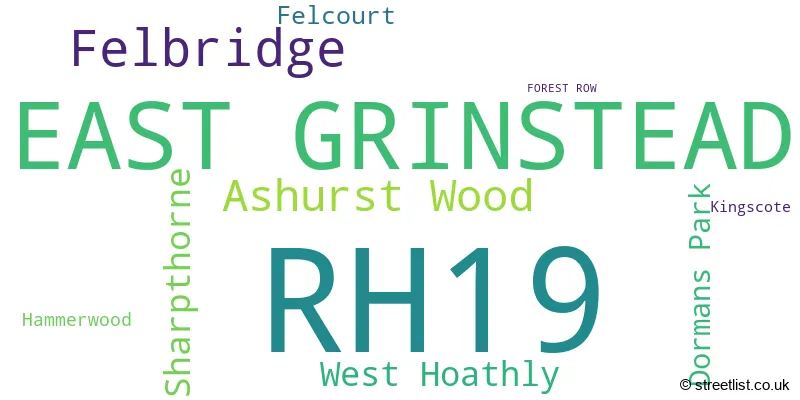
The largest settlement in the RH19 postal code is EAST GRINSTEAD followed by Felbridge, and Ashurst Wood.
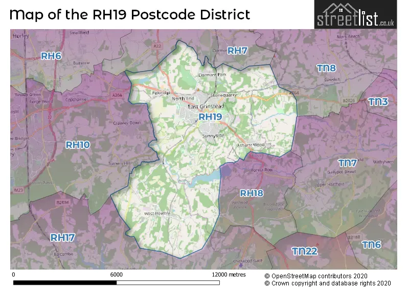
The RH19 Postcode shares a border with RH18 (FOREST ROW, Wych Cross, Weir Wood), RH7 (LINGFIELD, Dormansland, Newchapel), RH17 (Cuckfield, Balcombe, Ardingly) and RH10 (CRAWLEY, Maidenbower, Copthorne).
In the RH19 postcode district, the primary settlement is East Grinstead, which is located in West Sussex, England. The most significant post town in this district is East Grinstead, with the highest number of postcodes. Other significant settlements in the district include Dormans Park, Felbridge, Felcourt, Ashurst Wood, Hammerwood, Kingscote, Sharpthorne, and West Hoathly.
For the district RH19, we have data on 5 postcode sectors. Here's a breakdown: The sector RH19 1, covers East Grinstead in West Sussex. The sector RH19 2, covers East Grinstead in West Sussex. The sector RH19 2, covers Felbridge in Surrey. The sector RH19 3, covers East Grinstead and Ashurst Wood in West Sussex. The sector RH19 4, covers East Grinstead and West Hoathly and Sharpthorne in West Sussex. The sector RH19 9 is non-geographic. It's often designated for PO Boxes, large organisations, or special services.

Map of the RH19 Postcode District
Explore the RH19 postcode district by using our free interactive map.
When it comes to local government, postal geography often disregards political borders. However, for a breakdown in the RH19 District: the district mostly encompasses the Mid Sussex District (997 postcodes), followed by the Tandridge District area (100 postcodes), and finally, the Wealden District area (23 postcodes).
Recent House Sales in RH19
| Date | Price | Address |
|---|---|---|
| 23/10/2023 | £330,000 | Blackwell Farm Road, East Grinstead, RH19 3JW |
| 18/10/2023 | £265,000 | Queens Road, East Grinstead, RH19 1TS |
| 13/10/2023 | £565,000 | Charters Village Drive, East Grinstead, RH19 2GW |
| 06/10/2023 | £720,000 | Windmill Lane, East Grinstead, RH19 2DT |
| 04/10/2023 | £205,000 | St Agnes Road, East Grinstead, RH19 3GF |
| 03/10/2023 | £770,000 | Blount Avenue, East Grinstead, RH19 1JN |
| 03/10/2023 | £120,000 | St Agnes Road, East Grinstead, RH19 3GF |
| 28/09/2023 | £675,000 | Copthorne Road, Felbridge, East Grinstead, RH19 2PD |
| 28/09/2023 | £460,000 | Stoneleigh Close, East Grinstead, RH19 3DY |
| 25/09/2023 | £345,000 | Waterside, East Grinstead, RH19 3XS |
Weather Forecast for RH19
Press Button to Show Forecast for Standen
| Time Period | Icon | Description | Temperature | Rain Probability | Wind |
|---|---|---|---|---|---|
| 00:00 to 03:00 | Cloudy | 4.0°C (feels like 3.0°C) | 4.00% | SSE 4 mph | |
| 03:00 to 06:00 | Cloudy | 4.0°C (feels like 2.0°C) | 4.00% | S 7 mph | |
| 06:00 to 09:00 | Light rain | 6.0°C (feels like 4.0°C) | 50.00% | SSW 7 mph | |
| 09:00 to 12:00 | Partly cloudy (day) | 10.0°C (feels like 7.0°C) | 6.00% | WSW 9 mph | |
| 12:00 to 15:00 | Cloudy | 10.0°C (feels like 8.0°C) | 12.00% | WNW 9 mph | |
| 15:00 to 18:00 | Cloudy | 10.0°C (feels like 8.0°C) | 53.00% | W 11 mph | |
| 18:00 to 21:00 | Light rain | 9.0°C (feels like 7.0°C) | 53.00% | WNW 7 mph | |
| 21:00 to 00:00 | Light rain | 7.0°C (feels like 5.0°C) | 51.00% | N 4 mph |
Press Button to Show Forecast for Standen
| Time Period | Icon | Description | Temperature | Rain Probability | Wind |
|---|---|---|---|---|---|
| 00:00 to 03:00 | Cloudy | 6.0°C (feels like 4.0°C) | 7.00% | NE 4 mph | |
| 03:00 to 06:00 | Cloudy | 5.0°C (feels like 3.0°C) | 6.00% | NE 7 mph | |
| 06:00 to 09:00 | Overcast | 5.0°C (feels like 2.0°C) | 10.00% | NE 9 mph | |
| 09:00 to 12:00 | Cloudy | 7.0°C (feels like 4.0°C) | 8.00% | ENE 9 mph | |
| 12:00 to 15:00 | Overcast | 9.0°C (feels like 7.0°C) | 15.00% | ENE 7 mph | |
| 15:00 to 18:00 | Overcast | 10.0°C (feels like 8.0°C) | 15.00% | E 7 mph | |
| 18:00 to 21:00 | Cloudy | 9.0°C (feels like 7.0°C) | 12.00% | E 7 mph | |
| 21:00 to 00:00 | Cloudy | 6.0°C (feels like 4.0°C) | 11.00% | E 7 mph |
Press Button to Show Forecast for Standen
| Time Period | Icon | Description | Temperature | Rain Probability | Wind |
|---|---|---|---|---|---|
| 00:00 to 03:00 | Cloudy | 5.0°C (feels like 2.0°C) | 16.00% | ENE 7 mph | |
| 03:00 to 06:00 | Overcast | 5.0°C (feels like 2.0°C) | 22.00% | ENE 7 mph | |
| 06:00 to 09:00 | Overcast | 6.0°C (feels like 4.0°C) | 20.00% | ENE 9 mph | |
| 09:00 to 12:00 | Overcast | 10.0°C (feels like 8.0°C) | 17.00% | E 11 mph | |
| 12:00 to 15:00 | Cloudy | 12.0°C (feels like 10.0°C) | 19.00% | E 11 mph | |
| 15:00 to 18:00 | Light rain | 11.0°C (feels like 9.0°C) | 50.00% | E 11 mph | |
| 18:00 to 21:00 | Light rain | 10.0°C (feels like 7.0°C) | 54.00% | ENE 11 mph | |
| 21:00 to 00:00 | Light rain | 9.0°C (feels like 7.0°C) | 51.00% | NE 11 mph |
Press Button to Show Forecast for Standen
| Time Period | Icon | Description | Temperature | Rain Probability | Wind |
|---|---|---|---|---|---|
| 00:00 to 03:00 | Heavy rain | 9.0°C (feels like 7.0°C) | 76.00% | ENE 9 mph | |
| 03:00 to 06:00 | Heavy rain shower (night) | 9.0°C (feels like 7.0°C) | 58.00% | SE 11 mph | |
| 06:00 to 09:00 | Light rain | 9.0°C (feels like 7.0°C) | 48.00% | SE 9 mph | |
| 09:00 to 12:00 | Light rain shower (day) | 10.0°C (feels like 8.0°C) | 46.00% | SSE 13 mph | |
| 12:00 to 15:00 | Heavy rain shower (day) | 12.0°C (feels like 10.0°C) | 60.00% | SSW 13 mph | |
| 15:00 to 18:00 | Light rain shower (day) | 13.0°C (feels like 10.0°C) | 38.00% | SW 13 mph | |
| 18:00 to 21:00 | Light rain shower (day) | 11.0°C (feels like 9.0°C) | 35.00% | WSW 11 mph | |
| 21:00 to 00:00 | Partly cloudy (night) | 9.0°C (feels like 7.0°C) | 7.00% | SW 7 mph |
Where is the RH19 Postcode District?
The RH19 postcode district is located in East Grinstead, a town in the South East. It is situated near several nearby towns, including Forest Row to the South East, Lingfield to the North, Hartfield to the East, Crawley to the West, Horley to the North West, and Haywards Heath to the South West. Additionally, the RH19 postcode district is approximately 27.7 miles away from the center of London.
The district covers the post towns of EAST GRINSTEAD, FOREST ROW.
The sector has postcodes within the nation of England.
The RH19 Postcode District is covers the following regions.
- West Sussex (North East) - Surrey, East and West Sussex - South East (England)
- East Surrey - Surrey, East and West Sussex - South East (England)
- East Sussex CC - Surrey, East and West Sussex - South East (England)
| Postcode Sector | Delivery Office |
|---|---|
| RH19 1 | East Grinstead Delivery Office |
| RH19 2 | East Grinstead Delivery Office |
| RH19 3 | East Grinstead Delivery Office |
| RH19 4 | East Grinstead Delivery Office |
| R | H | 1 | 9 | - | X | X | X |
| R | H | 1 | 9 | Space | Numeric | Letter | Letter |
Current Monthly Rental Prices
| # Bedrooms | Min Price | Max Price | Avg Price |
|---|---|---|---|
| £875 | £1,800 | £1,119 | |
| 1 | £895 | £1,150 | £1,033 |
| 2 | £850 | £1,600 | £1,376 |
| 3 | £1,650 | £1,650 | £1,650 |
| 4 | £1,975 | £5,250 | £3,613 |
| 5 | £4,000 | £4,000 | £4,000 |
| 6 | £4,400 | £4,400 | £4,400 |
Current House Prices
| # Bedrooms | Min Price | Max Price | Avg Price |
|---|---|---|---|
| £5,000 | £4,750,000 | £965,000 | |
| 1 | £75,000 | £310,000 | £174,715 |
| 2 | £160,000 | £699,950 | £314,939 |
| 3 | £195,000 | £1,000,000 | £506,882 |
| 4 | £314,000 | £1,750,000 | £746,288 |
| 5 | £313,500 | £1,750,000 | £953,391 |
| 6 | £825,000 | £1,950,000 | £1,426,818 |
| 7 | £750,000 | £4,000,000 | £2,350,000 |
| 8 | £3,750,000 | £3,750,000 | £3,750,000 |
| 9 | £3,750,000 | £3,750,000 | £3,750,000 |
| 26 | £10,000,000 | £10,000,000 | £10,000,000 |
Estate Agents who Operate in the RH19 District
| Logo | Name | Brand Name | Address | Contact Number | Total Properties |
|---|---|---|---|---|---|
 | East Grinstead | Mansell McTaggart | 52 London Road, East Grinstead, West Sussex, RH19 1AB | 01342 649576 | 52 |
 | East Grinstead | Garnham H Bewley | 73-75 London Road, East Grinstead, West Sussex, RH19 1EQ | 01342 645084 | 51 |
 | East Grinstead | Mayhew Estates | 117 London Road, East Grinstead, West Sussex, RH19 1EQ | 01342 649599 | 39 |
 | East Grinstead | Connells | 90 London Road East Grinstead Sussex, RH19 1EP | 01342 645042 | 37 |
 | East Grinstead | Cubitt & West | 2-3 Whitehall Parade, London Road, East Grinstead, RH19 1AP | 01342 645057 | 28 |
| Type of Property | 2018 Average | 2018 Sales | 2017 Average | 2017 Sales | 2016 Average | 2016 Sales | 2015 Average | 2015 Sales |
|---|---|---|---|---|---|---|---|---|
| Detached | £627,820 | 191 | £606,901 | 194 | £583,484 | 238 | £561,291 | 251 |
| Semi-Detached | £397,117 | 122 | £388,451 | 124 | £384,093 | 122 | £352,857 | 150 |
| Terraced | £324,571 | 104 | £343,491 | 109 | £351,404 | 175 | £298,790 | 129 |
| Flats | £232,704 | 244 | £220,716 | 208 | £229,827 | 266 | £199,749 | 234 |