The RH5 5 postcode sector stands on the Surrey and West Sussex border.
Did you know? According to the 2021 Census, the RH5 5 postcode sector is home to a bustling 5,406 residents!
Given that each sector allows for 400 unique postcode combinations. Letters C, I, K, M, O and V are not allowed in the last two letters of a postcode. With 212 postcodes already in use, this leaves 188 units available.
The largest settlement in the RH5 5 postal code is Newdigate followed by Capel, and Ockley.
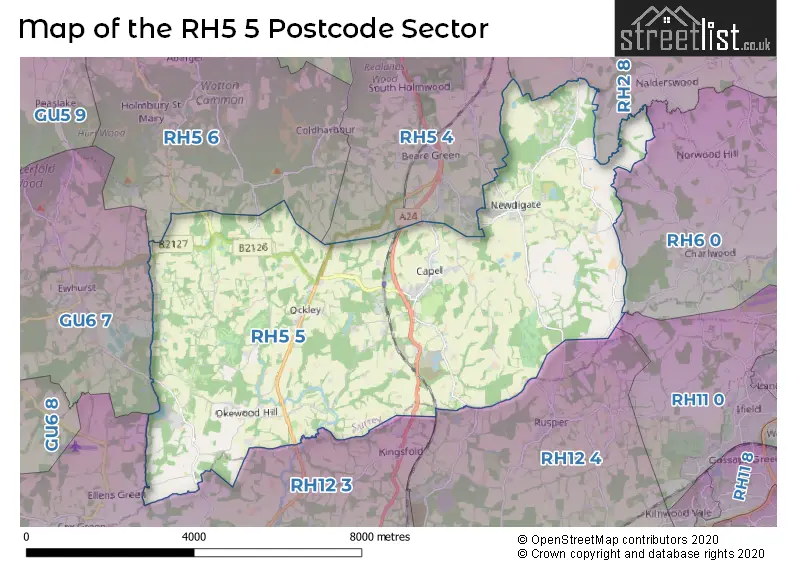
The RH5 5 Postcode shares a border with RH2 8 (REIGATE, Leigh, Sidlow), RH5 4 (Beare Green, North Holmwood, DORKING), RH5 6 (Holmbury St. Mary, Abinger Hammer, Mickleham), RH6 0 (London Gatwick Airport, Charlwood, Hookwood), RH11 0 (CRAWLEY, Ifield, Lowfield Heath), RH12 3 (Broadbridge Heath, Rudgwick, Warnham), RH12 4 (HORSHAM, Faygate, Rusper) and GU6 7 (CRANLEIGH, Ewhurst).
The sector is within the post town of DORKING.
RH5 5 is a postcode sector within the RH5 postcode district which is within the RH Redhill postcode area.
The Royal Mail delivery office for the RH5 5 postal sector is the Dorking Delivery Office.
The area of the RH5 5 postcode sector is 23.88 square miles which is 61.86 square kilometres or 15,285.27 square acres.
Waterways within the RH5 5 postcode sector include the Deanoak Brook.

Map of the RH5 5 Postcode Sector
Explore the RH5 5 postcode sector by using our free interactive map.
| R | H | 5 | - | 5 | X | X |
| R | H | 5 | Space | 5 | Letter | Letter |
Official List of Streets
Capel (18 Streets)
Newdigate (22 Streets)
Ockley (23 Streets)
Okewood Hill (3 Streets)
Walliswood (5 Streets)
Forest Green (5 Streets)
Unofficial Streets or Alternative Spellings
Charlwood
BEGGARHOUSE LANE ABINGER ROAD BROOMEHALL ROAD BW 89 CAPEL BYPASS CARTEDALE COTTAGES CHARLWOOD LANE CHURCH ROAD CIDERMILL ROAD CLARKS GREEN ROUNDABOUT CUDWORTH PARK ETHERLEY HILL FERNBANK CLOSE FOREST GREEN ROAD GREEN LANE GREENHURST PARK GREENS LANE HALES BRIDGE HOGGSPUDDING LANE HOLMBURY ROAD HONEY LANE INGLENOOK YARD JUGSHILL LANE LAZENBYS ESTATE LEITH VALE COTTAGES LOWERHOUSE LANE MEDLAR COURT MONKS LANE MUGGERIDGES HILL MULLBERRY PLACE NUNNS FIELD PARK LANE PARTRIGE LANE PISLEY LANE POND HEAD LANE PRIDEAUX GARDENS RECTORYCLOSE SCHOOL LANE SEAMANS GREEN SMOKEJACK HILL SMUGGLERS LANE STREET LAKE THE POPLARS TRIG STREET VANN LAKE WALEYS LANE WATTLEHURST DRIVE WOLVES HILLRusper
CAPEL ROADBeare Green
HENFOLD LANE MISBROOKS GREEN ROADHolmbury St. Mary
COTTON ROW LEITH HILL LANE TANHURST LANEEwhurst
LOWER BREACHE ROAD OCKLEY ROADKingsfold
DORKING ROADBroadbridge Heath
BOGNOR ROADRudgwick
FURZEN LANEWeather Forecast for RH5 5
Press Button to Show Forecast for Capel
| Time Period | Icon | Description | Temperature | Rain Probability | Wind |
|---|---|---|---|---|---|
| 06:00 to 09:00 | Cloudy | 9.0°C (feels like 7.0°C) | 14.00% | WNW 11 mph | |
| 09:00 to 12:00 | Overcast | 11.0°C (feels like 8.0°C) | 13.00% | NW 13 mph | |
| 12:00 to 15:00 | Cloudy | 12.0°C (feels like 9.0°C) | 11.00% | NW 16 mph | |
| 15:00 to 18:00 | Cloudy | 12.0°C (feels like 9.0°C) | 30.00% | NNW 13 mph | |
| 18:00 to 21:00 | Cloudy | 10.0°C (feels like 7.0°C) | 7.00% | N 9 mph | |
| 21:00 to 00:00 | Cloudy | 7.0°C (feels like 5.0°C) | 6.00% | NNE 7 mph |
Press Button to Show Forecast for Capel
| Time Period | Icon | Description | Temperature | Rain Probability | Wind |
|---|---|---|---|---|---|
| 00:00 to 03:00 | Partly cloudy (night) | 5.0°C (feels like 3.0°C) | 2.00% | N 7 mph | |
| 03:00 to 06:00 | Clear night | 4.0°C (feels like 1.0°C) | 1.00% | N 9 mph | |
| 06:00 to 09:00 | Partly cloudy (day) | 4.0°C (feels like 1.0°C) | 2.00% | NNW 9 mph | |
| 09:00 to 12:00 | Cloudy | 7.0°C (feels like 4.0°C) | 5.00% | N 11 mph | |
| 12:00 to 15:00 | Overcast | 9.0°C (feels like 6.0°C) | 8.00% | N 11 mph | |
| 15:00 to 18:00 | Overcast | 10.0°C (feels like 8.0°C) | 9.00% | N 11 mph | |
| 18:00 to 21:00 | Overcast | 9.0°C (feels like 7.0°C) | 9.00% | N 9 mph | |
| 21:00 to 00:00 | Cloudy | 7.0°C (feels like 5.0°C) | 5.00% | NNE 7 mph |
Press Button to Show Forecast for Capel
| Time Period | Icon | Description | Temperature | Rain Probability | Wind |
|---|---|---|---|---|---|
| 00:00 to 03:00 | Partly cloudy (night) | 5.0°C (feels like 3.0°C) | 2.00% | N 4 mph | |
| 03:00 to 06:00 | Partly cloudy (night) | 4.0°C (feels like 2.0°C) | 2.00% | N 4 mph | |
| 06:00 to 09:00 | Cloudy | 5.0°C (feels like 3.0°C) | 5.00% | N 4 mph | |
| 09:00 to 12:00 | Overcast | 8.0°C (feels like 5.0°C) | 9.00% | NNE 9 mph | |
| 12:00 to 15:00 | Overcast | 9.0°C (feels like 7.0°C) | 9.00% | NNE 9 mph | |
| 15:00 to 18:00 | Overcast | 11.0°C (feels like 8.0°C) | 10.00% | NNE 11 mph | |
| 18:00 to 21:00 | Cloudy | 9.0°C (feels like 7.0°C) | 7.00% | NNE 9 mph | |
| 21:00 to 00:00 | Partly cloudy (night) | 7.0°C (feels like 5.0°C) | 3.00% | NE 9 mph |
Press Button to Show Forecast for Capel
| Time Period | Icon | Description | Temperature | Rain Probability | Wind |
|---|---|---|---|---|---|
| 00:00 to 03:00 | Partly cloudy (night) | 5.0°C (feels like 3.0°C) | 5.00% | NNE 7 mph | |
| 03:00 to 06:00 | Clear night | 4.0°C (feels like 2.0°C) | 3.00% | NNE 7 mph | |
| 06:00 to 09:00 | Partly cloudy (day) | 5.0°C (feels like 3.0°C) | 2.00% | NNE 7 mph | |
| 09:00 to 12:00 | Partly cloudy (day) | 8.0°C (feels like 6.0°C) | 3.00% | NE 11 mph | |
| 12:00 to 15:00 | Cloudy | 10.0°C (feels like 8.0°C) | 8.00% | NE 11 mph | |
| 15:00 to 18:00 | Cloudy | 10.0°C (feels like 8.0°C) | 7.00% | NE 11 mph | |
| 18:00 to 21:00 | Cloudy | 9.0°C (feels like 7.0°C) | 7.00% | NE 9 mph | |
| 21:00 to 00:00 | Partly cloudy (night) | 6.0°C (feels like 4.0°C) | 3.00% | NE 7 mph |
Schools and Places of Education Within the RH5 5 Postcode Sector
Newdigate CofE Endowed Aided Infant School
Voluntary aided school
Village Street, Dorking, Surrey, RH5 5DJ
Head: Mrs Paula Bliss
Ofsted Rating: Good
Inspection: 2023-09-26 (206 days ago)
Website: Visit Newdigate CofE Endowed Aided Infant School Website
Phone: 01306631353
Number of Pupils: 71
House Prices in the RH5 5 Postcode Sector
| Type of Property | 2018 Average | 2018 Sales | 2017 Average | 2017 Sales | 2016 Average | 2016 Sales | 2015 Average | 2015 Sales |
|---|---|---|---|---|---|---|---|---|
| Detached | £749,299 | 24 | £837,780 | 25 | £761,625 | 32 | £729,530 | 29 |
| Semi-Detached | £497,177 | 14 | £504,056 | 18 | £513,641 | 19 | £479,569 | 21 |
| Terraced | £356,679 | 7 | £384,000 | 10 | £294,750 | 9 | £291,586 | 11 |
| Flats | £232,667 | 6 | £214,136 | 7 | £214,571 | 7 | £290,167 | 6 |
Important Postcodes RH5 5 in the Postcode Sector
RH5 5JX is the postcode for SCOTT BROADWOOD SCHOOL, THE STREET, CAPEL
| The RH5 5 Sector is within these Local Authorities |
|
|---|---|
| The RH5 5 Sector is within these Counties |
|
| The RH5 5 Sector is within these Water Company Areas |
|