The RH9 postcode district is a postal district located in the RH Redhill postcode area with a population of 5,649 residents according to the 2021 England and Wales Census.
The area of the RH9 postcode district is 9.21 square miles which is 23.86 square kilometres or 5,895.32 acres.
Currently, the RH9 district has about 152 postcode units spread across 1 geographic postcode sectors.
Given that each sector allows for 400 unique postcode combinations, the district has a capacity of 400 postcodes. With 152 postcodes already in use, this leaves 248 units available.
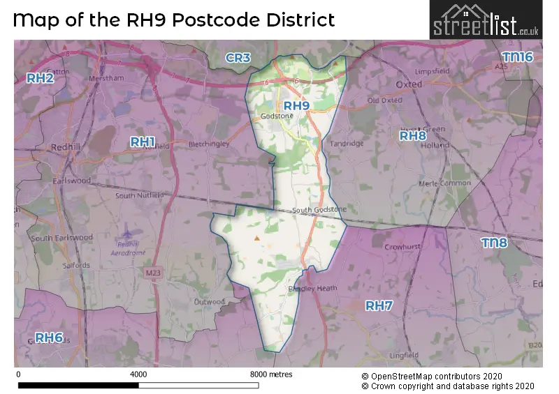
The largest settlements in the RH9 postal code are GODSTONE and South Godstone.
The RH9 Postcode shares a border with RH7 (LINGFIELD, Dormansland, Newchapel), RH1 (REDHILL, MERSTHAM, BLETCHINGLEY), CR3 (CATERHAM, WHYTELEAFE) and RH8 (OXTED, HURST GREEN, LIMPSFIELD).
The primary settlement in the RH9 postcode district is Godstone, located in the county of Surrey, England. The most significant postal town in this district is Godstone.
For the district RH9, we have data on 1 postcode sectors. Here's a breakdown: The sector RH9 8, covers Godstone and South Godstone in Surrey.
RH9 Postcode Sectors


Map of the RH9 Postcode District
Explore the RH9 postcode district by using our free interactive map.
When it comes to local government, postal geography often disregards political borders. However, for a breakdown in the RH9 District: the district mostly encompasses the Tandridge District area with a total of 149 postcodes.
Recent House Sales in RH9
| Date | Price | Address |
|---|---|---|
| 11/09/2023 | £161,000 | High Street, Godstone, RH9 8LS |
| 23/08/2023 | £520,000 | Bletchingley Road, Godstone, RH9 8LL |
| 23/08/2023 | £550,000 | Oxted Road, Godstone, RH9 8AD |
| 11/08/2023 | £350,000 | Easter Way, South Godstone, Godstone, RH9 8HQ |
| 07/07/2023 | £825,000 | Orme Cottages, South Godstone, Godstone, RH9 8NP |
| 23/06/2023 | £575,000 | Lagham Park, South Godstone, Godstone, RH9 8ER |
| 16/06/2023 | £410,000 | Easter Way, South Godstone, Godstone, RH9 8HG |
| 14/06/2023 | £369,000 | Carlton Road, South Godstone, Godstone, RH9 8LH |
| 08/06/2023 | £1,562,500 | Church Lane, Godstone, RH9 8BW |
| 01/06/2023 | £322,500 | High Street, Godstone, RH9 8LS |
Weather Forecast for RH9
Press Button to Show Forecast for Redhill Aerodrome & Heliport
| Time Period | Icon | Description | Temperature | Rain Probability | Wind |
|---|---|---|---|---|---|
| 15:00 to 18:00 | Cloudy | 11.0°C (feels like 9.0°C) | 7.00% | NNW 7 mph | |
| 18:00 to 21:00 | Overcast | 9.0°C (feels like 7.0°C) | 12.00% | NNE 9 mph | |
| 21:00 to 00:00 | Cloudy | 7.0°C (feels like 6.0°C) | 4.00% | NNE 4 mph |
Press Button to Show Forecast for Redhill Aerodrome & Heliport
| Time Period | Icon | Description | Temperature | Rain Probability | Wind |
|---|---|---|---|---|---|
| 00:00 to 03:00 | Partly cloudy (night) | 5.0°C (feels like 3.0°C) | 0.00% | NNW 4 mph | |
| 03:00 to 06:00 | Cloudy | 4.0°C (feels like 2.0°C) | 3.00% | NNW 7 mph | |
| 06:00 to 09:00 | Cloudy | 5.0°C (feels like 2.0°C) | 4.00% | NNW 9 mph | |
| 09:00 to 12:00 | Cloudy | 8.0°C (feels like 5.0°C) | 4.00% | NNW 11 mph | |
| 12:00 to 15:00 | Cloudy | 10.0°C (feels like 7.0°C) | 4.00% | NNW 11 mph | |
| 15:00 to 18:00 | Cloudy | 11.0°C (feels like 8.0°C) | 4.00% | NNW 11 mph | |
| 18:00 to 21:00 | Cloudy | 9.0°C (feels like 7.0°C) | 5.00% | NNW 9 mph | |
| 21:00 to 00:00 | Partly cloudy (night) | 5.0°C (feels like 3.0°C) | 1.00% | NE 4 mph |
Press Button to Show Forecast for Redhill Aerodrome & Heliport
| Time Period | Icon | Description | Temperature | Rain Probability | Wind |
|---|---|---|---|---|---|
| 00:00 to 03:00 | Cloudy | 4.0°C (feels like 3.0°C) | 4.00% | E 2 mph | |
| 03:00 to 06:00 | Cloudy | 4.0°C (feels like 2.0°C) | 4.00% | W 4 mph | |
| 06:00 to 09:00 | Cloudy | 5.0°C (feels like 4.0°C) | 4.00% | WSW 4 mph | |
| 09:00 to 12:00 | Partly cloudy (day) | 9.0°C (feels like 7.0°C) | 3.00% | W 9 mph | |
| 12:00 to 15:00 | Cloudy | 11.0°C (feels like 9.0°C) | 8.00% | W 9 mph | |
| 15:00 to 18:00 | Cloudy | 12.0°C (feels like 10.0°C) | 9.00% | WNW 9 mph | |
| 18:00 to 21:00 | Cloudy | 10.0°C (feels like 9.0°C) | 8.00% | W 7 mph | |
| 21:00 to 00:00 | Cloudy | 8.0°C (feels like 7.0°C) | 8.00% | N 4 mph |
Press Button to Show Forecast for Redhill Aerodrome & Heliport
| Time Period | Icon | Description | Temperature | Rain Probability | Wind |
|---|---|---|---|---|---|
| 00:00 to 03:00 | Cloudy | 7.0°C (feels like 5.0°C) | 6.00% | NNW 4 mph | |
| 03:00 to 06:00 | Cloudy | 6.0°C (feels like 4.0°C) | 6.00% | ENE 4 mph | |
| 06:00 to 09:00 | Cloudy | 6.0°C (feels like 4.0°C) | 8.00% | ENE 7 mph | |
| 09:00 to 12:00 | Cloudy | 9.0°C (feels like 7.0°C) | 9.00% | ESE 7 mph | |
| 12:00 to 15:00 | Light rain | 10.0°C (feels like 8.0°C) | 55.00% | SE 9 mph | |
| 15:00 to 18:00 | Light rain shower (day) | 11.0°C (feels like 9.0°C) | 30.00% | SE 7 mph | |
| 18:00 to 21:00 | Cloudy | 10.0°C (feels like 8.0°C) | 11.00% | SSE 9 mph | |
| 21:00 to 00:00 | Cloudy | 8.0°C (feels like 6.0°C) | 11.00% | ESE 7 mph |
Press Button to Show Forecast for Redhill Aerodrome & Heliport
| Time Period | Icon | Description | Temperature | Rain Probability | Wind |
|---|---|---|---|---|---|
| 00:00 to 03:00 | Cloudy | 7.0°C (feels like 5.0°C) | 14.00% | ESE 7 mph | |
| 03:00 to 06:00 | Cloudy | 7.0°C (feels like 5.0°C) | 15.00% | ESE 7 mph | |
| 06:00 to 09:00 | Cloudy | 8.0°C (feels like 6.0°C) | 14.00% | ESE 7 mph | |
| 09:00 to 12:00 | Overcast | 10.0°C (feels like 9.0°C) | 17.00% | SE 9 mph | |
| 12:00 to 15:00 | Light rain shower (day) | 12.0°C (feels like 10.0°C) | 33.00% | SE 9 mph | |
| 15:00 to 18:00 | Cloudy | 13.0°C (feels like 11.0°C) | 16.00% | SE 9 mph | |
| 18:00 to 21:00 | Light rain shower (day) | 12.0°C (feels like 10.0°C) | 32.00% | SE 9 mph | |
| 21:00 to 00:00 | Cloudy | 10.0°C (feels like 8.0°C) | 20.00% | ESE 9 mph |
Where is the RH9 Postcode District?
The postcode district RH9 is located in the town of Godstone. Godstone is nearby several towns including Tandridge which is located to the North East, Bletchingley to the North West, Nutfield to the West, Hurst Green to the East, Lingfield to the South East, and Caterham to the North. The distance between Godstone and the center of London is approximately 19.68 miles.
The district is within the post town of GODSTONE.
The sector has postcodes within the nation of England.
The RH9 Postcode District is in the East Surrey region of Surrey, East and West Sussex within the South East (England).
Postcode Sectors within the RH9 District
| Postcode Sector | Delivery Office |
|---|---|
| RH9 8 | Redhill Delivery Office |
| R | H | 9 | - | X | X | X |
| R | H | 9 | Space | Numeric | Letter | Letter |
Tourist Attractions within the Postcode Area
We found 1 visitor attractions within the RH9 postcode area
| Godstone Farm |
|---|
| Farms |
| Farm / Rare Breeds / Farm Animals |
| View Godstone Farm on Google Maps |
Current Monthly Rental Prices
| # Bedrooms | Min Price | Max Price | Avg Price |
|---|---|---|---|
| 2 | £850 | £1,300 | £1,075 |
| 3 | £1,750 | £1,750 | £1,750 |
| 4 | £3,150 | £3,150 | £3,150 |
| 5 | £5,250 | £5,250 | £5,250 |
Current House Prices
| # Bedrooms | Min Price | Max Price | Avg Price |
|---|---|---|---|
| £750,000 | £750,000 | £750,000 | |
| 2 | £270,000 | £425,000 | £327,000 |
| 3 | £375,000 | £825,000 | £597,368 |
| 4 | £400,000 | £1,500,000 | £849,992 |
| 5 | £700,000 | £2,900,000 | £1,516,667 |
Estate Agents who Operate in the RH9 District
| Logo | Name | Brand Name | Address | Contact Number | Total Properties |
|---|---|---|---|---|---|
 | Oxted | Robert Leech Estate Agents | 72 Station Road East, Oxted, RH8 0PG | 01883 779596 | 8 |
 | Warlingham | Rayners Town & Country | 2 Glebe Road, Warlingham, CR6 9NJ | 01883 771152 | 5 |
 | Oxted | White & Sons | 39-41 Station Road East, Oxted, RH8 0BD | 01883 771082 | 3 |
 | East Grinstead | Mayhew Estates | 117 London Road, East Grinstead, West Sussex, RH19 1EQ | 01342 649599 | 2 |
 | Caterham | Cubitt & West | 53 Croydon Road, Caterham, Surrey, CR3 6PD | 01883 779599 | 2 |
| Type of Property | 2018 Average | 2018 Sales | 2017 Average | 2017 Sales | 2016 Average | 2016 Sales | 2015 Average | 2015 Sales |
|---|---|---|---|---|---|---|---|---|
| Detached | £620,023 | 31 | £672,248 | 30 | £649,165 | 18 | £505,556 | 9 |
| Semi-Detached | £417,860 | 36 | £416,762 | 42 | £356,295 | 23 | £379,194 | 29 |
| Terraced | £381,957 | 23 | £359,234 | 31 | £371,083 | 21 | £315,389 | 27 |
| Flats | £279,444 | 9 | £266,962 | 13 | £256,181 | 18 | £256,997 | 15 |